Bridge Statistics for Atlanta, Georgia (GA)
Condition, Traffic, Stress, Structural Evaluation, Project Costs
- National Bridge Inventory (NBI) Statistics
- 943Number of bridges
- 11,804ft / 3,598mTotal length
- $2,063,749,000Total costs
- 46,196,877Total average daily traffic
- 629,964Total average daily truck traffic
- National Bridge Inventory (NBI) Registered Bridges for Atlanta
- No street view available for this location
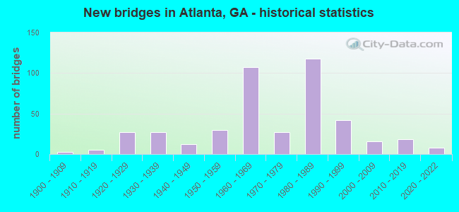
- New bridges - historical statistics
- 31900-1909
- 51910-1919
- 271920-1929
- 271930-1939
- 121940-1949
- 301950-1959
- 1071960-1969
- 271970-1979
- 1181980-1989
- 421990-1999
- 162000-2009
- 182010-2019
- 82020-2022
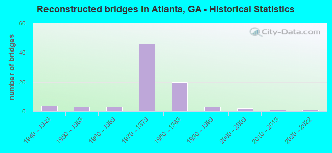
- Reconstructed bridges - Historical Statistics
- 41940-1949
- 31950-1959
- 31960-1969
- 461970-1979
- 201980-1989
- 31990-1999
- 22000-2009
- 12010-2019
- 12020-2022
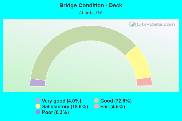
- Bridge Condition - Deck
- 4.0%Very good
- 72.6%Good
- 18.6%Satisfactory
- 4.5%Fair
- 0.3%Poor
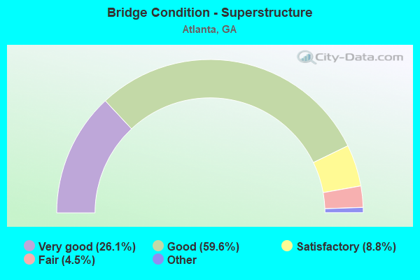
- Bridge Condition - Superstructure
- 26.1%Very good
- 59.6%Good
- 8.8%Satisfactory
- 4.5%Fair
- 1.1%Poor
- 0.3%Imminent failure
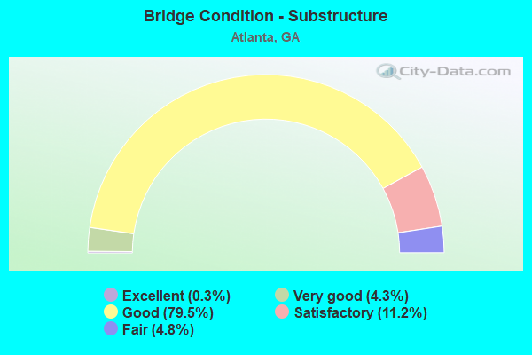
- Bridge Condition - Substructure
- 0.3%Excellent
- 4.3%Very good
- 79.5%Good
- 11.2%Satisfactory
- 4.8%Fair
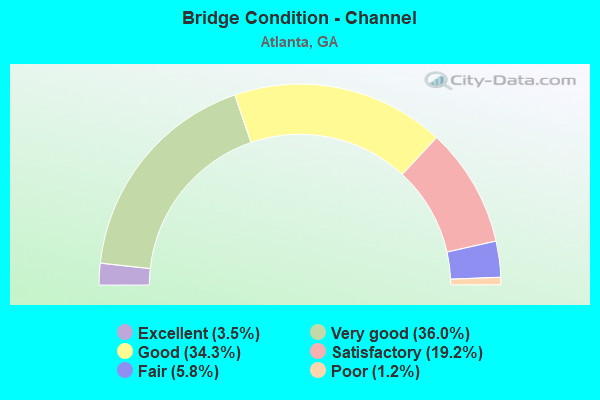
- Bridge Condition - Channel
- 3.5%Excellent
- 36.0%Very good
- 34.3%Good
- 19.2%Satisfactory
- 5.8%Fair
- 1.2%Poor
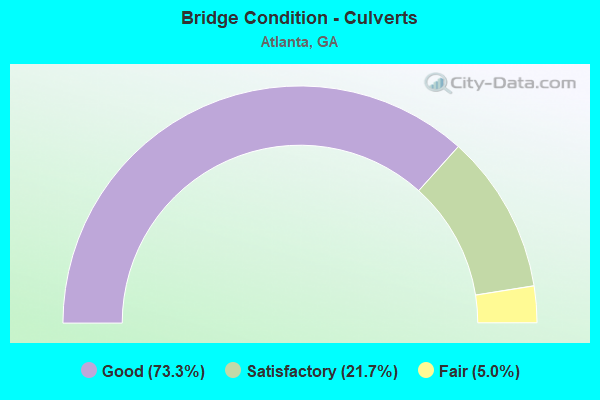
- Bridge Condition - Culverts
- 73.3%Good
- 21.7%Satisfactory
- 5.0%Fair
Find on map >> Show street view
Structure Number: 1210558, Location: IN N ATLANTA (Lat: 33.822608, Lng: -84.358350), Route carried "under" structure: Ramp State highway 236, Structure Length: 0. m, Average Daily Traffic: 2,600 (year 1996), Truck Traffic: 1%, Features Intersected: I-85 RAMP SB TO SR 13, Facility Carried by Structure: I-85 RMP SB TO SR1
Minimum Vertical Clearance: 7.36m (24.15ft), Kilometerpoint: 0.000, Lanes on structure: 1, Length of Maximum Span: 0.0m
Find on map >> Show street view
Structure Number: 1210558, Location: IN N ATLANTA (Lat: 33.822608, Lng: -84.358350), Route carried "under" structure: State highway 13, Structure Length: 0. m, Average Daily Traffic: 71,300 (year 1995), Truck Traffic: 1%, Features Intersected: I-85 RAMP SB TO SR 13, Facility Carried by Structure: I-85 RMP SB TO SR1
Minimum Vertical Clearance: 8.73m (28.64ft), Kilometerpoint: 4.828, Lanes on structure: 1, Length of Maximum Span: 0.0m
Find on map >> Show street view
Structure Number: 1210562, Location: IN N ATLANTA (Lat: 33.806083, Lng: -84.381514), Route carried "under" structure: State highway 13, Structure Length: 0. m, Average Daily Traffic: 60,360 (year 2009), Truck Traffic: 1%, Features Intersected: I-85, Facility Carried by Structure: I-85
Minimum Vertical Clearance: 5.51m (18.08ft), Kilometerpoint: 3.219, Lanes on structure: 11, Length of Maximum Span: 0.0m
Find on map >> Show street view
Structure Number: 1210563, Location: IN N. W. ATLANTA (Lat: 33.764628, Lng: -84.391128), Route carried "under" structure: City street 9073, Structure Length: 0. m, Average Daily Traffic: 15,179 (year 1990), Truck Traffic: 1%, Features Intersected: M-9045 ALEXANDER STREET, Facility Carried by Structure: ALEXANDER STREET
Minimum Vertical Clearance: 5.23m (17.16ft), Kilometerpoint: 3.219, Lanes on structure: 3, Length of Maximum Span: 0.0m
Find on map >> Show street view
Structure Number: 1210566, Location: IN ATLANTA (Lat: 33.765439, Lng: -84.390306), Route carried "under" structure: City street 9073, Structure Length: 0. m, Average Daily Traffic: 15,175 (year 1990), Truck Traffic: 1%, Features Intersected: M-9200 WILLIAMS STREET, Facility Carried by Structure: WILLIAMS STREET
Minimum Vertical Clearance: 5.25m (17.22ft), Kilometerpoint: 3.219, Lanes on structure: 6, Length of Maximum Span: 0.0m
Find on map >> Show street view
Structure Number: 1210567, Location: IN WEST ATLANTA (Lat: 33.731297, Lng: -84.414247), Route carried "under" structure: State highway 14, Structure Length: 0. m, Average Daily Traffic: 19,420 (year 2012), Truck Traffic: 1%, Features Intersected: SR 14 LEE STREET, Facility Carried by Structure: MARTA BRIDGE
Minimum Vertical Clearance: 5.48m (17.98ft), Kilometerpoint: 38.624, Length of Maximum Span: 0.0m
Find on map >> Show street view
Structure Number: 1210568, Location: IN NORTH ATLANTA (Lat: 33.828269, Lng: -84.367328), Route carried "under" structure: State highway 237, Structure Length: 0. m, Average Daily Traffic: 37,390 (year 2012), Truck Traffic: 1%, Features Intersected: SR 237 PIEDMONT ROAD, Facility Carried by Structure: MARTA
Minimum Vertical Clearance: 5.71m (18.73ft), Kilometerpoint: 1.609, Length of Maximum Span: 0.0m
Find on map >> Show street view
Structure Number: 1210569, Location: IN W ATLANTA (Lat: 33.754619, Lng: -84.467728), Route carried "under" structure: State highway 280, Structure Length: 0. m, Average Daily Traffic: 13,770 (year 2012), Truck Traffic: 4%, Features Intersected: SR 280 HIGHTOWER ROAD, Facility Carried by Structure: MARTA
Minimum Vertical Clearance: 8.81m (28.90ft), Kilometerpoint: 0.000, Length of Maximum Span: 0.0m
Find on map >> Show street view
Structure Number: 121057, Location: IN CITY OF ATLANTA (Lat: 33.752739, Lng: -84.387100), Route carried "under" structure: City street 9003, Structure Length: 0. m, Average Daily Traffic: 19,610 (year 2011), Truck Traffic: 1%, Features Intersected: M-9003 DECATUR STREET, Facility Carried by Structure: PED. OVERPASS
Minimum Vertical Clearance: 4.92m (16.14ft), Kilometerpoint: 0.000, Length of Maximum Span: 0.0m
Find on map >> Show street view
Structure Number: 1210571, Location: IN CITY OF ATLANTA (Lat: 33.752008, Lng: -84.386069), Route carried "under" structure: City street 9003, Structure Length: 0. m, Average Daily Traffic: 19,610 (year 2011), Truck Traffic: 1%, Features Intersected: M-9003 DECATUR STREET, Facility Carried by Structure: PED. OVERPASS
Minimum Vertical Clearance: 5.20m (17.06ft), Kilometerpoint: 0.000, Length of Maximum Span: 0.0m
Find on map >> Show street view
Structure Number: 1210572, Location: IN CITY OF ATLANTA (Lat: 33.751878, Lng: -84.385908), Route carried "under" structure: City street 9003, Structure Length: 0. m, Average Daily Traffic: 19,610 (year 2011), Truck Traffic: 1%, Features Intersected: M-9003 DECATUR STREET, Facility Carried by Structure: PED. OVERPASS
Minimum Vertical Clearance: 5.68m (18.64ft), Kilometerpoint: 0.000, Length of Maximum Span: 0.0m
Find on map >> Show street view
Structure Number: 1210583, Location: IN N ATLANTA (Lat: 33.848619, Lng: -84.352339), Route carried "under" structure: County highway 9219, Structure Length: 0. m, Average Daily Traffic: 16,640 (year 2007), Truck Traffic: 1%, Features Intersected: M-9219 ROXBORO ROAD, Facility Carried by Structure: MARTA BRIDGE
Minimum Vertical Clearance: 6.65m (21.82ft), Kilometerpoint: 0.000, Length of Maximum Span: 0.0m
Find on map >> Show street view
Structure Number: 1210584, Location: IN CITY OF ATLANTA (Lat: 33.758669, Lng: -84.394708), Route carried "under" structure: City street 9315, Structure Length: 0. m, Average Daily Traffic: 6,620 (year 2011), Truck Traffic: 1%, Features Intersected: M9315 INTERNATIONAL BLVD, Facility Carried by Structure: PED OVERPASS
Minimum Vertical Clearance: 7.39m (24.25ft), Kilometerpoint: 0.000, Length of Maximum Span: 0.0m
Find on map >> Show street view
Structure Number: 1210594, Location: IN ATLANTA (Lat: 33.746689, Lng: -84.397389), Route carried "under" structure: City street 3693, Structure Length: 0. m, Average Daily Traffic: 1,990 (year 2006), Features Intersected: FORSYTH STREET, Facility Carried by Structure: MARTA
Minimum Vertical Clearance: 5.48m (17.98ft), Kilometerpoint: 0.000, Length of Maximum Span: 0.0m
Find on map >> Show street view
Structure Number: 1210594, Location: IN ATLANTA (Lat: 33.746689, Lng: -84.397389), Route carried "under" structure: City street 9124, Structure Length: 0. m, Average Daily Traffic: 9,370 (year 2007), Truck Traffic: 1%, Features Intersected: M-9124 WHITEHALL-FORSYTH, Facility Carried by Structure: MARTA
Minimum Vertical Clearance: 5.10m (16.73ft), Kilometerpoint: 8.047, Length of Maximum Span: 0.0m
Find on map >> Show street view
Structure Number: 1210595, Location: IN ATLANTA (Lat: 33.746819, Lng: -84.397178), Route carried "under" structure: City street 3693, Structure Length: 0. m, Average Daily Traffic: 1,990 (year 2006), Features Intersected: FORSYTH STREET, Facility Carried by Structure: MARTA
Minimum Vertical Clearance: 5.58m (18.31ft), Kilometerpoint: 0.000, Length of Maximum Span: 0.0m
Find on map >> Show street view
Structure Number: 1210595, Location: IN ATLANTA (Lat: 33.746819, Lng: -84.397178), Route carried "under" structure: City street 9124, Structure Length: 0. m, Average Daily Traffic: 1,900 (year 2007), Truck Traffic: 1%, Features Intersected: M-9124-WHITEHALL-FULTON, Facility Carried by Structure: MARTA
Minimum Vertical Clearance: 5.38m (17.65ft), Kilometerpoint: 8.047, Length of Maximum Span: 0.0m
Find on map >> Show street view
Structure Number: 1210601, Location: IN N ATLANTA (Lat: 33.795742, Lng: -84.391292), Route carried "under" structure: City street 551, Structure Length: 0. m, Average Daily Traffic: 502 (year 2009), Truck Traffic: 1%, Features Intersected: SR 13, Facility Carried by Structure: SR 13
Minimum Vertical Clearance: 4.31m (14.14ft), Kilometerpoint: 0.000, Lanes on structure: 4, Length of Maximum Span: 0.0m
Find on map >> Show street view
Structure Number: 1210602, Location: IN N ATLANTA (Lat: 33.795678, Lng: -84.389208), Route carried "under" structure: US 19, Structure Length: 0. m, Average Daily Traffic: 19,200 (year 1999), Truck Traffic: 1%, Features Intersected: SR 13 NBL, Facility Carried by Structure: SR 13 (NBL)
Minimum Vertical Clearance: 5.41m (17.75ft), Kilometerpoint: 3.219, Lanes on structure: 3, Length of Maximum Span: 0.0m
Find on map >> Show street view
Structure Number: 1210603, Location: IN N ATLANTA (Lat: 33.800447, Lng: -84.388689), Route carried "under" structure: State highway 13, Structure Length: 0. m, Average Daily Traffic: 51,800 (year 1999), Truck Traffic: 1%, Features Intersected: SR 13 RAMP
Minimum Vertical Clearance: 6.52m (21.39ft), Kilometerpoint: 1.609, Lanes on structure: 1, Length of Maximum Span: 0.0m
Find on map >> Show street view
Structure Number: 1210604, Location: IN N ATLANTA (Lat: 33.800950, Lng: -84.387689), Route carried "under" structure: State highway 13, Structure Length: 0. m, Average Daily Traffic: 30,510 (year 2012), Truck Traffic: 1%, Features Intersected: SR 13, Facility Carried by Structure: MARTA
Minimum Vertical Clearance: 6.98m (22.90ft), Kilometerpoint: 1.609, Length of Maximum Span: 0.0m
Find on map >> Show street view
Structure Number: 1210605, Location: IN N ATLANTA (Lat: 33.803178, Lng: -84.407808), Route carried "under" structure: Interstate 75, Structure Length: 0. m, Average Daily Traffic: 218,200 (year 1999), Truck Traffic: 1%, Features Intersected: SR 3 NORTHSIDE DRIVE, Facility Carried by Structure: NORTHSIDE DRIVE
Minimum Vertical Clearance: 5.63m (18.47ft), Kilometerpoint: 405.555, Lanes on structure: 6, Length of Maximum Span: 0.0m
Find on map >> Show street view
Structure Number: 1210607, Location: IN NORTH ATLANTA (Lat: 33.802758, Lng: -84.407619), Route carried "under" structure: Interstate 75, Structure Length: 0. m, Average Daily Traffic: 203,940 (year 2012), Truck Traffic: 4%, Features Intersected: I-75- I-75 RAMP, Facility Carried by Structure: UTILITY BRIDGE
Minimum Vertical Clearance: 6.14m (20.14ft), Kilometerpoint: 405.555, Length of Maximum Span: 0.0m
Find on map >> Show street view
Structure Number: 1210608, Location: IN N ATLANTA (Lat: 33.796128, Lng: -84.393533), Route carried "under" structure: Ramp Interstate 75, Structure Length: 0. m, Average Daily Traffic: 11,000 (year 1996), Truck Traffic: 1%, Features Intersected: I-85, Facility Carried by Structure: I-85
Minimum Vertical Clearance: 5.33m (17.49ft), Kilometerpoint: 403.946, Lanes on structure: 11, Length of Maximum Span: 0.0m
Find on map >> Show street view
Structure Number: 1210608, Location: IN N ATLANTA (Lat: 33.796128, Lng: -84.393533), Route carried "under" structure: Interstate 75, Structure Length: 0. m, Average Daily Traffic: 244,900 (year 1998), Truck Traffic: 1%, Features Intersected: I-85, Facility Carried by Structure: I-85
Minimum Vertical Clearance: 5.61m (18.41ft), Kilometerpoint: 403.946, Lanes on structure: 11, Length of Maximum Span: 0.0m
Find on map >> Show street view
Structure Number: 1210609, Location: IN N ATLANTA (Lat: 33.801978, Lng: -84.387258), Route carried "under" structure: Interstate 85, Structure Length: 0. m, Average Daily Traffic: 233,200 (year 2012), Truck Traffic: 3%, Features Intersected: I-85, Facility Carried by Structure: MARTA
Minimum Vertical Clearance: 7.74m (25.39ft), Kilometerpoint: 136.794, Length of Maximum Span: 0.0m
Find on map >> Show street view
Structure Number: 1210613, Location: IN N ATLANTA (Lat: 33.794508, Lng: -84.393747), Route carried "under" structure: Interstate 75, Structure Length: 0. m, Average Daily Traffic: 413,400 (year 1998), Truck Traffic: 1%, Features Intersected: I-85 RMP SB TO 14 ST, Facility Carried by Structure: I-85R SB TO 14 ST.
Minimum Vertical Clearance: 5.33m (17.49ft), Kilometerpoint: 402.336, Lanes on structure: 1, Length of Maximum Span: 0.0m
Find on map >> Show street view
Structure Number: 1210614, Location: IN N ATLANTA (Lat: 33.797678, Lng: -84.394669), Route carried "under" structure: Ramp Interstate 85, Structure Length: 0. m, Average Daily Traffic: 22,270 (year 2012), Truck Traffic: 1%, Features Intersected: I-85 RMP SB TO I-75 NB, Facility Carried by Structure: NOR SOU RR SPAN 4
Minimum Vertical Clearance: 8.38m (27.49ft), Kilometerpoint: 136.794, Length of Maximum Span: 0.0m
Find on map >> Show street view
Structure Number: 1210615, Location: IN N ATLANTA (Lat: 33.797578, Lng: -84.394069), Route carried "under" structure: Ramp Interstate 85, Structure Length: 0. m, Average Daily Traffic: 22,270 (year 2012), Truck Traffic: 1%, Features Intersected: I-85 RMP SB TO I-75 NB, Facility Carried by Structure: NORFOLK SOUTHERN R
Minimum Vertical Clearance: 5.13m (16.83ft), Kilometerpoint: 136.794, Length of Maximum Span: 0.0m
Find on map >> Show street view
Structure Number: 1210622, Location: IN CITY OF ATLANTA (Lat: 33.670200, Lng: -84.443100), Route carried "under" structure: City street 9080, Structure Length: 0. m, Average Daily Traffic: 5,140 (year 2011), Truck Traffic: 6%, Features Intersected: M-9080 WILLINGHAM DRIVE, Facility Carried by Structure: MARTA
Minimum Vertical Clearance: 5.86m (19.23ft), Kilometerpoint: 0.000, Length of Maximum Span: 0.0m
Find on map >> Show street view
Structure Number: 1210626, Location: IN N ATLANTA (Lat: 33.865558, Lng: -84.439272), Route carried "under" structure: City street 9241, Structure Length: 0. m, Average Daily Traffic: 11,370 (year 1998), Truck Traffic: 1%, Features Intersected: SR 3 RAMP TO I-75 NB, Facility Carried by Structure: US 41/ SR 3 RAMP T
Minimum Vertical Clearance: 5.74m (18.83ft), Kilometerpoint: 1.609, Lanes on structure: 1, Length of Maximum Span: 0.0m
Find on map >> Show street view
Structure Number: 1210627, Location: IN CITY OF ATLANTA (Lat: 33.786147, Lng: -84.382178), Route carried "under" structure: City street 9007, Structure Length: 0. m, Average Daily Traffic: 18,320 (year 2007), Truck Traffic: 1%, Features Intersected: M-9007 JUNIPER STREET, Facility Carried by Structure: PED. OVERPASS
Minimum Vertical Clearance: 5.10m (16.73ft), Kilometerpoint: 8.047, Length of Maximum Span: 0.0m
Find on map >> Show street view
Structure Number: 1210628, Location: IN CITY OF ATLANTA (Lat: 33.763078, Lng: -84.372028), Route carried "under" structure: City street 9180, Structure Length: 0. m, Average Daily Traffic: 14,660 (year 2011), Truck Traffic: 1%, Features Intersected: M-9180 BOULEVARD, Facility Carried by Structure: PED. OVERPASS
Minimum Vertical Clearance: 5.08m (16.67ft), Kilometerpoint: 4.828, Length of Maximum Span: 0.0m
Find on map >> Show street view
Structure Number: 1210631, Location: IN S ATLANTA (Lat: 33.698989, Lng: -84.404428), Route carried "under" structure: Ramp State highway 166, Structure Length: 0. m, Average Daily Traffic: 4,600 (year 1995), Truck Traffic: 1%, Features Intersected: RMP I-75 N TO SR 166 WBL
Minimum Vertical Clearance: 6.80m (22.31ft), Kilometerpoint: 24.140, Lanes on structure: 2, Length of Maximum Span: 0.0m
Find on map >> Show street view
Structure Number: 1210631, Location: IN S ATLANTA (Lat: 33.698989, Lng: -84.404428), Route carried "under" structure: Interstate 75, Structure Length: 0. m, Average Daily Traffic: 315,700 (year 1999), Truck Traffic: 1%, Features Intersected: RMP I-75N TO SR 166W
Minimum Vertical Clearance: 6.73m (22.08ft), Kilometerpoint: 391.071, Lanes on structure: 2, Length of Maximum Span: 0.0m
Find on map >> Show street view
Structure Number: 1210632, Location: IN ATLANTA (Lat: 33.736875, Lng: -84.392028), Route carried "under" structure: City street 9053, Structure Length: 0. m, Average Daily Traffic: 20,810 (year 1998), Truck Traffic: 1%, Features Intersected: I-75, Facility Carried by Structure: I-75
Minimum Vertical Clearance: 5.43m (17.81ft), Kilometerpoint: 17.703, Lanes on structure: 14, Length of Maximum Span: 0.0m
Find on map >> Show street view
Structure Number: 1210634, Location: IN S ATLANTA (Lat: 33.688708, Lng: -84.400058), Route carried "under" structure: Interstate 75, Structure Length: 0. m, Average Daily Traffic: 111,800 (year 1998), Truck Traffic: 1%, Features Intersected: I-85 NBL, Facility Carried by Structure: I-85 NBL
Minimum Vertical Clearance: 6.32m (20.73ft), Kilometerpoint: 389.461, Lanes on structure: 2, Length of Maximum Span: 0.0m
Find on map >> Show street view
Structure Number: 1210634, Location: IN S ATLANTA (Lat: 33.688708, Lng: -84.400058), Route carried "under" structure: Ramp Interstate 75, Structure Length: 0. m, Average Daily Traffic: 12,000 (year 1995), Truck Traffic: 1%, Features Intersected: I-85 NBL, Facility Carried by Structure: I-85 NBL
Minimum Vertical Clearance: 7.34m (24.08ft), Kilometerpoint: 389.461, Lanes on structure: 2, Length of Maximum Span: 0.0m
Find on map >> Show street view
Structure Number: 1210634, Location: IN S ATLANTA (Lat: 33.688708, Lng: -84.400058), Route carried "under" structure: Ramp Interstate 75, Structure Length: 0. m, Average Daily Traffic: 10,500 (year 1996), Truck Traffic: 1%, Features Intersected: I-85 NBL, Facility Carried by Structure: I-85 NBL
Minimum Vertical Clearance: 6.47m (21.23ft), Kilometerpoint: 389.461, Lanes on structure: 2, Length of Maximum Span: 0.0m
Find on map >> Show street view
Structure Number: 1210639, Location: IN SOUTH ATLANTA (Lat: 33.688028, Lng: -84.399578), Route carried "under" structure: Ramp Interstate 75, Structure Length: 0. m, Average Daily Traffic: 12,000 (year 1995), Truck Traffic: 1%, Features Intersected: I-85 RAMP NB TO SR 166, Facility Carried by Structure: I-85R NB TO SR 166
Minimum Vertical Clearance: 7.28m (23.88ft), Kilometerpoint: 389.461, Lanes on structure: 2, Length of Maximum Span: 0.0m
Find on map >> Show street view
Structure Number: 1210639, Location: IN SOUTH ATLANTA (Lat: 33.688028, Lng: -84.399578), Route carried "under" structure: Ramp Interstate 75, Structure Length: 0. m, Average Daily Traffic: 10,100 (year 1996), Truck Traffic: 1%, Features Intersected: I-85 RAMP NB TO SR 166, Facility Carried by Structure: I-85R NB TO SR 166
Minimum Vertical Clearance: 7.34m (24.08ft), Kilometerpoint: 389.461, Lanes on structure: 2, Length of Maximum Span: 0.0m
Find on map >> Show street view
Structure Number: 1210639, Location: IN SOUTH ATLANTA (Lat: 33.688028, Lng: -84.399578), Route carried "under" structure: Interstate 75, Structure Length: 0. m, Average Daily Traffic: 156,500 (year 1998), Truck Traffic: 1%, Features Intersected: I-85 RAMP NB TO SR 166, Facility Carried by Structure: I-85R NB TO SR 166
Minimum Vertical Clearance: 7.11m (23.33ft), Kilometerpoint: 389.461, Lanes on structure: 2, Length of Maximum Span: 0.0m
Find on map >> Show street view
Structure Number: 1210644, Location: IN ATLANTA (Lat: 33.765439, Lng: -84.385458), Route carried "under" structure: Interstate 75, Structure Length: 0. m, Average Daily Traffic: 405,300 (year 1998), Truck Traffic: 1%, Features Intersected: M-9201 PEACHTREE STREET, Facility Carried by Structure: PEACHTREE STREET
Minimum Vertical Clearance: 7.87m (25.82ft), Kilometerpoint: 399.118, Lanes on structure: 6, Length of Maximum Span: 0.0m
Find on map >> Show street view
Structure Number: 1210647, Location: IN W ATLANTA (Lat: 33.742728, Lng: -84.403519), Route carried "under" structure: Interstate 20, Structure Length: 0. m, Average Daily Traffic: 154,700 (year 1998), Truck Traffic: 1%, Features Intersected: M-9170 MCDANIEL ST, Facility Carried by Structure: MCDANIEL STREET
Minimum Vertical Clearance: 5.89m (19.32ft), Kilometerpoint: 90.123, Lanes on structure: 5, Length of Maximum Span: 0.0m
Find on map >> Show street view
Structure Number: 1210649, Location: IN S ATLANTA (Lat: 33.695258, Lng: -84.404758), Route carried "under" structure: Ramp State highway 166, Structure Length: 0. m, Average Daily Traffic: 4,600 (year 1995), Truck Traffic: 1%, Features Intersected: SR 166 RMP EB TO I-75 N
Minimum Vertical Clearance: 6.14m (20.14ft), Kilometerpoint: 24.140, Lanes on structure: 2, Length of Maximum Span: 0.0m
Find on map >> Show street view
Structure Number: 1210649, Location: IN S ATLANTA (Lat: 33.695258, Lng: -84.404758), Route carried "under" structure: Interstate 75, Structure Length: 0. m, Average Daily Traffic: 245,600 (year 1999), Truck Traffic: 1%, Features Intersected: SR 166 RMP EB TO I-75 N
Minimum Vertical Clearance: 6.62m (21.72ft), Kilometerpoint: 391.071, Lanes on structure: 2, Length of Maximum Span: 0.0m
Find on map >> Show street view
Structure Number: 1210651, Location: I-20 & I-75 INTERCHANGE (Lat: 33.745258, Lng: -84.391789), Route carried "under" structure: Ramp Interstate 75, Structure Length: 0. m, Average Daily Traffic: 10,000 (year 1996), Truck Traffic: 1%, Features Intersected: I-20 EBL, Facility Carried by Structure: I-20 EBL
Minimum Vertical Clearance: 5.61m (18.41ft), Kilometerpoint: 395.899, Lanes on structure: 2, Length of Maximum Span: 0.0m
Find on map >> Show street view
Structure Number: 1210651, Location: I-20 & I-75 INTERCHANGE (Lat: 33.745258, Lng: -84.391789), Route carried "under" structure: City street 9163, Structure Length: 0. m, Average Daily Traffic: 11,150 (year 1995), Truck Traffic: 1%, Features Intersected: I-20 EBL, Facility Carried by Structure: I-20 EBL
Minimum Vertical Clearance: 6.35m (20.83ft), Kilometerpoint: 1.609, Lanes on structure: 2, Length of Maximum Span: 0.0m
Find on map >> Show street view
Structure Number: 1210651, Location: I-20 & I-75 INTERCHANGE (Lat: 33.745258, Lng: -84.391789), Route carried "under" structure: Ramp Interstate 75, Structure Length: 0. m, Average Daily Traffic: 10,000 (year 1999), Truck Traffic: 1%, Features Intersected: I-20 EBL, Facility Carried by Structure: I-20 EBL
Minimum Vertical Clearance: 5.81m (19.06ft), Kilometerpoint: 395.899, Lanes on structure: 2, Length of Maximum Span: 0.0m
Find on map >> Show street view
Structure Number: 1210651, Location: I-20 & I-75 INTERCHANGE (Lat: 33.745258, Lng: -84.391789), Route carried "under" structure: Ramp Interstate 20, Structure Length: 0. m, Average Daily Traffic: 5,000 (year 1996), Truck Traffic: 1%, Features Intersected: I-20 EBL
Minimum Vertical Clearance: 10.31m (33.83ft), Kilometerpoint: 91.733, Lanes on structure: 2, Length of Maximum Span: 0.0m
Find on map >> Show street view
Structure Number: 1210651, Location: I-20 & I-75 INTERCHANGE (Lat: 33.745258, Lng: -84.391789), Route carried "under" structure: Ramp City street 9166, Structure Length: 0. m, Average Daily Traffic: 2,000 (year 1996), Truck Traffic: 1%, Features Intersected: I-20 EBL, Facility Carried by Structure: I-20 EBL
Minimum Vertical Clearance: 7.11m (23.33ft), Kilometerpoint: 6.437, Lanes on structure: 2, Length of Maximum Span: 0.0m
Find on map >> Show street view
Structure Number: 1210651, Location: I-20 & I-75 INTERCHANGE (Lat: 33.745258, Lng: -84.391789), Route carried "under" structure: City street 9166, Structure Length: 0. m, Average Daily Traffic: 7,440 (year 1995), Truck Traffic: 1%, Features Intersected: I-20 EBL, Facility Carried by Structure: I-20 EBL
Minimum Vertical Clearance: 10.31m (33.83ft), Kilometerpoint: 6.437, Lanes on structure: 2, Length of Maximum Span: 0.0m
Find on map >> Show street view
Structure Number: 1210651, Location: I-20 & I-75 INTERCHANGE (Lat: 33.745258, Lng: -84.391789), Route carried "under" structure: City street 9164, Structure Length: 0. m, Average Daily Traffic: 19,090 (year 1995), Truck Traffic: 1%, Features Intersected: I-20 EBL, Facility Carried by Structure: I-20 EBL
Minimum Vertical Clearance: 11.55m (37.89ft), Kilometerpoint: 1.609, Lanes on structure: 2, Length of Maximum Span: 0.0m
Find on map >> Show street view
Structure Number: 1210651, Location: I-20 & I-75 INTERCHANGE (Lat: 33.745258, Lng: -84.391789), Route carried "under" structure: Ramp Interstate 20, Structure Length: 0. m, Average Daily Traffic: 20,150 (year 1996), Truck Traffic: 1%, Features Intersected: I-20 EBL
Minimum Vertical Clearance: 7.11m (23.33ft), Kilometerpoint: 91.733, Lanes on structure: 2, Length of Maximum Span: 0.0m
Find on map >> Show street view
Structure Number: 1210651, Location: I-20 & I-75 INTERCHANGE (Lat: 33.745258, Lng: -84.391789), Route carried "under" structure: Ramp City street 9164, Structure Length: 0. m, Average Daily Traffic: 2,000 (year 1996), Truck Traffic: 1%, Features Intersected: I-20 EBL, Facility Carried by Structure: I-20 EBL
Minimum Vertical Clearance: 9.67m (31.73ft), Kilometerpoint: 1.609, Lanes on structure: 2, Length of Maximum Span: 0.0m
Find on map >> Show street view
Structure Number: 1210651, Location: I-20 & I-75 INTERCHANGE (Lat: 33.745258, Lng: -84.391789), Route carried "under" structure: Ramp Interstate 75, Structure Length: 0. m, Average Daily Traffic: 2,000 (year 1995), Truck Traffic: 1%, Features Intersected: I-20 EBL, Facility Carried by Structure: I-20 EBL
Minimum Vertical Clearance: 14.75m (48.39ft), Kilometerpoint: 395.899, Lanes on structure: 2, Length of Maximum Span: 0.0m
Find on map >> Show street view
Structure Number: 1210652, Location: I-20 =I-75 INTERCHANGE (Lat: 33.745458, Lng: -84.391969), Route carried "under" structure: Ramp Interstate 20, Structure Length: 0. m, Average Daily Traffic: 15,000 (year 1996), Truck Traffic: 1%, Features Intersected: I-20 WBL
Minimum Vertical Clearance: 6.75m (22.15ft), Kilometerpoint: 91.733, Lanes on structure: 3, Length of Maximum Span: 0.0m
Find on map >> Show street view
Structure Number: 1210652, Location: I-20 =I-75 INTERCHANGE (Lat: 33.745458, Lng: -84.391969), Route carried "under" structure: City street 9166, Structure Length: 0. m, Average Daily Traffic: 7,440 (year 1995), Truck Traffic: 1%, Features Intersected: I-20 WBL, Facility Carried by Structure: I-20 WBL
Minimum Vertical Clearance: 10.23m (33.56ft), Kilometerpoint: 6.437, Lanes on structure: 3, Length of Maximum Span: 0.0m
Find on map >> Show street view
Structure Number: 1210652, Location: I-20 =I-75 INTERCHANGE (Lat: 33.745458, Lng: -84.391969), Route carried "under" structure: City street 9163, Structure Length: 0. m, Average Daily Traffic: 11,150 (year 1995), Truck Traffic: 1%, Features Intersected: I-20 WBL, Facility Carried by Structure: I-20 WBL
Minimum Vertical Clearance: 5.56m (18.24ft), Kilometerpoint: 1.609, Lanes on structure: 3, Length of Maximum Span: 0.0m
Find on map >> Show street view
Structure Number: 1210652, Location: I-20 =I-75 INTERCHANGE (Lat: 33.745458, Lng: -84.391969), Route carried "under" structure: Ramp City street 9166, Structure Length: 0. m, Average Daily Traffic: 2,000 (year 1996), Truck Traffic: 1%, Features Intersected: I-20 WBL, Facility Carried by Structure: I-20 WBL
Minimum Vertical Clearance: 8.81m (28.90ft), Kilometerpoint: 6.437, Lanes on structure: 3, Length of Maximum Span: 0.0m
Find on map >> Show street view
Structure Number: 1210652, Location: I-20 =I-75 INTERCHANGE (Lat: 33.745458, Lng: -84.391969), Route carried "under" structure: Ramp Interstate 75, Structure Length: 0. m, Average Daily Traffic: 20,000 (year 1996), Truck Traffic: 1%, Features Intersected: I-20 WBL, Facility Carried by Structure: I-20 WBL
Minimum Vertical Clearance: 5.81m (19.06ft), Kilometerpoint: 395.899, Lanes on structure: 3, Length of Maximum Span: 0.0m
Find on map >> Show street view
Structure Number: 1210652, Location: I-20 =I-75 INTERCHANGE (Lat: 33.745458, Lng: -84.391969), Route carried "under" structure: Ramp Interstate 75, Structure Length: 0. m, Average Daily Traffic: 20,000 (year 1999), Truck Traffic: 1%, Features Intersected: I-20 WBL, Facility Carried by Structure: I-20 WBL
Minimum Vertical Clearance: 7.67m (25.16ft), Kilometerpoint: 395.899, Lanes on structure: 3, Length of Maximum Span: 0.0m
Find on map >> Show street view
Structure Number: 1210652, Location: I-20 =I-75 INTERCHANGE (Lat: 33.745458, Lng: -84.391969), Route carried "under" structure: City street 9164, Structure Length: 0. m, Average Daily Traffic: 19,090 (year 1995), Truck Traffic: 1%, Features Intersected: I-20 WBL, Facility Carried by Structure: I-20 WBL
Minimum Vertical Clearance: 13.20m (43.31ft), Kilometerpoint: 1.609, Lanes on structure: 3, Length of Maximum Span: 0.0m
Find on map >> Show street view
Structure Number: 1210652, Location: I-20 =I-75 INTERCHANGE (Lat: 33.745458, Lng: -84.391969), Route carried "under" structure: Ramp Interstate 75, Structure Length: 0. m, Average Daily Traffic: 2,000 (year 1995), Truck Traffic: 1%, Features Intersected: I-20 WBL, Facility Carried by Structure: I-20 WBL
Minimum Vertical Clearance: 12.77m (41.90ft), Kilometerpoint: 397.508, Lanes on structure: 3, Length of Maximum Span: 0.0m
Find on map >> Show street view
Structure Number: 1210652, Location: I-20 =I-75 INTERCHANGE (Lat: 33.745458, Lng: -84.391969), Route carried "under" structure: Ramp Interstate 20, Structure Length: 0. m, Average Daily Traffic: 20,000 (year 1996), Truck Traffic: 1%, Features Intersected: I-20 WBL
Minimum Vertical Clearance: 8.53m (27.99ft), Kilometerpoint: 91.733, Lanes on structure: 3, Length of Maximum Span: 0.0m
Find on map >> Show street view
Structure Number: 1210652, Location: I-20 =I-75 INTERCHANGE (Lat: 33.745458, Lng: -84.391969), Route carried "under" structure: Ramp City street 9164, Structure Length: 0. m, Average Daily Traffic: 2,000 (year 1996), Truck Traffic: 1%, Features Intersected: I-20 WBL, Facility Carried by Structure: I-20 WBL
Minimum Vertical Clearance: 12.82m (42.06ft), Kilometerpoint: 1.609, Lanes on structure: 3, Length of Maximum Span: 0.0m
Find on map >> Show street view
Structure Number: 1210653, Location: I-20 & I-75 INTERCHANGE (Lat: 33.744242, Lng: -84.387767), Route carried "under" structure: Interstate 20, Structure Length: 0. m, Average Daily Traffic: 158,843 (year 1998), Truck Traffic: 1%, Features Intersected: M-9007 CAPITOL AVE., Facility Carried by Structure: CAPITOL AVE.
Minimum Vertical Clearance: 6.47m (21.23ft), Kilometerpoint: 91.733, Lanes on structure: 6, Length of Maximum Span: 0.0m
Find on map >> Show street view
Structure Number: 1210653, Location: I-20 & I-75 INTERCHANGE (Lat: 33.744242, Lng: -84.387767), Route carried "under" structure: Ramp Interstate 20, Structure Length: 0. m, Average Daily Traffic: 19,350 (year 1996), Truck Traffic: 1%, Features Intersected: M-9007 CAPITOL AVE., Facility Carried by Structure: CAPITOL AVE.
Minimum Vertical Clearance: 8.12m (26.64ft), Kilometerpoint: 91.733, Lanes on structure: 6, Length of Maximum Span: 0.0m
Find on map >> Show street view
Structure Number: 1210653, Location: I-20 & I-75 INTERCHANGE (Lat: 33.744242, Lng: -84.387767), Route carried "under" structure: Ramp Interstate 75, Structure Length: 0. m, Average Daily Traffic: 22,150 (year 1996), Truck Traffic: 1%, Features Intersected: M-9007 CAPITOL AVE., Facility Carried by Structure: CAPITOL AVE.
Minimum Vertical Clearance: 6.17m (20.24ft), Kilometerpoint: 395.899, Lanes on structure: 6, Length of Maximum Span: 0.0m
Find on map >> Show street view
Structure Number: 1210654, Location: IN ATLANTA (Lat: 33.741939, Lng: -84.391636), Route carried "under" structure: City street 9163, Structure Length: 0. m, Average Daily Traffic: 11,350 (year 1995), Truck Traffic: 1%, Features Intersected: M-9167 FULTON STREET, Facility Carried by Structure: FULTON STREET
Minimum Vertical Clearance: 6.55m (21.49ft), Kilometerpoint: 1.609, Lanes on structure: 5, Length of Maximum Span: 0.0m
Find on map >> Show street view
Structure Number: 1210654, Location: IN ATLANTA (Lat: 33.741939, Lng: -84.391636), Route carried "under" structure: Ramp Interstate 75, Structure Length: 0. m, Average Daily Traffic: 7,350 (year 1996), Truck Traffic: 1%, Features Intersected: M-9167 FULTON STREET, Facility Carried by Structure: FULTON STREET
Minimum Vertical Clearance: 6.75m (22.15ft), Kilometerpoint: 395.899, Lanes on structure: 5, Length of Maximum Span: 0.0m
Find on map >> Show street view
Structure Number: 1210654, Location: IN ATLANTA (Lat: 33.741939, Lng: -84.391636), Route carried "under" structure: Ramp Interstate 75, Structure Length: 0. m, Average Daily Traffic: 10,550 (year 1996), Truck Traffic: 1%, Features Intersected: M-9167 FULTON STREET, Facility Carried by Structure: FULTON STREET
Minimum Vertical Clearance: 7.31m (23.98ft), Kilometerpoint: 395.899, Lanes on structure: 5, Length of Maximum Span: 0.0m
Find on map >> Show street view
Structure Number: 1210654, Location: IN ATLANTA (Lat: 33.741939, Lng: -84.391636), Route carried "under" structure: Ramp Interstate 75, Structure Length: 0. m, Average Daily Traffic: 10,000 (year 1996), Truck Traffic: 1%, Features Intersected: M-9167 FULTON STREET, Facility Carried by Structure: FULTON STREET
Minimum Vertical Clearance: 8.53m (27.99ft), Kilometerpoint: 395.899, Lanes on structure: 5, Length of Maximum Span: 0.0m
Find on map >> Show street view
Structure Number: 1210654, Location: IN ATLANTA (Lat: 33.741939, Lng: -84.391636), Route carried "under" structure: Interstate 75, Structure Length: 0. m, Average Daily Traffic: 316,000 (year 1998), Truck Traffic: 1%, Features Intersected: M-9167 FULTON STREET, Facility Carried by Structure: FULTON STREET
Minimum Vertical Clearance: 9.98m (32.74ft), Kilometerpoint: 395.899, Lanes on structure: 5, Length of Maximum Span: 0.0m
Find on map >> Show street view
Structure Number: 1210654, Location: IN ATLANTA (Lat: 33.741939, Lng: -84.391636), Route carried "under" structure: City street 2257, Structure Length: 0. m, Average Daily Traffic: 1,710 (year 1995), Truck Traffic: 1%, Features Intersected: M-9167 FULTON STREET, Facility Carried by Structure: FULTON STREET
Minimum Vertical Clearance: 5.56m (18.24ft), Kilometerpoint: 1.609, Lanes on structure: 5, Length of Maximum Span: 0.0m
Find on map >> Show street view
Structure Number: 1210656, Location: I-20 & I-75-85 INTERCHANG (Lat: 33.744786, Lng: -84.392786), Route carried "under" structure: City street 9163, Structure Length: 0. m, Average Daily Traffic: 10,460 (year 1995), Truck Traffic: 1%, Features Intersected: I-20 RMP EB TO I-75 NB, Facility Carried by Structure: I-20 RMP EB TO I-7
Minimum Vertical Clearance: 11.30m (37.07ft), Kilometerpoint: 1.609, Lanes on structure: 2, Length of Maximum Span: 0.0m
Find on map >> Show street view
Structure Number: 1210656, Location: I-20 & I-75-85 INTERCHANG (Lat: 33.744786, Lng: -84.392786), Route carried "under" structure: Ramp Interstate 75, Structure Length: 0. m, Average Daily Traffic: 5,000 (year 1996), Truck Traffic: 1%, Features Intersected: I-20 EB RMP TO I-75 NB, Facility Carried by Structure: I-20 RMP EB TO I-7
Minimum Vertical Clearance: 11.45m (37.57ft), Kilometerpoint: 395.899, Lanes on structure: 2, Length of Maximum Span: 0.0m
Find on map >> Show street view
Structure Number: 1210656, Location: I-20 & I-75-85 INTERCHANG (Lat: 33.744786, Lng: -84.392786), Route carried "under" structure: Ramp City street 9166, Structure Length: 0. m, Average Daily Traffic: 2,000 (year 2009), Truck Traffic: 1%, Features Intersected: I-20 RMP EB TO I-75 NB, Facility Carried by Structure: I-20 RMP EB TO I-7
Minimum Vertical Clearance: 5.63m (18.47ft), Kilometerpoint: 6.437, Lanes on structure: 2, Length of Maximum Span: 0.0m
Find on map >> Show street view
Structure Number: 1210656, Location: I-20 & I-75-85 INTERCHANG (Lat: 33.744786, Lng: -84.392786), Route carried "under" structure: Ramp Interstate 75, Structure Length: 0. m, Average Daily Traffic: 2,000 (year 1995), Truck Traffic: 1%, Features Intersected: I-20 EB RMP TO I-75 NB, Facility Carried by Structure: I-20 RMP EB TO I-7
Minimum Vertical Clearance: 5.15m (16.90ft), Kilometerpoint: 395.899, Lanes on structure: 2, Length of Maximum Span: 0.0m
Find on map >> Show street view
Structure Number: 1210656, Location: I-20 & I-75-85 INTERCHANG (Lat: 33.744786, Lng: -84.392786), Route carried "under" structure: Ramp Interstate 20, Structure Length: 0. m, Average Daily Traffic: 15,000 (year 1996), Truck Traffic: 1%, Features Intersected: I-20 RMP EB TO I-75 NB
Minimum Vertical Clearance: 6.17m (20.24ft), Kilometerpoint: 91.733, Lanes on structure: 2, Length of Maximum Span: 0.0m
Find on map >> Show street view
Structure Number: 1210656, Location: I-20 & I-75-85 INTERCHANG (Lat: 33.744786, Lng: -84.392786), Route carried "under" structure: City street 9164, Structure Length: 0. m, Average Daily Traffic: 19,090 (year 1995), Truck Traffic: 1%, Features Intersected: I-20 RMP EB TO I-75 NB, Facility Carried by Structure: I-20 RMP EB TO I-7
Minimum Vertical Clearance: 11.63m (38.16ft), Kilometerpoint: 1.609, Lanes on structure: 2, Length of Maximum Span: 0.0m
Find on map >> Show street view
Structure Number: 1210656, Location: I-20 & I-75-85 INTERCHANG (Lat: 33.744786, Lng: -84.392786), Route carried "under" structure: City street 9166, Structure Length: 0. m, Average Daily Traffic: 7,440 (year 1995), Truck Traffic: 1%, Features Intersected: I-20 RMP EB TO I-75 NB, Facility Carried by Structure: I-20 RMP EB TO I-7
Minimum Vertical Clearance: 11.32m (37.14ft), Kilometerpoint: 6.437, Lanes on structure: 2, Length of Maximum Span: 0.0m
Find on map >> Show street view
Structure Number: 1210656, Location: I-20 & I-75-85 INTERCHANG (Lat: 33.744786, Lng: -84.392786), Route carried "under" structure: Interstate 75, Structure Length: 0. m, Average Daily Traffic: 316,000 (year 1998), Truck Traffic: 1%, Features Intersected: I-20 RAMP EB TO I-75 NB, Facility Carried by Structure: I-20 RMP EB TO I-7
Minimum Vertical Clearance: 11.27m (36.98ft), Kilometerpoint: 395.899, Lanes on structure: 2, Length of Maximum Span: 0.0m
Find on map >> Show street view
Structure Number: 1210656, Location: I-20 & I-75-85 INTERCHANG (Lat: 33.744786, Lng: -84.392786), Route carried "under" structure: Ramp Interstate 75, Structure Length: 0. m, Average Daily Traffic: 2,000 (year 1996), Truck Traffic: 1%, Features Intersected: I-20 EB RMP TO I-75 NB, Facility Carried by Structure: I-20 RMP EB TO I-7
Minimum Vertical Clearance: 5.89m (19.32ft), Kilometerpoint: 395.899, Lanes on structure: 2, Length of Maximum Span: 0.0m
Find on map >> Show street view
Structure Number: 1210657, Location: I-20 & I-75-85 INTER. (Lat: 33.744650, Lng: -84.393914), Route carried "under" structure: City street 9163, Structure Length: 0. m, Average Daily Traffic: 12,000 (year 1998), Truck Traffic: 1%, Features Intersected: I-20 RMP EB TO I-75 SB, Facility Carried by Structure: I-20 RMP E TO I-75
Minimum Vertical Clearance: 5.53m (18.14ft), Kilometerpoint: 1.609, Lanes on structure: 1, Length of Maximum Span: 0.0m
Find on map >> Show street view
Structure Number: 1210657, Location: I-20 & I-75-85 INTER. (Lat: 33.744650, Lng: -84.393914), Route carried "under" structure: City street 9164, Structure Length: 0. m, Average Daily Traffic: 17,980 (year 1993), Truck Traffic: 1%, Features Intersected: I-20 RMP EB TO I-75 SB, Facility Carried by Structure: I-20 RMP E TO I-75
Minimum Vertical Clearance: 6.70m (21.98ft), Kilometerpoint: 1.609, Lanes on structure: 1, Length of Maximum Span: 0.0m
Find on map >> Show street view
Structure Number: 1210657, Location: I-20 & I-75-85 INTER. (Lat: 33.744650, Lng: -84.393914), Route carried "under" structure: City street 9166, Structure Length: 0. m, Average Daily Traffic: 15,000 (year 1995), Truck Traffic: 1%, Features Intersected: I-20 RMP EB TO I-75 SB, Facility Carried by Structure: I-20 RMP E TO I-75
Minimum Vertical Clearance: 11.09m (36.38ft), Kilometerpoint: 6.437, Lanes on structure: 1, Length of Maximum Span: 0.0m
Find on map >> Show street view
Structure Number: 1210658, Location: I-20 & I-75 INTERCHANGE (Lat: 33.746119, Lng: -84.392256), Route carried "under" structure: Ramp Interstate 75, Structure Length: 0. m, Average Daily Traffic: 15,000 (year 1999), Truck Traffic: 1%, Features Intersected: I-20 RM WB TO WINDSOR S, Facility Carried by Structure: I-20R WB TO WINDSO
Minimum Vertical Clearance: 8.43m (27.66ft), Kilometerpoint: 395.899, Lanes on structure: 1, Length of Maximum Span: 0.0m
Find on map >> Show street view
Structure Number: 1210658, Location: I-20 & I-75 INTERCHANGE (Lat: 33.746119, Lng: -84.392256), Route carried "under" structure: Ramp Interstate 20, Structure Length: 0. m, Average Daily Traffic: 10,000 (year 1996), Truck Traffic: 1%, Features Intersected: I-20 RM WB TO WINDSOR S
Minimum Vertical Clearance: 6.29m (20.64ft), Kilometerpoint: 91.733, Lanes on structure: 1, Length of Maximum Span: 0.0m
Find on map >> Show street view
Structure Number: 1210658, Location: I-20 & I-75 INTERCHANGE (Lat: 33.746119, Lng: -84.392256), Route carried "under" structure: Ramp Interstate 20, Structure Length: 0. m, Average Daily Traffic: 15,000 (year 1996), Truck Traffic: 1%, Features Intersected: I-20 RM WB TO WINDSOR S
Minimum Vertical Clearance: 5.81m (19.06ft), Kilometerpoint: 91.733, Lanes on structure: 1, Length of Maximum Span: 0.0m
Find on map >> Show street view
Structure Number: 1210658, Location: I-20 & I-75 INTERCHANGE (Lat: 33.746119, Lng: -84.392256), Route carried "under" structure: Ramp Interstate 75, Structure Length: 0. m, Average Daily Traffic: 15,000 (year 1996), Truck Traffic: 1%, Features Intersected: I-20 WB RM TO WINDSOR S, Facility Carried by Structure: I-20R WB TO WINDSO
Minimum Vertical Clearance: 12.26m (40.22ft), Kilometerpoint: 395.899, Lanes on structure: 1, Length of Maximum Span: 0.0m
Find on map >> Show street view
Structure Number: 1210658, Location: I-20 & I-75 INTERCHANGE (Lat: 33.746119, Lng: -84.392256), Route carried "under" structure: Interstate 75, Structure Length: 0. m, Average Daily Traffic: 296,300 (year 1995), Truck Traffic: 1%, Features Intersected: I-20 RM WB TO WINDSOR S, Facility Carried by Structure: I-20R WB TO WINDSO
Minimum Vertical Clearance: 13.10m (42.98ft), Kilometerpoint: 395.899, Lanes on structure: 1, Length of Maximum Span: 0.0m
Find on map >> Show street view
Structure Number: 1210658, Location: I-20 & I-75 INTERCHANGE (Lat: 33.746119, Lng: -84.392256), Route carried "under" structure: Ramp Interstate 75, Structure Length: 0. m, Average Daily Traffic: 15,000 (year 1996), Truck Traffic: 1%, Features Intersected: I-20 WB RM TO WINDSOR S, Facility Carried by Structure: I-20R WB TO WINDSO
Minimum Vertical Clearance: 7.59m (24.90ft), Kilometerpoint: 395.899, Lanes on structure: 1, Length of Maximum Span: 0.0m
Find on map >> Show street view
Structure Number: 1210658, Location: I-20 & I-75 INTERCHANGE (Lat: 33.746119, Lng: -84.392256), Route carried "under" structure: Ramp Interstate 20, Structure Length: 0. m, Average Daily Traffic: 20,000 (year 1996), Truck Traffic: 1%, Features Intersected: I-20 RM WB TO WINDSOR S
Minimum Vertical Clearance: 8.30m (27.23ft), Kilometerpoint: 91.733, Lanes on structure: 1, Length of Maximum Span: 0.0m
Find on map >> Show street view
Structure Number: 1210658, Location: I-20 & I-75 INTERCHANGE (Lat: 33.746119, Lng: -84.392256), Route carried "under" structure: City street 9163, Structure Length: 0. m, Average Daily Traffic: 10,460 (year 1995), Truck Traffic: 1%, Features Intersected: I-20 RM WB TO WINDSOR S, Facility Carried by Structure: I-20R WB TO WINDSO
Minimum Vertical Clearance: 5.48m (17.98ft), Kilometerpoint: 1.609, Lanes on structure: 1, Length of Maximum Span: 0.0m
Find on map >> Show street view
Structure Number: 1210658, Location: I-20 & I-75 INTERCHANGE (Lat: 33.746119, Lng: -84.392256), Route carried "under" structure: City street 9164, Structure Length: 0. m, Average Daily Traffic: 19,090 (year 1995), Truck Traffic: 1%, Features Intersected: I-20 RM WB TO WINDSOR S, Facility Carried by Structure: I-20R WB TO WINDSO
Minimum Vertical Clearance: 14.37m (47.15ft), Kilometerpoint: 1.609, Lanes on structure: 1, Length of Maximum Span: 0.0m
Find on map >> Show street view
Structure Number: 1210658, Location: I-20 & I-75 INTERCHANGE (Lat: 33.746119, Lng: -84.392256), Route carried "under" structure: City street 9166, Structure Length: 0. m, Average Daily Traffic: 9,000 (year 1995), Truck Traffic: 1%, Features Intersected: I-20 RM WB TO WINDSOR S, Facility Carried by Structure: I-20R WB TO WINDSO
Minimum Vertical Clearance: 8.50m (27.89ft), Kilometerpoint: 6.437, Lanes on structure: 1, Length of Maximum Span: 0.0m
Find on map >> Show street view
Structure Number: 1210658, Location: I-20 & I-75 INTERCHANGE (Lat: 33.746119, Lng: -84.392256), Route carried "under" structure: Interstate 20, Structure Length: 0. m, Average Daily Traffic: 7,000 (year 2006), Truck Traffic: 1%, Features Intersected: I-75-31-75 RMP-312
Minimum Vertical Clearance: 12.34m (40.49ft), Kilometerpoint: 91.733, Lanes on structure: 1, Length of Maximum Span: 0.0m
Find on map >> Show street view
Structure Number: 1210659, Location: I-20 & I-75 INTERCHANGE (Lat: 33.745644, Lng: -84.389506), Route carried "under" structure: Ramp Interstate 75, Structure Length: 0. m, Average Daily Traffic: 15,000 (year 1996), Truck Traffic: 1%, Features Intersected: I-20 RMP WB TO I-75 SB
Minimum Vertical Clearance: 6.57m (21.56ft), Kilometerpoint: 395.899, Lanes on structure: 1, Length of Maximum Span: 0.0m
Find on map >> Show street view
Structure Number: 1210659, Location: I-20 & I-75 INTERCHANGE (Lat: 33.745644, Lng: -84.389506), Route carried "under" structure: Ramp Interstate 75, Structure Length: 0. m, Average Daily Traffic: 15,000 (year 1996), Truck Traffic: 1%, Features Intersected: I-20 WB RMP TO I-75 SB
Minimum Vertical Clearance: 6.85m (22.47ft), Kilometerpoint: 395.899, Lanes on structure: 1, Length of Maximum Span: 0.0m
Find on map >> Show street view
Structure Number: 1210659, Location: I-20 & I-75 INTERCHANGE (Lat: 33.745644, Lng: -84.389506), Route carried "under" structure: Interstate 75, Structure Length: 0. m, Average Daily Traffic: 357,700 (year 1998), Truck Traffic: 1%, Features Intersected: I-20 RAMP WB TO I-75 SB
Minimum Vertical Clearance: 12.26m (40.22ft), Kilometerpoint: 395.899, Lanes on structure: 1, Length of Maximum Span: 0.0m
Find on map >> Show street view
Structure Number: 1210659, Location: I-20 & I-75 INTERCHANGE (Lat: 33.745644, Lng: -84.389506), Route carried "under" structure: Ramp Interstate 20, Structure Length: 0. m, Average Daily Traffic: 15,000 (year 1994), Truck Traffic: 1%, Features Intersected: I-20 RMP WB TO I-75 SB
Minimum Vertical Clearance: 6.45m (21.16ft), Kilometerpoint: 91.733, Lanes on structure: 1, Length of Maximum Span: 0.0m
Find on map >> Show street view
Structure Number: 1210659, Location: I-20 & I-75 INTERCHANGE (Lat: 33.745644, Lng: -84.389506), Route carried "under" structure: Ramp Interstate 75, Structure Length: 0. m, Average Daily Traffic: 15,000 (year 1996), Truck Traffic: 1%, Features Intersected: I-20 WB RMP TO I-75 SB
Minimum Vertical Clearance: 9.67m (31.73ft), Kilometerpoint: 395.899, Lanes on structure: 1, Length of Maximum Span: 0.0m
Find on map >> Show street view
Structure Number: 121066, Location: IN ATLANTA (Lat: 33.741889, Lng: -84.393308), Route carried "under" structure: City street 9164, Structure Length: 0. m, Average Daily Traffic: 20,810 (year 1998), Truck Traffic: 1%, Features Intersected: M-9167 FULTON STREET, Facility Carried by Structure: FULTON STREET
Minimum Vertical Clearance: 5.38m (17.65ft), Kilometerpoint: 0.000, Lanes on structure: 5, Length of Maximum Span: 0.0m
Find on map >> Show street view
Structure Number: 1210661, Location: IN ATLANTA (Lat: 33.752272, Lng: -84.379583), Route carried "under" structure: City street 3541, Structure Length: 0. m, Average Daily Traffic: 20,350 (year 1998), Truck Traffic: 1%, Features Intersected: I-75, Facility Carried by Structure: I-75
Minimum Vertical Clearance: 5.81m (19.06ft), Kilometerpoint: 0.000, Lanes on structure: 15, Length of Maximum Span: 0.0m
Find on map >> Show street view
Structure Number: 1210662, Location: IN ATLANTA (Lat: 33.754928, Lng: -84.378469), Route carried "under" structure: City street 9150, Structure Length: 0. m, Average Daily Traffic: 20,810 (year 1998), Truck Traffic: 1%, Features Intersected: I-75, Facility Carried by Structure: I-75
Minimum Vertical Clearance: 7.67m (25.16ft), Kilometerpoint: 0.000, Lanes on structure: 14, Length of Maximum Span: 0.0m
Find on map >> Show street view
Structure Number: 1210662, Location: IN ATLANTA (Lat: 33.754928, Lng: -84.378469), Route carried "under" structure: City street 9184, Structure Length: 0. m, Average Daily Traffic: 18,500 (year 1995), Truck Traffic: 1%, Features Intersected: I-75, Facility Carried by Structure: I-75
Minimum Vertical Clearance: 5.28m (17.32ft), Kilometerpoint: 1.609, Lanes on structure: 14, Length of Maximum Span: 0.0m
Find on map >> Show street view
Structure Number: 1210663, Location: IN ATLANTA (Lat: 33.757661, Lng: -84.378628), Route carried "under" structure: City street 9157, Structure Length: 0. m, Average Daily Traffic: 11,370 (year 1998), Truck Traffic: 1%, Features Intersected: I-75, Facility Carried by Structure: I-75
Minimum Vertical Clearance: 5.46m (17.91ft), Kilometerpoint: 1.609, Lanes on structure: 14, Length of Maximum Span: 0.0m
Find on map >> Show street view
Structure Number: 1210664, Location: IN ATLANTA (Lat: 33.764247, Lng: -84.384128), Route carried "under" structure: Interstate 75, Structure Length: 0. m, Average Daily Traffic: 411,800 (year 1998), Truck Traffic: 1%, Features Intersected: M-9007 COURTLAND STREET, Facility Carried by Structure: COURTLAND STREET
Minimum Vertical Clearance: 7.62m (25.00ft), Kilometerpoint: 399.118, Lanes on structure: 3, Length of Maximum Span: 0.0m
Find on map >> Show street view
Structure Number: 1210665, Location: IN ATALNTA (Lat: 33.764378, Lng: -84.384419), Route carried "under" structure: Ramp Interstate 75, Structure Length: 0. m, Average Daily Traffic: 411,800 (year 1998), Truck Traffic: 1%, Features Intersected: M-9045 RALPH MCGILL BLVD, Facility Carried by Structure: RALPH MCGILL BLVD
Minimum Vertical Clearance: 6.40m (21.00ft), Kilometerpoint: 399.118, Lanes on structure: 4, Length of Maximum Span: 0.0m
Find on map >> Show street view
Structure Number: 1210666, Location: IN ATLANTA (Lat: 33.749850, Lng: -84.382208), Route carried "under" structure: Interstate 75, Structure Length: 0. m, Average Daily Traffic: 406,200 (year 1998), Truck Traffic: 1%, Features Intersected: M-9152 DECATUR STREET, Facility Carried by Structure: DECATUR STREET
Minimum Vertical Clearance: 6.17m (20.24ft), Kilometerpoint: 397.508, Lanes on structure: 3, Length of Maximum Span: 0.0m
Find on map >> Show street view
Structure Number: 1210667, Location: IN ATLANTA (Lat: 33.762189, Lng: -84.381989), Route carried "under" structure: Ramp Interstate 75, Structure Length: 0. m, Average Daily Traffic: 2,000 (year 1996), Truck Traffic: 1%, Features Intersected: M-9153 BAKER STREET, Facility Carried by Structure: BAKER STREET
Minimum Vertical Clearance: 5.91m (19.39ft), Kilometerpoint: 399.118, Lanes on structure: 5, Length of Maximum Span: 0.0m
Find on map >> Show street view
Structure Number: 1210667, Location: IN ATLANTA (Lat: 33.762189, Lng: -84.381989), Route carried "under" structure: Interstate 75, Structure Length: 0. m, Average Daily Traffic: 391,400 (year 1998), Truck Traffic: 1%, Features Intersected: M-9153 BAKER STREET, Facility Carried by Structure: BAKER STREET
Minimum Vertical Clearance: 5.63m (18.47ft), Kilometerpoint: 399.118, Lanes on structure: 5, Length of Maximum Span: 0.0m