Bridge Statistics for Atmore, Alabama (AL)
Condition, Traffic, Stress, Structural Evaluation, Project Costs
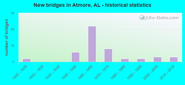
- New bridges - historical statistics
- 21920-1929
- 61950-1959
- 221960-1969
- 81970-1979
- 21980-1989
- 21990-1999
- 32000-2009
- 32010-2019
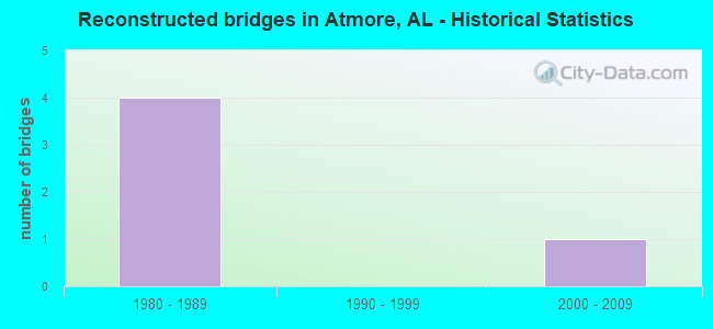
- Reconstructed bridges - Historical Statistics
- 41980-1989
- 01990-1999
- 12000-2009
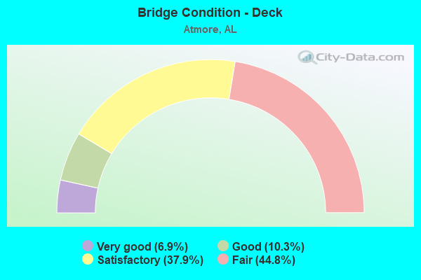
- Bridge Condition - Deck
- 6.9%Very good
- 10.3%Good
- 37.9%Satisfactory
- 44.8%Fair
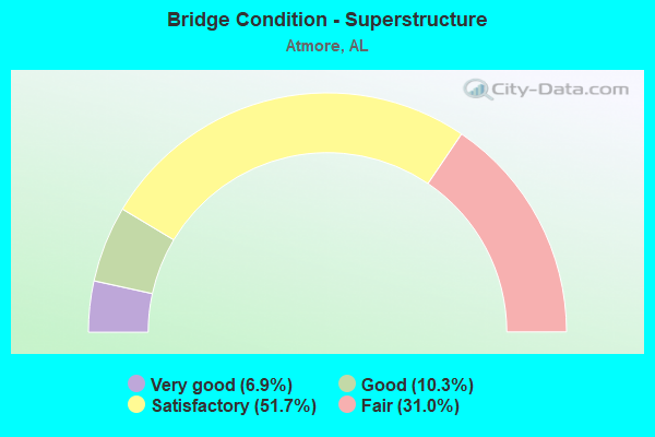
- Bridge Condition - Superstructure
- 6.9%Very good
- 10.3%Good
- 51.7%Satisfactory
- 31.0%Fair
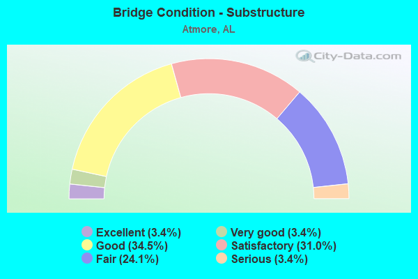
- Bridge Condition - Substructure
- 3.4%Excellent
- 3.4%Very good
- 34.5%Good
- 31.0%Satisfactory
- 24.1%Fair
- 3.4%Serious
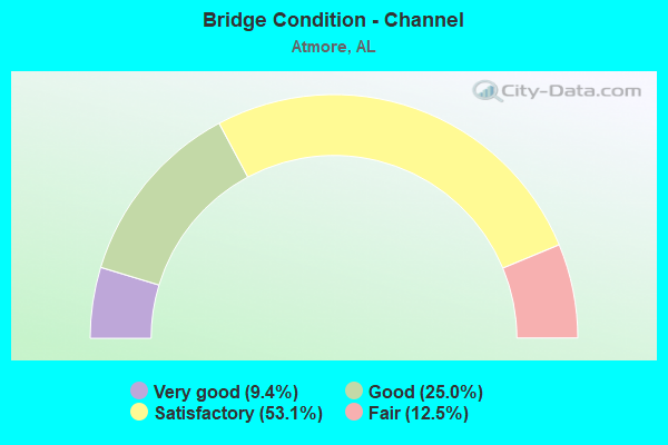
- Bridge Condition - Channel
- 9.4%Very good
- 25.0%Good
- 53.1%Satisfactory
- 12.5%Fair
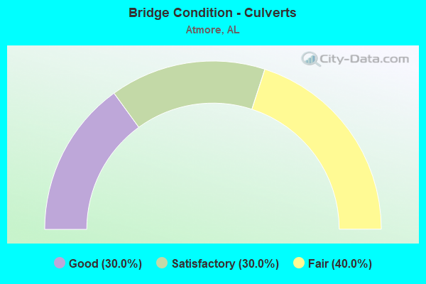
- Bridge Condition - Culverts
- 30.0%Good
- 30.0%Satisfactory
- 40.0%Fair
Find on map >> Show street view
Structure Number: 381, Location: 0.2 MI S SR 21 (Lat: 31.024114, Lng: -87.497044), Route carried "under" structure: US 31, Year Built: 1927, Structure Length: 0. m, Average Daily Traffic: 7,793 (year 2019), Truck Traffic: 3%, Features Intersected: US 31, Facility Carried by Structure: B & N RR
Minimum Vertical Clearance: 4.82m (15.81ft), Kilometerpoint: 66.319, Lanes under structure: 4, Material/Design: Steel, Design/Construction: Stringer/Multi-beam, Length of Maximum Span: 21.3m (69.9ft)
Find on map >> Show street view
Structure Number: 398, Location: 272' E HIGHLAND AVE (Lat: 31.023333, Lng: -87.503333), Route carried "under" structure: City street , Year Built: 1927, Structure Length: 0. m, Average Daily Traffic: 387 (year 2013), Truck Traffic: 1%, Features Intersected: W. OWENS ST, Facility Carried by Structure: BURL./NORTH. RR
Minimum Vertical Clearance: 3.71m (12.17ft), Kilometerpoint: 0.119, Lanes under structure: 2, Material/Design: Steel, Design/Construction: Girder and Floorbeam System, Length of Maximum Span: 12.5m (41.0ft)
Find on map >> Show street view
Structure Number: 648, Location: 4.4 MI N SR 21 (Lat: 31.143483, Lng: -87.409900), Route carried "under" structure: Interstate 65, Year Built: 1959, Structure Length: 0. m, Average Daily Traffic: 22,777 (year 2019), Truck Traffic: 24%, Features Intersected: I-65, Facility Carried by Structure: CO RD 45
Minimum Vertical Clearance: 5.65m (18.54ft), Kilometerpoint: 99.960, Lanes on structure: 2, Lanes under structure: 4, Material/Design: Concrete continuous, Design/Construction: Tee Beam, Length of Maximum Span: 20.1m (65.9ft)
Find on map >> Show street view
Structure Number: 8179, Location: 5.7 MI N BALDWIN CO LINE (Lat: 31.084189, Lng: -87.535078), Route carried "under" structure: Interstate 65, Year Built: 1964, Structure Length: 0. m, Average Daily Traffic: 23,939 (year 2019), Truck Traffic: 19%, Features Intersected: I-65, Facility Carried by Structure: CO RD 1
Minimum Vertical Clearance: 5.12m (16.80ft), Kilometerpoint: 86.233, Lanes on structure: 2, Lanes under structure: 4, Material/Design: Concrete continuous, Design/Construction: Tee Beam, Length of Maximum Span: 25.9m (85.0ft)
Find on map >> Show street view
Structure Number: 818, Location: 6.3 MI N BALD CO LINE (Lat: 31.089278, Lng: -87.527333), Route carried "under" structure: County highway , Year Built: 1964, Structure Length: 0. m, Average Daily Traffic: 177 (year 2019), Truck Traffic: 1%, Features Intersected: AGR RR * CO RD ATMORE, Facility Carried by Structure: I-65 SB
Minimum Vertical Clearance: 6.96m (22.83ft), Kilometerpoint: 0.000, Lanes on structure: 2, Lanes under structure: 2, Material/Design: Steel, Design/Construction: Stringer/Multi-beam, Length of Maximum Span: 21.6m (70.9ft)
Find on map >> Show street view
Structure Number: 8181, Location: 6.3 MI N BALD CO LINE (Lat: 31.088889, Lng: -87.527028), Route carried "under" structure: County highway , Year Built: 1964, Structure Length: 0. m, Average Daily Traffic: 169 (year 2019), Truck Traffic: 1%, Features Intersected: AGR RR * CO RD ATMORE, Facility Carried by Structure: I-65 NB
Minimum Vertical Clearance: 7.03m (23.06ft), Kilometerpoint: 87.146, Lanes on structure: 2, Lanes under structure: 2, Material/Design: Steel, Design/Construction: Stringer/Multi-beam, Length of Maximum Span: 21.6m (70.9ft)
Find on map >> Show street view
Structure Number: 8185, Location: 0.9 MI S SR 21 (Lat: 31.107356, Lng: -87.488181), Route carried "under" structure: Interstate 65, Year Built: 1964, Structure Length: 0. m, Average Daily Traffic: 11,969 (year 2019), Truck Traffic: 19%, Features Intersected: I-65, Facility Carried by Structure: CO RD 14
Minimum Vertical Clearance: 4.98m (16.34ft), Kilometerpoint: 91.419, Lanes on structure: 2, Lanes under structure: 4, Material/Design: Concrete continuous, Design/Construction: Tee Beam, Length of Maximum Span: 23.8m (78.1ft)
Find on map >> Show street view
Structure Number: 8186, Location: JCT I-65 * SR 21 (Lat: 31.110631, Lng: -87.474450), Route carried "under" structure: State highway 21, Year Built: 1964, Structure Length: 0. m, Average Daily Traffic: 5,892 (year 2019), Truck Traffic: 7%, Features Intersected: SR 21, Facility Carried by Structure: I-65 SB
Minimum Vertical Clearance: 4.89m (16.04ft), Kilometerpoint: 13.023, Lanes on structure: 2, Lanes under structure: 4, Material/Design: Concrete continuous, Design/Construction: Tee Beam, Length of Maximum Span: 27.4m (89.9ft)
Find on map >> Show street view
Structure Number: 8187, Location: JCT I-65 * SR 21 (Lat: 31.110389, Lng: -87.474558), Route carried "under" structure: State highway 21, Year Built: 1964, Structure Length: 0. m, Average Daily Traffic: 5,892 (year 2019), Truck Traffic: 7%, Features Intersected: SR 21, Facility Carried by Structure: I-65 NB
Minimum Vertical Clearance: 4.86m (15.94ft), Kilometerpoint: 13.023, Lanes on structure: 2, Lanes under structure: 4, Material/Design: Concrete continuous, Design/Construction: Tee Beam, Length of Maximum Span: 27.4m (89.9ft)