Bridge Statistics for Auburn Hills, Michigan (MI)
Condition, Traffic, Stress, Structural Evaluation, Project Costs
- National Bridge Inventory (NBI) Statistics
- 74Number of bridges
- 827ft / 252mTotal length
- $611,000Total costs
- 3,318,987Total average daily traffic
- 167,938Total average daily truck traffic
- National Bridge Inventory (NBI) Registered Bridges for Auburn Hills
- No street view available for this location
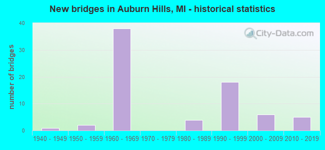
- New bridges - historical statistics
- 11940-1949
- 21950-1959
- 381960-1969
- 41980-1989
- 181990-1999
- 62000-2009
- 52010-2019
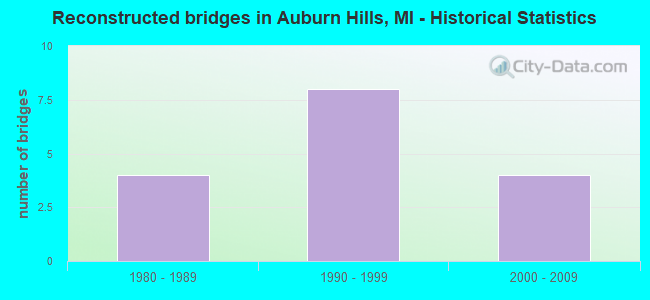
- Reconstructed bridges - Historical Statistics
- 41980-1989
- 81990-1999
- 42000-2009
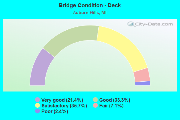
- Bridge Condition - Deck
- 21.4%Very good
- 33.3%Good
- 35.7%Satisfactory
- 7.1%Fair
- 2.4%Poor
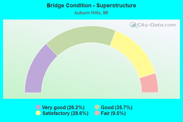
- Bridge Condition - Superstructure
- 26.2%Very good
- 35.7%Good
- 28.6%Satisfactory
- 9.5%Fair
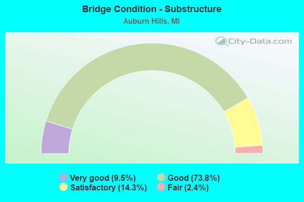
- Bridge Condition - Substructure
- 9.5%Very good
- 73.8%Good
- 14.3%Satisfactory
- 2.4%Fair
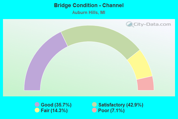
- Bridge Condition - Channel
- 35.7%Good
- 42.9%Satisfactory
- 14.3%Fair
- 7.1%Poor
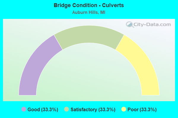
- Bridge Condition - Culverts
- 33.3%Good
- 33.3%Satisfactory
- 33.3%Poor
Find on map >> Show street view
Structure Number: 12687, Location: BET SQUIRREL AND ADAMS (Lat: 42.646800, Lng: -83.212450), Route carried "on" structure: City street 2059, Year Built: 1989, Status: Open, Structure Length: 1.95m (6.40ft), Average Daily Traffic: 6,000 (year 0000), Truck Traffic: 5%, Average Future Daily Traffic: 9,300 (year 2005), Design Load: HS 20, Features Intersected: CLINTON RIVER, Facility Carried by Structure: HAMLIN ROAD WBOUND
Minimum Vertical Clearance: 30.48m (100.00ft), Kilometerpoint: 0.568, Lanes on structure: 2, Owner: City or Municipal Highway Agency, Approaching Roadway Width: 8.5m (27.9ft), Skew: 10 degrees, Material/Design: Prestressed concrete, Design/Construction: Box Beam or Girders - Multiple, Number Of Spans In Main Unit: 1, Length of Maximum Span: 19.2m (63.0ft), Curb or Sidewalk Widths: Left: 0.0m, Right: 2.5m (8.2ft), Curb-To-Curb Width: 8.2m (26.9ft), Out-to-Out Width: 12.2m (40.0ft)
Condition: Deck: Good, Superstructure: Good, Substructure: Good, Channel: Satisfactory, Operating Rating: 97.2 metric tons, Method Used To Determine Operating Rating: Load Factor (LF) rating reported by rating factor (RF) method using MS18 loading, Inventory Rating: 63.8 metric tons, Method Used To Determine Inventory Rating: Load Factor (LF) rating reported by rating factor (RF) method using MS18 loading, Structural Evaluation: Better than present minimum criteria, Deck Geometry: High priority of corrective action, Waterway Adequacy: Better than present minimum criteria, Approach Roadway Alignment: Better than present minimum criteria, Designated Inspection Frequency: Every 24 months, Inspection Date: October 2020, Deck Structure Type: Concrete Precast Panels, Wearing Surface/Protective System: Wearing Surface: Monolithic Concrete, Membrane: Built-up, Deck Protection: Other
Find on map >> Show street view
Structure Number: 12831, Location: PONTIAC TWP SEC 25 (Lat: 42.643392, Lng: -83.220025), Route carried "on" structure: City street , Year Built: 1999, Status: Open, Structure Length: 10.97m (35.99ft), Average Daily Traffic: 9,820 (year 1997), Truck Traffic: 3%, Average Future Daily Traffic: 24,300 (year 2015), Design Load: HS 20, Features Intersected: M-59, Facility Carried by Structure: SQUIRREL RD SB
Minimum Vertical Clearance: 30.48m (100.00ft), Kilometerpoint: 1.062, Lanes on structure: 3, Lanes under structure: 6, Owner: State Highway Agency, Approaching Roadway Width: 15.5m (50.9ft), Material/Design: Prestressed concrete, Design/Construction: Box Beam or Girders - Multiple, Number Of Spans In Main Unit: 4, Length of Maximum Span: 42.1m (138.1ft), Curb or Sidewalk Widths: Left: 0.0m, Right: 2.4m (7.9ft), Curb-To-Curb Width: 15.5m (50.9ft), Out-to-Out Width: 19.3m (63.3ft)
Condition: Deck: Satisfactory, Superstructure: Fair, Substructure: Good, Operating Rating: 75.8 metric tons, Method Used To Determine Operating Rating: Load Factor (LF) rating reported by rating factor (RF) method using MS18 loading, Inventory Rating: 26.9 metric tons, Method Used To Determine Inventory Rating: Load Factor (LF) rating reported by rating factor (RF) method using MS18 loading, Structural Evaluation: Somewhat better than minimum adequacy, Deck Geometry: Equal to present minimum criteria, Underclear: Better than present minimum criteria, Approach Roadway Alignment: Equal to present desirable criteria, Designated Inspection Frequency: Every 24 months, Inspection Date: September 2020, Deck Structure Type: Concrete Cast-file-Place, Wearing Surface/Protective System: Wearing Surface: Monolithic Concrete, Deck Protection: Epoxy Coated Reinforcing
Find on map >> Show street view
Structure Number: 13196, Location: 2.0 MI N OF M-59 (Lat: 42.669553, Lng: -83.241361), Route carried "on" structure: Interstate 75, Year Built: 1963, Year Reconstructed: 1989, Status: Open, Structure Length: 3.96m (12.99ft), Average Daily Traffic: 56,400 (year 2019), Truck Traffic: 6%, Average Future Daily Traffic: 59,900 (year 2039), Design Load: HS 20+Mod, Features Intersected: PONTIAC ROAD
Minimum Vertical Clearance: 30.48m (100.00ft), Kilometerpoint: 33.242, Lanes on structure: 5, Lanes under structure: 2, Base Highway Network: Yes (Inventory Route: 64, Subroute: 6), Owner: State Highway Agency, Approaching Roadway Width: 30.1m (98.8ft), Skew: 30 degrees, Material/Design: Prestressed concrete, Design/Construction: Stringer/Multi-beam, Number Of Spans In Main Unit: 3, Length of Maximum Span: 19.1m (62.7ft), Curb-To-Curb Width: 29.4m (96.5ft), Out-to-Out Width: 31.1m (102.0ft)
Condition: Deck: Good, Superstructure: Good, Substructure: Good, Operating Rating: 63.4 metric tons, Method Used To Determine Operating Rating: Load Factor (LF), Inventory Rating: 38.0 metric tons, Method Used To Determine Inventory Rating: Load Factor (LF), Structural Evaluation: Better than present minimum criteria, Deck Geometry: Superior to present desirable criteria, Underclear: Equal to present minimum criteria, Approach Roadway Alignment: Equal to present desirable criteria, Designated Inspection Frequency: Every 24 months, Inspection Date: July 2021, Deck Structure Type: Concrete Cast-file-Place, Wearing Surface/Protective System: Deck Protection: Epoxy Coated Reinforcing
Find on map >> Show street view
Structure Number: 13198, Location: 1.6 MI N OF M-59 (Lat: 42.665750, Lng: -83.241189), Route carried "on" structure: City street 2059, Year Built: 2015, Status: Open, Structure Length: 6.98m (22.90ft), Average Daily Traffic: 24,399 (year 1997), Truck Traffic: 3%, Average Future Daily Traffic: 28,059 (year 2017), Design Load: Greater than HL93, Features Intersected: I-75, Facility Carried by Structure: UNIVERSITY DRIVE
Minimum Vertical Clearance: 30+ m (98+ ft), Kilometerpoint: 5.250, Lanes on structure: 4, Lanes under structure: 9, Base Highway Network: Yes (Inventory Route: 62, Subroute: 1), Owner: State Highway Agency, Approaching Roadway Width: 19.5m (64.0ft), Skew: 32 degrees, Material/Design: Prestressed concrete, Design/Construction: Stringer/Multi-beam, Number Of Spans In Main Unit: 2, Length of Maximum Span: 35.8m (117.5ft), Curb or Sidewalk Widths: Left: 0.0m, Right: 4.3m (14.1ft), Curb-To-Curb Width: 19.5m (64.0ft), Out-to-Out Width: 25.7m (84.3ft)
Condition: Deck: Very good, Superstructure: Very good, Substructure: Very good, Operating Rating: 53.8 metric tons, Method Used To Determine Operating Rating: Load and Resistance Factor Rating (LRFR) rating reported by rating factor(RF) method using HL-93 loadings, Inventory Rating: 33.4 metric tons, Method Used To Determine Inventory Rating: Load and Resistance Factor Rating (LRFR) rating reported by rating factor(RF) method using HL-93 loadings, Structural Evaluation: Equal to present desirable criteria, Deck Geometry: Better than present minimum criteria, Underclear: Somewhat better than minimum adequacy, Designated Inspection Frequency: Every 24 months, Inspection Date: December 2021, Deck Structure Type: Concrete Cast-file-Place, Wearing Surface/Protective System: Wearing Surface: Monolithic Concrete, Deck Protection: Epoxy Coated Reinforcing
Find on map >> Show street view
Structure Number: 13595, Location: IN SUBDIVSION SEC 21 (Lat: 42.750556, Lng: -83.293333), Route carried "on" structure: County highway , Year Built: 1985, Status: Open, Structure Length: 1.22m (4.00ft), Average Daily Traffic: 500 (year 2010), Average Future Daily Traffic: 545 (year 2030), Design Load: HS 20, Features Intersected: VOORHEIS LAKE, Facility Carried by Structure: CEDAR KEY DRIVE
Minimum Vertical Clearance: 30.48m (100.00ft), Kilometerpoint: 1.275, Lanes on structure: 2, Owner: County Highway Agency, Approaching Roadway Width: 8.5m (27.9ft), Material/Design: Steel, Design/Construction: Culvert, Number Of Spans In Main Unit: 3, Length of Maximum Span: 3.0m (9.8ft), Curb-To-Curb Width: 8.5m (27.9ft), Out-to-Out Width: 15.8m (51.8ft)
Condition: Channel: Poor, Culverts: Poor, Operating Rating: 97.2 metric tons, Method Used To Determine Operating Rating: Load Factor (LF) rating reported by rating factor (RF) method using MS18 loading, Inventory Rating: 97.2 metric tons, Method Used To Determine Inventory Rating: Load Factor (LF) rating reported by rating factor (RF) method using MS18 loading, Structural Evaluation: Meets minimum limits, Deck Geometry: Somewhat better than minimum adequacy, Waterway Adequacy: Equal to present desirable criteria, Approach Roadway Alignment: Equal to present desirable criteria, Designated Inspection Frequency: Every 24 months, Inspection Date: July 2020, Wearing Surface/Protective System: Wearing Surface: Bituminous
Find on map >> Show street view
Structure Number: 14037, Location: ORION TWP SEC 19 (Lat: 42.740917, Lng: -83.316556), Route carried "on" structure: County highway , Year Built: 1996, Status: Open, Structure Length: 0.69m (2.26ft), Average Daily Traffic: 500 (year 2015), Truck Traffic: 2%, Average Future Daily Traffic: 743 (year 2035), Features Intersected: SASHABAW CREEK, Facility Carried by Structure: SHADOW CREEK BLVD
Minimum Vertical Clearance: 30.48m (100.00ft), Kilometerpoint: 0.000, Lanes on structure: 4, Owner: County Highway Agency, Approaching Roadway Width: 13.4m (44.0ft), Skew: 34 degrees, Material/Design: Steel, Design/Construction: Culvert, Number Of Spans In Main Unit: 2, Length of Maximum Span: 3.0m (9.8ft), Curb or Sidewalk Widths: Left: 2.7m (8.9ft), Right: 0.0m, Curb-To-Curb Width: 13.4m (44.0ft), Out-to-Out Width: 67.1m (220.1ft)
Condition: Channel: Satisfactory, Culverts: Good, Operating Rating: 56.4 metric tons, Method Used To Determine Operating Rating: Load Factor (LF) rating reported by rating factor (RF) method using MS18 loading, Inventory Rating: 33.7 metric tons, Method Used To Determine Inventory Rating: Load Factor (LF) rating reported by rating factor (RF) method using MS18 loading, Structural Evaluation: Better than present minimum criteria, Deck Geometry: High priority of replacement, Waterway Adequacy: Better than present minimum criteria, Approach Roadway Alignment: Equal to present desirable criteria, Designated Inspection Frequency: Every 24 months, Inspection Date: October 2021, Wearing Surface/Protective System: Wearing Surface: Bituminous
Find on map >> Show street view
Structure Number: 14272, Location: ORION TWP SEC 29 (Lat: 42.725000, Lng: -83.299256), Route carried "on" structure: County highway , Year Built: 1998, Status: Open, Structure Length: 0.67m (2.20ft), Average Daily Traffic: 500 (year 2018), Average Future Daily Traffic: 600 (year 2038), Design Load: HS 20, Features Intersected: BROWN DRAIN, Facility Carried by Structure: MUELLER RD
Minimum Vertical Clearance: 30.48m (100.00ft), Kilometerpoint: 0.185, Lanes on structure: 2, Owner: County Highway Agency, Approaching Roadway Width: 8.5m (27.9ft), Material/Design: Concrete, Design/Construction: Culvert, Number Of Spans In Main Unit: 3, Length of Maximum Span: 2.2m (7.2ft), Curb-To-Curb Width: 8.5m (27.9ft), Out-to-Out Width: 23.8m (78.1ft)
Condition: Channel: Satisfactory, Culverts: Satisfactory, Operating Rating: 54.5 metric tons, Method Used To Determine Operating Rating: Field evaluation and documented engineering judgment, Inventory Rating: 32.7 metric tons, Method Used To Determine Inventory Rating: Field evaluation and documented engineering judgment, Structural Evaluation: Equal to present minimum criteria, Deck Geometry: Somewhat better than minimum adequacy, Waterway Adequacy: Equal to present minimum criteria, Approach Roadway Alignment: Equal to present desirable criteria, Designated Inspection Frequency: Every 24 months, Inspection Date: July 2020, Wearing Surface/Protective System: Wearing Surface: Bituminous
Find on map >> Show street view
Structure Number: 784, Location: PONTIAC TWP SEC 25 (Lat: 42.643436, Lng: -83.219642), Route carried "under" structure: State highway 59, Year Built: 1999, Structure Length: 0. m, Average Daily Traffic: 81,056 (year 2007), Truck Traffic: 3%, Features Intersected: M-59, Facility Carried by Structure: SQUIRREL RD NB
Minimum Vertical Clearance: 6.63m (21.75ft), Kilometerpoint: 39.931, Lanes on structure: 3, Lanes under structure: 6, Material/Design: Prestressed concrete, Design/Construction: Box Beam or Girders - Multiple, Length of Maximum Span: 42.1m (138.1ft)
Find on map >> Show street view
Structure Number: 7999, Location: @ (M-59) E OF PONTIAC (Lat: 42.641744, Lng: -83.238242), Route carried "under" structure: State highway 59, Year Built: 1963, Structure Length: 0. m, Average Daily Traffic: 76,232 (year 2007), Truck Traffic: 3%, Features Intersected: M-59, Facility Carried by Structure: I-75 NB
Minimum Vertical Clearance: 4.67m (15.32ft), Kilometerpoint: 38.391, Lanes on structure: 3, Lanes under structure: 8, Material/Design: Steel, Design/Construction: Stringer/Multi-beam, Length of Maximum Span: 24.8m (81.4ft)
Find on map >> Show street view
Structure Number: 8, Location: EAST OF PONTIAC (M-59) (Lat: 42.641494, Lng: -83.238597), Route carried "under" structure: State highway 59, Year Built: 1963, Structure Length: 0. m, Average Daily Traffic: 38,730 (year 2007), Truck Traffic: 4%, Features Intersected: M-59, Facility Carried by Structure: I-75 SB
Minimum Vertical Clearance: 4.78m (15.68ft), Kilometerpoint: 38.362, Lanes on structure: 5, Lanes under structure: 8, Material/Design: Steel, Design/Construction: Stringer/Multi-beam, Length of Maximum Span: 24.8m (81.4ft)
Find on map >> Show street view
Structure Number: 8001, Location: 0.4 MI N.OF M-59 (Lat: 42.649333, Lng: -83.238100), Route carried "under" structure: Interstate 75, Year Built: 1990, Structure Length: 0. m, Average Daily Traffic: 150,290 (year 2007), Truck Traffic: 4%, Features Intersected: I-75, Facility Carried by Structure: FEATHERSTONE RD EB
Minimum Vertical Clearance: 6.12m (20.08ft), Kilometerpoint: 30.699, Lanes on structure: 2, Lanes under structure: 9, Material/Design: Prestressed concrete, Design/Construction: Stringer/Multi-beam, Length of Maximum Span: 33.5m (109.9ft)
Find on map >> Show street view
Structure Number: 8002, Location: 0.4 MI N. OF M-59 (Lat: 42.649328, Lng: -83.238453), Route carried "under" structure: Interstate 75, Year Built: 1990, Structure Length: 0. m, Average Daily Traffic: 150,290 (year 2007), Truck Traffic: 4%, Features Intersected: I-75, Facility Carried by Structure: FEATHERSTONE RD WB
Minimum Vertical Clearance: 6.35m (20.83ft), Kilometerpoint: 30.812, Lanes on structure: 2, Lanes under structure: 9, Material/Design: Prestressed concrete, Design/Construction: Stringer/Multi-beam, Length of Maximum Span: 33.5m (109.9ft)
Find on map >> Show street view
Structure Number: 8004, Location: 2.0 MI N OF M-59 (Lat: 42.670944, Lng: -83.241017), Route carried "under" structure: City street 2059, Year Built: 1963, Structure Length: 0. m, Average Daily Traffic: 3,100 (year 2009), Features Intersected: PONTIAC RD, Facility Carried by Structure: I-75 NB
Minimum Vertical Clearance: 4.42m (14.50ft), Kilometerpoint: 1.128, Lanes on structure: 5, Lanes under structure: 2, Material/Design: Prestressed concrete, Design/Construction: Stringer/Multi-beam, Length of Maximum Span: 19.2m (63.0ft)
Find on map >> Show street view
Structure Number: 8005, Location: 2.5 MI N OF M-59 (Lat: 42.678531, Lng: -83.241014), Route carried "under" structure: Interstate 75, Year Built: 2008, Structure Length: 0. m, Average Daily Traffic: 122,626 (year 2007), Truck Traffic: 4%, Features Intersected: I-75, Facility Carried by Structure: WALTON BLVD
Minimum Vertical Clearance: 5.31m (17.42ft), Kilometerpoint: 33.971, Lanes on structure: 5, Lanes under structure: 8, Material/Design: Prestressed concrete, Design/Construction: Box Beam or Girders - Single/Spread, Length of Maximum Span: 31.0m (101.7ft)
Find on map >> Show street view
Structure Number: 8006, Location: @ I-75 , M-24 (Lat: 42.683569, Lng: -83.243297), Route carried "under" structure: Business Interstate 75, Year Built: 1962, Structure Length: 0. m, Average Daily Traffic: 26,340 (year 2007), Truck Traffic: 2%, Features Intersected: I-75 BL & M-24
Minimum Vertical Clearance: 5.28m (17.32ft), Kilometerpoint: 0.457, Lanes on structure: 4, Lanes under structure: 6, Material/Design: Prestressed concrete, Design/Construction: Stringer/Multi-beam, Length of Maximum Span: 18.6m (61.0ft)
Find on map >> Show street view
Structure Number: 8007, Location: @ I-75 , M-24 (Lat: 42.683347, Lng: -83.243556), Route carried "under" structure: Business Interstate 75, Year Built: 1962, Structure Length: 0. m, Average Daily Traffic: 20,500 (year 2009), Truck Traffic: 32%, Features Intersected: M-24 & I-75 BL
Minimum Vertical Clearance: 5.23m (17.16ft), Kilometerpoint: 0.425, Lanes on structure: 4, Lanes under structure: 4, Material/Design: Prestressed concrete, Design/Construction: Stringer/Multi-beam, Length of Maximum Span: 18.6m (61.0ft)
Find on map >> Show street view
Structure Number: 8008, Location: @ M-24 (I-75 SB TO M-24) (Lat: 42.692044, Lng: -83.250936), Route carried "under" structure: Interstate 75, Year Built: 1962, Structure Length: 0. m, Average Daily Traffic: 122,626 (year 2007), Truck Traffic: 4%, Features Intersected: I-75, Facility Carried by Structure: M-24 CONN EB
Minimum Vertical Clearance: 5.11m (16.77ft), Kilometerpoint: 35.701, Lanes on structure: 1, Lanes under structure: 9, Material/Design: Steel, Design/Construction: Stringer/Multi-beam, Length of Maximum Span: 27.0m (88.6ft)
Find on map >> Show street view
Structure Number: 8009, Location: @ M-24 (M-24 CONN TO I-75 (Lat: 42.692172, Lng: -83.251047), Route carried "under" structure: Interstate 75, Year Built: 1962, Structure Length: 0. m, Average Daily Traffic: 122,626 (year 2007), Truck Traffic: 4%, Features Intersected: I-75, Facility Carried by Structure: M-24 CONN WB
Minimum Vertical Clearance: 5.05m (16.57ft), Kilometerpoint: 35.719, Lanes on structure: 1, Lanes under structure: 9, Material/Design: Steel, Design/Construction: Stringer/Multi-beam, Length of Maximum Span: 27.0m (88.6ft)
Find on map >> Show street view
Structure Number: 801, Location: @ M-24(I-75 CONN TO M-24) (Lat: 42.693114, Lng: -83.241681), Route carried "under" structure: State highway 24, Year Built: 1962, Structure Length: 0. m, Average Daily Traffic: 50,606 (year 2007), Truck Traffic: 5%, Features Intersected: M-24, Facility Carried by Structure: I-75 CONN EB
Minimum Vertical Clearance: 4.52m (14.83ft), Kilometerpoint: 1.579, Lanes on structure: 2, Lanes under structure: 6, Material/Design: Prestressed concrete, Design/Construction: Stringer/Multi-beam, Length of Maximum Span: 19.3m (63.3ft)
Find on map >> Show street view
Structure Number: 8011, Location: @ M-24(I-75 CONN TO I-75 (Lat: 42.693278, Lng: -83.241708), Route carried "under" structure: State highway 24, Year Built: 1962, Structure Length: 0. m, Average Daily Traffic: 50,606 (year 2007), Truck Traffic: 5%, Features Intersected: M-24, Facility Carried by Structure: I-75 CONN WB
Minimum Vertical Clearance: 4.65m (15.26ft), Kilometerpoint: 1.597, Lanes on structure: 1, Lanes under structure: 6, Material/Design: Prestressed concrete, Design/Construction: Stringer/Multi-beam, Length of Maximum Span: 19.3m (63.3ft)
Find on map >> Show street view
Structure Number: 8012, Location: 0.8 MI NW OF M-24 (Lat: 42.695822, Lng: -83.261847), Route carried "under" structure: Interstate 75, Year Built: 1962, Structure Length: 0. m, Average Daily Traffic: 99,082 (year 2007), Truck Traffic: 4%, Features Intersected: I-75, Facility Carried by Structure: GIDDINGS RD
Minimum Vertical Clearance: 6.32m (20.73ft), Kilometerpoint: 36.791, Lanes on structure: 2, Lanes under structure: 8, Material/Design: Prestressed concrete, Design/Construction: Stringer/Multi-beam, Length of Maximum Span: 22.6m (74.1ft)
Find on map >> Show street view
Structure Number: 8013, Location: 2.0 MI NW OF M-24 (JOSLYN (Lat: 42.701697, Lng: -83.284144), Route carried "under" structure: County highway 2059, Year Built: 1962, Structure Length: 0. m, Average Daily Traffic: 16,000 (year 1974), Features Intersected: JOSLYN RD, Facility Carried by Structure: I-75 NB
Minimum Vertical Clearance: 4.55m (14.93ft), Kilometerpoint: 5.609, Lanes on structure: 4, Lanes under structure: 4, Material/Design: Steel, Design/Construction: Stringer/Multi-beam, Length of Maximum Span: 30.5m (100.1ft)
Find on map >> Show street view
Structure Number: 8014, Location: 2.0 MI NW OF M-24 (JOSLYN (Lat: 42.701331, Lng: -83.283983), Route carried "under" structure: County highway 2059, Year Built: 1962, Structure Length: 0. m, Average Daily Traffic: 16,000 (year 0000), Features Intersected: JOSLYN RD, Facility Carried by Structure: I-75 SB
Minimum Vertical Clearance: 4.82m (15.81ft), Kilometerpoint: 5.567, Lanes on structure: 3, Lanes under structure: 4, Material/Design: Steel, Design/Construction: Stringer/Multi-beam, Length of Maximum Span: 30.5m (100.1ft)
Find on map >> Show street view
Structure Number: 8015, Location: 3.1 MI NW OF M-24 (Lat: 42.705181, Lng: -83.306733), Route carried "under" structure: Interstate 75, Year Built: 1993, Structure Length: 0. m, Average Daily Traffic: 92,116 (year 2007), Truck Traffic: 5%, Features Intersected: I-75, Facility Carried by Structure: NB BALDWIN RD
Minimum Vertical Clearance: 5.61m (18.41ft), Kilometerpoint: 40.745, Lanes on structure: 3, Lanes under structure: 8, Material/Design: Prestressed concrete, Design/Construction: Stringer/Multi-beam, Length of Maximum Span: 35.9m (117.8ft)
Find on map >> Show street view
Structure Number: 8016, Location: 4.1MI SE OF M-15 (Lat: 42.721142, Lng: -83.349311), Route carried "under" structure: County highway 2059, Year Built: 1962, Structure Length: 0. m, Average Daily Traffic: 4,060 (year 1974), Features Intersected: CLINTONVILLE RD, Facility Carried by Structure: I-75 NB
Minimum Vertical Clearance: 4.52m (14.83ft), Kilometerpoint: 3.817, Lanes on structure: 3, Lanes under structure: 2, Material/Design: Steel, Design/Construction: Stringer/Multi-beam, Length of Maximum Span: 17.8m (58.4ft)
Find on map >> Show street view
Structure Number: 8017, Location: 4.1 MI SE OF M-15 (Lat: 42.720778, Lng: -83.349300), Route carried "under" structure: County highway 2059, Year Built: 1962, Structure Length: 0. m, Average Daily Traffic: 4,060 (year 1974), Features Intersected: CLINTONVILLE RD, Facility Carried by Structure: I-75 SB
Minimum Vertical Clearance: 4.40m (14.44ft), Kilometerpoint: 3.777, Lanes on structure: 3, Lanes under structure: 2, Material/Design: Steel, Design/Construction: Stringer/Multi-beam, Length of Maximum Span: 17.8m (58.4ft)
Find on map >> Show street view
Structure Number: 8023, Location: I-75 @ CHRYSLER DR. (Lat: 42.651861, Lng: -83.238219), Route carried "under" structure: Interstate 75, Year Built: 1990, Structure Length: 0. m, Average Daily Traffic: 150,290 (year 2007), Truck Traffic: 4%, Features Intersected: I-75 RAMP B & I-75
Minimum Vertical Clearance: 5.43m (17.81ft), Kilometerpoint: 30.987, Lanes on structure: 2, Lanes under structure: 5, Material/Design: Steel continuous, Design/Construction: Stringer/Multi-beam, Length of Maximum Span: 35.1m (115.2ft)
Find on map >> Show street view
Structure Number: 8024, Location: I-75 @ CHRYSLER DR. (Lat: 42.655583, Lng: -83.239250), Route carried "under" structure: Interstate 75, Year Built: 1990, Structure Length: 0. m, Average Daily Traffic: 150,290 (year 2007), Truck Traffic: 4%, Features Intersected: I-75 RAMP C & I-75
Minimum Vertical Clearance: 5.13m (16.83ft), Kilometerpoint: 31.411, Lanes on structure: 1, Lanes under structure: 9, Material/Design: Steel continuous, Design/Construction: Stringer/Multi-beam, Length of Maximum Span: 34.7m (113.8ft)
Find on map >> Show street view
Structure Number: 8025, Location: 3.1 MI NW OF M-24 (Lat: 42.705181, Lng: -83.307053), Route carried "under" structure: Interstate 75, Year Built: 1993, Structure Length: 0. m, Average Daily Traffic: 85,740 (year 2007), Truck Traffic: 5%, Features Intersected: I-75, Facility Carried by Structure: SB BALDWIN RD
Minimum Vertical Clearance: 5.94m (19.49ft), Kilometerpoint: 40.771, Lanes on structure: 4, Lanes under structure: 8, Material/Design: Prestressed concrete, Design/Construction: Stringer/Multi-beam, Length of Maximum Span: 35.9m (117.8ft)
Find on map >> Show street view
Structure Number: 8086, Location: 1.5 MI S OF M-59 (Lat: 42.620331, Lng: -83.235389), Route carried "under" structure: Interstate 75, Year Built: 2001, Structure Length: 0. m, Average Daily Traffic: 129,500 (year 2012), Truck Traffic: 5%, Features Intersected: I-75, Facility Carried by Structure: SOUTH BLVD
Minimum Vertical Clearance: 5.72m (18.77ft), Kilometerpoint: 27.460, Lanes on structure: 2, Lanes under structure: 10, Material/Design: Steel continuous, Design/Construction: Stringer/Multi-beam, Length of Maximum Span: 49.0m (160.8ft)
Find on map >> Show street view
Structure Number: 8087, Location: 0.5 MI S OF M-59 (Lat: 42.634519, Lng: -83.238469), Route carried "under" structure: Alternate State highway 59, Year Built: 1964, Structure Length: 0. m, Average Daily Traffic: 13,000 (year 1995), Truck Traffic: 5%, Features Intersected: OLD M-59 (AUBURN RD), Facility Carried by Structure: I-75 NB
Minimum Vertical Clearance: 4.55m (14.93ft), Kilometerpoint: 4.337, Lanes on structure: 5, Lanes under structure: 2, Material/Design: Prestressed concrete, Design/Construction: Stringer/Multi-beam, Length of Maximum Span: 19.5m (64.0ft)
Find on map >> Show street view
Structure Number: 8088, Location: 0.5 MI S OF M-59 (Lat: 42.634581, Lng: -83.238825), Route carried "under" structure: Alternate State highway 59, Year Built: 1964, Structure Length: 0. m, Average Daily Traffic: 13,000 (year 1995), Truck Traffic: 5%, Features Intersected: OLD M-59 (AUBURN RD), Facility Carried by Structure: I-75 SB
Minimum Vertical Clearance: 4.47m (14.67ft), Kilometerpoint: 4.307, Lanes on structure: 4, Lanes under structure: 4, Material/Design: Prestressed concrete, Design/Construction: Stringer/Multi-beam, Length of Maximum Span: 19.5m (64.0ft)
Find on map >> Show street view
Structure Number: 12831, Location: PONTIAC TWP SEC 25 (Lat: 42.643392, Lng: -83.220025), Route carried "under" structure: State highway 59, Year Built: 1999, Structure Length: 0. m, Average Daily Traffic: 81,056 (year 2007), Truck Traffic: 3%, Features Intersected: M-59, Facility Carried by Structure: SQUIRREL RD SB
Minimum Vertical Clearance: 6.20m (20.34ft), Kilometerpoint: 39.899, Lanes on structure: 3, Lanes under structure: 6, Material/Design: Prestressed concrete, Design/Construction: Box Beam or Girders - Multiple, Length of Maximum Span: 42.1m (138.1ft)
Find on map >> Show street view
Structure Number: 12875, Location: AUBURN RD @ I-75 (Lat: 42.628903, Lng: -83.238269), Route carried "under" structure: Interstate 75, Year Built: 2002, Structure Length: 0. m, Average Daily Traffic: 141,754 (year 2007), Truck Traffic: 10%, Features Intersected: I-75, Facility Carried by Structure: CLINTON RIVERTRAIL
Minimum Vertical Clearance: 5.77m (18.93ft), Kilometerpoint: 4.337, Lanes under structure: 8, Material/Design: Prestressed concrete, Design/Construction: Stringer/Multi-beam, Length of Maximum Span: 43.9m (144.0ft)
Find on map >> Show street view
Structure Number: 13196, Location: 2.0 MI N OF M-59 (Lat: 42.669553, Lng: -83.241361), Route carried "under" structure: City street 2059, Year Built: 1963, Structure Length: 0. m, Average Daily Traffic: 3,100 (year 2009), Features Intersected: PONTIAC ROAD, Facility Carried by Structure: I-75 SB
Minimum Vertical Clearance: 4.42m (14.50ft), Kilometerpoint: 1.099, Lanes on structure: 5, Lanes under structure: 2, Material/Design: Prestressed concrete, Design/Construction: Stringer/Multi-beam, Length of Maximum Span: 19.1m (62.7ft)
Find on map >> Show street view
Structure Number: 13198, Location: 1.6 MI N OF M-59 (Lat: 42.665750, Lng: -83.241189), Route carried "under" structure: Interstate 75, Year Built: 2015, Structure Length: 0. m, Average Daily Traffic: 139,794 (year 2007), Truck Traffic: 7%, Features Intersected: I-75, Facility Carried by Structure: UNIVERSITY DRIVE
Minimum Vertical Clearance: 5.18m (16.99ft), Kilometerpoint: 32.563, Lanes on structure: 4, Lanes under structure: 9, Material/Design: Prestressed concrete, Design/Construction: Stringer/Multi-beam, Length of Maximum Span: 35.8m (117.5ft)