Bridge Statistics for Avoca, New York (NY)
Condition, Traffic, Stress, Structural Evaluation, Project Costs
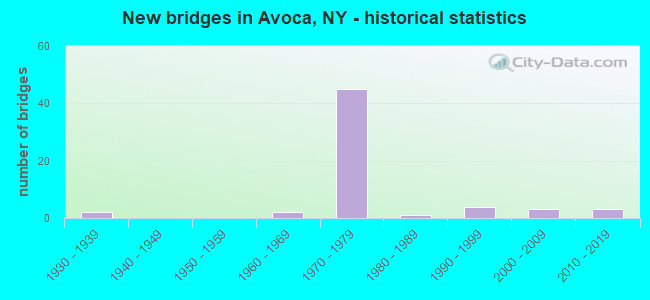
- New bridges - historical statistics
- 21930-1939
- 21960-1969
- 451970-1979
- 11980-1989
- 41990-1999
- 32000-2009
- 32010-2019

- Reconstructed bridges - Historical Statistics
- 31980-1989
- 71990-1999
- 82000-2009
- 32010-2019


- Bridge Condition - Deck
- 6.8%Excellent
- 13.6%Very good
- 11.4%Good
- 34.1%Satisfactory
- 34.1%Fair

- Bridge Condition - Superstructure
- 9.1%Excellent
- 9.1%Very good
- 25.0%Good
- 34.1%Satisfactory
- 22.7%Fair

- Bridge Condition - Substructure
- 9.1%Excellent
- 2.3%Very good
- 34.1%Good
- 31.8%Satisfactory
- 22.7%Fair

- Bridge Condition - Channel
- 6.5%Very good
- 41.9%Good
- 35.5%Satisfactory
- 16.1%Fair

- Bridge Condition - Culverts
- 33.3%Excellent
- 33.3%Good
- 33.3%Satisfactory
Find on map >> Show street view
Structure Number: 101137, Location: 0.6 MI NW JCT RTS 17 +415 (Lat: 42.394933, Lng: -77.405314), Route carried "on" structure: State highway 415, Year Built: 2019, Status: Open, Structure Length: 1.98m (6.50ft), Average Daily Traffic: 2,076 (year 2020), Truck Traffic: 7%, Average Future Daily Traffic: 2,165 (year 2040), Design Load: HL 93, Features Intersected: SALMON CREEK
Minimum Vertical Clearance: 30+ m (98+ ft), Kilometerpoint: 43.363, Lanes on structure: 2, Base Highway Network: Yes, Owner: State Highway Agency, Approaching Roadway Width: 12.2m (40.0ft), Skew: 3 degrees, Material/Design: Steel, Design/Construction: Stringer/Multi-beam, Number Of Spans In Main Unit: 1, Length of Maximum Span: 19.5m (64.0ft), Curb-To-Curb Width: 12.2m (40.0ft), Out-to-Out Width: 13.2m (43.3ft)
Condition: Deck: Excellent, Superstructure: Excellent, Substructure: Excellent, Channel: Very good, Operating Rating: 76.2 metric tons, Method Used To Determine Operating Rating: Load Factor (LF), Inventory Rating: 45.4 metric tons, Method Used To Determine Inventory Rating: Load Factor (LF), Structural Evaluation: Superior to present desirable criteria, Deck Geometry: Equal to present minimum criteria, Waterway Adequacy: Meets minimum limits, Approach Roadway Alignment: Equal to present desirable criteria, Length Of Structure Improvement: 1.98m (6.50ft), Designated Inspection Frequency: Every 24 months, Inspection Date: September 2021, Bridge Improvement Cost: $889,000, Roadway Improvement Cost: $521,000, Total Project Cost: $1,410,000 ( Estimate for 2021), Deck Structure Type: Concrete Cast-file-Place, Wearing Surface/Protective System: Wearing Surface: Monolithic Concrete, Deck Protection: Epoxy Coated Reinforcing
Find on map >> Show street view
Structure Number: 101138, Location: JCT SR 415 & COHOCTON RIV (Lat: 42.392258, Lng: -77.400919), Route carried "on" structure: State highway 415, Year Built: 1991, Status: Open, Structure Length: 11.19m (36.71ft), Average Daily Traffic: 2,076 (year 2020), Truck Traffic: 7%, Average Future Daily Traffic: 2,165 (year 2040), Design Load: HS 20, Features Intersected: COHOCTON RIVER
Minimum Vertical Clearance: 30+ m (98+ ft), Kilometerpoint: 42.815, Lanes on structure: 2, Base Highway Network: Yes, Owner: State Highway Agency, Approaching Roadway Width: 12.2m (40.0ft), Material/Design: Steel continuous, Design/Construction: Stringer/Multi-beam, Number Of Spans In Main Unit: 3, Length of Maximum Span: 44.1m (144.7ft), Curb-To-Curb Width: 12.2m (40.0ft), Out-to-Out Width: 12.8m (42.0ft)
Condition: Deck: Fair, Superstructure: Satisfactory, Substructure: Fair, Channel: Satisfactory, Operating Rating: 53.5 metric tons, Method Used To Determine Operating Rating: Load Factor (LF), Inventory Rating: 39.0 metric tons, Method Used To Determine Inventory Rating: Load Factor (LF), Structural Evaluation: Somewhat better than minimum adequacy, Deck Geometry: Equal to present minimum criteria, Waterway Adequacy: Somewhat better than minimum adequacy, Approach Roadway Alignment: Equal to present desirable criteria, Length Of Structure Improvement: 11.18m (36.68ft), Designated Inspection Frequency: Every 24 months, Inspection Date: April 2020, Bridge Improvement Cost: $3,570,000, Roadway Improvement Cost: $2,091,000, Total Project Cost: $5,661,000 ( Estimate for 2021), Deck Structure Type: Concrete Cast-file-Place, Wearing Surface/Protective System: Wearing Surface: Epoxy Overlay, Deck Protection: Epoxy Coated Reinforcing
Find on map >> Show street view
Structure Number: 101139, Location: .3 MILE NW OF AVOCA (Lat: 42.411597, Lng: -77.426864), Route carried "on" structure: State highway 415, Year Built: 2008, Status: Open, Structure Length: 9.05m (29.69ft), Average Daily Traffic: 1,526 (year 2020), Truck Traffic: 8%, Average Future Daily Traffic: 1,591 (year 2040), Design Load: H 20, Features Intersected: COHOCTON RIVER
Minimum Vertical Clearance: 30+ m (98+ ft), Kilometerpoint: 46.098, Lanes on structure: 2, Base Highway Network: Yes, Owner: State Highway Agency, Maintenance Responsibility: Private, Approaching Roadway Width: 12.2m (40.0ft), Skew: 2 degrees, Material/Design: Steel continuous, Design/Construction: Stringer/Multi-beam, Number Of Spans In Main Unit: 3, Length of Maximum Span: 36.0m (118.1ft), Curb-To-Curb Width: 12.0m (39.4ft), Out-to-Out Width: 13.0m (42.7ft)
Condition: Deck: Satisfactory, Superstructure: Good, Substructure: Good, Channel: Very good, Operating Rating: 75.0 metric tons, Method Used To Determine Operating Rating: Load Factor (LF), Inventory Rating: 44.0 metric tons, Method Used To Determine Inventory Rating: Load Factor (LF), Structural Evaluation: Better than present minimum criteria, Deck Geometry: Equal to present minimum criteria, Waterway Adequacy: Equal to present desirable criteria, Approach Roadway Alignment: Equal to present desirable criteria, Length Of Structure Improvement: 9.05m (29.69ft), Designated Inspection Frequency: Every 24 months, Inspection Date: September 2020, Bridge Improvement Cost: $2,943,000, Roadway Improvement Cost: $1,724,000, Total Project Cost: $4,667,000 ( Estimate for 2021), Deck Structure Type: Concrete Cast-file-Place, Wearing Surface/Protective System: Wearing Surface: Integral Concrete, Deck Protection: Epoxy Coated Reinforcing
Find on map >> Show street view
Structure Number: 10114, Location: 0.5 MI S OF WALLACE (Lat: 42.433233, Lng: -77.456167), Route carried "on" structure: State highway 415, Year Built: 1961, Year Reconstructed: 2013, Status: Open, Structure Length: 2.44m (8.01ft), Average Daily Traffic: 1,327 (year 2017), Truck Traffic: 11%, Average Future Daily Traffic: 1,384 (year 2040), Design Load: HS 20+Mod, Features Intersected: NEIL CREEK
Minimum Vertical Clearance: 30+ m (98+ ft), Kilometerpoint: 49.541, Lanes on structure: 2, Base Highway Network: Yes, Owner: State Highway Agency, Approaching Roadway Width: 13.4m (44.0ft), Skew: 2 degrees, Material/Design: Prestressed concrete, Design/Construction: Tee Beam, Number Of Spans In Main Unit: 1, Length of Maximum Span: 22.8m (74.8ft), Curb-To-Curb Width: 12.2m (40.0ft), Out-to-Out Width: 13.7m (44.9ft)
Condition: Deck: Good, Superstructure: Good, Substructure: Good, Channel: Satisfactory, Operating Rating: 68.9 metric tons, Method Used To Determine Operating Rating: Load Factor (LF), Inventory Rating: 35.4 metric tons, Method Used To Determine Inventory Rating: Load Factor (LF), Structural Evaluation: Better than present minimum criteria, Deck Geometry: Better than present minimum criteria, Waterway Adequacy: Equal to present minimum criteria, Approach Roadway Alignment: Equal to present desirable criteria, Length Of Structure Improvement: 2.43m (7.97ft), Designated Inspection Frequency: Every 24 months, Inspection Date: November 2021, Bridge Improvement Cost: $1,260,000, Roadway Improvement Cost: $738,000, Total Project Cost: $1,998,000 ( Estimate for 2021), Deck Structure Type: Concrete Cast-file-Place, Wearing Surface/Protective System: Wearing Surface: Integral Concrete, Deck Protection: Epoxy Coated Reinforcing
Find on map >> Show street view
Structure Number: 101141, Location: 0.1 MI S OF WALLACE (Lat: 42.437572, Lng: -77.458156), Route carried "on" structure: State highway 415, Year Built: 2003, Status: Open, Structure Length: 3.47m (11.38ft), Average Daily Traffic: 1,327 (year 2017), Truck Traffic: 11%, Average Future Daily Traffic: 1,384 (year 2040), Design Load: HS 25 or greater, Features Intersected: COHOCTON RIVER
Minimum Vertical Clearance: 30+ m (98+ ft), Kilometerpoint: 50.072, Lanes on structure: 2, Base Highway Network: Yes, Owner: State Highway Agency, Approaching Roadway Width: 10.1m (33.1ft), Skew: 3 degrees, Material/Design: Prestressed concrete, Design/Construction: Box Beam or Girders - Multiple, Number Of Spans In Main Unit: 1, Length of Maximum Span: 33.5m (109.9ft), Curb-To-Curb Width: 10.7m (35.1ft), Out-to-Out Width: 11.7m (38.4ft)
Condition: Deck: Satisfactory, Superstructure: Satisfactory, Substructure: Good, Channel: Good, Operating Rating: 76.2 metric tons, Method Used To Determine Operating Rating: Load Factor (LF), Inventory Rating: 42.6 metric tons, Method Used To Determine Inventory Rating: Load Factor (LF), Structural Evaluation: Equal to present minimum criteria, Deck Geometry: Equal to present minimum criteria, Waterway Adequacy: Equal to present minimum criteria, Approach Roadway Alignment: Equal to present desirable criteria, Length Of Structure Improvement: 3.47m (11.38ft), Designated Inspection Frequency: Every 24 months, Inspection Date: October 2021, Bridge Improvement Cost: $1,004,000, Roadway Improvement Cost: $588,000, Total Project Cost: $1,592,000 ( Estimate for 2021), Deck Structure Type: Concrete Cast-file-Place, Wearing Surface/Protective System: Wearing Surface: Bituminous, Membrane: Other, Deck Protection: Epoxy Coated Reinforcing
Find on map >> Show street view
Structure Number: 101142, Location: N END OF WALLACE RTE 415 (Lat: 42.447531, Lng: -77.460478), Route carried "on" structure: State highway 415, Year Built: 1970, Status: Open, Structure Length: 2.87m (9.42ft), Average Daily Traffic: 1,327 (year 2017), Truck Traffic: 11%, Average Future Daily Traffic: 1,384 (year 2040), Design Load: HS 20+Mod, Features Intersected: TWELVE MILE CR
Minimum Vertical Clearance: 30+ m (98+ ft), Kilometerpoint: 51.214, Lanes on structure: 2, Base Highway Network: Yes, Owner: State Highway Agency, Approaching Roadway Width: 12.8m (42.0ft), Skew: 1 degrees, Material/Design: Steel, Design/Construction: Stringer/Multi-beam, Number Of Spans In Main Unit: 1, Length of Maximum Span: 26.8m (87.9ft), Curb or Sidewalk Widths: Left: 1.5m (4.9ft), Right: 0.0m, Curb-To-Curb Width: 12.8m (42.0ft), Out-to-Out Width: 15.0m (49.2ft)
Condition: Deck: Fair, Superstructure: Satisfactory, Substructure: Satisfactory, Channel: Good, Operating Rating: 58.3 metric tons, Method Used To Determine Operating Rating: Load and Resistance Factor Rating (LRFR) rating reported by rating factor(RF) method using HL-93 loadings, Inventory Rating: 45.0 metric tons, Method Used To Determine Inventory Rating: Load and Resistance Factor Rating (LRFR) rating reported by rating factor(RF) method using HL-93 loadings, Structural Evaluation: Equal to present minimum criteria, Deck Geometry: Better than present minimum criteria, Waterway Adequacy: Equal to present desirable criteria, Approach Roadway Alignment: Equal to present desirable criteria, Length Of Structure Improvement: 2.86m (9.38ft), Designated Inspection Frequency: Every 24 months, Inspection Date: March 2020, Bridge Improvement Cost: $1,336,000, Roadway Improvement Cost: $782,000, Total Project Cost: $2,119,000 ( Estimate for 2021), Deck Structure Type: Concrete Cast-file-Place, Wearing Surface/Protective System: Wearing Surface: Epoxy Overlay
Find on map >> Show street view
Structure Number: 1061591, Location: JCT RTS 17 + 415 (Lat: 42.389008, Lng: -77.400214), Route carried "on" structure: Interstate 86, Year Built: 1973, Status: Open, Structure Length: 3.41m (11.19ft), Average Daily Traffic: 3,893 (year 2013), Truck Traffic: 27%, Design Load: HS 20+Mod, Features Intersected: RTE 415
Minimum Vertical Clearance: 30+ m (98+ ft), Kilometerpoint: 32.148, Lanes on structure: 2, Lanes under structure: 2, Base Highway Network: Yes, Owner: State Highway Agency, Approaching Roadway Width: 12.2m (40.0ft), Skew: 2 degrees, Material/Design: Steel, Design/Construction: Stringer/Multi-beam, Number Of Spans In Main Unit: 1, Length of Maximum Span: 32.6m (107.0ft), Curb-To-Curb Width: 11.9m (39.0ft), Out-to-Out Width: 12.8m (42.0ft)
Condition: Deck: Fair, Superstructure: Satisfactory, Substructure: Satisfactory, Operating Rating: 52.2 metric tons, Method Used To Determine Operating Rating: Load and Resistance Factor Rating (LRFR) rating reported by rating factor(RF) method using HL-93 loadings, Inventory Rating: 40.2 metric tons, Method Used To Determine Inventory Rating: Load and Resistance Factor Rating (LRFR) rating reported by rating factor(RF) method using HL-93 loadings, Structural Evaluation: Equal to present minimum criteria, Deck Geometry: Equal to present minimum criteria, Underclear: Equal to present minimum criteria, Approach Roadway Alignment: Equal to present desirable criteria, Length Of Structure Improvement: 3.41m (11.19ft), Designated Inspection Frequency: Every 24 months, Inspection Date: July 2021, Bridge Improvement Cost: $1,647,000, Roadway Improvement Cost: $964,000, Total Project Cost: $2,611,000 ( Estimate for 2021), Deck Structure Type: Concrete Cast-file-Place, Wearing Surface/Protective System: Wearing Surface: Epoxy Overlay
Find on map >> Show street view
Structure Number: 1061592, Location: JCT RTS 17 + 415 (Lat: 42.388739, Lng: -77.400025), Route carried "on" structure: Interstate 86, Year Built: 1973, Status: Open, Structure Length: 3.41m (11.19ft), Average Daily Traffic: 3,334 (year 2018), Truck Traffic: 22%, Average Future Daily Traffic: 6,219 (year 2040), Design Load: HS 20+Mod, Features Intersected: RTE 415
Minimum Vertical Clearance: 30+ m (98+ ft), Kilometerpoint: 32.083, Lanes on structure: 2, Lanes under structure: 2, Base Highway Network: Yes, Owner: State Highway Agency, Approaching Roadway Width: 12.2m (40.0ft), Skew: 2 degrees, Material/Design: Steel, Design/Construction: Stringer/Multi-beam, Number Of Spans In Main Unit: 1, Length of Maximum Span: 32.6m (107.0ft), Curb-To-Curb Width: 11.9m (39.0ft), Out-to-Out Width: 12.8m (42.0ft)
Condition: Deck: Fair, Superstructure: Satisfactory, Substructure: Satisfactory, Operating Rating: 52.2 metric tons, Method Used To Determine Operating Rating: Load and Resistance Factor Rating (LRFR) rating reported by rating factor(RF) method using HL-93 loadings, Inventory Rating: 40.2 metric tons, Method Used To Determine Inventory Rating: Load and Resistance Factor Rating (LRFR) rating reported by rating factor(RF) method using HL-93 loadings, Structural Evaluation: Equal to present minimum criteria, Deck Geometry: Equal to present minimum criteria, Underclear: Better than present minimum criteria, Approach Roadway Alignment: Equal to present desirable criteria, Length Of Structure Improvement: 3.41m (11.19ft), Designated Inspection Frequency: Every 24 months, Inspection Date: July 2021, Bridge Improvement Cost: $1,647,000, Roadway Improvement Cost: $964,000, Total Project Cost: $2,611,000 ( Estimate for 2021), Deck Structure Type: Concrete Cast-file-Place, Wearing Surface/Protective System: Wearing Surface: Epoxy Overlay
Find on map >> Show street view
Structure Number: 1061601, Location: .4 MI E JCT I86 & SR 415 (Lat: 42.389317, Lng: -77.395342), Route carried "on" structure: Interstate 86, Year Built: 1973, Year Reconstructed: 1988, Status: Open, Structure Length: 5.73m (18.80ft), Average Daily Traffic: 3,893 (year 2013), Truck Traffic: 27%, Design Load: HS 20+Mod, Features Intersected: B & H RR
Minimum Vertical Clearance: 30+ m (98+ ft), Kilometerpoint: 32.550, Lanes on structure: 2, Base Highway Network: Yes, Owner: State Highway Agency, Approaching Roadway Width: 12.2m (40.0ft), Skew: 4 degrees, Material/Design: Prestressed concrete, Design/Construction: Box Beam or Girders - Multiple, Number Of Spans In Main Unit: 3, Length of Maximum Span: 18.2m (59.7ft), Curb-To-Curb Width: 11.9m (39.0ft), Out-to-Out Width: 13.0m (42.7ft)
Condition: Deck: Fair, Superstructure: Fair, Substructure: Fair, Operating Rating: 75.3 metric tons, Method Used To Determine Operating Rating: Load Factor (LF), Inventory Rating: 43.5 metric tons, Method Used To Determine Inventory Rating: Load Factor (LF), Structural Evaluation: Somewhat better than minimum adequacy, Deck Geometry: Equal to present minimum criteria, Underclear: Better than present minimum criteria, Approach Roadway Alignment: Equal to present desirable criteria, Length Of Structure Improvement: 5.73m (18.80ft), Designated Inspection Frequency: Every 24 months, Inspection Date: July 2021, Bridge Improvement Cost: $1,867,000, Roadway Improvement Cost: $1,094,000, Total Project Cost: $2,961,000 ( Estimate for 2021), Wearing Surface/Protective System: Wearing Surface: Bituminous
Find on map >> Show street view
Structure Number: 1061602, Location: .4 MI E JCT I86 & SR 415 (Lat: 42.389019, Lng: -77.394956), Route carried "on" structure: Interstate 86, Year Built: 1973, Year Reconstructed: 1988, Status: Open, Structure Length: 5.73m (18.80ft), Average Daily Traffic: 3,334 (year 2018), Truck Traffic: 22%, Average Future Daily Traffic: 6,219 (year 2040), Design Load: HS 20+Mod, Features Intersected: B & H RR
Minimum Vertical Clearance: 30+ m (98+ ft), Kilometerpoint: 32.486, Lanes on structure: 2, Base Highway Network: Yes, Owner: State Highway Agency, Approaching Roadway Width: 12.2m (40.0ft), Skew: 4 degrees, Material/Design: Prestressed concrete, Design/Construction: Box Beam or Girders - Multiple, Number Of Spans In Main Unit: 3, Length of Maximum Span: 18.2m (59.7ft), Curb-To-Curb Width: 11.9m (39.0ft), Out-to-Out Width: 13.0m (42.7ft)
Condition: Deck: Fair, Superstructure: Fair, Substructure: Fair, Operating Rating: 79.8 metric tons, Method Used To Determine Operating Rating: Load Factor (LF), Inventory Rating: 47.2 metric tons, Method Used To Determine Inventory Rating: Load Factor (LF), Structural Evaluation: Somewhat better than minimum adequacy, Deck Geometry: Equal to present minimum criteria, Underclear: Equal to present desirable criteria, Approach Roadway Alignment: Equal to present desirable criteria, Length Of Structure Improvement: 5.73m (18.80ft), Designated Inspection Frequency: Every 24 months, Inspection Date: July 2021, Bridge Improvement Cost: $1,806,000, Roadway Improvement Cost: $1,057,000, Total Project Cost: $2,863,000 ( Estimate for 2021), Wearing Surface/Protective System: Wearing Surface: Bituminous
Find on map >> Show street view
Structure Number: 1061691, Location: 0.5 MI. W JCT RTS 17+390 (Lat: 42.389547, Lng: -77.391614), Route carried "on" structure: Interstate 86, Year Built: 1973, Status: Open, Structure Length: 12.77m (41.90ft), Average Daily Traffic: 3,893 (year 2013), Truck Traffic: 27%, Design Load: HS 20+Mod, Features Intersected: COHOCTON RIVER
Minimum Vertical Clearance: 30+ m (98+ ft), Kilometerpoint: 32.840, Lanes on structure: 3, Base Highway Network: Yes, Owner: State Highway Agency, Approaching Roadway Width: 15.8m (51.8ft), Skew: 5 degrees, Material/Design: Steel, Design/Construction: Stringer/Multi-beam, Number Of Spans In Main Unit: 3, Length of Maximum Span: 51.8m (169.9ft), Curb-To-Curb Width: 16.5m (54.1ft), Out-to-Out Width: 18.6m (61.0ft)
Condition: Deck: Fair, Superstructure: Fair, Substructure: Fair, Channel: Satisfactory, Operating Rating: 86.2 metric tons, Method Used To Determine Operating Rating: Load Factor (LF), Inventory Rating: 51.7 metric tons, Method Used To Determine Inventory Rating: Load Factor (LF), Structural Evaluation: Somewhat better than minimum adequacy, Deck Geometry: Equal to present minimum criteria, Waterway Adequacy: Superior to present desirable criteria, Approach Roadway Alignment: Equal to present desirable criteria, Length Of Structure Improvement: 12.77m (41.90ft), Designated Inspection Frequency: Every 24 months, Inspection Date: April 2021, Bridge Improvement Cost: $6,250,000, Roadway Improvement Cost: $3,660,000, Total Project Cost: $9,909,000 ( Estimate for 2021), Deck Structure Type: Concrete Cast-file-Place, Wearing Surface/Protective System: Wearing Surface: Epoxy Overlay
Find on map >> Show street view
Structure Number: 1061692, Location: 0.5 MI. W JCT RTS 17+390 (Lat: 42.389242, Lng: -77.391156), Route carried "on" structure: Interstate 86, Year Built: 1973, Status: Open, Structure Length: 11.03m (36.19ft), Average Daily Traffic: 3,334 (year 2018), Truck Traffic: 22%, Average Future Daily Traffic: 6,219 (year 2040), Design Load: HS 20+Mod, Features Intersected: COHOCTON RIVER
Minimum Vertical Clearance: 30+ m (98+ ft), Kilometerpoint: 32.759, Lanes on structure: 2, Base Highway Network: Yes, Owner: State Highway Agency, Approaching Roadway Width: 12.2m (40.0ft), Skew: 4 degrees, Material/Design: Steel, Design/Construction: Stringer/Multi-beam, Number Of Spans In Main Unit: 3, Length of Maximum Span: 51.8m (169.9ft), Curb-To-Curb Width: 11.9m (39.0ft), Out-to-Out Width: 12.8m (42.0ft)
Condition: Deck: Fair, Superstructure: Good, Substructure: Satisfactory, Channel: Satisfactory, Operating Rating: 42.4 metric tons, Method Used To Determine Operating Rating: Load and Resistance Factor Rating (LRFR) rating reported by rating factor(RF) method using HL-93 loadings, Inventory Rating: 32.7 metric tons, Method Used To Determine Inventory Rating: Load and Resistance Factor Rating (LRFR) rating reported by rating factor(RF) method using HL-93 loadings, Structural Evaluation: Equal to present minimum criteria, Deck Geometry: Equal to present minimum criteria, Waterway Adequacy: Equal to present desirable criteria, Approach Roadway Alignment: Equal to present desirable criteria, Length Of Structure Improvement: 11.03m (36.19ft), Designated Inspection Frequency: Every 24 months, Inspection Date: April 2021, Bridge Improvement Cost: $3,708,000, Roadway Improvement Cost: $2,171,000, Total Project Cost: $5,880,000 ( Estimate for 2021), Deck Structure Type: Concrete Cast-file-Place, Wearing Surface/Protective System: Wearing Surface: Epoxy Overlay
Find on map >> Show street view
Structure Number: 1061851, Location: 0.8 MI SW JCT RTS 17 +415 (Lat: 42.384842, Lng: -77.413306), Route carried "on" structure: Interstate 86, Year Built: 1970, Status: Open, Structure Length: 2.50m (8.20ft), Average Daily Traffic: 3,893 (year 2013), Truck Traffic: 27%, Design Load: HS 20+Mod, Features Intersected: GOFF CREEK
Minimum Vertical Clearance: 30+ m (98+ ft), Kilometerpoint: 30.925, Lanes on structure: 2, Base Highway Network: Yes, Owner: State Highway Agency, Approaching Roadway Width: 12.2m (40.0ft), Skew: 1 degrees, Material/Design: Prestressed concrete, Design/Construction: Stringer/Multi-beam, Number Of Spans In Main Unit: 1, Length of Maximum Span: 23.7m (77.8ft), Curb-To-Curb Width: 11.9m (39.0ft), Out-to-Out Width: 12.8m (42.0ft)
Condition: Deck: Satisfactory, Superstructure: Fair, Substructure: Good, Channel: Good, Operating Rating: 67.4 metric tons, Method Used To Determine Operating Rating: Load and Resistance Factor Rating (LRFR) rating reported by rating factor(RF) method using HL-93 loadings, Inventory Rating: 37.6 metric tons, Method Used To Determine Inventory Rating: Load and Resistance Factor Rating (LRFR) rating reported by rating factor(RF) method using HL-93 loadings, Structural Evaluation: Somewhat better than minimum adequacy, Deck Geometry: Equal to present minimum criteria, Waterway Adequacy: Superior to present desirable criteria, Approach Roadway Alignment: Equal to present desirable criteria, Length Of Structure Improvement: 2.49m (8.17ft), Designated Inspection Frequency: Every 24 months, Inspection Date: August 2021, Bridge Improvement Cost: $1,014,000, Roadway Improvement Cost: $594,000, Total Project Cost: $1,608,000 ( Estimate for 2021), Deck Structure Type: Concrete Cast-file-Place, Wearing Surface/Protective System: Wearing Surface: Epoxy Overlay
Find on map >> Show street view
Structure Number: 1061852, Location: 0.8 MI SW JCT RTS 17 +415 (Lat: 42.384647, Lng: -77.413003), Route carried "on" structure: Interstate 86, Year Built: 1970, Status: Open, Structure Length: 2.50m (8.20ft), Average Daily Traffic: 3,334 (year 2018), Truck Traffic: 22%, Average Future Daily Traffic: 6,219 (year 2040), Design Load: HS 20+Mod, Features Intersected: GOFF CREEK
Minimum Vertical Clearance: 30+ m (98+ ft), Kilometerpoint: 30.861, Lanes on structure: 2, Base Highway Network: Yes, Owner: State Highway Agency, Approaching Roadway Width: 12.2m (40.0ft), Skew: 1 degrees, Material/Design: Prestressed concrete, Design/Construction: Stringer/Multi-beam, Number Of Spans In Main Unit: 1, Length of Maximum Span: 23.7m (77.8ft), Curb-To-Curb Width: 11.9m (39.0ft), Out-to-Out Width: 12.8m (42.0ft)
Condition: Deck: Satisfactory, Superstructure: Satisfactory, Substructure: Good, Channel: Good, Operating Rating: 67.4 metric tons, Method Used To Determine Operating Rating: Load and Resistance Factor Rating (LRFR) rating reported by rating factor(RF) method using HL-93 loadings, Inventory Rating: 37.6 metric tons, Method Used To Determine Inventory Rating: Load and Resistance Factor Rating (LRFR) rating reported by rating factor(RF) method using HL-93 loadings, Structural Evaluation: Equal to present minimum criteria, Deck Geometry: Equal to present minimum criteria, Waterway Adequacy: Superior to present desirable criteria, Approach Roadway Alignment: Equal to present desirable criteria, Length Of Structure Improvement: 2.49m (8.17ft), Designated Inspection Frequency: Every 24 months, Inspection Date: August 2021, Bridge Improvement Cost: $1,014,000, Roadway Improvement Cost: $594,000, Total Project Cost: $1,608,000 ( Estimate for 2021), Deck Structure Type: Concrete Cast-file-Place, Wearing Surface/Protective System: Wearing Surface: Epoxy Overlay
Find on map >> Show street view
Structure Number: 1061901, Location: 2.4 MI W JCT SR17 & SR415 (Lat: 42.371692, Lng: -77.435397), Route carried "on" structure: Interstate 86, Year Built: 1970, Status: Open, Structure Length: 5.36m (17.59ft), Average Daily Traffic: 3,893 (year 2013), Truck Traffic: 27%, Design Load: HS 20+Mod, Features Intersected: COUNTY ROAD 70A
Minimum Vertical Clearance: 30+ m (98+ ft), Kilometerpoint: 28.463, Lanes on structure: 2, Lanes under structure: 2, Base Highway Network: Yes, Owner: State Highway Agency, Approaching Roadway Width: 12.2m (40.0ft), Skew: 5 degrees, Material/Design: Steel, Design/Construction: Stringer/Multi-beam, Number Of Spans In Main Unit: 1, Length of Maximum Span: 51.8m (169.9ft), Curb-To-Curb Width: 11.9m (39.0ft), Out-to-Out Width: 12.8m (42.0ft)
Condition: Deck: Fair, Superstructure: Satisfactory, Substructure: Satisfactory, Operating Rating: 59.9 metric tons, Method Used To Determine Operating Rating: Load Factor (LF), Inventory Rating: 36.3 metric tons, Method Used To Determine Inventory Rating: Load Factor (LF), Structural Evaluation: Equal to present minimum criteria, Deck Geometry: Equal to present minimum criteria, Underclear: Equal to present minimum criteria, Approach Roadway Alignment: Equal to present desirable criteria, Length Of Structure Improvement: 5.36m (17.59ft), Designated Inspection Frequency: Every 24 months, Inspection Date: April 2020, Bridge Improvement Cost: $2,763,000, Roadway Improvement Cost: $1,618,000, Total Project Cost: $4,381,000 ( Estimate for 2021), Deck Structure Type: Concrete Cast-file-Place, Wearing Surface/Protective System: Wearing Surface: Epoxy Overlay
Find on map >> Show street view
Structure Number: 1061902, Location: 2.4 MI W JCT RTS 17 + 415 (Lat: 42.371133, Lng: -77.435897), Route carried "on" structure: Interstate 86, Year Built: 1970, Status: Open, Structure Length: 5.36m (17.59ft), Average Daily Traffic: 3,334 (year 2018), Truck Traffic: 22%, Average Future Daily Traffic: 6,219 (year 2040), Design Load: HS 20+Mod, Features Intersected: CO RD 70A
Minimum Vertical Clearance: 30+ m (98+ ft), Kilometerpoint: 28.415, Lanes on structure: 2, Lanes under structure: 2, Base Highway Network: Yes, Owner: State Highway Agency, Approaching Roadway Width: 12.2m (40.0ft), Skew: 5 degrees, Material/Design: Steel, Design/Construction: Stringer/Multi-beam, Number Of Spans In Main Unit: 1, Length of Maximum Span: 51.8m (169.9ft), Curb-To-Curb Width: 11.9m (39.0ft), Out-to-Out Width: 12.8m (42.0ft)
Condition: Deck: Fair, Superstructure: Satisfactory, Substructure: Satisfactory, Operating Rating: 44.1 metric tons, Method Used To Determine Operating Rating: Load and Resistance Factor Rating (LRFR) rating reported by rating factor(RF) method using HL-93 loadings, Inventory Rating: 34.0 metric tons, Method Used To Determine Inventory Rating: Load and Resistance Factor Rating (LRFR) rating reported by rating factor(RF) method using HL-93 loadings, Structural Evaluation: Equal to present minimum criteria, Deck Geometry: Equal to present minimum criteria, Underclear: Equal to present minimum criteria, Approach Roadway Alignment: Equal to present desirable criteria, Length Of Structure Improvement: 5.36m (17.59ft), Designated Inspection Frequency: Every 24 months, Inspection Date: April 2020, Bridge Improvement Cost: $2,763,000, Roadway Improvement Cost: $1,618,000, Total Project Cost: $4,381,000 ( Estimate for 2021), Deck Structure Type: Concrete Cast-file-Place, Wearing Surface/Protective System: Wearing Surface: Epoxy Overlay
Find on map >> Show street view
Structure Number: 106216, Location: JCT I86 & I390 (Lat: 42.389847, Lng: -77.386594), Route carried "on" structure: Interstate 86, Year Built: 1973, Status: Open, Structure Length: 12.77m (41.90ft), Average Daily Traffic: 7,785 (year 2013), Truck Traffic: 27%, Average Future Daily Traffic: 10,899 (year 2033), Design Load: HS 20+Mod, Features Intersected: 390I 390I 64011007 (NB),
Minimum Vertical Clearance: 30+ m (98+ ft), Kilometerpoint: 33.194, Lanes on structure: 2, Lanes under structure: 5, Base Highway Network: Yes, Owner: State Highway Agency, Approaching Roadway Width: 12.2m (40.0ft), Skew: 2 degrees, Material/Design: Steel continuous, Design/Construction: Box Beam or Girders - Multiple, Number Of Spans In Main Unit: 2, Length of Maximum Span: 65.2m (213.9ft), Curb-To-Curb Width: 12.0m (39.4ft), Out-to-Out Width: 12.9m (42.3ft)
Condition: Deck: Fair, Superstructure: Good, Substructure: Good, Operating Rating: 87.1 metric tons, Method Used To Determine Operating Rating: Allowable Stress (AS), Inventory Rating: 36.3 metric tons, Method Used To Determine Inventory Rating: Allowable Stress (AS), Structural Evaluation: Better than present minimum criteria, Deck Geometry: Equal to present minimum criteria, Underclear: Meets minimum limits, Approach Roadway Alignment: Equal to present desirable criteria, Length Of Structure Improvement: 12.77m (41.90ft), Designated Inspection Frequency: Every 24 months, Critical Feature Inspection Frequency: Every 24 months, Inspection Date: October 2021, Critical Feature Inspection Date: October 2021, Bridge Improvement Cost: $4,057,000, Roadway Improvement Cost: $2,376,000, Total Project Cost: $6,433,000 ( Estimate for 2021), Deck Structure Type: Concrete Cast-file-Place, Wearing Surface/Protective System: Wearing Surface: Epoxy Overlay
Find on map >> Show street view
Structure Number: 109055, Location: .7 MI NW JCT I86 & SR 53 (Lat: 42.387031, Lng: -77.380450), Route carried "on" structure: Ramp Interstate 86, Year Built: 1971, Status: Open, Structure Length: 7.10m (23.29ft), Average Daily Traffic: 101 (year 2018), Truck Traffic: 33%, Average Future Daily Traffic: 188 (year 2040), Design Load: HS 20+Mod, Features Intersected: 390I 390I 64011003 (NB),
Minimum Vertical Clearance: 30+ m (98+ ft), Kilometerpoint: 0.547, Lanes on structure: 1, Lanes under structure: 5, Owner: State Highway Agency, Approaching Roadway Width: 9.8m (32.2ft), Skew: 1 degrees, Material/Design: Steel continuous, Design/Construction: Box Beam or Girders - Multiple, Number Of Spans In Main Unit: 2, Length of Maximum Span: 35.3m (115.8ft), Curb-To-Curb Width: 9.5m (31.2ft), Out-to-Out Width: 10.4m (34.1ft)
Condition: Deck: Fair, Superstructure: Good, Substructure: Good, Inventory Rating: 55.3 metric tons, Method Used To Determine Inventory Rating: Allowable Stress (AS), Structural Evaluation: Better than present minimum criteria, Deck Geometry: Superior to present desirable criteria, Underclear: Meets minimum limits, Approach Roadway Alignment: Equal to present desirable criteria, Length Of Structure Improvement: 7.10m (23.29ft), Designated Inspection Frequency: Every 24 months, Critical Feature Inspection Frequency: Every 24 months, Inspection Date: October 2021, Critical Feature Inspection Date: October 2021, Bridge Improvement Cost: $2,028,000, Roadway Improvement Cost: $1,187,000, Total Project Cost: $3,215,000 ( Estimate for 2021), Deck Structure Type: Concrete Cast-file-Place, Wearing Surface/Protective System: Wearing Surface: Epoxy Overlay
Find on map >> Show street view
Structure Number: 109056, Location: 1.2 MI SE OF AVOCA (Lat: 42.400869, Lng: -77.405828), Route carried "on" structure: Ramp State highway 961J, Year Built: 1973, Year Reconstructed: 2013, Status: Open, Structure Length: 6.74m (22.11ft), Average Daily Traffic: 1,566 (year 2017), Truck Traffic: 9%, Average Future Daily Traffic: 1,633 (year 2040), Design Load: HS 20, Features Intersected: 390I390I64011019 NB, RTE
Minimum Vertical Clearance: 30+ m (98+ ft), Kilometerpoint: 0.611, Lanes on structure: 3, Lanes under structure: 4, Base Highway Network: Yes, Owner: State Highway Agency, Approaching Roadway Width: 18.9m (62.0ft), Material/Design: Steel continuous, Design/Construction: Stringer/Multi-beam, Number Of Spans In Main Unit: 2, Length of Maximum Span: 32.6m (107.0ft), Curb-To-Curb Width: 18.6m (61.0ft), Out-to-Out Width: 19.5m (64.0ft)
Condition: Deck: Good, Superstructure: Satisfactory, Substructure: Fair, Operating Rating: 65.3 metric tons, Method Used To Determine Operating Rating: Load Factor (LF), Inventory Rating: 39.1 metric tons, Method Used To Determine Inventory Rating: Load Factor (LF), Structural Evaluation: Somewhat better than minimum adequacy, Deck Geometry: Superior to present desirable criteria, Underclear: Meets minimum limits, Approach Roadway Alignment: Better than present minimum criteria, Length Of Structure Improvement: 6.73m (22.08ft), Designated Inspection Frequency: Every 24 months, Inspection Date: July 2021, Bridge Improvement Cost: $4,225,000, Roadway Improvement Cost: $2,474,000, Total Project Cost: $6,700,000 ( Estimate for 2021), Deck Structure Type: Concrete Cast-file-Place, Wearing Surface/Protective System: Wearing Surface: Monolithic Concrete, Deck Protection: Epoxy Coated Reinforcing
Find on map >> Show street view
Structure Number: 109057, Location: 1.3 MI SE OF AVOCA (Lat: 42.399131, Lng: -77.408328), Route carried "on" structure: Ramp State highway 961J, Year Built: 1973, Status: Open, Structure Length: 4.39m (14.40ft), Average Daily Traffic: 1,566 (year 2017), Truck Traffic: 9%, Average Future Daily Traffic: 1,633 (year 2040), Design Load: HS 20, Features Intersected: B & H RR
Minimum Vertical Clearance: 30+ m (98+ ft), Kilometerpoint: 0.402, Lanes on structure: 2, Base Highway Network: Yes, Owner: State Highway Agency, Approaching Roadway Width: 14.6m (47.9ft), Material/Design: Prestressed concrete continuous, Design/Construction: Box Beam or Girders - Multiple, Number Of Spans In Main Unit: 3, Length of Maximum Span: 14.0m (45.9ft), Curb-To-Curb Width: 14.3m (46.9ft), Out-to-Out Width: 15.3m (50.2ft)
Condition: Deck: Satisfactory, Superstructure: Fair, Substructure: Satisfactory, Operating Rating: 74.4 metric tons, Method Used To Determine Operating Rating: Load Factor (LF), Inventory Rating: 44.5 metric tons, Method Used To Determine Inventory Rating: Load Factor (LF), Structural Evaluation: Somewhat better than minimum adequacy, Deck Geometry: Superior to present desirable criteria, Underclear: Better than present minimum criteria, Approach Roadway Alignment: Equal to present desirable criteria, Length Of Structure Improvement: 4.38m (14.37ft), Designated Inspection Frequency: Every 24 months, Inspection Date: August 2021, Bridge Improvement Cost: $1,559,000, Roadway Improvement Cost: $913,000, Total Project Cost: $2,472,000 ( Estimate for 2021), Deck Structure Type: Concrete Cast-file-Place, Wearing Surface/Protective System: Wearing Surface: Integral Concrete
Find on map >> Show street view
Structure Number: 1090581, Location: NE END OF AVOCA (Lat: 42.415619, Lng: -77.415044), Route carried "on" structure: Interstate 390, Year Built: 1974, Status: Open, Structure Length: 3.41m (11.19ft), Average Daily Traffic: 5,128 (year 2013), Truck Traffic: 37%, Design Load: HS 20, Features Intersected: COUNTY ROAD 8
Minimum Vertical Clearance: 30+ m (98+ ft), Kilometerpoint: 5.149, Lanes on structure: 2, Lanes under structure: 2, Base Highway Network: Yes, Owner: State Highway Agency, Approaching Roadway Width: 12.8m (42.0ft), Material/Design: Steel, Design/Construction: Stringer/Multi-beam, Number Of Spans In Main Unit: 1, Length of Maximum Span: 33.5m (109.9ft), Curb-To-Curb Width: 12.5m (41.0ft), Out-to-Out Width: 13.4m (44.0ft)
Condition: Deck: Satisfactory, Superstructure: Good, Substructure: Good, Operating Rating: 59.0 metric tons, Method Used To Determine Operating Rating: Load and Resistance Factor Rating (LRFR) rating reported by rating factor(RF) method using HL-93 loadings, Inventory Rating: 45.7 metric tons, Method Used To Determine Inventory Rating: Load and Resistance Factor Rating (LRFR) rating reported by rating factor(RF) method using HL-93 loadings, Structural Evaluation: Better than present minimum criteria, Deck Geometry: Better than present minimum criteria, Underclear: Meets minimum limits, Approach Roadway Alignment: Equal to present desirable criteria, Length Of Structure Improvement: 3.41m (11.19ft), Designated Inspection Frequency: Every 24 months, Inspection Date: May 2020, Bridge Improvement Cost: $1,448,000, Roadway Improvement Cost: $848,000, Total Project Cost: $2,296,000 ( Estimate for 2021), Deck Structure Type: Concrete Cast-file-Place, Wearing Surface/Protective System: Wearing Surface: Integral Concrete, Deck Protection: Epoxy Coated Reinforcing
Find on map >> Show street view
Structure Number: 1090582, Location: NE END OF AVOCA (Lat: 42.415850, Lng: -77.414819), Route carried "on" structure: Interstate 390, Year Built: 1974, Year Reconstructed: 2006, Status: Open, Structure Length: 3.87m (12.70ft), Average Daily Traffic: 4,497 (year 2018), Truck Traffic: 34%, Average Future Daily Traffic: 8,389 (year 2040), Design Load: HS 20, Features Intersected: COUNTY ROAD 8
Minimum Vertical Clearance: 30+ m (98+ ft), Kilometerpoint: 5.197, Lanes on structure: 2, Lanes under structure: 2, Base Highway Network: Yes, Owner: State Highway Agency, Approaching Roadway Width: 12.8m (42.0ft), Skew: 1 degrees, Material/Design: Steel, Design/Construction: Stringer/Multi-beam, Number Of Spans In Main Unit: 1, Length of Maximum Span: 38.1m (125.0ft), Curb-To-Curb Width: 12.5m (41.0ft), Out-to-Out Width: 13.4m (44.0ft)
Condition: Deck: Satisfactory, Superstructure: Good, Substructure: Good, Operating Rating: 52.8 metric tons, Method Used To Determine Operating Rating: Load and Resistance Factor Rating (LRFR) rating reported by rating factor(RF) method using HL-93 loadings, Inventory Rating: 40.5 metric tons, Method Used To Determine Inventory Rating: Load and Resistance Factor Rating (LRFR) rating reported by rating factor(RF) method using HL-93 loadings, Structural Evaluation: Better than present minimum criteria, Deck Geometry: Better than present minimum criteria, Underclear: Meets minimum limits, Approach Roadway Alignment: Equal to present desirable criteria, Length Of Structure Improvement: 3.87m (12.70ft), Designated Inspection Frequency: Every 24 months, Inspection Date: May 2020, Bridge Improvement Cost: $1,640,000, Roadway Improvement Cost: $960,000, Total Project Cost: $2,600,000 ( Estimate for 2021), Deck Structure Type: Concrete Cast-file-Place, Wearing Surface/Protective System: Wearing Surface: Integral Concrete, Deck Protection: Epoxy Coated Reinforcing
Find on map >> Show street view
Structure Number: 1090591, Location: .7 MILE NW OF AVOCA (Lat: 42.420556, Lng: -77.426408), Route carried "on" structure: Interstate 390, Year Built: 1974, Year Reconstructed: 2003, Status: Open, Structure Length: 4.36m (14.30ft), Average Daily Traffic: 5,128 (year 2013), Truck Traffic: 37%, Design Load: HS 20, Features Intersected: COUNTY ROAD 7
Minimum Vertical Clearance: 30+ m (98+ ft), Kilometerpoint: 6.291, Lanes on structure: 2, Lanes under structure: 2, Base Highway Network: Yes, Owner: State Highway Agency, Approaching Roadway Width: 12.5m (41.0ft), Skew: 4 degrees, Material/Design: Steel, Design/Construction: Stringer/Multi-beam, Number Of Spans In Main Unit: 1, Length of Maximum Span: 41.7m (136.8ft), Curb-To-Curb Width: 12.5m (41.0ft), Out-to-Out Width: 13.4m (44.0ft)
Condition: Deck: Fair, Superstructure: Satisfactory, Substructure: Satisfactory, Operating Rating: 76.1 metric tons, Method Used To Determine Operating Rating: Load and Resistance Factor Rating (LRFR) rating reported by rating factor(RF) method using HL-93 loadings, Inventory Rating: 58.6 metric tons, Method Used To Determine Inventory Rating: Load and Resistance Factor Rating (LRFR) rating reported by rating factor(RF) method using HL-93 loadings, Structural Evaluation: Equal to present minimum criteria, Deck Geometry: Better than present minimum criteria, Underclear: Equal to present minimum criteria, Approach Roadway Alignment: Equal to present desirable criteria, Length Of Structure Improvement: 4.35m (14.27ft), Designated Inspection Frequency: Every 24 months, Inspection Date: June 2020, Bridge Improvement Cost: $2,579,000, Roadway Improvement Cost: $1,510,000, Total Project Cost: $4,089,000 ( Estimate for 2021), Deck Structure Type: Concrete Cast-file-Place, Wearing Surface/Protective System: Wearing Surface: Epoxy Overlay, Deck Protection: Epoxy Coated Reinforcing
Find on map >> Show street view
Structure Number: 1090592, Location: .7 MILE NW OF AVOCA (Lat: 42.421072, Lng: -77.426403), Route carried "on" structure: Interstate 390, Year Built: 1974, Year Reconstructed: 2019, Status: Open, Structure Length: 3.69m (12.11ft), Average Daily Traffic: 4,497 (year 2018), Truck Traffic: 34%, Average Future Daily Traffic: 8,389 (year 2040), Design Load: HS 20, Features Intersected: COUNTY ROAD 7
Minimum Vertical Clearance: 30+ m (98+ ft), Kilometerpoint: 6.356, Lanes on structure: 2, Lanes under structure: 2, Base Highway Network: Yes, Owner: State Highway Agency, Approaching Roadway Width: 12.8m (42.0ft), Skew: 4 degrees, Material/Design: Steel, Design/Construction: Stringer/Multi-beam, Number Of Spans In Main Unit: 1, Length of Maximum Span: 35.0m (114.8ft), Curb-To-Curb Width: 12.5m (41.0ft), Out-to-Out Width: 13.4m (44.0ft)
Condition: Deck: Very good, Superstructure: Good, Substructure: Satisfactory, Operating Rating: 91.6 metric tons, Method Used To Determine Operating Rating: Load Factor (LF), Inventory Rating: 54.4 metric tons, Method Used To Determine Inventory Rating: Load Factor (LF), Structural Evaluation: Equal to present minimum criteria, Deck Geometry: Better than present minimum criteria, Underclear: Superior to present desirable criteria, Approach Roadway Alignment: Equal to present desirable criteria, Length Of Structure Improvement: 3.68m (12.07ft), Designated Inspection Frequency: Every 24 months, Inspection Date: October 2021, Bridge Improvement Cost: $2,310,000, Roadway Improvement Cost: $1,353,000, Total Project Cost: $3,663,000 ( Estimate for 2021), Deck Structure Type: Concrete Cast-file-Place, Wearing Surface/Protective System: Wearing Surface: Integral Concrete, Deck Protection: Galvanized Reinforcing
Find on map >> Show street view
Structure Number: 10906, Location: 1.4 MI NW OF AVOCA (Lat: 42.426811, Lng: -77.434344), Route carried "on" structure: Interstate 390, Year Built: 1974, Status: Open, Structure Length: 1.10m (3.61ft), Average Daily Traffic: 8,994 (year 2018), Truck Traffic: 34%, Average Future Daily Traffic: 16,779 (year 2040), Design Load: HS 20, Features Intersected: TEN MILE CREEK
Minimum Vertical Clearance: 30+ m (98+ ft), Kilometerpoint: 7.224, Lanes on structure: 4, Base Highway Network: Yes, Owner: State Highway Agency, Approaching Roadway Width: 16.5m (54.1ft), Skew: 24 degrees, Material/Design: Steel, Design/Construction: Culvert, Number Of Spans In Main Unit: 2, Length of Maximum Span: 4.8m (15.7ft)
Condition: Channel: Fair, Culverts: Satisfactory, Operating Rating: 89.8 metric tons, Method Used To Determine Operating Rating: Load Factor (LF), Inventory Rating: 89.8 metric tons, Method Used To Determine Inventory Rating: Load Factor (LF), Structural Evaluation: Equal to present minimum criteria, Waterway Adequacy: Meets minimum limits, Approach Roadway Alignment: Equal to present desirable criteria, Length Of Structure Improvement: 1.09m (3.58ft), Designated Inspection Frequency: Every 24 months, Inspection Date: September 2021, Bridge Improvement Cost: $392,000, Roadway Improvement Cost: $229,000, Total Project Cost: $621,000 ( Estimate for 2021)
Find on map >> Show street view
Structure Number: 1090611, Location: 1.5 MILES NW OF AVOCA (Lat: 42.427353, Lng: -77.436019), Route carried "on" structure: Interstate 390, Year Built: 1974, Year Reconstructed: 2003, Status: Open, Structure Length: 4.79m (15.72ft), Average Daily Traffic: 5,128 (year 2013), Truck Traffic: 37%, Design Load: HS 20, Features Intersected: COHOCTON RIVER
Minimum Vertical Clearance: 30+ m (98+ ft), Kilometerpoint: 7.353, Lanes on structure: 2, Base Highway Network: Yes, Owner: State Highway Agency, Approaching Roadway Width: 12.5m (41.0ft), Skew: 1 degrees, Material/Design: Steel, Design/Construction: Stringer/Multi-beam, Number Of Spans In Main Unit: 1, Length of Maximum Span: 46.6m (152.9ft), Curb-To-Curb Width: 12.5m (41.0ft), Out-to-Out Width: 13.4m (44.0ft)
Condition: Deck: Satisfactory, Superstructure: Good, Substructure: Good, Channel: Good, Inventory Rating: 62.6 metric tons, Method Used To Determine Inventory Rating: Load Factor (LF), Structural Evaluation: Better than present minimum criteria, Deck Geometry: Better than present minimum criteria, Waterway Adequacy: Meets minimum limits, Approach Roadway Alignment: Equal to present desirable criteria, Length Of Structure Improvement: 4.78m (15.68ft), Designated Inspection Frequency: Every 24 months, Inspection Date: November 2021, Bridge Improvement Cost: $1,957,000, Roadway Improvement Cost: $1,146,000, Total Project Cost: $3,103,000 ( Estimate for 2021), Deck Structure Type: Concrete Cast-file-Place, Wearing Surface/Protective System: Wearing Surface: Epoxy Overlay, Deck Protection: Epoxy Coated Reinforcing
Find on map >> Show street view
Structure Number: 1090612, Location: 1.5 MILES NW OF AVOCA (Lat: 42.427817, Lng: -77.435769), Route carried "on" structure: Interstate 390, Year Built: 1974, Year Reconstructed: 2003, Status: Open, Structure Length: 4.79m (15.72ft), Average Daily Traffic: 4,497 (year 2018), Truck Traffic: 34%, Average Future Daily Traffic: 8,389 (year 2040), Design Load: HS 20, Features Intersected: COHOCTON RIVER
Minimum Vertical Clearance: 30+ m (98+ ft), Kilometerpoint: 7.401, Lanes on structure: 2, Base Highway Network: Yes, Owner: State Highway Agency, Approaching Roadway Width: 12.5m (41.0ft), Skew: 1 degrees, Material/Design: Steel, Design/Construction: Stringer/Multi-beam, Number Of Spans In Main Unit: 1, Length of Maximum Span: 46.6m (152.9ft), Curb-To-Curb Width: 12.5m (41.0ft), Out-to-Out Width: 13.4m (44.0ft)
Condition: Deck: Fair, Superstructure: Good, Substructure: Good, Channel: Satisfactory, Inventory Rating: 63.5 metric tons, Method Used To Determine Inventory Rating: Load Factor (LF), Structural Evaluation: Better than present minimum criteria, Deck Geometry: Better than present minimum criteria, Approach Roadway Alignment: Equal to present desirable criteria, Length Of Structure Improvement: 4.78m (15.68ft), Designated Inspection Frequency: Every 24 months, Inspection Date: November 2021, Bridge Improvement Cost: $1,938,000, Roadway Improvement Cost: $1,135,000, Total Project Cost: $3,072,000 ( Estimate for 2021), Deck Structure Type: Concrete Cast-file-Place, Wearing Surface/Protective System: Wearing Surface: Integral Concrete, Deck Protection: Epoxy Coated Reinforcing
Find on map >> Show street view
Structure Number: 1090621, Location: .3 MILE SE OF WALLACE (Lat: 42.437189, Lng: -77.453539), Route carried "on" structure: Interstate 390, Year Built: 1974, Year Reconstructed: 2006, Status: Open, Structure Length: 2.04m (6.69ft), Average Daily Traffic: 5,128 (year 2013), Truck Traffic: 37%, Design Load: HS 20, Features Intersected: NEIL CREEK
Minimum Vertical Clearance: 30+ m (98+ ft), Kilometerpoint: 9.171, Lanes on structure: 2, Base Highway Network: Yes, Owner: State Highway Agency, Approaching Roadway Width: 12.8m (42.0ft), Skew: 1 degrees, Material/Design: Prestressed concrete, Design/Construction: Stringer/Multi-beam, Number Of Spans In Main Unit: 1, Length of Maximum Span: 19.8m (65.0ft), Curb-To-Curb Width: 12.8m (42.0ft), Out-to-Out Width: 13.4m (44.0ft)
Condition: Deck: Satisfactory, Superstructure: Fair, Substructure: Good, Channel: Good, Operating Rating: 40.8 metric tons, Method Used To Determine Operating Rating: Load Factor (LF), Inventory Rating: 24.5 metric tons, Method Used To Determine Inventory Rating: Load Factor (LF), Structural Evaluation: Somewhat better than minimum adequacy, Deck Geometry: Equal to present desirable criteria, Waterway Adequacy: High priority of replacement, Approach Roadway Alignment: Equal to present desirable criteria, Length Of Structure Improvement: 2.04m (6.69ft), Designated Inspection Frequency: Every 24 months, Inspection Date: August 2021, Bridge Improvement Cost: $961,000, Roadway Improvement Cost: $563,000, Total Project Cost: $1,524,000 ( Estimate for 2021), Deck Structure Type: Concrete Cast-file-Place, Wearing Surface/Protective System: Wearing Surface: Epoxy Overlay
Find on map >> Show street view
Structure Number: 1090622, Location: .3 MILE SE OF WALLACE (Lat: 42.437406, Lng: -77.453261), Route carried "on" structure: Interstate 390, Year Built: 1974, Year Reconstructed: 2006, Status: Open, Structure Length: 2.10m (6.89ft), Average Daily Traffic: 4,497 (year 2018), Truck Traffic: 34%, Average Future Daily Traffic: 8,389 (year 2040), Design Load: HS 20, Features Intersected: NEIL CREEK
Minimum Vertical Clearance: 30+ m (98+ ft), Kilometerpoint: 9.236, Lanes on structure: 2, Base Highway Network: Yes, Owner: State Highway Agency, Approaching Roadway Width: 12.8m (42.0ft), Skew: 1 degrees, Material/Design: Prestressed concrete, Design/Construction: Stringer/Multi-beam, Number Of Spans In Main Unit: 1, Length of Maximum Span: 19.8m (65.0ft), Curb-To-Curb Width: 12.8m (42.0ft), Out-to-Out Width: 13.4m (44.0ft)
Condition: Deck: Satisfactory, Superstructure: Fair, Substructure: Good, Channel: Good, Operating Rating: 39.9 metric tons, Method Used To Determine Operating Rating: Load Factor (LF), Inventory Rating: 23.6 metric tons, Method Used To Determine Inventory Rating: Load Factor (LF), Structural Evaluation: Somewhat better than minimum adequacy, Deck Geometry: Equal to present desirable criteria, Waterway Adequacy: Meets minimum limits, Approach Roadway Alignment: Equal to present desirable criteria, Length Of Structure Improvement: 2.10m (6.89ft), Designated Inspection Frequency: Every 24 months, Inspection Date: August 2021, Bridge Improvement Cost: $980,000, Roadway Improvement Cost: $574,000, Total Project Cost: $1,553,000 ( Estimate for 2021), Deck Structure Type: Concrete Cast-file-Place, Wearing Surface/Protective System: Wearing Surface: Epoxy Overlay
Find on map >> Show street view
Structure Number: 1090631, Location: .2 MILE SOUTH OF WALLACE (Lat: 42.438064, Lng: -77.455942), Route carried "on" structure: Interstate 390, Year Built: 1974, Year Reconstructed: 2006, Status: Open, Structure Length: 4.18m (13.71ft), Average Daily Traffic: 5,128 (year 2013), Truck Traffic: 37%, Features Intersected: COHOCTON RIVER
Minimum Vertical Clearance: 30+ m (98+ ft), Kilometerpoint: 9.380, Lanes on structure: 2, Base Highway Network: Yes, Owner: State Highway Agency, Approaching Roadway Width: 12.5m (41.0ft), Skew: 1 degrees, Material/Design: Steel, Design/Construction: Stringer/Multi-beam, Number Of Spans In Main Unit: 1, Length of Maximum Span: 41.1m (134.8ft), Curb-To-Curb Width: 12.4m (40.7ft), Out-to-Out Width: 13.4m (44.0ft)
Condition: Deck: Satisfactory, Superstructure: Satisfactory, Substructure: Satisfactory, Channel: Good, Operating Rating: 52.8 metric tons, Method Used To Determine Operating Rating: Load and Resistance Factor Rating (LRFR) rating reported by rating factor(RF) method using HL-93 loadings, Inventory Rating: 40.5 metric tons, Method Used To Determine Inventory Rating: Load and Resistance Factor Rating (LRFR) rating reported by rating factor(RF) method using HL-93 loadings, Structural Evaluation: Equal to present minimum criteria, Deck Geometry: Better than present minimum criteria, Waterway Adequacy: High priority of corrective action, Approach Roadway Alignment: Equal to present desirable criteria, Length Of Structure Improvement: 4.17m (13.68ft), Designated Inspection Frequency: Every 24 months, Inspection Date: August 2021, Bridge Improvement Cost: $1,818,000, Roadway Improvement Cost: $1,065,000, Total Project Cost: $2,882,000 ( Estimate for 2021), Deck Structure Type: Concrete Cast-file-Place, Wearing Surface/Protective System: Wearing Surface: Integral Concrete
Find on map >> Show street view
Structure Number: 1090632, Location: .2 MILE SOUTH OF WALLACE (Lat: 42.438300, Lng: -77.455697), Route carried "on" structure: Interstate 390, Year Built: 1974, Year Reconstructed: 2003, Status: Open, Structure Length: 4.24m (13.91ft), Average Daily Traffic: 4,497 (year 2018), Truck Traffic: 34%, Average Future Daily Traffic: 8,389 (year 2040), Design Load: HS 20, Features Intersected: COHOCTON RIVER
Minimum Vertical Clearance: 30+ m (98+ ft), Kilometerpoint: 9.461, Lanes on structure: 2, Base Highway Network: Yes, Owner: State Highway Agency, Approaching Roadway Width: 12.5m (41.0ft), Skew: 1 degrees, Material/Design: Steel, Design/Construction: Stringer/Multi-beam, Number Of Spans In Main Unit: 1, Length of Maximum Span: 41.1m (134.8ft), Curb-To-Curb Width: 12.5m (41.0ft), Out-to-Out Width: 13.4m (44.0ft)
Condition: Deck: Satisfactory, Superstructure: Satisfactory, Substructure: Satisfactory, Channel: Good, Operating Rating: 59.6 metric tons, Method Used To Determine Operating Rating: Load and Resistance Factor Rating (LRFR) rating reported by rating factor(RF) method using HL-93 loadings, Inventory Rating: 46.0 metric tons, Method Used To Determine Inventory Rating: Load and Resistance Factor Rating (LRFR) rating reported by rating factor(RF) method using HL-93 loadings, Structural Evaluation: Equal to present minimum criteria, Deck Geometry: Better than present minimum criteria, Waterway Adequacy: Equal to present desirable criteria, Approach Roadway Alignment: Equal to present desirable criteria, Length Of Structure Improvement: 4.23m (13.88ft), Designated Inspection Frequency: Every 24 months, Inspection Date: August 2021, Bridge Improvement Cost: $1,818,000, Roadway Improvement Cost: $1,065,000, Total Project Cost: $2,882,000 ( Estimate for 2021), Deck Structure Type: Concrete Cast-file-Place, Wearing Surface/Protective System: Wearing Surface: Integral Concrete, Deck Protection: Epoxy Coated Reinforcing
Find on map >> Show street view
Structure Number: 1090641, Location: JCT I390 & SR 415 (Lat: 42.438953, Lng: -77.458347), Route carried "on" structure: Interstate 390, Year Built: 1976, Year Reconstructed: 2006, Status: Open, Structure Length: 3.29m (10.79ft), Average Daily Traffic: 5,128 (year 2013), Truck Traffic: 37%, Design Load: HS 20, Features Intersected: RTE 415
Minimum Vertical Clearance: 30+ m (98+ ft), Kilometerpoint: 9.638, Lanes on structure: 2, Lanes under structure: 2, Base Highway Network: Yes, Owner: State Highway Agency, Approaching Roadway Width: 12.8m (42.0ft), Skew: 3 degrees, Material/Design: Prestressed concrete, Design/Construction: Stringer/Multi-beam, Number Of Spans In Main Unit: 1, Length of Maximum Span: 31.3m (102.7ft), Curb-To-Curb Width: 12.5m (41.0ft), Out-to-Out Width: 13.4m (44.0ft)
Condition: Deck: Fair, Superstructure: Fair, Substructure: Fair, Operating Rating: 50.5 metric tons, Method Used To Determine Operating Rating: Load and Resistance Factor Rating (LRFR) rating reported by rating factor(RF) method using HL-93 loadings, Inventory Rating: 17.8 metric tons, Method Used To Determine Inventory Rating: Load and Resistance Factor Rating (LRFR) rating reported by rating factor(RF) method using HL-93 loadings, Structural Evaluation: Meets minimum limits, Deck Geometry: Better than present minimum criteria, Underclear: Equal to present minimum criteria, Approach Roadway Alignment: Equal to present desirable criteria, Length Of Structure Improvement: 3.29m (10.79ft), Designated Inspection Frequency: Every 24 months, Inspection Date: June 2020, Bridge Improvement Cost: $1,693,000, Roadway Improvement Cost: $991,000, Total Project Cost: $2,685,000 ( Estimate for 2021), Deck Structure Type: Concrete Cast-file-Place, Wearing Surface/Protective System: Wearing Surface: Integral Concrete
Find on map >> Show street view
Structure Number: 1090642, Location: JCT I390 & SR 415 (Lat: 42.439283, Lng: -77.458389), Route carried "on" structure: Interstate 390, Year Built: 1976, Year Reconstructed: 2006, Status: Open, Structure Length: 3.29m (10.79ft), Average Daily Traffic: 4,497 (year 2018), Truck Traffic: 34%, Average Future Daily Traffic: 8,389 (year 2040), Design Load: HS 20, Features Intersected: RTE 415
Minimum Vertical Clearance: 30+ m (98+ ft), Kilometerpoint: 9.702, Lanes on structure: 2, Lanes under structure: 2, Base Highway Network: Yes, Owner: State Highway Agency, Approaching Roadway Width: 12.8m (42.0ft), Skew: 3 degrees, Material/Design: Prestressed concrete, Design/Construction: Stringer/Multi-beam, Number Of Spans In Main Unit: 1, Length of Maximum Span: 31.3m (102.7ft), Curb-To-Curb Width: 12.5m (41.0ft), Out-to-Out Width: 13.4m (44.0ft)
Condition: Deck: Satisfactory, Superstructure: Fair, Substructure: Satisfactory, Inventory Rating: 34.5 metric tons, Method Used To Determine Inventory Rating: Load Factor (LF), Structural Evaluation: Somewhat better than minimum adequacy, Deck Geometry: Better than present minimum criteria, Underclear: Equal to present minimum criteria, Approach Roadway Alignment: Equal to present desirable criteria, Length Of Structure Improvement: 3.29m (10.79ft), Designated Inspection Frequency: Every 24 months, Inspection Date: June 2020, Bridge Improvement Cost: $1,693,000, Roadway Improvement Cost: $991,000, Total Project Cost: $2,685,000 ( Estimate for 2021), Deck Structure Type: Concrete Cast-file-Place, Wearing Surface/Protective System: Wearing Surface: Integral Concrete, Deck Protection: Epoxy Coated Reinforcing
Find on map >> Show street view
Structure Number: 1090651, Location: .3 MILE NW OF WALLACE (Lat: 42.440208, Lng: -77.461772), Route carried "on" structure: Interstate 390, Year Built: 1976, Year Reconstructed: 2003, Status: Open, Structure Length: 13.05m (42.81ft), Average Daily Traffic: 5,128 (year 2013), Truck Traffic: 37%, Design Load: HS 20, Features Intersected: B & H RR, TWELVE MILE CR
Minimum Vertical Clearance: 30+ m (98+ ft), Kilometerpoint: 9.928, Lanes on structure: 2, Base Highway Network: Yes, Owner: State Highway Agency, Approaching Roadway Width: 12.5m (41.0ft), Skew: 6 degrees, Material/Design: Steel continuous, Design/Construction: Stringer/Multi-beam, Number Of Spans In Main Unit: 4, Length of Maximum Span: 35.0m (114.8ft), Curb-To-Curb Width: 12.4m (40.7ft), Out-to-Out Width: 13.4m (44.0ft)
Condition: Deck: Satisfactory, Superstructure: Satisfactory, Substructure: Fair, Channel: Good, Operating Rating: 58.1 metric tons, Method Used To Determine Operating Rating: Load Factor (LF), Inventory Rating: 34.5 metric tons, Method Used To Determine Inventory Rating: Load Factor (LF), Structural Evaluation: Somewhat better than minimum adequacy, Deck Geometry: Better than present minimum criteria, Underclear: Equal to present minimum criteria, Waterway Adequacy: Equal to present minimum criteria, Approach Roadway Alignment: Equal to present desirable criteria, Length Of Structure Improvement: 13.04m (42.78ft), Designated Inspection Frequency: Every 24 months, Inspection Date: April 2021, Bridge Improvement Cost: $4,900,000, Roadway Improvement Cost: $2,869,000, Total Project Cost: $7,770,000 ( Estimate for 2021), Deck Structure Type: Concrete Cast-file-Place, Wearing Surface/Protective System: Wearing Surface: Epoxy Overlay, Deck Protection: Epoxy Coated Reinforcing
Find on map >> Show street view
Structure Number: 1090652, Location: .3 MILE NW OF WALLACE (Lat: 42.440683, Lng: -77.462206), Route carried "on" structure: Interstate 390, Year Built: 1976, Status: Open, Structure Length: 12.92m (42.39ft), Average Daily Traffic: 4,497 (year 2018), Truck Traffic: 34%, Average Future Daily Traffic: 8,389 (year 2040), Design Load: HS 20+Mod, Features Intersected: B & H RR, TWELVE MILE CR
Minimum Vertical Clearance: 30+ m (98+ ft), Kilometerpoint: 9.976, Lanes on structure: 2, Base Highway Network: Yes, Owner: State Highway Agency, Approaching Roadway Width: 12.8m (42.0ft), Skew: 6 degrees, Material/Design: Steel continuous, Design/Construction: Stringer/Multi-beam, Number Of Spans In Main Unit: 4, Length of Maximum Span: 35.0m (114.8ft), Curb-To-Curb Width: 12.5m (41.0ft), Out-to-Out Width: 13.4m (44.0ft)
Condition: Deck: Satisfactory, Superstructure: Satisfactory, Substructure: Fair, Channel: Good, Operating Rating: 64.4 metric tons, Method Used To Determine Operating Rating: Load Factor (LF), Inventory Rating: 38.1 metric tons, Method Used To Determine Inventory Rating: Load Factor (LF), Structural Evaluation: Somewhat better than minimum adequacy, Deck Geometry: Better than present minimum criteria, Underclear: Better than present minimum criteria, Waterway Adequacy: Equal to present minimum criteria, Approach Roadway Alignment: Equal to present desirable criteria, Length Of Structure Improvement: 12.92m (42.39ft), Designated Inspection Frequency: Every 24 months, Inspection Date: April 2021, Bridge Improvement Cost: $4,789,000, Roadway Improvement Cost: $2,804,000, Total Project Cost: $7,593,000 ( Estimate for 2021), Deck Structure Type: Concrete Cast-file-Place, Wearing Surface/Protective System: Wearing Surface: Integral Concrete
Find on map >> Show street view
Structure Number: 1090681, Location: 3.6 MI S OF COHOCTON (Lat: 42.445219, Lng: -77.473339), Route carried "on" structure: Interstate 390, Year Built: 1976, Year Reconstructed: 2010, Status: Open, Structure Length: 4.08m (13.39ft), Average Daily Traffic: 5,128 (year 2013), Truck Traffic: 37%, Design Load: HS 20, Features Intersected: COHOCTON RIVER
Minimum Vertical Clearance: 30+ m (98+ ft), Kilometerpoint: 10.973, Lanes on structure: 2, Base Highway Network: Yes, Owner: State Highway Agency, Approaching Roadway Width: 12.8m (42.0ft), Skew: 1 degrees, Material/Design: Steel, Design/Construction: Stringer/Multi-beam, Number Of Spans In Main Unit: 1, Length of Maximum Span: 39.6m (129.9ft), Curb-To-Curb Width: 12.8m (42.0ft), Out-to-Out Width: 13.4m (44.0ft)
Condition: Deck: Good, Superstructure: Satisfactory, Substructure: Satisfactory, Channel: Good, Operating Rating: 48.9 metric tons, Method Used To Determine Operating Rating: Load and Resistance Factor Rating (LRFR) rating reported by rating factor(RF) method using HL-93 loadings, Inventory Rating: 37.6 metric tons, Method Used To Determine Inventory Rating: Load and Resistance Factor Rating (LRFR) rating reported by rating factor(RF) method using HL-93 loadings, Structural Evaluation: Equal to present minimum criteria, Deck Geometry: Equal to present desirable criteria, Waterway Adequacy: Equal to present minimum criteria, Approach Roadway Alignment: Equal to present desirable criteria, Length Of Structure Improvement: 4.08m (13.39ft), Designated Inspection Frequency: Every 24 months, Inspection Date: September 2020, Bridge Improvement Cost: $1,673,000, Roadway Improvement Cost: $980,000, Total Project Cost: $2,653,000 ( Estimate for 2021), Deck Structure Type: Concrete Cast-file-Place, Wearing Surface/Protective System: Wearing Surface: Monolithic Concrete
Find on map >> Show street view
Structure Number: 221621, Location: 0.7 MI NE OF WALLACE (Lat: 42.446283, Lng: -77.448097), Route carried "on" structure: Other road , Year Built: 1936, Year Reconstructed: 1996, Status: Open, Structure Length: 1.25m (4.10ft), Average Daily Traffic: 68 (year 2018), Truck Traffic: 5%, Average Future Daily Traffic: 95 (year 2038), Design Load: HS 20, Features Intersected: WALLACE CREEK, Facility Carried by Structure: OLMSTEAD ROAD
Minimum Vertical Clearance: 30+ m (98+ ft), Kilometerpoint: 0.644, Lanes on structure: 2, Owner: Town or Township Highway Agency, Maintenance Responsibility: County Highway Agency, Approaching Roadway Width: 5.2m (17.1ft), Skew: 4 degrees, Material/Design: Steel, Design/Construction: Stringer/Multi-beam, Number Of Spans In Main Unit: 1, Length of Maximum Span: 11.8m (38.7ft), Curb-To-Curb Width: 7.8m (25.6ft), Out-to-Out Width: 8.0m (26.2ft)
Condition: Deck: Very good, Superstructure: Excellent, Substructure: Fair, Channel: Fair, Operating Rating: 37.9 metric tons, Method Used To Determine Operating Rating: Load and Resistance Factor Rating (LRFR) rating reported by rating factor(RF) method using HL-93 loadings, Inventory Rating: 29.5 metric tons, Method Used To Determine Inventory Rating: Load and Resistance Factor Rating (LRFR) rating reported by rating factor(RF) method using HL-93 loadings, Structural Evaluation: Somewhat better than minimum adequacy, Deck Geometry: Equal to present minimum criteria, Waterway Adequacy: Equal to present desirable criteria, Approach Roadway Alignment: Better than present minimum criteria, Length Of Structure Improvement: 1.24m (4.07ft), Designated Inspection Frequency: Every 24 months, Inspection Date: May 2020, Bridge Improvement Cost: $479,000, Roadway Improvement Cost: $280,000, Total Project Cost: $759,000 ( Estimate for 2021), Deck Structure Type: Wood or Timber, Wearing Surface/Protective System: Wearing Surface: Bituminous, Membrane: Other