Bridge Statistics for Avon, Indiana (IN)
Condition, Traffic, Stress, Structural Evaluation, Project Costs
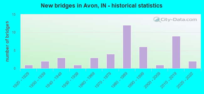
- New bridges - historical statistics
- 11920-1929
- 21930-1939
- 31940-1949
- 11950-1959
- 31960-1969
- 41970-1979
- 121980-1989
- 61990-1999
- 12000-2009
- 92010-2019
- 22020-2022
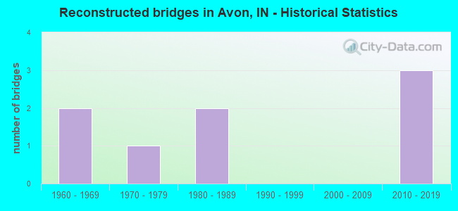
- Reconstructed bridges - Historical Statistics
- 21960-1969
- 11970-1979
- 21980-1989
- 01990-1999
- 02000-2009
- 32010-2019
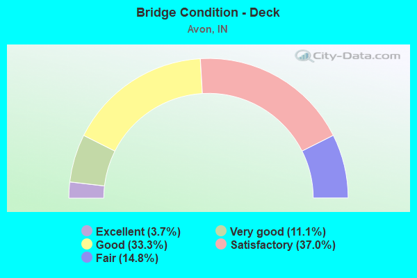
- Bridge Condition - Deck
- 3.7%Excellent
- 11.1%Very good
- 33.3%Good
- 37.0%Satisfactory
- 14.8%Fair
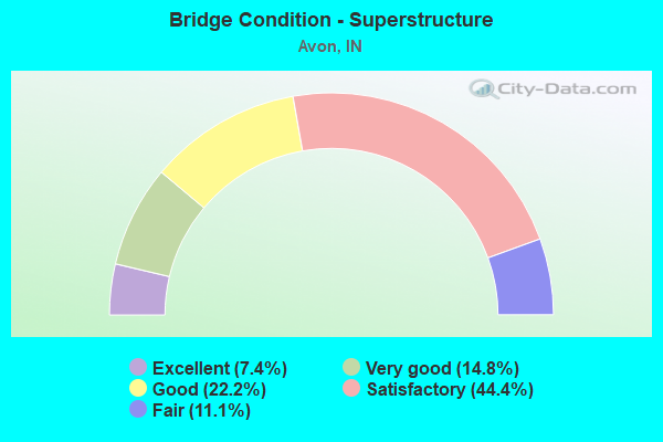
- Bridge Condition - Superstructure
- 7.4%Excellent
- 14.8%Very good
- 22.2%Good
- 44.4%Satisfactory
- 11.1%Fair
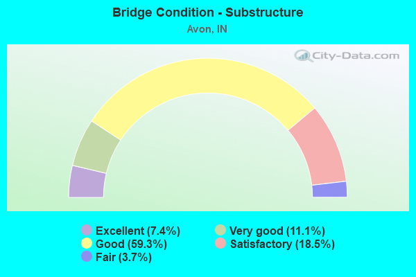
- Bridge Condition - Substructure
- 7.4%Excellent
- 11.1%Very good
- 59.3%Good
- 18.5%Satisfactory
- 3.7%Fair
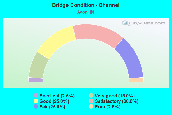
- Bridge Condition - Channel
- 2.5%Excellent
- 15.0%Very good
- 25.0%Good
- 30.0%Satisfactory
- 25.0%Fair
- 2.5%Poor
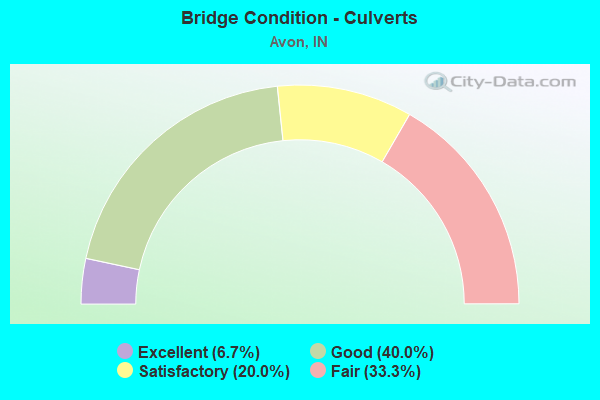
- Bridge Condition - Culverts
- 6.7%Excellent
- 40.0%Good
- 20.0%Satisfactory
- 33.3%Fair
Find on map >> Show street view
Structure Number: 3200916, Location: 00.52 N OF US 36 (Lat: 39.767050, Lng: -86.349617), Route carried "on" structure: County highway , Year Built: 2012, Status: Open, Structure Length: 1.61m (5.28ft), Average Daily Traffic: 125 (year 2020), Truck Traffic: 5%, Average Future Daily Traffic: 150 (year 2040), Design Load: HS 25 or greater, Features Intersected: AVON CREEK, Facility Carried by Structure: GABLE DRIVE
Minimum Vertical Clearance: 30+ m (98+ ft), Kilometerpoint: 0.000, Lanes on structure: 2, Owner: County Highway Agency, Approaching Roadway Width: 8.2m (26.9ft), Skew: 5 degrees, Material/Design: Concrete, Design/Construction: Culvert, Number Of Spans In Main Unit: 1, Length of Maximum Span: 15.2m (49.9ft), Curb or Sidewalk Widths: Left: 1.5m (4.9ft), Right: 0.0m, Curb-To-Curb Width: 8.2m (26.9ft), Out-to-Out Width: 24.9m (81.7ft)
Condition: Channel: Very good, Culverts: Good, Operating Rating: 40.8 metric tons, Method Used To Determine Operating Rating: Field evaluation and documented engineering judgment, Inventory Rating: 32.7 metric tons, Method Used To Determine Inventory Rating: Field evaluation and documented engineering judgment, Structural Evaluation: Better than present minimum criteria, Deck Geometry: Somewhat better than minimum adequacy, Waterway Adequacy: Equal to present desirable criteria, Approach Roadway Alignment: Equal to present desirable criteria, Designated Inspection Frequency: Every 24 months, Inspection Date: June 2020, Wearing Surface/Protective System: Wearing Surface: Bituminous
Find on map >> Show street view
Structure Number: 918, Location: 00.81 N US 50 (Lat: 38.970931, Lng: -85.834678), Route carried "under" structure: US 31, Year Built: 1936, Structure Length: 0. m, Average Daily Traffic: 7,876 (year 2004), Truck Traffic: 10%, Features Intersected: CSX RR
Minimum Vertical Clearance: 4.27m (14.01ft), Kilometerpoint: 23.850, Lanes under structure: 2, Material/Design: Steel, Design/Construction: Stringer/Multi-beam, Length of Maximum Span: 9.8m (32.2ft)
Find on map >> Show street view
Structure Number: 3200912, Location: 00.20 S US 36 (Lat: 39.759200, Lng: -86.336731), Route carried "under" structure: ServiceCounty highway , Year Built: 2012, Structure Length: 0. m, Average Daily Traffic: 200 (year 2009), Truck Traffic: 20%, Features Intersected: MAIN ROAD, Facility Carried by Structure: RONALD REAGAN PKWY
Minimum Vertical Clearance: 7.24m (23.75ft), Kilometerpoint: 0.000, Lanes on structure: 4, Lanes under structure: 2, Material/Design: Prestressed concrete continuous, Design/Construction: Stringer/Multi-beam, Length of Maximum Span: 44.7m (146.7ft)