Bridge Statistics for Avondale, Missouri (MO)
Condition, Traffic, Stress, Structural Evaluation, Project Costs
- National Bridge Inventory (NBI) Statistics
- 106Number of bridges
- 1,493ft / 455mTotal length
- $3,919,000Total costs
- 1,634,895Total average daily traffic
- 161,873Total average daily truck traffic
- National Bridge Inventory (NBI) Registered Bridges for Avondale
- No street view available for this location
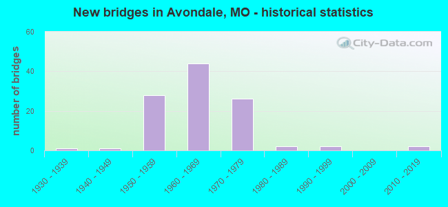
- New bridges - historical statistics
- 11930-1939
- 11940-1949
- 281950-1959
- 441960-1969
- 261970-1979
- 21980-1989
- 21990-1999
- 22010-2019

- Reconstructed bridges - Historical Statistics
- 11960-1969
- 91970-1979
- 121980-1989
- 01990-1999
- 82000-2009
- 12010-2019


- Bridge Condition - Deck
- 2.3%Very good
- 43.2%Good
- 34.1%Satisfactory
- 20.5%Fair

- Bridge Condition - Superstructure
- 4.5%Excellent
- 6.8%Very good
- 47.7%Good
- 22.7%Satisfactory
- 18.2%Fair

- Bridge Condition - Substructure
- 18.2%Very good
- 27.3%Good
- 40.9%Satisfactory
- 11.4%Fair
- 2.3%Poor

- Bridge Condition - Channel
- 29.4%Very good
- 11.8%Good
- 41.2%Satisfactory
- 11.8%Fair
- 5.9%Poor

- Bridge Condition - Culverts
- 9.1%Good
- 63.6%Satisfactory
- 27.3%Fair
Find on map >> Show street view
Structure Number: 11808, Location: S 10 T 50 N R 32 W (Lat: 39.158378, Lng: -94.487431), Route carried "on" structure: State highway 210, Year Built: 1999, Status: Open, Structure Length: 6.07m (19.91ft), Average Daily Traffic: 8,405 (year 2021), Truck Traffic: 5%, Average Future Daily Traffic: 15,129 (year 2041), Design Load: HS 25 or greater, Features Intersected: BNSF RR
Minimum Vertical Clearance: 30+ m (98+ ft), Kilometerpoint: 7.055, Lanes on structure: 2, Base Highway Network: Yes, Owner: State Highway Agency, Approaching Roadway Width: 11.6m (38.1ft), Material/Design: Steel continuous, Design/Construction: Stringer/Multi-beam, Number Of Spans In Main Unit: 3, Length of Maximum Span: 22.9m (75.1ft), Curb-To-Curb Width: 13.1m (43.0ft), Out-to-Out Width: 13.9m (45.6ft)
Condition: Deck: Very good, Superstructure: Excellent, Substructure: Very good, Operating Rating: 81.0 metric tons, Method Used To Determine Operating Rating: Load Factor (LF), Inventory Rating: 48.6 metric tons, Method Used To Determine Inventory Rating: Load Factor (LF), Structural Evaluation: Equal to present desirable criteria, Deck Geometry: Superior to present desirable criteria, Underclear: Equal to present desirable criteria, Approach Roadway Alignment: Equal to present desirable criteria, Designated Inspection Frequency: Every 24 months, Inspection Date: September 2020, Deck Structure Type: Concrete Cast-file-Place, Wearing Surface/Protective System: Wearing Surface: Monolithic Concrete, Deck Protection: Epoxy Coated Reinforcing
Find on map >> Show street view
Structure Number: 11809, Location: S 10 T 50 N R 32 W (Lat: 39.156311, Lng: -94.483692), Route carried "on" structure: State highway 210, Year Built: 1999, Status: Open, Structure Length: 10.52m (34.51ft), Average Daily Traffic: 8,405 (year 2021), Truck Traffic: 5%, Average Future Daily Traffic: 15,129 (year 2041), Design Load: HS 25 or greater, Features Intersected: BNSF RR
Minimum Vertical Clearance: 30+ m (98+ ft), Kilometerpoint: 7.430, Lanes on structure: 2, Base Highway Network: Yes, Owner: State Highway Agency, Approaching Roadway Width: 11.6m (38.1ft), Skew: 4 degrees, Material/Design: Steel continuous, Design/Construction: Stringer/Multi-beam, Number Of Spans In Main Unit: 4, Length of Maximum Span: 34.1m (111.9ft), Curb-To-Curb Width: 13.1m (43.0ft), Out-to-Out Width: 13.9m (45.6ft)
Condition: Deck: Good, Superstructure: Excellent, Substructure: Very good, Operating Rating: 57.6 metric tons, Method Used To Determine Operating Rating: Load Factor (LF), Inventory Rating: 34.2 metric tons, Method Used To Determine Inventory Rating: Load Factor (LF), Structural Evaluation: Equal to present desirable criteria, Deck Geometry: Superior to present desirable criteria, Underclear: Somewhat better than minimum adequacy, Approach Roadway Alignment: Equal to present desirable criteria, Designated Inspection Frequency: Every 24 months, Inspection Date: September 2020, Deck Structure Type: Concrete Cast-file-Place, Wearing Surface/Protective System: Wearing Surface: Monolithic Concrete, Deck Protection: Epoxy Coated Reinforcing
Find on map >> Show street view
Structure Number: 1182, Location: S 123 T 32 N R 10 W (Lat: 37.498961, Lng: -91.988550), Route carried "on" structure: State highway 32, Year Built: 1965, Status: Open, Structure Length: 13.35m (43.80ft), Average Daily Traffic: 1,021 (year 2021), Truck Traffic: 7%, Average Future Daily Traffic: 1,532 (year 2041), Design Load: H 15, Features Intersected: BIG PINEY RIVER
Minimum Vertical Clearance: 30+ m (98+ ft), Kilometerpoint: 231.488, Lanes on structure: 2, Base Highway Network: Yes, Owner: State Highway Agency, Approaching Roadway Width: 6.7m (22.0ft), Material/Design: Steel continuous, Design/Construction: Stringer/Multi-beam, Number Of Spans In Main Unit: 3, Number Of Approach Spans: 2, Length of Maximum Span: 38.1m (125.0ft), Curb-To-Curb Width: 7.9m (25.9ft), Out-to-Out Width: 8.7m (28.5ft)
Condition: Deck: Fair, Superstructure: Satisfactory, Substructure: Good, Channel: Satisfactory, Operating Rating: 34.2 metric tons, Method Used To Determine Operating Rating: Load Factor (LF), Inventory Rating: 20.7 metric tons, Method Used To Determine Inventory Rating: Load Factor (LF), Structural Evaluation: Somewhat better than minimum adequacy, Deck Geometry: Meets minimum limits, Waterway Adequacy: Equal to present desirable criteria, Approach Roadway Alignment: Equal to present desirable criteria, Designated Inspection Frequency: Every 24 months, Other Special Inspection Frequency: Every 24 months, Inspection Date: April 2020, Other Special Inspection Date: April 2020, Deck Structure Type: Concrete Cast-file-Place, Wearing Surface/Protective System: Wearing Surface: Bituminous
Find on map >> Show street view
Structure Number: 12841, Location: S 7 T 50 N R 33 W (Lat: 39.153450, Lng: -94.548200), Route carried "on" structure: City street , Year Built: 1975, Status: Posted for load, Structure Length: 0.98m (3.22ft), Average Daily Traffic: 500 (year 2020), Truck Traffic: 10%, Average Future Daily Traffic: 800 (year 2040), Features Intersected: ROCK CR, Facility Carried by Structure: WALKER RD
Minimum Vertical Clearance: 30+ m (98+ ft), Kilometerpoint: 0.161, Lanes on structure: 2, Owner: City or Municipal Highway Agency, Approaching Roadway Width: 7.0m (23.0ft), Material/Design: Steel, Design/Construction: Stringer/Multi-beam, Number Of Spans In Main Unit: 1, Length of Maximum Span: 9.4m (30.8ft), Curb-To-Curb Width: 7.3m (24.0ft), Out-to-Out Width: 7.9m (25.9ft)
Condition: Deck: Satisfactory, Superstructure: Good, Substructure: Fair, Channel: Fair, Operating Rating: 32.4 metric tons, Method Used To Determine Operating Rating: Allowable Stress (AS), Inventory Rating: 18.9 metric tons, Method Used To Determine Inventory Rating: Allowable Stress (AS), Structural Evaluation: Somewhat better than minimum adequacy, Deck Geometry: Meets minimum limits, Waterway Adequacy: Better than present minimum criteria, Approach Roadway Alignment: Equal to present desirable criteria, Designated Inspection Frequency: Every 24 months, Inspection Date: December 2021, Deck Structure Type: Concrete Cast-file-Place, Wearing Surface/Protective System: Wearing Surface: Bituminous
Find on map >> Show street view
Structure Number: 1292, Location: S 34 T 51 N R 33 W (Lat: 39.181792, Lng: -94.594078), Route carried "on" structure: Ramp State highway , Year Built: 1965, Year Reconstructed: 1989, Status: Open, Structure Length: 7.80m (25.59ft), Average Daily Traffic: 12,648 (year 2021), Truck Traffic: 2%, Average Future Daily Traffic: 22,766 (year 2041), Design Load: HS 20, Features Intersected: US 69, Facility Carried by Structure: RP IS29S TO US169S
Minimum Vertical Clearance: 30+ m (98+ ft), Kilometerpoint: 0.389, Lanes on structure: 1, Lanes under structure: 4, Base Highway Network: Yes, Owner: State Highway Agency, Approaching Roadway Width: 8.5m (27.9ft), Material/Design: Concrete continuous, Design/Construction: Box Beam or Girders - Single/Spread, Number Of Spans In Main Unit: 3, Length of Maximum Span: 29.9m (98.1ft), Curb-To-Curb Width: 7.3m (24.0ft), Out-to-Out Width: 8.1m (26.6ft)
Condition: Deck: Satisfactory, Superstructure: Satisfactory, Substructure: Satisfactory, Operating Rating: 71.1 metric tons, Method Used To Determine Operating Rating: Load Factor (LF), Inventory Rating: 42.3 metric tons, Method Used To Determine Inventory Rating: Load Factor (LF), Structural Evaluation: Equal to present minimum criteria, Deck Geometry: Better than present minimum criteria, Underclear: High priority of corrective action, Approach Roadway Alignment: Equal to present desirable criteria, Designated Inspection Frequency: Every 24 months, Inspection Date: September 2020, Deck Structure Type: Concrete Cast-file-Place, Wearing Surface/Protective System: Wearing Surface: Other, Deck Protection: Cathodic Protection
Find on map >> Show street view
Structure Number: 1293, Location: S 34 T 51 N R 33 W (Lat: 39.181711, Lng: -94.593764), Route carried "on" structure: US 169, Year Built: 1965, Year Reconstructed: 1989, Status: Open, Structure Length: 7.38m (24.21ft), Average Daily Traffic: 16,379 (year 2021), Truck Traffic: 3%, Average Future Daily Traffic: 29,482 (year 2041), Design Load: HS 20, Features Intersected: US 69
Minimum Vertical Clearance: 30+ m (98+ ft), Kilometerpoint: 193.833, Lanes on structure: 2, Lanes under structure: 4, Base Highway Network: Yes, Owner: State Highway Agency, Approaching Roadway Width: 11.6m (38.1ft), Material/Design: Concrete continuous, Design/Construction: Box Beam or Girders - Single/Spread, Number Of Spans In Main Unit: 3, Length of Maximum Span: 28.0m (91.9ft), Curb-To-Curb Width: 9.8m (32.2ft), Out-to-Out Width: 10.5m (34.4ft)
Condition: Deck: Good, Superstructure: Good, Substructure: Very good, Operating Rating: 81.9 metric tons, Method Used To Determine Operating Rating: Load Factor (LF), Inventory Rating: 49.5 metric tons, Method Used To Determine Inventory Rating: Load Factor (LF), Structural Evaluation: Better than present minimum criteria, Deck Geometry: Meets minimum limits, Underclear: High priority of corrective action, Approach Roadway Alignment: Equal to present desirable criteria, Designated Inspection Frequency: Every 24 months, Inspection Date: September 2020, Deck Structure Type: Concrete Cast-file-Place, Wearing Surface/Protective System: Wearing Surface: Low Slump Concrete
Find on map >> Show street view
Structure Number: 1294, Location: S 34 T 51 N R 33 W (Lat: 39.181136, Lng: -94.593206), Route carried "on" structure: Ramp State highway , Year Built: 1965, Year Reconstructed: 1989, Status: Open, Structure Length: 7.74m (25.39ft), Average Daily Traffic: 12,414 (year 2021), Truck Traffic: 3%, Average Future Daily Traffic: 22,345 (year 2041), Design Load: HS 20, Features Intersected: US 69, Facility Carried by Structure: RP US169N TO IS29N
Minimum Vertical Clearance: 30+ m (98+ ft), Kilometerpoint: 0.140, Lanes on structure: 1, Lanes under structure: 4, Base Highway Network: Yes, Owner: State Highway Agency, Approaching Roadway Width: 8.5m (27.9ft), Material/Design: Concrete continuous, Design/Construction: Box Beam or Girders - Single/Spread, Number Of Spans In Main Unit: 3, Length of Maximum Span: 29.3m (96.1ft), Curb-To-Curb Width: 7.3m (24.0ft), Out-to-Out Width: 8.1m (26.6ft)
Condition: Deck: Satisfactory, Superstructure: Good, Substructure: Very good, Operating Rating: 62.1 metric tons, Method Used To Determine Operating Rating: Load Factor (LF), Inventory Rating: 36.9 metric tons, Method Used To Determine Inventory Rating: Load Factor (LF), Structural Evaluation: Better than present minimum criteria, Deck Geometry: Better than present minimum criteria, Underclear: High priority of corrective action, Approach Roadway Alignment: Equal to present desirable criteria, Designated Inspection Frequency: Every 24 months, Inspection Date: September 2020, Deck Structure Type: Concrete Cast-file-Place, Wearing Surface/Protective System: Wearing Surface: Other, Membrane: Built-up, Deck Protection: Epoxy Coated Reinforcing
Find on map >> Show street view
Structure Number: 1295, Location: S 334 T 51 N R 33 W (Lat: 39.180950, Lng: -94.592978), Route carried "on" structure: US 169, Year Built: 1965, Year Reconstructed: 1989, Status: Open, Structure Length: 6.40m (21.00ft), Average Daily Traffic: 14,448 (year 2021), Truck Traffic: 5%, Average Future Daily Traffic: 26,006 (year 2041), Design Load: HS 20, Features Intersected: US 69
Minimum Vertical Clearance: 30+ m (98+ ft), Kilometerpoint: 10.240, Lanes on structure: 2, Lanes under structure: 3, Base Highway Network: Yes, Owner: State Highway Agency, Approaching Roadway Width: 11.6m (38.1ft), Material/Design: Concrete continuous, Design/Construction: Box Beam or Girders - Single/Spread, Number Of Spans In Main Unit: 3, Length of Maximum Span: 24.4m (80.1ft), Curb-To-Curb Width: 9.8m (32.2ft), Out-to-Out Width: 10.5m (34.4ft)
Condition: Deck: Good, Superstructure: Good, Substructure: Very good, Operating Rating: 89.1 metric tons, Method Used To Determine Operating Rating: Load Factor (LF), Inventory Rating: 54.0 metric tons, Method Used To Determine Inventory Rating: Load Factor (LF), Structural Evaluation: Better than present minimum criteria, Deck Geometry: Meets minimum limits, Underclear: High priority of corrective action, Approach Roadway Alignment: Equal to present desirable criteria, Designated Inspection Frequency: Every 24 months, Inspection Date: September 2020, Deck Structure Type: Concrete Cast-file-Place, Wearing Surface/Protective System: Wearing Surface: Low Slump Concrete, Deck Protection: Cathodic Protection
Find on map >> Show street view
Structure Number: 1297, Location: S 10 T 50 N R 33 W (Lat: 39.161408, Lng: -94.590092), Route carried "on" structure: Ramp State highway , Year Built: 1965, Year Reconstructed: 1975, Status: Posted for load, Structure Length: 5.76m (18.90ft), Average Daily Traffic: 7,606 (year 2021), Truck Traffic: 5%, Average Future Daily Traffic: 13,691 (year 2041), Design Load: HS 20, Features Intersected: MO 9, Facility Carried by Structure: RP US169S TO MO9N
Minimum Vertical Clearance: 30+ m (98+ ft), Kilometerpoint: 0.111, Lanes on structure: 1, Lanes under structure: 3, Base Highway Network: Yes, Owner: State Highway Agency, Approaching Roadway Width: 7.9m (25.9ft), Skew: 3 degrees, Material/Design: Steel continuous, Design/Construction: Stringer/Multi-beam, Number Of Spans In Main Unit: 3, Length of Maximum Span: 22.0m (72.2ft), Curb-To-Curb Width: 7.9m (25.9ft), Out-to-Out Width: 8.7m (28.5ft)
Condition: Deck: Satisfactory, Superstructure: Very good, Substructure: Satisfactory, Operating Rating: 39.6 metric tons, Method Used To Determine Operating Rating: Load Factor (LF), Inventory Rating: 23.4 metric tons, Method Used To Determine Inventory Rating: Load Factor (LF), Structural Evaluation: Somewhat better than minimum adequacy, Deck Geometry: Equal to present desirable criteria, Underclear: High priority of corrective action, Approach Roadway Alignment: Equal to present desirable criteria, Designated Inspection Frequency: Every 24 months, Inspection Date: September 2020, Deck Structure Type: Concrete Cast-file-Place, Wearing Surface/Protective System: Wearing Surface: Monolithic Concrete, Deck Protection: Epoxy Coated Reinforcing
Find on map >> Show street view
Structure Number: 1298, Location: S 10 T 50 N R 33 W (Lat: 39.161306, Lng: -94.589611), Route carried "on" structure: US 169, Year Built: 1975, Year Reconstructed: 2007, Status: Open, Structure Length: 6.68m (21.92ft), Average Daily Traffic: 16,124 (year 2021), Truck Traffic: 5%, Average Future Daily Traffic: 29,023 (year 2041), Design Load: HS 20, Features Intersected: MO 9
Minimum Vertical Clearance: 30+ m (98+ ft), Kilometerpoint: 7.875, Lanes on structure: 2, Lanes under structure: 3, Base Highway Network: Yes, Owner: State Highway Agency, Approaching Roadway Width: 11.6m (38.1ft), Skew: 14 degrees, Material/Design: Steel continuous, Design/Construction: Stringer/Multi-beam, Number Of Spans In Main Unit: 3, Length of Maximum Span: 26.8m (87.9ft), Curb or Sidewalk Widths: Left: 0.2m (0.7ft), Right: 0.2m (0.7ft), Curb-To-Curb Width: 9.8m (32.2ft), Out-to-Out Width: 10.6m (34.8ft)
Condition: Deck: Satisfactory, Superstructure: Good, Substructure: Good, Operating Rating: 55.8 metric tons, Method Used To Determine Operating Rating: Load Factor (LF), Inventory Rating: 33.3 metric tons, Method Used To Determine Inventory Rating: Load Factor (LF), Structural Evaluation: Better than present minimum criteria, Deck Geometry: Meets minimum limits, Underclear: High priority of corrective action, Approach Roadway Alignment: Equal to present minimum criteria, Designated Inspection Frequency: Every 24 months, Inspection Date: September 2020, Deck Structure Type: Concrete Cast-file-Place, Wearing Surface/Protective System: Wearing Surface: Low Slump Concrete
Find on map >> Show street view
Structure Number: 1299, Location: S 10 T 50 N R 33 W (Lat: 39.161375, Lng: -94.589758), Route carried "on" structure: US 169, Year Built: 1965, Year Reconstructed: 2007, Status: Open, Structure Length: 6.68m (21.92ft), Average Daily Traffic: 14,932 (year 2021), Truck Traffic: 3%, Average Future Daily Traffic: 26,878 (year 2041), Design Load: HS 20, Features Intersected: MO 9
Minimum Vertical Clearance: 30+ m (98+ ft), Kilometerpoint: 196.220, Lanes on structure: 2, Lanes under structure: 3, Base Highway Network: Yes, Owner: State Highway Agency, Approaching Roadway Width: 11.6m (38.1ft), Skew: 14 degrees, Material/Design: Steel continuous, Design/Construction: Stringer/Multi-beam, Number Of Spans In Main Unit: 3, Length of Maximum Span: 26.8m (87.9ft), Curb-To-Curb Width: 11.6m (38.1ft), Out-to-Out Width: 12.4m (40.7ft)
Condition: Deck: Good, Superstructure: Good, Substructure: Satisfactory, Operating Rating: 59.4 metric tons, Method Used To Determine Operating Rating: Load Factor (LF), Inventory Rating: 35.1 metric tons, Method Used To Determine Inventory Rating: Load Factor (LF), Structural Evaluation: Equal to present minimum criteria, Deck Geometry: Equal to present minimum criteria, Underclear: High priority of corrective action, Approach Roadway Alignment: Equal to present desirable criteria, Designated Inspection Frequency: Every 24 months, Inspection Date: September 2020, Deck Structure Type: Concrete Cast-file-Place, Wearing Surface/Protective System: Wearing Surface: Low Slump Concrete
Find on map >> Show street view
Structure Number: 13, Location: S 10 T 50 N R 33 W (Lat: 39.158725, Lng: -94.589144), Route carried "on" structure: US 169, Year Built: 1975, Year Reconstructed: 2007, Status: Posted for load, Structure Length: 6.13m (20.11ft), Average Daily Traffic: 16,668 (year 2021), Truck Traffic: 3%, Average Future Daily Traffic: 30,002 (year 2041), Design Load: HS 20, Features Intersected: MO 9
Minimum Vertical Clearance: 30+ m (98+ ft), Kilometerpoint: 196.537, Lanes on structure: 2, Lanes under structure: 2, Base Highway Network: Yes, Owner: State Highway Agency, Approaching Roadway Width: 11.6m (38.1ft), Skew: 24 degrees, Material/Design: Steel continuous, Design/Construction: Stringer/Multi-beam, Number Of Spans In Main Unit: 3, Length of Maximum Span: 23.8m (78.1ft), Curb-To-Curb Width: 11.6m (38.1ft), Out-to-Out Width: 12.4m (40.7ft)
Condition: Deck: Good, Superstructure: Good, Substructure: Satisfactory, Operating Rating: 54.0 metric tons, Method Used To Determine Operating Rating: Load Factor (LF), Inventory Rating: 32.4 metric tons, Method Used To Determine Inventory Rating: Load Factor (LF), Structural Evaluation: Equal to present minimum criteria, Deck Geometry: Equal to present minimum criteria, Underclear: High priority of corrective action, Approach Roadway Alignment: Equal to present desirable criteria, Designated Inspection Frequency: Every 24 months, Inspection Date: September 2020, Deck Structure Type: Concrete Cast-file-Place, Wearing Surface/Protective System: Wearing Surface: Low Slump Concrete, Membrane: Built-up
Find on map >> Show street view
Structure Number: 1301, Location: S 10 T 50 N R 33 W (Lat: 39.158658, Lng: -94.588969), Route carried "on" structure: US 169, Year Built: 1965, Year Reconstructed: 2007, Status: Posted for load, Structure Length: 6.13m (20.11ft), Average Daily Traffic: 16,124 (year 2021), Truck Traffic: 5%, Average Future Daily Traffic: 29,023 (year 2041), Design Load: HS 20, Features Intersected: MO 9
Minimum Vertical Clearance: 30+ m (98+ ft), Kilometerpoint: 7.604, Lanes on structure: 2, Lanes under structure: 2, Base Highway Network: Yes, Owner: State Highway Agency, Approaching Roadway Width: 11.6m (38.1ft), Skew: 24 degrees, Material/Design: Steel continuous, Design/Construction: Stringer/Multi-beam, Number Of Spans In Main Unit: 3, Length of Maximum Span: 23.8m (78.1ft), Curb or Sidewalk Widths: Left: 0.2m (0.7ft), Right: 0.2m (0.7ft), Curb-To-Curb Width: 9.8m (32.2ft), Out-to-Out Width: 10.6m (34.8ft)
Condition: Deck: Satisfactory, Superstructure: Good, Substructure: Satisfactory, Operating Rating: 48.6 metric tons, Method Used To Determine Operating Rating: Load Factor (LF), Inventory Rating: 28.8 metric tons, Method Used To Determine Inventory Rating: Load Factor (LF), Structural Evaluation: Equal to present minimum criteria, Deck Geometry: Meets minimum limits, Underclear: High priority of corrective action, Approach Roadway Alignment: Better than present minimum criteria, Designated Inspection Frequency: Every 24 months, Inspection Date: September 2020, Deck Structure Type: Concrete Cast-file-Place, Wearing Surface/Protective System: Wearing Surface: Monolithic Concrete, Deck Protection: Epoxy Coated Reinforcing
Find on map >> Show street view
Structure Number: 1302, Location: S 10 T 50 N R 33 W (Lat: 39.158417, Lng: -94.588742), Route carried "on" structure: Ramp State highway , Year Built: 1965, Year Reconstructed: 2007, Status: Posted for load, Structure Length: 5.09m (16.70ft), Average Daily Traffic: 5,011 (year 2021), Truck Traffic: 3%, Average Future Daily Traffic: 9,020 (year 2041), Design Load: H 20, Features Intersected: MO 9, Facility Carried by Structure: RP US169N TO MO9N
Minimum Vertical Clearance: 30+ m (98+ ft), Kilometerpoint: 0.064, Lanes on structure: 1, Lanes under structure: 2, Base Highway Network: Yes, Owner: State Highway Agency, Approaching Roadway Width: 8.5m (27.9ft), Skew: 3 degrees, Material/Design: Steel continuous, Design/Construction: Stringer/Multi-beam, Number Of Spans In Main Unit: 3, Length of Maximum Span: 21.0m (68.9ft), Curb-To-Curb Width: 7.3m (24.0ft), Out-to-Out Width: 8.1m (26.6ft)
Condition: Deck: Good, Superstructure: Good, Substructure: Good, Operating Rating: 39.6 metric tons, Method Used To Determine Operating Rating: Load Factor (LF), Inventory Rating: 23.4 metric tons, Method Used To Determine Inventory Rating: Load Factor (LF), Structural Evaluation: Somewhat better than minimum adequacy, Deck Geometry: Better than present minimum criteria, Underclear: High priority of corrective action, Approach Roadway Alignment: Equal to present desirable criteria, Length Of Structure Improvement: 0.61m (2.00ft), Designated Inspection Frequency: Every 24 months, Inspection Date: September 2020, Bridge Improvement Cost: $498,000, Roadway Improvement Cost: $50,000, Total Project Cost: $747,000 ( Estimate for 2022), Deck Structure Type: Concrete Cast-file-Place, Wearing Surface/Protective System: Wearing Surface: Low Slump Concrete
Find on map >> Show street view
Structure Number: 1307, Location: S 34 T 51 N R 33 W (Lat: 39.183375, Lng: -94.593061), Route carried "on" structure: US 169, Year Built: 1965, Year Reconstructed: 1989, Status: Open, Structure Length: 4.85m (15.91ft), Average Daily Traffic: 34,964 (year 2021), Truck Traffic: 4%, Average Future Daily Traffic: 62,935 (year 2041), Design Load: HS 20, Features Intersected: IS 29
Minimum Vertical Clearance: 5.08m (16.67ft), Kilometerpoint: 193.653, Lanes on structure: 2, Lanes under structure: 2, Base Highway Network: Yes, Owner: State Highway Agency, Approaching Roadway Width: 11.6m (38.1ft), Skew: 1 degrees, Material/Design: Concrete continuous, Design/Construction: Slab, Number Of Spans In Main Unit: 3, Length of Maximum Span: 18.9m (62.0ft), Curb-To-Curb Width: 9.8m (32.2ft), Out-to-Out Width: 10.5m (34.4ft)
Condition: Deck: Satisfactory, Superstructure: Satisfactory, Substructure: Good, Operating Rating: 94.5 metric tons, Method Used To Determine Operating Rating: Load Factor (LF), Inventory Rating: 56.7 metric tons, Method Used To Determine Inventory Rating: Load Factor (LF), Structural Evaluation: Equal to present minimum criteria, Deck Geometry: High priority of replacement, Underclear: Equal to present minimum criteria, Approach Roadway Alignment: Equal to present desirable criteria, Designated Inspection Frequency: Every 24 months, Inspection Date: September 2020, Deck Structure Type: Concrete Cast-file-Place, Wearing Surface/Protective System: Wearing Surface: Low Slump Concrete, Deck Protection: Cathodic Protection
Find on map >> Show street view
Structure Number: 1308, Location: S 34 T 51 N R 33 W (Lat: 39.183453, Lng: -94.593044), Route carried "on" structure: Ramp State highway , Year Built: 1965, Year Reconstructed: 1989, Status: Open, Structure Length: 11.83m (38.81ft), Average Daily Traffic: 12,414 (year 2021), Truck Traffic: 3%, Average Future Daily Traffic: 22,345 (year 2041), Design Load: HS 20, Features Intersected: US 169, Facility Carried by Structure: RP US169N TO IS29N
Minimum Vertical Clearance: 30+ m (98+ ft), Kilometerpoint: 0.364, Lanes on structure: 1, Lanes under structure: 4, Base Highway Network: Yes, Owner: State Highway Agency, Approaching Roadway Width: 5.5m (18.0ft), Material/Design: Concrete continuous, Design/Construction: Box Beam or Girders - Single/Spread, Number Of Spans In Main Unit: 5, Length of Maximum Span: 27.4m (89.9ft), Curb-To-Curb Width: 7.3m (24.0ft), Out-to-Out Width: 8.1m (26.6ft)
Condition: Deck: Satisfactory, Superstructure: Satisfactory, Substructure: Satisfactory, Operating Rating: 68.4 metric tons, Method Used To Determine Operating Rating: Load Factor (LF), Inventory Rating: 41.4 metric tons, Method Used To Determine Inventory Rating: Load Factor (LF), Structural Evaluation: Equal to present minimum criteria, Deck Geometry: Better than present minimum criteria, Underclear: Meets minimum limits, Approach Roadway Alignment: Equal to present desirable criteria, Designated Inspection Frequency: Every 24 months, Inspection Date: September 2020, Deck Structure Type: Concrete Cast-file-Place, Wearing Surface/Protective System: Wearing Surface: Other, Deck Protection: Epoxy Coated Reinforcing
Find on map >> Show street view
Structure Number: 1309, Location: S 34 T 51 N R 33 W (Lat: 39.182814, Lng: -94.591586), Route carried "on" structure: US 169, Year Built: 1965, Year Reconstructed: 1989, Status: Open, Structure Length: 8.99m (29.49ft), Average Daily Traffic: 16,988 (year 2021), Truck Traffic: 5%, Average Future Daily Traffic: 30,578 (year 2041), Design Load: HS 20, Features Intersected: IS 29, RP US169S TO IS29
Minimum Vertical Clearance: 30+ m (98+ ft), Kilometerpoint: 10.470, Lanes on structure: 3, Lanes under structure: 3, Base Highway Network: Yes, Owner: State Highway Agency, Approaching Roadway Width: 14.6m (47.9ft), Skew: 3 degrees, Material/Design: Concrete continuous, Design/Construction: Slab, Number Of Spans In Main Unit: 5, Length of Maximum Span: 20.7m (67.9ft), Curb-To-Curb Width: 12.5m (41.0ft), Out-to-Out Width: 13.3m (43.6ft)
Condition: Deck: Satisfactory, Superstructure: Satisfactory, Substructure: Satisfactory, Operating Rating: 65.7 metric tons, Method Used To Determine Operating Rating: Load Factor (LF), Inventory Rating: 39.6 metric tons, Method Used To Determine Inventory Rating: Load Factor (LF), Structural Evaluation: Equal to present minimum criteria, Deck Geometry: Meets minimum limits, Underclear: Somewhat better than minimum adequacy, Approach Roadway Alignment: Equal to present desirable criteria, Designated Inspection Frequency: Every 24 months, Inspection Date: September 2020, Deck Structure Type: Concrete Cast-file-Place, Wearing Surface/Protective System: Wearing Surface: Low Slump Concrete, Deck Protection: Cathodic Protection
Find on map >> Show street view
Structure Number: 131, Location: S 4 T 48 N R 15 W (Lat: 38.944667, Lng: -92.568750), Route carried "on" structure: Interstate 70, Year Built: 1958, Year Reconstructed: 1988, Status: Open, Structure Length: 4.69m (15.39ft), Average Daily Traffic: 19,158 (year 2021), Truck Traffic: 24%, Average Future Daily Traffic: 34,484 (year 2041), Design Load: HS 20, Features Intersected: UP RR
Minimum Vertical Clearance: 30+ m (98+ ft), Kilometerpoint: 220.342, Lanes on structure: 2, Base Highway Network: Yes, Owner: State Highway Agency, Approaching Roadway Width: 12.8m (42.0ft), Skew: 20 degrees, Material/Design: Steel continuous, Design/Construction: Stringer/Multi-beam, Number Of Spans In Main Unit: 3, Length of Maximum Span: 17.1m (56.1ft), Curb or Sidewalk Widths: Left: 0.2m (0.7ft), Right: 0.2m (0.7ft), Curb-To-Curb Width: 11.5m (37.7ft), Out-to-Out Width: 12.3m (40.4ft)
Condition: Deck: Good, Superstructure: Good, Substructure: Good, Operating Rating: 81.9 metric tons, Method Used To Determine Operating Rating: Load Factor (LF), Inventory Rating: 49.5 metric tons, Method Used To Determine Inventory Rating: Load Factor (LF), Structural Evaluation: Better than present minimum criteria, Deck Geometry: Somewhat better than minimum adequacy, Underclear: Superior to present desirable criteria, Approach Roadway Alignment: Equal to present desirable criteria, Designated Inspection Frequency: Every 24 months, Inspection Date: July 2021, Deck Structure Type: Concrete Cast-file-Place, Wearing Surface/Protective System: Wearing Surface: Monolithic Concrete, Deck Protection: Epoxy Coated Reinforcing
Find on map >> Show street view
Structure Number: 131, Location: S 3 T 50 N R 33 W (Lat: 39.169350, Lng: -94.594911), Route carried "on" structure: US 169, Year Built: 1965, Year Reconstructed: 1975, Status: Open, Structure Length: 7.56m (24.80ft), Average Daily Traffic: 14,932 (year 2021), Truck Traffic: 3%, Average Future Daily Traffic: 26,878 (year 2041), Design Load: HS 20, Features Intersected: CST NW BRIARCLIFF PKWY
Minimum Vertical Clearance: 30+ m (98+ ft), Kilometerpoint: 195.215, Lanes on structure: 2, Lanes under structure: 5, Base Highway Network: Yes, Owner: State Highway Agency, Approaching Roadway Width: 11.6m (38.1ft), Skew: 3 degrees, Material/Design: Concrete continuous, Design/Construction: Box Beam or Girders - Single/Spread, Number Of Spans In Main Unit: 3, Length of Maximum Span: 30.8m (101.0ft), Curb-To-Curb Width: 9.8m (32.2ft), Out-to-Out Width: 10.5m (34.4ft)
Condition: Deck: Good, Superstructure: Satisfactory, Substructure: Satisfactory, Operating Rating: 87.3 metric tons, Method Used To Determine Operating Rating: Load Factor (LF), Inventory Rating: 52.2 metric tons, Method Used To Determine Inventory Rating: Load Factor (LF), Structural Evaluation: Equal to present minimum criteria, Deck Geometry: Meets minimum limits, Approach Roadway Alignment: Equal to present desirable criteria, Designated Inspection Frequency: Every 24 months, Inspection Date: September 2020, Deck Structure Type: Concrete Cast-file-Place, Wearing Surface/Protective System: Wearing Surface: Low Slump Concrete
Find on map >> Show street view
Structure Number: 1311, Location: S 3 T 50 N R 33 W (Lat: 39.169417, Lng: -94.594681), Route carried "on" structure: US 169, Year Built: 1965, Year Reconstructed: 1975, Status: Open, Structure Length: 7.56m (24.80ft), Average Daily Traffic: 14,448 (year 2021), Truck Traffic: 5%, Average Future Daily Traffic: 26,006 (year 2041), Design Load: HS 20, Features Intersected: CST NW BRIARCLIFF PKWY
Minimum Vertical Clearance: 30+ m (98+ ft), Kilometerpoint: 8.929, Lanes on structure: 2, Lanes under structure: 5, Base Highway Network: Yes, Owner: State Highway Agency, Approaching Roadway Width: 11.6m (38.1ft), Skew: 3 degrees, Material/Design: Concrete continuous, Design/Construction: Box Beam or Girders - Single/Spread, Number Of Spans In Main Unit: 3, Length of Maximum Span: 30.8m (101.0ft), Curb-To-Curb Width: 9.8m (32.2ft), Out-to-Out Width: 10.5m (34.4ft)
Condition: Deck: Satisfactory, Superstructure: Satisfactory, Substructure: Satisfactory, Operating Rating: 87.3 metric tons, Method Used To Determine Operating Rating: Load Factor (LF), Inventory Rating: 52.2 metric tons, Method Used To Determine Inventory Rating: Load Factor (LF), Structural Evaluation: Equal to present minimum criteria, Deck Geometry: Meets minimum limits, Approach Roadway Alignment: Equal to present desirable criteria, Designated Inspection Frequency: Every 24 months, Inspection Date: September 2020, Deck Structure Type: Concrete Cast-file-Place, Wearing Surface/Protective System: Wearing Surface: Low Slump Concrete
Find on map >> Show street view
Structure Number: 1456, Location: S 1 T 50 N R 33 W (Lat: 39.172272, Lng: -94.557647), Route carried "on" structure: Ramp State highway , Year Built: 1967, Status: Open, Structure Length: 0.99m (3.25ft), Average Daily Traffic: 18,556 (year 2021), Truck Traffic: 9%, Average Future Daily Traffic: 33,401 (year 2041), Design Load: HS 20, Features Intersected: ROCK CR, Facility Carried by Structure: RP IS35S TO IS29N
Minimum Vertical Clearance: 30+ m (98+ ft), Kilometerpoint: 0.311, Lanes on structure: 1, Base Highway Network: Yes, Owner: State Highway Agency, Approaching Roadway Width: 7.3m (24.0ft), Skew: 4 degrees, Material/Design: Concrete continuous, Design/Construction: Culvert, Number Of Spans In Main Unit: 2, Length of Maximum Span: 3.4m (11.2ft)
Condition: Channel: Fair, Culverts: Satisfactory, Structural Evaluation: Equal to present minimum criteria, Waterway Adequacy: Equal to present desirable criteria, Approach Roadway Alignment: Equal to present desirable criteria, Designated Inspection Frequency: Every 24 months, Inspection Date: November 2020
Find on map >> Show street view
Structure Number: 1457, Location: S 1 T 50 N R 33 W (Lat: 39.172600, Lng: -94.558319), Route carried "on" structure: Ramp State highway , Year Built: 1967, Year Reconstructed: 1989, Status: Open, Structure Length: 7.80m (25.59ft), Average Daily Traffic: 18,556 (year 2021), Truck Traffic: 9%, Average Future Daily Traffic: 33,401 (year 2041), Design Load: HS 20, Features Intersected: RP IS29N TO DAVIDSON RD, Facility Carried by Structure: RP IS35S TO IS29N
Minimum Vertical Clearance: 30+ m (98+ ft), Kilometerpoint: 0.332, Lanes on structure: 1, Lanes under structure: 1, Base Highway Network: Yes, Owner: State Highway Agency, Approaching Roadway Width: 7.3m (24.0ft), Material/Design: Concrete continuous, Design/Construction: Box Beam or Girders - Single/Spread, Number Of Spans In Main Unit: 4, Length of Maximum Span: 25.7m (84.3ft), Curb-To-Curb Width: 7.3m (24.0ft), Out-to-Out Width: 8.1m (26.6ft)
Condition: Deck: Satisfactory, Superstructure: Satisfactory, Substructure: Good, Operating Rating: 60.3 metric tons, Method Used To Determine Operating Rating: Load Factor (LF), Inventory Rating: 36.0 metric tons, Method Used To Determine Inventory Rating: Load Factor (LF), Structural Evaluation: Equal to present minimum criteria, Deck Geometry: Better than present minimum criteria, Underclear: Meets minimum limits, Approach Roadway Alignment: Equal to present desirable criteria, Designated Inspection Frequency: Every 24 months, Inspection Date: September 2020, Deck Structure Type: Concrete Cast-file-Place, Wearing Surface/Protective System: Wearing Surface: Other, Deck Protection: Epoxy Coated Reinforcing
Find on map >> Show street view
Structure Number: 1703, Location: S 10 T 50 N R 33 W (Lat: 39.165489, Lng: -94.598750), Route carried "on" structure: State highway 9, Year Built: 1969, Status: Posted for load, Structure Length: 4.63m (15.19ft), Average Daily Traffic: 7,084 (year 2021), Truck Traffic: 3%, Average Future Daily Traffic: 12,751 (year 2041), Design Load: HS 20, Features Intersected: CST NW BRIARCLIFF PKWY
Minimum Vertical Clearance: 30+ m (98+ ft), Kilometerpoint: 7.450, Lanes on structure: 2, Lanes under structure: 4, Base Highway Network: Yes, Owner: State Highway Agency, Approaching Roadway Width: 11.6m (38.1ft), Skew: 10 degrees, Material/Design: Steel continuous, Design/Construction: Stringer/Multi-beam, Number Of Spans In Main Unit: 3, Length of Maximum Span: 24.4m (80.1ft), Curb-To-Curb Width: 11.6m (38.1ft), Out-to-Out Width: 12.4m (40.7ft)
Condition: Deck: Fair, Superstructure: Good, Substructure: Fair, Operating Rating: 52.2 metric tons, Method Used To Determine Operating Rating: Load Factor (LF), Inventory Rating: 31.5 metric tons, Method Used To Determine Inventory Rating: Load Factor (LF), Structural Evaluation: Somewhat better than minimum adequacy, Deck Geometry: Equal to present minimum criteria, Underclear: High priority of corrective action, Approach Roadway Alignment: Equal to present desirable criteria, Designated Inspection Frequency: Every 24 months, Inspection Date: September 2020, Deck Structure Type: Concrete Cast-file-Place, Wearing Surface/Protective System: Wearing Surface: Monolithic Concrete
Find on map >> Show street view
Structure Number: 1704, Location: S 10 T 50 N R 33 W (Lat: 39.165308, Lng: -94.598897), Route carried "on" structure: State highway 9, Year Built: 1969, Status: Posted for load, Structure Length: 4.63m (15.19ft), Average Daily Traffic: 6,697 (year 2021), Truck Traffic: 6%, Average Future Daily Traffic: 12,055 (year 2041), Design Load: HS 20, Features Intersected: CST NW BRIARCLIFF PKWY
Minimum Vertical Clearance: 30+ m (98+ ft), Kilometerpoint: 15.390, Lanes on structure: 2, Lanes under structure: 4, Base Highway Network: Yes, Owner: State Highway Agency, Approaching Roadway Width: 11.6m (38.1ft), Skew: 10 degrees, Material/Design: Steel continuous, Design/Construction: Stringer/Multi-beam, Number Of Spans In Main Unit: 3, Length of Maximum Span: 24.4m (80.1ft), Curb-To-Curb Width: 11.6m (38.1ft), Out-to-Out Width: 12.4m (40.7ft)
Condition: Deck: Fair, Superstructure: Satisfactory, Substructure: Satisfactory, Operating Rating: 52.2 metric tons, Method Used To Determine Operating Rating: Load Factor (LF), Inventory Rating: 31.5 metric tons, Method Used To Determine Inventory Rating: Load Factor (LF), Structural Evaluation: Equal to present minimum criteria, Deck Geometry: Equal to present minimum criteria, Underclear: High priority of corrective action, Approach Roadway Alignment: Equal to present desirable criteria, Designated Inspection Frequency: Every 24 months, Inspection Date: September 2020, Deck Structure Type: Concrete Cast-file-Place, Wearing Surface/Protective System: Wearing Surface: Monolithic Concrete
Find on map >> Show street view
Structure Number: 1858, Location: S 18 T 50 N R 32 W (Lat: 39.150361, Lng: -94.535983), Route carried "on" structure: State highway 210, Year Built: 1970, Status: Open, Structure Length: 5.24m (17.19ft), Average Daily Traffic: 15,738 (year 2021), Truck Traffic: 14%, Average Future Daily Traffic: 28,328 (year 2041), Design Load: HS 20, Features Intersected: MO 269
Minimum Vertical Clearance: 30+ m (98+ ft), Kilometerpoint: 2.567, Lanes on structure: 2, Lanes under structure: 5, Base Highway Network: Yes, Owner: State Highway Agency, Approaching Roadway Width: 11.6m (38.1ft), Skew: 10 degrees, Material/Design: Concrete continuous, Design/Construction: Slab, Number Of Spans In Main Unit: 4, Length of Maximum Span: 15.2m (49.9ft), Curb-To-Curb Width: 11.6m (38.1ft), Out-to-Out Width: 12.4m (40.7ft)
Condition: Deck: Fair, Superstructure: Fair, Substructure: Good, Operating Rating: 63.9 metric tons, Method Used To Determine Operating Rating: Load Factor (LF), Inventory Rating: 37.8 metric tons, Method Used To Determine Inventory Rating: Load Factor (LF), Structural Evaluation: Somewhat better than minimum adequacy, Deck Geometry: Equal to present minimum criteria, Underclear: Equal to present minimum criteria, Approach Roadway Alignment: Equal to present desirable criteria, Designated Inspection Frequency: Every 24 months, Inspection Date: September 2020, Deck Structure Type: Concrete Cast-file-Place, Wearing Surface/Protective System: Wearing Surface: Other
Find on map >> Show street view
Structure Number: 1859, Location: S 18 T 50 N R 32 W (Lat: 39.150589, Lng: -94.536089), Route carried "on" structure: State highway 210, Year Built: 1970, Status: Open, Structure Length: 5.43m (17.81ft), Average Daily Traffic: 16,260 (year 2021), Truck Traffic: 10%, Average Future Daily Traffic: 29,268 (year 2041), Design Load: HS 20, Features Intersected: MO 269
Minimum Vertical Clearance: 30+ m (98+ ft), Kilometerpoint: 51.475, Lanes on structure: 2, Lanes under structure: 5, Base Highway Network: Yes, Owner: State Highway Agency, Approaching Roadway Width: 11.6m (38.1ft), Skew: 10 degrees, Material/Design: Concrete continuous, Design/Construction: Slab, Number Of Spans In Main Unit: 4, Length of Maximum Span: 15.2m (49.9ft), Curb-To-Curb Width: 11.6m (38.1ft), Out-to-Out Width: 12.4m (40.7ft)
Condition: Deck: Satisfactory, Superstructure: Satisfactory, Substructure: Good, Operating Rating: 72.9 metric tons, Method Used To Determine Operating Rating: Load Factor (LF), Inventory Rating: 43.2 metric tons, Method Used To Determine Inventory Rating: Load Factor (LF), Structural Evaluation: Equal to present minimum criteria, Deck Geometry: Equal to present minimum criteria, Underclear: Equal to present minimum criteria, Approach Roadway Alignment: Equal to present desirable criteria, Designated Inspection Frequency: Every 24 months, Inspection Date: September 2020, Deck Structure Type: Concrete Cast-file-Place, Wearing Surface/Protective System: Wearing Surface: Bituminous
Find on map >> Show street view
Structure Number: 186, Location: S 8 T 50 N R 32 W (Lat: 39.153333, Lng: -94.521400), Route carried "on" structure: State highway 210, Year Built: 1970, Status: Open, Structure Length: 7.35m (24.11ft), Average Daily Traffic: 15,612 (year 2021), Truck Traffic: 14%, Average Future Daily Traffic: 28,102 (year 2041), Design Load: HS 20, Features Intersected: CST N BRIGHTON AVE, BUCK
Minimum Vertical Clearance: 30+ m (98+ ft), Kilometerpoint: 3.872, Lanes on structure: 2, Lanes under structure: 2, Base Highway Network: Yes, Owner: State Highway Agency, Approaching Roadway Width: 11.6m (38.1ft), Material/Design: Concrete continuous, Design/Construction: Slab, Number Of Spans In Main Unit: 4, Length of Maximum Span: 21.3m (69.9ft), Curb-To-Curb Width: 11.6m (38.1ft), Out-to-Out Width: 12.4m (40.7ft)
Condition: Deck: Fair, Superstructure: Fair, Substructure: Very good, Channel: Very good, Operating Rating: 59.4 metric tons, Method Used To Determine Operating Rating: Load Factor (LF), Inventory Rating: 36.0 metric tons, Method Used To Determine Inventory Rating: Load Factor (LF), Structural Evaluation: Somewhat better than minimum adequacy, Deck Geometry: Equal to present minimum criteria, Underclear: Equal to present minimum criteria, Waterway Adequacy: Equal to present desirable criteria, Approach Roadway Alignment: Equal to present desirable criteria, Designated Inspection Frequency: Every 24 months, Inspection Date: September 2020, Deck Structure Type: Concrete Cast-file-Place, Wearing Surface/Protective System: Wearing Surface: Low Slump Concrete
Find on map >> Show street view
Structure Number: 1861, Location: S 8 T 50 N R 32 W (Lat: 39.153606, Lng: -94.521419), Route carried "on" structure: State highway 210, Year Built: 1970, Status: Open, Structure Length: 7.35m (24.11ft), Average Daily Traffic: 16,260 (year 2021), Truck Traffic: 10%, Average Future Daily Traffic: 29,268 (year 2041), Design Load: HS 20, Features Intersected: CST N BRIGHTON AVE, BUC
Minimum Vertical Clearance: 30+ m (98+ ft), Kilometerpoint: 50.134, Lanes on structure: 2, Lanes under structure: 2, Base Highway Network: Yes, Owner: State Highway Agency, Approaching Roadway Width: 11.6m (38.1ft), Material/Design: Concrete continuous, Design/Construction: Slab, Number Of Spans In Main Unit: 4, Length of Maximum Span: 21.3m (69.9ft), Curb-To-Curb Width: 11.6m (38.1ft), Out-to-Out Width: 12.4m (40.7ft)
Condition: Deck: Fair, Superstructure: Fair, Substructure: Good, Channel: Very good, Operating Rating: 63.9 metric tons, Method Used To Determine Operating Rating: Load Factor (LF), Inventory Rating: 37.8 metric tons, Method Used To Determine Inventory Rating: Load Factor (LF), Structural Evaluation: Somewhat better than minimum adequacy, Deck Geometry: Equal to present minimum criteria, Underclear: Equal to present minimum criteria, Waterway Adequacy: Equal to present desirable criteria, Approach Roadway Alignment: Equal to present desirable criteria, Designated Inspection Frequency: Every 24 months, Inspection Date: September 2020, Deck Structure Type: Concrete Cast-file-Place, Wearing Surface/Protective System: Wearing Surface: Low Slump Concrete
Find on map >> Show street view
Structure Number: 1862, Location: S 8 T 50 N R 32 W (Lat: 39.153758, Lng: -94.521972), Route carried "on" structure: Ramp State highway , Year Built: 1970, Status: Open, Structure Length: 1.08m (3.54ft), Average Daily Traffic: 3,586 (year 2021), Truck Traffic: 6%, Average Future Daily Traffic: 6,455 (year 2041), Design Load: H 20, Features Intersected: BUCKEYE CR, Facility Carried by Structure: RP BRIGHTON AVE TO
Minimum Vertical Clearance: 30+ m (98+ ft), Kilometerpoint: 0.037, Lanes on structure: 1, Base Highway Network: Yes, Owner: State Highway Agency, Approaching Roadway Width: 12.2m (40.0ft), Skew: 3 degrees, Material/Design: Concrete continuous, Design/Construction: Culvert, Number Of Spans In Main Unit: 2, Length of Maximum Span: 4.3m (14.1ft)
Condition: Channel: Poor, Culverts: Fair, Inventory Rating: 91.8 metric tons, Method Used To Determine Inventory Rating: Load Factor (LF), Structural Evaluation: Somewhat better than minimum adequacy, Waterway Adequacy: Equal to present desirable criteria, Approach Roadway Alignment: Equal to present desirable criteria, Designated Inspection Frequency: Every 24 months, Inspection Date: November 2020
Find on map >> Show street view
Structure Number: 1863, Location: S 8 T 50 N R 32 W (Lat: 39.152961, Lng: -94.521492), Route carried "on" structure: Ramp State highway , Year Built: 1970, Status: Open, Structure Length: 0.89m (2.92ft), Average Daily Traffic: 3,811 (year 2021), Truck Traffic: 7%, Average Future Daily Traffic: 6,860 (year 2041), Design Load: H 20, Features Intersected: BUCKEYE CR, Facility Carried by Structure: RP MO210E TO BRIGH
Minimum Vertical Clearance: 30+ m (98+ ft), Kilometerpoint: 0.365, Lanes on structure: 1, Base Highway Network: Yes, Owner: State Highway Agency, Approaching Roadway Width: 12.2m (40.0ft), Material/Design: Concrete continuous, Design/Construction: Culvert, Number Of Spans In Main Unit: 2, Length of Maximum Span: 4.3m (14.1ft)
Condition: Channel: Good, Culverts: Satisfactory, Operating Rating: 72.0 metric tons, Method Used To Determine Operating Rating: Field evaluation and documented engineering judgment, Inventory Rating: 43.2 metric tons, Method Used To Determine Inventory Rating: Field evaluation and documented engineering judgment, Structural Evaluation: Equal to present minimum criteria, Waterway Adequacy: Equal to present desirable criteria, Approach Roadway Alignment: Better than present minimum criteria, Designated Inspection Frequency: Every 24 months, Inspection Date: November 2020
Find on map >> Show street view
Structure Number: 1864, Location: S 8 T 50 N R 32 W (Lat: 39.152686, Lng: -94.521292), Route carried "on" structure: ServiceState highway 210, Year Built: 1970, Status: Open, Structure Length: 0.89m (2.92ft), Average Daily Traffic: 568 (year 2021), Truck Traffic: 4%, Average Future Daily Traffic: 880 (year 2041), Design Load: H 15, Features Intersected: BUCKEYE CR
Minimum Vertical Clearance: 30+ m (98+ ft), Kilometerpoint: 0.063, Lanes on structure: 2, Owner: State Highway Agency, Approaching Roadway Width: 12.2m (40.0ft), Material/Design: Concrete continuous, Design/Construction: Culvert, Number Of Spans In Main Unit: 2, Length of Maximum Span: 4.3m (14.1ft)
Condition: Channel: Good, Culverts: Satisfactory, Operating Rating: 54.0 metric tons, Method Used To Determine Operating Rating: Field evaluation and documented engineering judgment, Inventory Rating: 32.4 metric tons, Method Used To Determine Inventory Rating: Field evaluation and documented engineering judgment, Structural Evaluation: Equal to present minimum criteria, Waterway Adequacy: Equal to present desirable criteria, Approach Roadway Alignment: Somewhat better than minimum adequacy, Designated Inspection Frequency: Every 24 months, Inspection Date: November 2020
Find on map >> Show street view
Structure Number: 1865, Location: S 8 T 50 N R 32 W (Lat: 39.153981, Lng: -94.516389), Route carried "on" structure: State highway 210, Year Built: 1970, Status: Posted for load, Structure Length: 4.18m (13.71ft), Average Daily Traffic: 15,612 (year 2021), Truck Traffic: 14%, Average Future Daily Traffic: 28,102 (year 2041), Design Load: HS 20, Features Intersected: CST N SEARCY CREEK PKWY
Minimum Vertical Clearance: 30+ m (98+ ft), Kilometerpoint: 4.337, Lanes on structure: 2, Lanes under structure: 3, Base Highway Network: Yes, Owner: State Highway Agency, Approaching Roadway Width: 11.0m (36.1ft), Material/Design: Concrete continuous, Design/Construction: Slab, Number Of Spans In Main Unit: 3, Length of Maximum Span: 17.1m (56.1ft), Curb-To-Curb Width: 11.6m (38.1ft), Out-to-Out Width: 12.4m (40.7ft)
Condition: Deck: Fair, Superstructure: Fair, Substructure: Very good, Operating Rating: 54.0 metric tons, Method Used To Determine Operating Rating: Load Factor (LF), Inventory Rating: 32.4 metric tons, Method Used To Determine Inventory Rating: Load Factor (LF), Structural Evaluation: Somewhat better than minimum adequacy, Deck Geometry: Equal to present minimum criteria, Underclear: Equal to present minimum criteria, Approach Roadway Alignment: Equal to present desirable criteria, Designated Inspection Frequency: Every 24 months, Inspection Date: September 2020, Deck Structure Type: Concrete Cast-file-Place, Wearing Surface/Protective System: Wearing Surface: Low Slump Concrete
Find on map >> Show street view
Structure Number: 1866, Location: S 8 T 50 N R 32 W (Lat: 39.154244, Lng: -94.516442), Route carried "on" structure: State highway 210, Year Built: 1970, Status: Posted for load, Structure Length: 4.18m (13.71ft), Average Daily Traffic: 16,260 (year 2021), Truck Traffic: 10%, Average Future Daily Traffic: 29,268 (year 2041), Design Load: HS 20, Features Intersected: CST N SEARCY CREEK PKWY
Minimum Vertical Clearance: 30+ m (98+ ft), Kilometerpoint: 49.713, Lanes on structure: 2, Lanes under structure: 3, Base Highway Network: Yes, Owner: State Highway Agency, Approaching Roadway Width: 11.0m (36.1ft), Material/Design: Concrete continuous, Design/Construction: Slab, Number Of Spans In Main Unit: 3, Length of Maximum Span: 17.1m (56.1ft), Curb-To-Curb Width: 11.6m (38.1ft), Out-to-Out Width: 12.4m (40.7ft)
Condition: Deck: Fair, Superstructure: Fair, Substructure: Very good, Operating Rating: 54.0 metric tons, Method Used To Determine Operating Rating: Load Factor (LF), Inventory Rating: 32.4 metric tons, Method Used To Determine Inventory Rating: Load Factor (LF), Structural Evaluation: Somewhat better than minimum adequacy, Deck Geometry: Equal to present minimum criteria, Underclear: Equal to present minimum criteria, Approach Roadway Alignment: Equal to present desirable criteria, Designated Inspection Frequency: Every 24 months, Inspection Date: September 2020, Deck Structure Type: Concrete Cast-file-Place, Wearing Surface/Protective System: Wearing Surface: Low Slump Concrete
Find on map >> Show street view
Structure Number: 1867, Location: S 8 T 50 N R 32 W (Lat: 39.154011, Lng: -94.515881), Route carried "on" structure: State highway 210, Year Built: 1970, Year Reconstructed: 2012, Status: Open, Structure Length: 0.63m (2.07ft), Average Daily Traffic: 31,872 (year 2021), Truck Traffic: 14%, Average Future Daily Traffic: 57,370 (year 2041), Design Load: HS 20, Features Intersected: SEARCY CR
Minimum Vertical Clearance: 30+ m (98+ ft), Kilometerpoint: 4.400, Lanes on structure: 6, Base Highway Network: Yes, Owner: State Highway Agency, Approaching Roadway Width: 12.2m (40.0ft), Skew: 20 degrees, Material/Design: Concrete continuous, Design/Construction: Culvert, Number Of Spans In Main Unit: 2, Length of Maximum Span: 3.0m (9.8ft)
Condition: Channel: Very good, Culverts: Satisfactory, Structural Evaluation: Equal to present minimum criteria, Waterway Adequacy: Equal to present desirable criteria, Approach Roadway Alignment: Equal to present desirable criteria, Designated Inspection Frequency: Every 24 months, Inspection Date: November 2020
Find on map >> Show street view
Structure Number: 1868, Location: S 8 T 50 N R 32 W (Lat: 39.153333, Lng: -94.515800), Route carried "on" structure: ServiceState highway 210, Year Built: 1970, Year Reconstructed: 2012, Status: Open, Structure Length: 0.63m (2.07ft), Average Daily Traffic: 2,480 (year 2021), Truck Traffic: 9%, Average Future Daily Traffic: 3,844 (year 2041), Design Load: H 20, Features Intersected: SEARCY CR
Minimum Vertical Clearance: 30+ m (98+ ft), Kilometerpoint: 0.064, Lanes on structure: 3, Owner: State Highway Agency, Approaching Roadway Width: 12.2m (40.0ft), Material/Design: Concrete continuous, Design/Construction: Culvert, Number Of Spans In Main Unit: 2, Length of Maximum Span: 3.0m (9.8ft)
Condition: Channel: Very good, Culverts: Good, Operating Rating: 72.0 metric tons, Method Used To Determine Operating Rating: Field evaluation and documented engineering judgment, Inventory Rating: 43.2 metric tons, Method Used To Determine Inventory Rating: Field evaluation and documented engineering judgment, Structural Evaluation: Better than present minimum criteria, Waterway Adequacy: Equal to present desirable criteria, Approach Roadway Alignment: Equal to present desirable criteria, Designated Inspection Frequency: Every 24 months, Inspection Date: November 2020
Find on map >> Show street view
Structure Number: 1869, Location: S 8 T 50 N R 32 W (Lat: 39.155108, Lng: -94.515836), Route carried "on" structure: City street , Year Built: 1970, Status: Open, Structure Length: 0.68m (2.23ft), Average Daily Traffic: 138 (year 2021), Truck Traffic: 4%, Average Future Daily Traffic: 214 (year 2041), Design Load: H 20, Features Intersected: SEARCY CR, Facility Carried by Structure: N WHITE AVE E
Minimum Vertical Clearance: 30+ m (98+ ft), Kilometerpoint: 0.064, Lanes on structure: 2, Owner: State Highway Agency, Approaching Roadway Width: 12.2m (40.0ft), Skew: 2 degrees, Material/Design: Concrete continuous, Design/Construction: Culvert, Number Of Spans In Main Unit: 2, Length of Maximum Span: 3.0m (9.8ft)
Condition: Channel: Satisfactory, Culverts: Satisfactory, Operating Rating: 72.0 metric tons, Method Used To Determine Operating Rating: Field evaluation and documented engineering judgment, Inventory Rating: 43.2 metric tons, Method Used To Determine Inventory Rating: Field evaluation and documented engineering judgment, Structural Evaluation: Equal to present minimum criteria, Waterway Adequacy: Equal to present desirable criteria, Approach Roadway Alignment: Equal to present desirable criteria, Designated Inspection Frequency: Every 24 months, Inspection Date: November 2020
Find on map >> Show street view
Structure Number: 187, Location: S 10 T 50 N R 32 W (Lat: 39.156208, Lng: -94.482956), Route carried "on" structure: State highway 210, Year Built: 1970, Year Reconstructed: 2014, Status: Open, Structure Length: 10.52m (34.51ft), Average Daily Traffic: 7,777 (year 2021), Truck Traffic: 5%, Average Future Daily Traffic: 13,999 (year 2041), Design Load: HS 20, Features Intersected: BNSF RR
Minimum Vertical Clearance: 30+ m (98+ ft), Kilometerpoint: 46.491, Lanes on structure: 2, Base Highway Network: Yes, Owner: State Highway Agency, Approaching Roadway Width: 13.4m (44.0ft), Skew: 4 degrees, Material/Design: Steel continuous, Design/Construction: Stringer/Multi-beam, Number Of Spans In Main Unit: 4, Length of Maximum Span: 34.1m (111.9ft), Curb-To-Curb Width: 13.4m (44.0ft), Out-to-Out Width: 14.2m (46.6ft)
Condition: Deck: Good, Superstructure: Good, Substructure: Good, Operating Rating: 56.7 metric tons, Method Used To Determine Operating Rating: Load Factor (LF), Inventory Rating: 34.2 metric tons, Method Used To Determine Inventory Rating: Load Factor (LF), Structural Evaluation: Better than present minimum criteria, Deck Geometry: Superior to present desirable criteria, Underclear: Somewhat better than minimum adequacy, Approach Roadway Alignment: Equal to present desirable criteria, Designated Inspection Frequency: Every 24 months, Inspection Date: September 2020, Deck Structure Type: Concrete Cast-file-Place, Wearing Surface/Protective System: Wearing Surface: Monolithic Concrete, Deck Protection: Epoxy Coated Reinforcing
Find on map >> Show street view
Structure Number: 32854, Location: S 23 T 50 N R 33 W (Lat: 39.123192, Lng: -94.565942), Route carried "on" structure: Interstate 29, Year Built: 2010, Status: Open, Structure Length: 52.30m (171.59ft), Average Daily Traffic: 110,905 (year 2021), Truck Traffic: 12%, Average Future Daily Traffic: 199,629 (year 2041), Design Load: HS 20+Mod, Features Intersected: MISSOURI RVR, CST LEVEE
Minimum Vertical Clearance: 30+ m (98+ ft), Kilometerpoint: 204.654, Lanes on structure: 7, Lanes under structure: 2, Base Highway Network: Yes, Owner: State Highway Agency, Approaching Roadway Width: 36.3m (119.1ft), Navigation Control: Yes ( Vertical Clearance: 15.8m (51.8ft), Horizontal Clearance: 137.2m (450.1ft)), Material/Design: Steel continuous, Design/Construction: Stayed Girder, Number Of Spans In Main Unit: 2, Number Of Approach Spans: 5, Length of Maximum Span: 167.6m (549.9ft), Curb-To-Curb Width: 36.3m (119.1ft), Out-to-Out Width: 41.8m (137.1ft)
Condition: Deck: Good, Superstructure: Very good, Substructure: Good, Channel: Satisfactory, Operating Rating: 60.3 metric tons, Method Used To Determine Operating Rating: Load Factor (LF), Inventory Rating: 36.0 metric tons, Method Used To Determine Inventory Rating: Load Factor (LF), Structural Evaluation: Better than present minimum criteria, Deck Geometry: Superior to present desirable criteria, Underclear: Somewhat better than minimum adequacy, Waterway Adequacy: Superior to present desirable criteria, Approach Roadway Alignment: Equal to present desirable criteria, Designated Inspection Frequency: Every 24 months, Critical Feature Inspection Frequency: Every 24 months, Underwater Inspection Frequency: Every 60 months, Inspection Date: September 2021, Critical Feature Inspection Date: September 2021, Underwater Inspection Date: May 2018, Deck Structure Type: Concrete Precast Panels, Wearing Surface/Protective System: Wearing Surface: Other, Deck Protection: Epoxy Coated Reinforcing
Find on map >> Show street view
Structure Number: 3335, Location: S 26 T 50 N R 33 W (Lat: 39.116478, Lng: -94.578769), Route carried "on" structure: State highway 9, Year Built: 1987, Status: Posted for load, Structure Length: 101.13m (331.79ft), Average Daily Traffic: 22,930 (year 2021), Truck Traffic: 4%, Average Future Daily Traffic: 36,688 (year 2041), Design Load: HS 20+Mod, Features Intersected: MISSOURI RVR
Minimum Vertical Clearance: 30+ m (98+ ft), Kilometerpoint: 21.110, Lanes on structure: 5, Base Highway Network: Yes, Owner: State Highway Agency, Approaching Roadway Width: 25.6m (84.0ft), Skew: 12 degrees, Navigation Control: Yes ( Vertical Clearance: 22.4m (73.5ft), Horizontal Clearance: 106.7m (350.1ft)), Material/Design: Steel continuous, Design/Construction: Stringer/Multi-beam, Number Of Spans In Main Unit: 19, Length of Maximum Span: 134.1m (440.0ft), Curb or Sidewalk Widths: Left: 0.0m, Right: 3.0m (9.8ft), Curb-To-Curb Width: 21.8m (71.5ft), Out-to-Out Width: 25.5m (83.7ft)
Condition: Deck: Satisfactory, Superstructure: Good, Substructure: Fair, Channel: Satisfactory, Operating Rating: 50.4 metric tons, Method Used To Determine Operating Rating: Load Factor (LF), Inventory Rating: 30.6 metric tons, Method Used To Determine Inventory Rating: Load Factor (LF), Structural Evaluation: Somewhat better than minimum adequacy, Deck Geometry: Somewhat better than minimum adequacy, Waterway Adequacy: Equal to present desirable criteria, Approach Roadway Alignment: Equal to present desirable criteria, Designated Inspection Frequency: Every 24 months, Underwater Inspection Frequency: Every 60 months, Inspection Date: August 2021, Underwater Inspection Date: May 2018, Deck Structure Type: Concrete Cast-file-Place, Wearing Surface/Protective System: Wearing Surface: Low Slump Concrete, Deck Protection: Epoxy Coated Reinforcing
Find on map >> Show street view
Structure Number: 3428, Location: S 23 T 50 N R 33 W (Lat: 39.122569, Lng: -94.580031), Route carried "on" structure: State highway 9, Year Built: 1983, Status: Open, Structure Length: 27.98m (91.80ft), Average Daily Traffic: 11,470 (year 2021), Truck Traffic: 4%, Average Future Daily Traffic: 18,352 (year 2041), Design Load: HS 20+Mod, Features Intersected: BNSF RR
Minimum Vertical Clearance: 30+ m (98+ ft), Kilometerpoint: 20.783, Lanes on structure: 3, Base Highway Network: Yes, Owner: State Highway Agency, Approaching Roadway Width: 12.2m (40.0ft), Skew: 21 degrees, Material/Design: Prestressed concrete continuous, Design/Construction: Stringer/Multi-beam, Number Of Spans In Main Unit: 11, Length of Maximum Span: 29.0m (95.1ft), Curb-To-Curb Width: 12.0m (39.4ft), Out-to-Out Width: 12.9m (42.3ft)
Condition: Deck: Good, Superstructure: Good, Substructure: Good, Operating Rating: 61.2 metric tons, Method Used To Determine Operating Rating: Load Factor (LF), Inventory Rating: 36.9 metric tons, Method Used To Determine Inventory Rating: Load Factor (LF), Structural Evaluation: Better than present minimum criteria, Deck Geometry: Meets minimum limits, Underclear: Meets minimum limits, Approach Roadway Alignment: Equal to present desirable criteria, Designated Inspection Frequency: Every 24 months, Inspection Date: July 2021, Deck Structure Type: Concrete Cast-file-Place, Wearing Surface/Protective System: Wearing Surface: Bituminous, Deck Protection: Epoxy Coated Reinforcing
Find on map >> Show street view
Structure Number: 5792, Location: S 1 T 50 N R 33 W (Lat: 39.167783, Lng: -94.552186), Route carried "on" structure: State highway 1, Year Built: 1936, Status: Open, Structure Length: 0.77m (2.53ft), Average Daily Traffic: 6,842 (year 2021), Truck Traffic: 2%, Average Future Daily Traffic: 10,947 (year 2041), Design Load: H 15, Features Intersected: ROCK CR
Minimum Vertical Clearance: 30+ m (98+ ft), Kilometerpoint: 9.188, Lanes on structure: 2, Owner: State Highway Agency, Approaching Roadway Width: 11.0m (36.1ft), Material/Design: Concrete continuous, Design/Construction: Culvert, Number Of Spans In Main Unit: 2, Length of Maximum Span: 3.7m (12.1ft)
Condition: Channel: Satisfactory, Culverts: Fair, Operating Rating: 36.0 metric tons, Method Used To Determine Operating Rating: Field evaluation and documented engineering judgment, Inventory Rating: 21.6 metric tons, Method Used To Determine Inventory Rating: Field evaluation and documented engineering judgment, Structural Evaluation: Somewhat better than minimum adequacy, Waterway Adequacy: Equal to present minimum criteria, Approach Roadway Alignment: Equal to present desirable criteria, Designated Inspection Frequency: Every 24 months, Inspection Date: November 2020
Find on map >> Show street view
Structure Number: 6378, Location: S 1 T 50 N R 33 W (Lat: 39.170886, Lng: -94.556447), Route carried "on" structure: Interstate 35, Year Built: 1956, Year Reconstructed: 1967, Status: Open, Structure Length: 0.70m (2.30ft), Average Daily Traffic: 61,730 (year 2021), Truck Traffic: 18%, Average Future Daily Traffic: 111,114 (year 2041), Design Load: HS 20, Features Intersected: ROCK CR
Minimum Vertical Clearance: 30+ m (98+ ft), Kilometerpoint: 170.045, Lanes on structure: 5, Base Highway Network: Yes, Owner: State Highway Agency, Approaching Roadway Width: 13.4m (44.0ft), Skew: 20 degrees, Material/Design: Concrete continuous, Design/Construction: Culvert, Number Of Spans In Main Unit: 2, Length of Maximum Span: 3.4m (11.2ft)
Condition: Channel: Very good, Culverts: Fair, Structural Evaluation: Somewhat better than minimum adequacy, Waterway Adequacy: Equal to present desirable criteria, Approach Roadway Alignment: Equal to present desirable criteria, Designated Inspection Frequency: Every 24 months, Inspection Date: November 2020