Bridge Statistics for Beaverton, Oregon (OR)
Condition, Traffic, Stress, Structural Evaluation, Project Costs
- National Bridge Inventory (NBI) Statistics
- 80Number of bridges
- 892ft / 272mTotal length
- $42,280,000Total costs
- 3,004,712Total average daily traffic
- 118,157Total average daily truck traffic
- National Bridge Inventory (NBI) Registered Bridges for Beaverton
- No street view available for this location
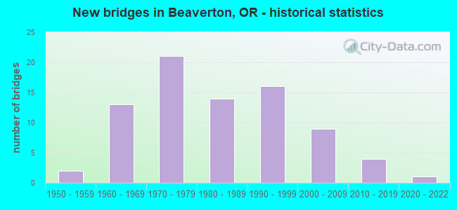
- New bridges - historical statistics
- 21950-1959
- 131960-1969
- 211970-1979
- 141980-1989
- 161990-1999
- 92000-2009
- 42010-2019
- 12020-2022
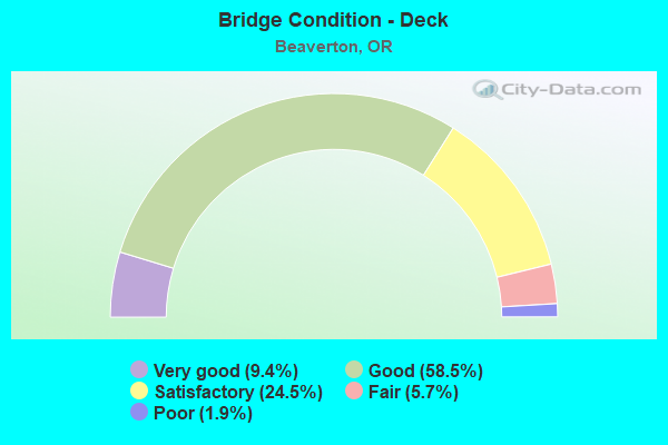
- Bridge Condition - Deck
- 9.4%Very good
- 58.5%Good
- 24.5%Satisfactory
- 5.7%Fair
- 1.9%Poor
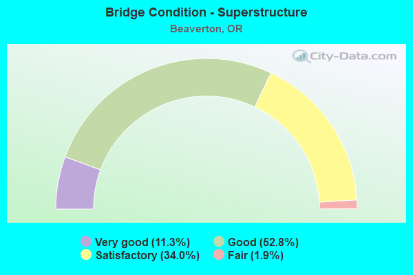
- Bridge Condition - Superstructure
- 11.3%Very good
- 52.8%Good
- 34.0%Satisfactory
- 1.9%Fair
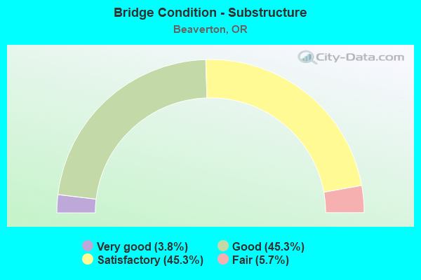
- Bridge Condition - Substructure
- 3.8%Very good
- 45.3%Good
- 45.3%Satisfactory
- 5.7%Fair
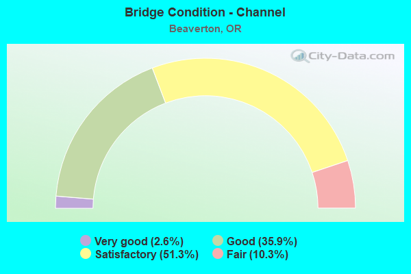
- Bridge Condition - Channel
- 2.6%Very good
- 35.9%Good
- 51.3%Satisfactory
- 10.3%Fair
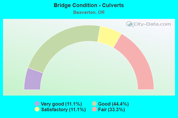
- Bridge Condition - Culverts
- 11.1%Very good
- 44.4%Good
- 11.1%Satisfactory
- 33.3%Fair
Find on map >> Show street view
Structure Number: 24007C250100129, Location: 05 MI WEST MURRAY BLVD (Lat: 45.506389, Lng: -122.836039), Route carried "on" structure: County highway C2501, Year Built: 2020, Status: Open, Structure Length: 1.78m (5.84ft), Average Daily Traffic: 21,818 (year 2020), Truck Traffic: 10%, Average Future Daily Traffic: 22,568 (year 2025), Design Load: HL 93, Features Intersected: CEDAR MILL CREEK, Facility Carried by Structure: JENKINS ROAD
Minimum Vertical Clearance: 30+ m (98+ ft), Kilometerpoint: 2.084, Lanes on structure: 4, Owner: County Highway Agency, Approaching Roadway Width: 13.7m (44.9ft), Skew: 1 degrees, Material/Design: Prestressed concrete, Design/Construction: Slab, Number Of Spans In Main Unit: 1, Length of Maximum Span: 17.8m (58.4ft), Curb or Sidewalk Widths: Left: 2.4m (7.9ft), Right: 2.4m (7.9ft), Curb-To-Curb Width: 24.8m (81.4ft), Out-to-Out Width: 30.5m (100.1ft)
Condition: Deck: Very good, Superstructure: Very good, Substructure: Good, Channel: Good, Operating Rating: 44.4 metric tons, Method Used To Determine Operating Rating: Load and Resistance Factor Rating (LRFR) rating reported by rating factor(RF) method using HL-93 loadings, Inventory Rating: 34.3 metric tons, Method Used To Determine Inventory Rating: Load and Resistance Factor Rating (LRFR) rating reported by rating factor(RF) method using HL-93 loadings, Structural Evaluation: Better than present minimum criteria, Deck Geometry: Superior to present desirable criteria, Waterway Adequacy: Equal to present minimum criteria, Approach Roadway Alignment: Equal to present desirable criteria, Designated Inspection Frequency: Every 24 months, Inspection Date: August 2021, Deck Structure Type: Other, Wearing Surface/Protective System: Wearing Surface: Bituminous, Membrane: Preformed Fabric
Find on map >> Show street view
Structure Number: 24053 001400304, Location: MP 3.04 (Lat: 45.518261, Lng: -122.798931), Route carried "on" structure: County highway 14, Year Built: 1995, Status: Open, Structure Length: 0.73m (2.40ft), Average Daily Traffic: 20,157 (year 2020), Truck Traffic: 5%, Average Future Daily Traffic: 20,442 (year 2025), Design Load: HL 93, Features Intersected: JOHNSON CREEK, Facility Carried by Structure: BARNES RD
Minimum Vertical Clearance: 30+ m (98+ ft), Kilometerpoint: 4.892, Lanes on structure: 4, Owner: County Highway Agency, Approaching Roadway Width: 19.5m (64.0ft), Material/Design: Concrete, Design/Construction: Culvert, Number Of Spans In Main Unit: 1, Length of Maximum Span: 6.1m (20.0ft)
Condition: Channel: Satisfactory, Culverts: Very good, Operating Rating: 68.0 metric tons, Method Used To Determine Operating Rating: No rating analysis performed, Inventory Rating: 40.8 metric tons, Method Used To Determine Inventory Rating: No rating analysis performed, Structural Evaluation: Equal to present desirable criteria, Waterway Adequacy: Equal to present desirable criteria, Approach Roadway Alignment: Equal to present desirable criteria, Designated Inspection Frequency: Every 24 months, Inspection Date: September 2021
Find on map >> Show street view
Structure Number: 6712022001, Location: 003 MI S SCHOLLS FERRY RD (Lat: 45.475469, Lng: -122.758103), Route carried "on" structure: County highway C2001, Year Built: 1962, Status: Posted for load, Structure Length: 0.70m (2.30ft), Average Daily Traffic: 3,115 (year 2020), Truck Traffic: 5%, Average Future Daily Traffic: 3,436 (year 2025), Design Load: HS 15, Features Intersected: FANNO CREEK, Facility Carried by Structure: NICOL RD
Minimum Vertical Clearance: 30+ m (98+ ft), Kilometerpoint: 0.000, Lanes on structure: 2, Owner: County Highway Agency, Approaching Roadway Width: 7.6m (24.9ft), Material/Design: Wood or Timber, Design/Construction: Stringer/Multi-beam, Number Of Spans In Main Unit: 1, Length of Maximum Span: 6.1m (20.0ft), Curb or Sidewalk Widths: Left: 0.0m, Right: 0.9m (3.0ft), Curb-To-Curb Width: 5.9m (19.4ft), Out-to-Out Width: 7.5m (24.6ft)
Condition: Deck: Satisfactory, Superstructure: Satisfactory, Substructure: Satisfactory, Channel: Satisfactory, Operating Rating: 18.5 metric tons, Method Used To Determine Operating Rating: Load and Resistance Factor Rating (LRFR) rating reported by rating factor(RF) method using HL-93 loadings, Inventory Rating: 14.3 metric tons, Method Used To Determine Inventory Rating: Load and Resistance Factor Rating (LRFR) rating reported by rating factor(RF) method using HL-93 loadings, Structural Evaluation: Meets minimum limits, Deck Geometry: High priority of replacement, Waterway Adequacy: Equal to present desirable criteria, Approach Roadway Alignment: Equal to present desirable criteria, Bridge Posting: Required (Relationship of Operating Rating to Maximum Legal Load: 20.0 - 29.9% below), Length Of Structure Improvement: 0.70m (2.30ft), Designated Inspection Frequency: Every 24 months, Inspection Date: August 2021, Bridge Improvement Cost: $74,000, Roadway Improvement Cost: $7,000, Total Project Cost: $118,000, Deck Structure Type: Wood or Timber, Wearing Surface/Protective System: Wearing Surface: Bituminous, Membrane: Built-up
Find on map >> Show street view
Structure Number: 6712031862, Location: 002 MI EAST OF 92ND AVE (Lat: 45.468278, Lng: -122.767344), Route carried "on" structure: County highway C1862, Year Built: 1957, Status: Posted for load, Structure Length: 1.43m (4.69ft), Average Daily Traffic: 282 (year 2020), Truck Traffic: 5%, Average Future Daily Traffic: 311 (year 2025), Design Load: HS 20, Features Intersected: FANNO CREEK, Facility Carried by Structure: BOHMANN PARKWAY
Minimum Vertical Clearance: 30+ m (98+ ft), Kilometerpoint: 0.000, Lanes on structure: 2, Owner: County Highway Agency, Approaching Roadway Width: 7.9m (25.9ft), Material/Design: Wood or Timber, Design/Construction: Stringer/Multi-beam, Number Of Spans In Main Unit: 3, Length of Maximum Span: 4.6m (15.1ft), Curb-To-Curb Width: 8.2m (26.9ft), Out-to-Out Width: 8.6m (28.2ft)
Condition: Deck: Good, Superstructure: Good, Substructure: Satisfactory, Channel: Satisfactory, Operating Rating: 18.1 metric tons, Method Used To Determine Operating Rating: Load and Resistance Factor Rating (LRFR) rating reported by rating factor(RF) method using HL-93 loadings, Inventory Rating: 13.9 metric tons, Method Used To Determine Inventory Rating: Load and Resistance Factor Rating (LRFR) rating reported by rating factor(RF) method using HL-93 loadings, Structural Evaluation: Meets minimum limits, Deck Geometry: Somewhat better than minimum adequacy, Waterway Adequacy: Equal to present desirable criteria, Approach Roadway Alignment: Equal to present desirable criteria, Bridge Posting: Required (Relationship of Operating Rating to Maximum Legal Load: 0.1 - 9.9% below), Designated Inspection Frequency: Every 24 months, Inspection Date: August 2020, Deck Structure Type: Wood or Timber, Wearing Surface/Protective System: Wearing Surface: Bituminous, Membrane: Built-up
Find on map >> Show street view
Structure Number: 67120412910031, Location: 003 MI S SCHOLLS FERRY RD (Lat: 45.469011, Lng: -122.771703), Route carried "on" structure: County highway C2092, Year Built: 1970, Status: Open, Structure Length: 1.52m (4.99ft), Average Daily Traffic: 16,592 (year 2020), Truck Traffic: 5%, Average Future Daily Traffic: 23,231 (year 2025), Design Load: HS 20, Features Intersected: FANNO CREEK, Facility Carried by Structure: SW 92ND AVE
Minimum Vertical Clearance: 30+ m (98+ ft), Kilometerpoint: 4.989, Lanes on structure: 2, Owner: County Highway Agency, Approaching Roadway Width: 6.4m (21.0ft), Skew: 2 degrees, Material/Design: Prestressed concrete, Design/Construction: Slab, Number Of Spans In Main Unit: 2, Length of Maximum Span: 7.6m (24.9ft), Curb or Sidewalk Widths: Left: 0.0m, Right: 1.1m (3.6ft), Curb-To-Curb Width: 8.2m (26.9ft), Out-to-Out Width: 9.8m (32.2ft)
Condition: Deck: Good, Superstructure: Satisfactory, Substructure: Satisfactory, Channel: Satisfactory, Operating Rating: 56.2 metric tons, Method Used To Determine Operating Rating: Load Factor (LF), Inventory Rating: 33.6 metric tons, Method Used To Determine Inventory Rating: Load Factor (LF), Structural Evaluation: Equal to present minimum criteria, Deck Geometry: High priority of replacement, Waterway Adequacy: Equal to present minimum criteria, Approach Roadway Alignment: Equal to present minimum criteria, Length Of Structure Improvement: 1.50m (4.92ft), Designated Inspection Frequency: Every 24 months, Inspection Date: August 2020, Bridge Improvement Cost: $160,000, Roadway Improvement Cost: $16,000, Total Project Cost: $256,000, Deck Structure Type: Other, Wearing Surface/Protective System: Wearing Surface: Bituminous
Find on map >> Show street view
Structure Number: 67120612650002, Location: 002 MI S SCHOLLS FERRY RD (Lat: 45.471214, Lng: -122.765289), Route carried "on" structure: County highway C1408, Year Built: 1960, Status: Open, Structure Length: 0.98m (3.22ft), Average Daily Traffic: 282 (year 2020), Truck Traffic: 5%, Average Future Daily Traffic: 311 (year 2025), Features Intersected: FANNO CREEK, Facility Carried by Structure: SW 86TH AVE
Minimum Vertical Clearance: 30+ m (98+ ft), Kilometerpoint: 0.000, Lanes on structure: 2, Owner: County Highway Agency, Approaching Roadway Width: 5.2m (17.1ft), Skew: 3 degrees, Material/Design: Wood or Timber, Design/Construction: Stringer/Multi-beam, Number Of Spans In Main Unit: 2, Length of Maximum Span: 4.6m (15.1ft), Curb-To-Curb Width: 5.3m (17.4ft), Out-to-Out Width: 5.7m (18.7ft)
Condition: Deck: Satisfactory, Superstructure: Good, Substructure: Satisfactory, Channel: Satisfactory, Operating Rating: 20.7 metric tons, Method Used To Determine Operating Rating: Load and Resistance Factor Rating (LRFR) rating reported by rating factor(RF) method using HL-93 loadings, Inventory Rating: 15.9 metric tons, Method Used To Determine Inventory Rating: Load and Resistance Factor Rating (LRFR) rating reported by rating factor(RF) method using HL-93 loadings, Structural Evaluation: Meets minimum limits, Deck Geometry: High priority of replacement, Waterway Adequacy: Equal to present desirable criteria, Approach Roadway Alignment: Equal to present desirable criteria, Length Of Structure Improvement: 1.00m (3.28ft), Designated Inspection Frequency: Every 24 months, Inspection Date: August 2021, Bridge Improvement Cost: $102,000, Roadway Improvement Cost: $10,000, Total Project Cost: $164,000, Deck Structure Type: Wood or Timber, Wearing Surface/Protective System: Wearing Surface: Bituminous, Membrane: Built-up
Find on map >> Show street view
Structure Number: 67123800090235, Location: 001 MI W MADELINE STREET (Lat: 45.481381, Lng: -122.867331), Route carried "on" structure: County highway C0300, Year Built: 1974, Status: Open, Structure Length: 0.85m (2.79ft), Average Daily Traffic: 21,545 (year 2020), Truck Traffic: 5%, Average Future Daily Traffic: 30,855 (year 2025), Design Load: HS 20, Features Intersected: BUTTERNUT CREEK, Facility Carried by Structure: 185TH AVE
Minimum Vertical Clearance: 30+ m (98+ ft), Kilometerpoint: 2.622, Lanes on structure: 2, Owner: County Highway Agency, Approaching Roadway Width: 11.0m (36.1ft), Skew: 4 degrees, Material/Design: Prestressed concrete, Design/Construction: Slab, Number Of Spans In Main Unit: 1, Length of Maximum Span: 7.9m (25.9ft), Curb or Sidewalk Widths: Left: 0.0m, Right: 1.3m (4.3ft), Curb-To-Curb Width: 9.8m (32.2ft), Out-to-Out Width: 12.2m (40.0ft)
Condition: Deck: Good, Superstructure: Good, Substructure: Satisfactory, Channel: Fair, Operating Rating: 41.7 metric tons, Method Used To Determine Operating Rating: Load Factor (LF), Inventory Rating: 24.5 metric tons, Method Used To Determine Inventory Rating: Load Factor (LF), Structural Evaluation: Equal to present minimum criteria, Deck Geometry: Meets minimum limits, Waterway Adequacy: Better than present minimum criteria, Approach Roadway Alignment: Equal to present desirable criteria, Designated Inspection Frequency: Every 24 months, Inspection Date: September 2020, Deck Structure Type: Other, Wearing Surface/Protective System: Wearing Surface: Bituminous
Find on map >> Show street view
Structure Number: 67123909910003, Location: 003 MI N ROSA ROAD (Lat: 45.483711, Lng: -122.875019), Route carried "on" structure: County highway C0755, Year Built: 1974, Status: Open, Structure Length: 0.79m (2.59ft), Average Daily Traffic: 1,274 (year 2020), Truck Traffic: 5%, Average Future Daily Traffic: 1,405 (year 2025), Design Load: HS 20, Features Intersected: BUTTERNUT CREEK, Facility Carried by Structure: SW 192ND AVENUE
Minimum Vertical Clearance: 30+ m (98+ ft), Kilometerpoint: 1.336, Lanes on structure: 2, Owner: County Highway Agency, Approaching Roadway Width: 7.3m (24.0ft), Material/Design: Wood or Timber, Design/Construction: Stringer/Multi-beam, Number Of Spans In Main Unit: 2, Length of Maximum Span: 3.7m (12.1ft), Curb-To-Curb Width: 7.1m (23.3ft), Out-to-Out Width: 7.4m (24.3ft)
Condition: Deck: Satisfactory, Superstructure: Satisfactory, Substructure: Fair, Channel: Fair, Operating Rating: 35.3 metric tons, Method Used To Determine Operating Rating: Load and Resistance Factor Rating (LRFR) rating reported by rating factor(RF) method using HL-93 loadings, Inventory Rating: 27.2 metric tons, Method Used To Determine Inventory Rating: Load and Resistance Factor Rating (LRFR) rating reported by rating factor(RF) method using HL-93 loadings, Structural Evaluation: Somewhat better than minimum adequacy, Deck Geometry: High priority of corrective action, Waterway Adequacy: Equal to present minimum criteria, Approach Roadway Alignment: Equal to present desirable criteria, Length Of Structure Improvement: 0.80m (2.62ft), Designated Inspection Frequency: Every 24 months, Inspection Date: September 2021, Bridge Improvement Cost: $83,000, Roadway Improvement Cost: $8,000, Total Project Cost: $133,000, Deck Structure Type: Wood or Timber, Wearing Surface/Protective System: Wearing Surface: Bituminous, Membrane: Built-up
Find on map >> Show street view
Structure Number: 6713300889001, Location: AT BASELINE ROAD (Lat: 45.515600, Lng: -122.867400), Route carried "on" structure: County highway C0300, Year Built: 1988, Status: Open, Structure Length: 1.01m (3.31ft), Average Daily Traffic: 21,247 (year 2020), Truck Traffic: 5%, Average Future Daily Traffic: 23,433 (year 2025), Design Load: HS 20, Features Intersected: WILLOW CREEK EB, Facility Carried by Structure: 185TH & BASELINE
Minimum Vertical Clearance: 30+ m (98+ ft), Kilometerpoint: 6.486, Lanes on structure: 10, Owner: County Highway Agency, Approaching Roadway Width: 25.0m (82.0ft), Skew: 4 degrees, Material/Design: Concrete continuous, Design/Construction: Culvert, Number Of Spans In Main Unit: 2, Length of Maximum Span: 4.6m (15.1ft), Curb or Sidewalk Widths: Left: 1.8m (5.9ft), Right: 1.8m (5.9ft)
Condition: Channel: Satisfactory, Culverts: Fair, Operating Rating: 42.4 metric tons, Method Used To Determine Operating Rating: Field evaluation and documented engineering judgment, Inventory Rating: 32.7 metric tons, Method Used To Determine Inventory Rating: Field evaluation and documented engineering judgment, Structural Evaluation: Somewhat better than minimum adequacy, Waterway Adequacy: Equal to present minimum criteria, Approach Roadway Alignment: Equal to present desirable criteria, Designated Inspection Frequency: Every 24 months, Underwater Inspection Frequency: Every 60 months, Inspection Date: September 2020, Underwater Inspection Date: Febuary 2019
Find on map >> Show street view
Structure Number: 67133311350008, Location: 0055 MI N HWY-8 (Lat: 45.500789, Lng: -122.851989), Route carried "on" structure: County highway C0955, Year Built: 1969, Status: Open, Structure Length: 1.52m (4.99ft), Average Daily Traffic: 18,596 (year 2020), Truck Traffic: 5%, Average Future Daily Traffic: 20,509 (year 2025), Design Load: HS 20, Features Intersected: BEAVERTON CREEK, Facility Carried by Structure: 170TH AVE
Minimum Vertical Clearance: 30+ m (98+ ft), Kilometerpoint: 4.347, Lanes on structure: 2, Owner: County Highway Agency, Approaching Roadway Width: 9.8m (32.2ft), Skew: 2 degrees, Material/Design: Prestressed concrete, Design/Construction: Slab, Number Of Spans In Main Unit: 2, Length of Maximum Span: 7.6m (24.9ft), Curb or Sidewalk Widths: Left: 1.1m (3.6ft), Right: 0.0m, Curb-To-Curb Width: 9.1m (29.9ft), Out-to-Out Width: 10.1m (33.1ft)
Condition: Deck: Good, Superstructure: Good, Substructure: Fair, Channel: Fair, Operating Rating: 58.1 metric tons, Method Used To Determine Operating Rating: Allowable Stress (AS), Inventory Rating: 34.5 metric tons, Method Used To Determine Inventory Rating: Allowable Stress (AS), Structural Evaluation: Somewhat better than minimum adequacy, Deck Geometry: High priority of corrective action, Waterway Adequacy: Equal to present minimum criteria, Approach Roadway Alignment: Equal to present desirable criteria, Length Of Structure Improvement: 1.50m (4.92ft), Designated Inspection Frequency: Every 24 months, Underwater Inspection Frequency: Every 36 months, Inspection Date: September 2020, Underwater Inspection Date: March 2021, Bridge Improvement Cost: $160,000, Roadway Improvement Cost: $16,000, Total Project Cost: $256,000, Deck Structure Type: Other, Wearing Surface/Protective System: Wearing Surface: Bituminous
Find on map >> Show street view
Structure Number: 671355C206, Location: 1 MI S/O HWY #26 (Lat: 45.509981, Lng: -122.822850), Route carried "on" structure: County highway C1735, Year Built: 1987, Status: Open, Structure Length: 2.04m (6.69ft), Average Daily Traffic: 28,683 (year 2020), Truck Traffic: 10%, Average Future Daily Traffic: 41,842 (year 2025), Design Load: HS 25 or greater, Features Intersected: CEDAR MILL CREEK, Facility Carried by Structure: SW MURRAY BLVD
Minimum Vertical Clearance: 30+ m (98+ ft), Kilometerpoint: 8.072, Lanes on structure: 5, Owner: County Highway Agency, Approaching Roadway Width: 23.8m (78.1ft), Skew: 1 degrees, Material/Design: Prestressed concrete, Design/Construction: Slab, Number Of Spans In Main Unit: 1, Length of Maximum Span: 20.1m (65.9ft), Curb or Sidewalk Widths: Left: 1.7m (5.6ft), Right: 1.7m (5.6ft), Curb-To-Curb Width: 23.8m (78.1ft), Out-to-Out Width: 28.3m (92.8ft)
Condition: Deck: Very good, Superstructure: Very good, Substructure: Good, Channel: Satisfactory, Operating Rating: 82.6 metric tons, Method Used To Determine Operating Rating: Allowable Stress (AS), Inventory Rating: 49.9 metric tons, Method Used To Determine Inventory Rating: Allowable Stress (AS), Structural Evaluation: Better than present minimum criteria, Deck Geometry: Better than present minimum criteria, Waterway Adequacy: Equal to present desirable criteria, Approach Roadway Alignment: Equal to present desirable criteria, Designated Inspection Frequency: Every 24 months, Inspection Date: September 2020, Deck Structure Type: Other, Wearing Surface/Protective System: Wearing Surface: Bituminous, Membrane: Preformed Fabric, Deck Protection: Epoxy Coated Reinforcing
Find on map >> Show street view
Structure Number: 67140011200001, Location: 0107 MI E MURRAY BLVD (Lat: 45.514219, Lng: -122.817719), Route carried "on" structure: County highway C0568, Year Built: 1987, Status: Open, Structure Length: 1.19m (3.90ft), Average Daily Traffic: 5,241 (year 2020), Truck Traffic: 5%, Average Future Daily Traffic: 5,936 (year 2025), Design Load: HS 25 or greater, Features Intersected: CEDAR MILL CREEK, Facility Carried by Structure: SW BUTNER ROAD
Minimum Vertical Clearance: 30+ m (98+ ft), Kilometerpoint: 3.026, Lanes on structure: 2, Owner: County Highway Agency, Approaching Roadway Width: 11.0m (36.1ft), Skew: 20 degrees, Material/Design: Prestressed concrete, Design/Construction: Slab, Number Of Spans In Main Unit: 1, Length of Maximum Span: 11.6m (38.1ft), Curb or Sidewalk Widths: Left: 1.6m (5.2ft), Right: 1.6m (5.2ft), Curb-To-Curb Width: 11.0m (36.1ft), Out-to-Out Width: 15.3m (50.2ft)
Condition: Deck: Very good, Superstructure: Very good, Substructure: Satisfactory, Channel: Satisfactory, Operating Rating: 69.9 metric tons, Method Used To Determine Operating Rating: Allowable Stress (AS), Inventory Rating: 41.7 metric tons, Method Used To Determine Inventory Rating: Allowable Stress (AS), Structural Evaluation: Equal to present minimum criteria, Deck Geometry: Meets minimum limits, Waterway Adequacy: Equal to present minimum criteria, Approach Roadway Alignment: Equal to present desirable criteria, Designated Inspection Frequency: Every 24 months, Inspection Date: September 2020, Deck Structure Type: Other, Wearing Surface/Protective System: Wearing Surface: Bituminous, Membrane: Preformed Fabric, Deck Protection: Epoxy Coated Reinforcing
Find on map >> Show street view
Structure Number: 6714082065, Location: 005 MI N HWY 8 (Lat: 45.497903, Lng: -122.828092), Route carried "on" structure: County highway C1735, Year Built: 1966, Status: Open, Structure Length: 9.86m (32.35ft), Average Daily Traffic: 15,795 (year 2020), Truck Traffic: 4%, Average Future Daily Traffic: 20,382 (year 2035), Design Load: HS 20, Features Intersected: BNRR & TERMAN ROAD, Facility Carried by Structure: SW MURRAY BLVD SB
Minimum Vertical Clearance: 30.17m (98.98ft), Kilometerpoint: 0.000, Lanes on structure: 2, Lanes under structure: 2, Owner: County Highway Agency, Approaching Roadway Width: 19.2m (63.0ft), Skew: 4 degrees, Material/Design: Prestressed concrete, Design/Construction: Stringer/Multi-beam, Number Of Spans In Main Unit: 4, Length of Maximum Span: 28.7m (94.2ft), Curb or Sidewalk Widths: Left: 0.0m, Right: 2.4m (7.9ft), Curb-To-Curb Width: 9.1m (29.9ft), Out-to-Out Width: 12.3m (40.4ft)
Condition: Deck: Fair, Superstructure: Good, Substructure: Good, Operating Rating: 9.4 metric tons, Method Used To Determine Operating Rating: Load and Resistance Factor Rating (LRFR) rating reported by rating factor(RF) method using HL-93 loadings, Inventory Rating: 7.1 metric tons, Method Used To Determine Inventory Rating: Load and Resistance Factor Rating (LRFR) rating reported by rating factor(RF) method using HL-93 loadings, Structural Evaluation: High priority of corrective action, Deck Geometry: Meets minimum limits, Underclear: Somewhat better than minimum adequacy, Approach Roadway Alignment: Equal to present desirable criteria, Designated Inspection Frequency: Every 24 months, Inspection Date: September 2020, Deck Structure Type: Concrete Cast-file-Place, Wearing Surface/Protective System: Wearing Surface: Monolithic Concrete
Find on map >> Show street view
Structure Number: 6714201430087, Location: 2.0 MI SW BEAVERTON CC (Lat: 45.446461, Lng: -122.791881), Route carried "on" structure: County highway C0348, Year Built: 1992, Status: Open, Structure Length: 1.71m (5.61ft), Average Daily Traffic: 33,891 (year 2020), Truck Traffic: 10%, Average Future Daily Traffic: 34,641 (year 2025), Design Load: HS 25 or greater, Features Intersected: FANNO CREEK, Facility Carried by Structure: SCHOLLS FERRY RD.
Minimum Vertical Clearance: 30+ m (98+ ft), Kilometerpoint: 0.000, Lanes on structure: 4, Owner: County Highway Agency, Approaching Roadway Width: 21.0m (68.9ft), Material/Design: Prestressed concrete, Design/Construction: Slab, Number Of Spans In Main Unit: 1, Length of Maximum Span: 16.8m (55.1ft), Curb or Sidewalk Widths: Left: 2.1m (6.9ft), Right: 2.3m (7.5ft), Curb-To-Curb Width: 20.9m (68.6ft), Out-to-Out Width: 25.9m (85.0ft)
Condition: Deck: Good, Superstructure: Good, Substructure: Good, Channel: Satisfactory, Operating Rating: 70.8 metric tons, Method Used To Determine Operating Rating: Allowable Stress (AS), Inventory Rating: 42.6 metric tons, Method Used To Determine Inventory Rating: Allowable Stress (AS), Structural Evaluation: Better than present minimum criteria, Deck Geometry: Superior to present desirable criteria, Waterway Adequacy: Equal to present minimum criteria, Approach Roadway Alignment: Equal to present desirable criteria, Designated Inspection Frequency: Every 24 months, Inspection Date: July 2020, Deck Structure Type: Other, Wearing Surface/Protective System: Wearing Surface: Bituminous
Find on map >> Show street view
Structure Number: BB001, Location: 001 N OF DENNEY RD (Lat: 45.469717, Lng: -122.788142), Route carried "on" structure: ServiceCity street C0000, Year Built: 1977, Status: Open, Structure Length: 1.01m (3.31ft), Average Daily Traffic: 16 (year 2020), Average Future Daily Traffic: 18 (year 2025), Design Load: HS 20, Features Intersected: FANNO CREEK, Facility Carried by Structure: DENNEY RD ACCESS N
Minimum Vertical Clearance: 30+ m (98+ ft), Kilometerpoint: 0.000, Lanes on structure: 2, Owner: City or Municipal Highway Agency, Approaching Roadway Width: 10.1m (33.1ft), Skew: 2 degrees, Material/Design: Prestressed concrete, Design/Construction: Slab, Number Of Spans In Main Unit: 1, Length of Maximum Span: 9.8m (32.2ft), Curb-To-Curb Width: 9.6m (31.5ft), Out-to-Out Width: 9.8m (32.2ft)
Condition: Deck: Good, Superstructure: Satisfactory, Substructure: Satisfactory, Channel: Satisfactory, Operating Rating: 76.2 metric tons, Method Used To Determine Operating Rating: Load Factor (LF), Inventory Rating: 45.4 metric tons, Method Used To Determine Inventory Rating: Load Factor (LF), Structural Evaluation: Equal to present minimum criteria, Deck Geometry: Better than present minimum criteria, Waterway Adequacy: Equal to present minimum criteria, Approach Roadway Alignment: Equal to present desirable criteria, Designated Inspection Frequency: Every 24 months, Inspection Date: July 2020, Deck Structure Type: Other, Wearing Surface/Protective System: Wearing Surface: Bituminous
Find on map >> Show street view
Structure Number: BB0016, Location: .2MI WEST OFF MURREY BLVD (Lat: 45.474697, Lng: -122.832447), Route carried "on" structure: City street , Year Built: 1997, Status: Open, Structure Length: 1.71m (5.61ft), Average Daily Traffic: 330 (year 2018), Truck Traffic: 22%, Average Future Daily Traffic: 340 (year 2038), Design Load: HS 25 or greater, Features Intersected: JOHNSON CREEK, Facility Carried by Structure: DAVIS RD
Minimum Vertical Clearance: 30+ m (98+ ft), Kilometerpoint: 0.000, Lanes on structure: 2, Owner: City or Municipal Highway Agency, Approaching Roadway Width: 11.0m (36.1ft), Material/Design: Prestressed concrete, Design/Construction: Slab, Number Of Spans In Main Unit: 1, Length of Maximum Span: 16.5m (54.1ft), Curb-To-Curb Width: 11.6m (38.1ft), Out-to-Out Width: 11.9m (39.0ft)
Condition: Deck: Good, Superstructure: Good, Substructure: Good, Channel: Satisfactory, Operating Rating: 79.8 metric tons, Method Used To Determine Operating Rating: Load Factor (LF), Inventory Rating: 48.1 metric tons, Method Used To Determine Inventory Rating: Load Factor (LF), Structural Evaluation: Better than present minimum criteria, Deck Geometry: Superior to present desirable criteria, Waterway Adequacy: High priority of corrective action, Approach Roadway Alignment: Better than present minimum criteria, Designated Inspection Frequency: Every 24 months, Inspection Date: July 2020, Deck Structure Type: Concrete Cast-file-Place, Wearing Surface/Protective System: Wearing Surface: Monolithic Concrete, Deck Protection: Epoxy Coated Reinforcing
Find on map >> Show street view
Structure Number: BB002, Location: 001 S OF DENNEY RD (Lat: 45.468900, Lng: -122.788700), Route carried "on" structure: Business City street C0000, Year Built: 1977, Status: Open, Structure Length: 0.91m (2.99ft), Average Daily Traffic: 2,125 (year 2020), Truck Traffic: 5%, Average Future Daily Traffic: 2,344 (year 2025), Design Load: HS 20, Features Intersected: FANNO CREEK, Facility Carried by Structure: DENNEY RD ACCESS S
Minimum Vertical Clearance: 30+ m (98+ ft), Kilometerpoint: 0.000, Lanes on structure: 2, Owner: City or Municipal Highway Agency, Approaching Roadway Width: 10.4m (34.1ft), Material/Design: Prestressed concrete, Design/Construction: Slab, Number Of Spans In Main Unit: 1, Length of Maximum Span: 8.5m (27.9ft), Curb-To-Curb Width: 9.6m (31.5ft), Out-to-Out Width: 9.8m (32.2ft)
Condition: Deck: Good, Superstructure: Good, Substructure: Satisfactory, Channel: Satisfactory, Operating Rating: 75.3 metric tons, Method Used To Determine Operating Rating: Load Factor (LF), Inventory Rating: 45.4 metric tons, Method Used To Determine Inventory Rating: Load Factor (LF), Structural Evaluation: Equal to present minimum criteria, Deck Geometry: Meets minimum limits, Waterway Adequacy: Equal to present minimum criteria, Approach Roadway Alignment: Equal to present desirable criteria, Designated Inspection Frequency: Every 24 months, Inspection Date: July 2020, Deck Structure Type: Other, Wearing Surface/Protective System: Wearing Surface: Bituminous
Find on map >> Show street view
Structure Number: BB004 909100217, Location: 002 E OF GREENWAY BLVD (Lat: 45.460847, Lng: -122.794614), Route carried "on" structure: City street C0000, Year Built: 1981, Status: Open, Structure Length: 1.49m (4.89ft), Average Daily Traffic: 35,412 (year 2020), Truck Traffic: 5%, Average Future Daily Traffic: 39,055 (year 2025), Design Load: HS 20, Features Intersected: FANNO CREEK, Facility Carried by Structure: HALL BLVD
Minimum Vertical Clearance: 30+ m (98+ ft), Kilometerpoint: 0.000, Lanes on structure: 5, Owner: City or Municipal Highway Agency, Approaching Roadway Width: 18.9m (62.0ft), Material/Design: Prestressed concrete, Design/Construction: Slab, Number Of Spans In Main Unit: 1, Length of Maximum Span: 14.6m (47.9ft), Curb or Sidewalk Widths: Left: 2.1m (6.9ft), Right: 2.1m (6.9ft), Curb-To-Curb Width: 21.0m (68.9ft), Out-to-Out Width: 25.3m (83.0ft)
Condition: Deck: Good, Superstructure: Good, Substructure: Good, Channel: Satisfactory, Operating Rating: 56.2 metric tons, Method Used To Determine Operating Rating: Load Factor (LF), Inventory Rating: 29.0 metric tons, Method Used To Determine Inventory Rating: Load Factor (LF), Structural Evaluation: Better than present minimum criteria, Deck Geometry: Somewhat better than minimum adequacy, Waterway Adequacy: Equal to present desirable criteria, Approach Roadway Alignment: Equal to present desirable criteria, Designated Inspection Frequency: Every 24 months, Inspection Date: July 2020, Deck Structure Type: Other, Wearing Surface/Protective System: Wearing Surface: Bituminous
Find on map >> Show street view
Structure Number: BB005 083800034, Location: 0034 N OF TV HWY (Lat: 45.493211, Lng: -122.810550), Route carried "on" structure: City street C0000, Year Built: 1959, Status: Open, Structure Length: 1.59m (5.22ft), Average Daily Traffic: 13,600 (year 2014), Truck Traffic: 5%, Average Future Daily Traffic: 34,421 (year 2030), Design Load: HS 20, Features Intersected: BEAVERTON CREEK, Facility Carried by Structure: CEDAR HILLS BLVD
Minimum Vertical Clearance: 30+ m (98+ ft), Kilometerpoint: 0.547, Lanes on structure: 5, Owner: City or Municipal Highway Agency, Approaching Roadway Width: 17.1m (56.1ft), Material/Design: Concrete continuous, Design/Construction: Slab, Number Of Spans In Main Unit: 3, Length of Maximum Span: 5.8m (19.0ft), Curb or Sidewalk Widths: Left: 1.6m (5.2ft), Right: 1.5m (4.9ft), Curb-To-Curb Width: 17.2m (56.4ft), Out-to-Out Width: 20.8m (68.2ft)
Condition: Deck: Satisfactory, Superstructure: Satisfactory, Substructure: Fair, Channel: Fair, Operating Rating: 58.1 metric tons, Method Used To Determine Operating Rating: Allowable Stress (AS), Inventory Rating: 34.5 metric tons, Method Used To Determine Inventory Rating: Allowable Stress (AS), Structural Evaluation: Somewhat better than minimum adequacy, Deck Geometry: High priority of replacement, Waterway Adequacy: Equal to present desirable criteria, Approach Roadway Alignment: Equal to present desirable criteria, Length Of Structure Improvement: 1.60m (5.25ft), Designated Inspection Frequency: Every 24 months, Inspection Date: September 2020, Bridge Improvement Cost: $167,000, Roadway Improvement Cost: $17,000, Total Project Cost: $266,000, Deck Structure Type: Concrete Cast-file-Place, Wearing Surface/Protective System: Wearing Surface: Bituminous
Find on map >> Show street view
Structure Number: BB009, Location: 003 MI N TV HWY (Lat: 45.491381, Lng: -122.805750), Route carried "on" structure: City street C0000, Year Built: 1969, Status: Open, Structure Length: 2.26m (7.41ft), Average Daily Traffic: 13,469 (year 2020), Truck Traffic: 5%, Average Future Daily Traffic: 14,855 (year 2025), Design Load: HS 20, Features Intersected: BEAVERTON CREEK, Facility Carried by Structure: S.W. HALL BLVD
Minimum Vertical Clearance: 30+ m (98+ ft), Kilometerpoint: 0.000, Lanes on structure: 4, Owner: City or Municipal Highway Agency, Approaching Roadway Width: 14.6m (47.9ft), Skew: 5 degrees, Material/Design: Prestressed concrete, Design/Construction: Slab, Number Of Spans In Main Unit: 3, Length of Maximum Span: 7.3m (24.0ft), Curb or Sidewalk Widths: Left: 1.2m (3.9ft), Right: 1.2m (3.9ft), Curb-To-Curb Width: 14.6m (47.9ft), Out-to-Out Width: 18.3m (60.0ft)
Condition: Deck: Good, Superstructure: Good, Substructure: Satisfactory, Channel: Satisfactory, Operating Rating: 56.2 metric tons, Method Used To Determine Operating Rating: Allowable Stress (AS), Inventory Rating: 33.6 metric tons, Method Used To Determine Inventory Rating: Allowable Stress (AS), Structural Evaluation: Equal to present minimum criteria, Deck Geometry: High priority of replacement, Waterway Adequacy: Equal to present minimum criteria, Approach Roadway Alignment: Equal to present desirable criteria, Length Of Structure Improvement: 2.30m (7.55ft), Designated Inspection Frequency: Every 24 months, Inspection Date: September 2021, Bridge Improvement Cost: $237,000, Roadway Improvement Cost: $24,000, Total Project Cost: $379,000, Deck Structure Type: Other, Wearing Surface/Protective System: Wearing Surface: Bituminous
Find on map >> Show street view
Structure Number: BB014, Location: 001 MI N TV HWY (Lat: 45.493139, Lng: -122.832419), Route carried "on" structure: City street C0000, Year Built: 1985, Status: Open, Structure Length: 3.14m (10.30ft), Average Daily Traffic: 2,833 (year 2020), Truck Traffic: 5%, Average Future Daily Traffic: 3,125 (year 2025), Design Load: HS 20, Features Intersected: BEAVERTON CREEK, Facility Carried by Structure: 153RD AVE
Minimum Vertical Clearance: 30+ m (98+ ft), Kilometerpoint: 0.000, Lanes on structure: 2, Owner: City or Municipal Highway Agency, Approaching Roadway Width: 10.1m (33.1ft), Skew: 3 degrees, Material/Design: Prestressed concrete, Design/Construction: Slab, Number Of Spans In Main Unit: 2, Length of Maximum Span: 17.1m (56.1ft), Curb or Sidewalk Widths: Left: 1.5m (4.9ft), Right: 1.5m (4.9ft), Curb-To-Curb Width: 10.2m (33.5ft), Out-to-Out Width: 14.7m (48.2ft)
Condition: Deck: Good, Superstructure: Good, Substructure: Satisfactory, Channel: Good, Operating Rating: 53.5 metric tons, Method Used To Determine Operating Rating: Allowable Stress (AS), Inventory Rating: 32.7 metric tons, Method Used To Determine Inventory Rating: Allowable Stress (AS), Structural Evaluation: Equal to present minimum criteria, Deck Geometry: Meets minimum limits, Waterway Adequacy: Equal to present desirable criteria, Approach Roadway Alignment: Better than present minimum criteria, Designated Inspection Frequency: Every 24 months, Underwater Inspection Frequency: Every 60 months, Inspection Date: September 2020, Underwater Inspection Date: March 2020, Deck Structure Type: Other, Wearing Surface/Protective System: Wearing Surface: Latex Concrete
Find on map >> Show street view
Structure Number: BB015, Location: 002 N TUALATIN VALLEY HWY (Lat: 45.494019, Lng: -122.839911), Route carried "on" structure: City street C0000, Year Built: 1984, Status: Open, Structure Length: 3.69m (12.11ft), Average Daily Traffic: 7,083 (year 2020), Truck Traffic: 5%, Average Future Daily Traffic: 7,812 (year 2025), Design Load: HS 20, Features Intersected: BEAVERTON CREEK, Facility Carried by Structure: MILLIKAN WAY
Minimum Vertical Clearance: 30+ m (98+ ft), Kilometerpoint: 0.322, Lanes on structure: 4, Owner: City or Municipal Highway Agency, Approaching Roadway Width: 15.9m (52.2ft), Material/Design: Concrete continuous, Design/Construction: Slab, Number Of Spans In Main Unit: 3, Length of Maximum Span: 12.2m (40.0ft), Curb or Sidewalk Widths: Left: 2.6m (8.5ft), Right: 2.6m (8.5ft), Curb-To-Curb Width: 16.0m (52.5ft), Out-to-Out Width: 21.5m (70.5ft)
Condition: Deck: Satisfactory, Superstructure: Good, Substructure: Good, Channel: Good, Operating Rating: 27.9 metric tons, Method Used To Determine Operating Rating: Load and Resistance Factor Rating (LRFR) rating reported by rating factor(RF) method using HL-93 loadings, Inventory Rating: 21.4 metric tons, Method Used To Determine Inventory Rating: Load and Resistance Factor Rating (LRFR) rating reported by rating factor(RF) method using HL-93 loadings, Structural Evaluation: Somewhat better than minimum adequacy, Deck Geometry: Meets minimum limits, Waterway Adequacy: Better than present minimum criteria, Approach Roadway Alignment: Equal to present minimum criteria, Designated Inspection Frequency: Every 24 months, Inspection Date: September 2020, Deck Structure Type: Concrete Cast-file-Place, Wearing Surface/Protective System: Wearing Surface: Monolithic Concrete
Find on map >> Show street view
Structure Number: BC001, Location: 001 WEST OF MURRY RD (Lat: 45.495450, Lng: -122.830100), Route carried "on" structure: Business City street C0000, Year Built: 1982, Status: Open, Structure Length: 2.01m (6.59ft), Average Daily Traffic: 7,789 (year 2020), Truck Traffic: 5%, Average Future Daily Traffic: 8,590 (year 2025), Design Load: HS 20, Features Intersected: BEAVERTON CREEK, Facility Carried by Structure: MILLIKAN ST
Minimum Vertical Clearance: 30+ m (98+ ft), Kilometerpoint: 0.000, Lanes on structure: 4, Owner: City or Municipal Highway Agency, Approaching Roadway Width: 20.1m (65.9ft), Material/Design: Steel, Design/Construction: Culvert, Number Of Spans In Main Unit: 5, Length of Maximum Span: 3.0m (9.8ft), Curb or Sidewalk Widths: Left: 2.1m (6.9ft), Right: 1.5m (4.9ft)
Condition: Channel: Satisfactory, Culverts: Fair, Operating Rating: 89.7 metric tons, Method Used To Determine Operating Rating: Load and Resistance Factor Rating (LRFR) rating reported by rating factor(RF) method using HL-93 loadings, Inventory Rating: 69.0 metric tons, Method Used To Determine Inventory Rating: Load and Resistance Factor Rating (LRFR) rating reported by rating factor(RF) method using HL-93 loadings, Structural Evaluation: Somewhat better than minimum adequacy, Waterway Adequacy: Equal to present desirable criteria, Approach Roadway Alignment: Equal to present desirable criteria, Designated Inspection Frequency: Every 24 months, Underwater Inspection Frequency: Every 60 months, Inspection Date: August 2020, Underwater Inspection Date: Febuary 2019
Find on map >> Show street view
Structure Number: BC007, Location: 001 NORTH OF CANYON ROAD (Lat: 45.490122, Lng: -122.801717), Route carried "on" structure: Business City street C0000, Year Built: 1988, Status: Open, Structure Length: 1.06m (3.48ft), Average Daily Traffic: 2,833 (year 2020), Truck Traffic: 10%, Average Future Daily Traffic: 3,125 (year 2025), Design Load: HS 25 or greater, Features Intersected: BEAVERTON CREEK, Facility Carried by Structure: LOMBARD EXTENSION
Minimum Vertical Clearance: 30+ m (98+ ft), Kilometerpoint: 0.000, Lanes on structure: 3, Owner: City or Municipal Highway Agency, Approaching Roadway Width: 12.2m (40.0ft), Skew: 3 degrees, Material/Design: Concrete, Design/Construction: Culvert, Number Of Spans In Main Unit: 1, Length of Maximum Span: 10.6m (34.8ft), Curb or Sidewalk Widths: Left: 2.6m (8.5ft), Right: 2.6m (8.5ft), Out-to-Out Width: 18.0m (59.1ft)
Condition: Channel: Good, Culverts: Satisfactory, Operating Rating: 18.8 metric tons, Method Used To Determine Operating Rating: Load and Resistance Factor Rating (LRFR) rating reported by rating factor(RF) method using HL-93 loadings, Inventory Rating: 14.6 metric tons, Method Used To Determine Inventory Rating: Load and Resistance Factor Rating (LRFR) rating reported by rating factor(RF) method using HL-93 loadings, Structural Evaluation: Meets minimum limits, Waterway Adequacy: Equal to present desirable criteria, Approach Roadway Alignment: Equal to present desirable criteria, Designated Inspection Frequency: Every 24 months, Inspection Date: September 2020
Find on map >> Show street view
Structure Number: 6980A047 06919, Location: 5.3 MI W OF PORTLAND CC (Lat: 45.508425, Lng: -122.778267), Route carried "under" structure: State highway 217, Year Built: 1986, Structure Length: 0. m, Average Daily Traffic: 88,423 (year 2020), Truck Traffic: 3%, Features Intersected: HWY 144, Facility Carried by Structure: US 26 (HWY 047)
Minimum Vertical Clearance: 30+ m (98+ ft), Kilometerpoint: 0.016, Lanes on structure: 9, Lanes under structure: 8, Material/Design: Prestressed concrete, Design/Construction: Slab, Length of Maximum Span: 27.3m (89.6ft)
Find on map >> Show street view
Structure Number: 8404A047C06715, Location: 7.2 MI W OF PORTLAND CC (Lat: 45.522311, Lng: -122.815761), Route carried "under" structure: US 26, Year Built: 1991, Structure Length: 0. m, Average Daily Traffic: 7,649 (year 2020), Truck Traffic: 13%, Features Intersected: HWY 47 US 26, Facility Carried by Structure: MURRAY BLVD CO
Minimum Vertical Clearance: 5.18m (16.99ft), Kilometerpoint: 0.000, Lanes on structure: 4, Lanes under structure: 6, Material/Design: Prestressed concrete continuous, Design/Construction: Stringer/Multi-beam, Length of Maximum Span: 38.4m (126.0ft)
Find on map >> Show street view
Structure Number: 8910A047 06601, Location: 8.6 MI W OF PORTLAND CC (Lat: 45.530769, Lng: -122.838050), Route carried "under" structure: US 26, Year Built: 1993, Structure Length: 0. m, Average Daily Traffic: 117,563 (year 2020), Truck Traffic: 5%, Features Intersected: Hwy 47 US 26, Facility Carried by Structure: Cornell Road
Minimum Vertical Clearance: 30+ m (98+ ft), Kilometerpoint: 106.233, Lanes on structure: 4, Lanes under structure: 4, Material/Design: Prestressed concrete continuous, Design/Construction: Stringer/Multi-beam, Length of Maximum Span: 42.7m (140.1ft)
Find on map >> Show street view
Structure Number: 9045 144 00207, Location: 0.4 MI N OF ALLEN BLVD (Lat: 45.481989, Lng: -122.792661), Route carried "under" structure: City street , Year Built: 1968, Structure Length: 0. m, Average Daily Traffic: 119,200 (year 2010), Truck Traffic: 5%, Features Intersected: PNWR, Facility Carried by Structure: OR 217 (HWY 144)
Minimum Vertical Clearance: 7.14m (23.43ft), Kilometerpoint: 0.000, Lanes on structure: 6, Lanes under structure: 2, Material/Design: Prestressed concrete, Design/Construction: Stringer/Multi-beam, Length of Maximum Span: 29.3m (96.1ft)
Find on map >> Show street view
Structure Number: 9607 144 00011, Location: SUNSET INTERCHANGE (Lat: 45.507086, Lng: -122.779622), Route carried "under" structure: State highway 217, Year Built: 1971, Structure Length: 0. m, Average Daily Traffic: 88,423 (year 2020), Truck Traffic: 3%, Features Intersected: HWY 144, Facility Carried by Structure: CONN 2 (PARKWAY)CO
Minimum Vertical Clearance: 5.66m (18.57ft), Kilometerpoint: 0.177, Lanes on structure: 2, Lanes under structure: 6, Material/Design: Concrete continuous, Design/Construction: Box Beam or Girders - Multiple, Length of Maximum Span: 25.9m (85.0ft)
Find on map >> Show street view
Structure Number: 9608 144 00019, Location: 1.3 MI N OF HWY 29 (Lat: 45.506033, Lng: -122.780253), Route carried "under" structure: State highway 217, Year Built: 1971, Structure Length: 0. m, Average Daily Traffic: 44,211 (year 2020), Truck Traffic: 3%, Features Intersected: HWY 144, Facility Carried by Structure: SW WILSHIRE
Minimum Vertical Clearance: 6.43m (21.10ft), Kilometerpoint: 0.306, Lanes on structure: 4, Lanes under structure: 6, Material/Design: Concrete continuous, Design/Construction: Box Beam or Girders - Multiple, Length of Maximum Span: 35.2m (115.5ft)
Find on map >> Show street view
Structure Number: 9608 144 00019, Location: 1.3 MI N OF HWY 29 (Lat: 45.506033, Lng: -122.780253), Route carried "under" structure: Ramp State highway 217, Year Built: 1971, Structure Length: 0. m, Average Daily Traffic: 88,423 (year 2020), Truck Traffic: 3%, Features Intersected: HWY 144, Facility Carried by Structure: SW WILSHIRE
Minimum Vertical Clearance: 6.43m (21.10ft), Kilometerpoint: 0.306, Lanes on structure: 4, Lanes under structure: 2, Material/Design: Concrete continuous, Design/Construction: Box Beam or Girders - Multiple, Length of Maximum Span: 35.2m (115.5ft)
Find on map >> Show street view
Structure Number: 9609 144 00118, Location: 0.3 MI N OF HWY 29 (Lat: 45.494850, Lng: -122.791481), Route carried "under" structure: State highway 217, Year Built: 1971, Structure Length: 0. m, Average Daily Traffic: 93,867 (year 2020), Truck Traffic: 3%, Features Intersected: HWY 144, Facility Carried by Structure: CABOT STREET
Minimum Vertical Clearance: 6.04m (19.82ft), Kilometerpoint: 1.899, Lanes on structure: 2, Lanes under structure: 6, Material/Design: Prestressed concrete, Design/Construction: Box Beam or Girders - Multiple, Length of Maximum Span: 48.8m (160.1ft)
Find on map >> Show street view
Structure Number: 9611 144 00147, Location: 1.0 MI N OF ALLEN BLVD (Lat: 45.490742, Lng: -122.792172), Route carried "under" structure: State highway 8, Year Built: 1971, Structure Length: 0. m, Average Daily Traffic: 28,762 (year 2020), Truck Traffic: 3%, Features Intersected: HWY 29 TV HWY, Facility Carried by Structure: OR 217 (HWY 144)
Minimum Vertical Clearance: 30+ m (98+ ft), Kilometerpoint: 4.667, Lanes on structure: 4, Lanes under structure: 6, Material/Design: Concrete continuous, Design/Construction: Box Beam or Girders - Multiple, Length of Maximum Span: 30.5m (100.1ft)
Find on map >> Show street view
Structure Number: 9612 144 00176, Location: 0.3 MI N OF SPRR (Lat: 45.486561, Lng: -122.792911), Route carried "under" structure: State highway 10, Year Built: 1971, Structure Length: 0. m, Average Daily Traffic: 29,390 (year 2020), Truck Traffic: 3%, Features Intersected: HWY 40 ORE 10, Facility Carried by Structure: OR 217 (HWY 144)
Minimum Vertical Clearance: 5.31m (17.42ft), Kilometerpoint: 1.625, Lanes on structure: 4, Lanes under structure: 6, Material/Design: Concrete continuous, Design/Construction: Box Beam or Girders - Multiple, Length of Maximum Span: 28.3m (92.8ft)
Find on map >> Show street view
Structure Number: 9671 141 00271, Location: 0.1 MI S OF HWY 143 JCT (Lat: 45.457861, Lng: -122.784642), Route carried "under" structure: State highway 217, Year Built: 1968, Structure Length: 0. m, Average Daily Traffic: 81,951 (year 2020), Truck Traffic: 3%, Features Intersected: HWY 144, Facility Carried by Structure: HWY 141
Minimum Vertical Clearance: 5.03m (16.50ft), Kilometerpoint: 6.148, Lanes on structure: 4, Lanes under structure: 6, Material/Design: Concrete continuous, Design/Construction: Box Beam or Girders - Multiple, Length of Maximum Span: 36.3m (119.1ft)
Find on map >> Show street view
Structure Number: 9672 143 0092, Location: 1.5 MI SW BEAVERTON CC (Lat: 45.451461, Lng: -122.784511), Route carried "under" structure: State highway 217, Year Built: 1968, Structure Length: 0. m, Average Daily Traffic: 93,779 (year 2020), Truck Traffic: 3%, Features Intersected: HWY 144, Facility Carried by Structure: OR 210 (HWY 143)
Minimum Vertical Clearance: 6.93m (22.74ft), Kilometerpoint: 6.872, Lanes on structure: 4, Lanes under structure: 4, Material/Design: Concrete continuous, Design/Construction: Box Beam or Girders - Multiple, Length of Maximum Span: 36.6m (120.1ft)
Find on map >> Show street view
Structure Number: 13494 144C00092, Location: 0.6 MI N OF HWY 29 (Lat: 45.498700, Lng: -122.790600), Route carried "under" structure: State highway 217, Year Built: 1972, Structure Length: 0. m, Average Daily Traffic: 93,867 (year 2020), Truck Traffic: 3%, Features Intersected: HWY 144, Facility Carried by Structure: WALKER ROAD
Minimum Vertical Clearance: 6.96m (22.83ft), Kilometerpoint: 1.481, Lanes on structure: 3, Lanes under structure: 5, Material/Design: Prestressed concrete, Design/Construction: Box Beam or Girders - Multiple, Length of Maximum Span: 47.5m (155.8ft)
Find on map >> Show street view
Structure Number: 16134 144C00248, Location: 0.3 MI S OF CABOT ST (Lat: 45.476631, Lng: -122.789453), Route carried "under" structure: State highway 217, Year Built: 1981, Structure Length: 0. m, Average Daily Traffic: 97,879 (year 2020), Truck Traffic: 3%, Features Intersected: HWY 144, Facility Carried by Structure: ALLEN BLVD
Minimum Vertical Clearance: 6.48m (21.26ft), Kilometerpoint: 3.991, Lanes on structure: 7, Lanes under structure: 4, Material/Design: Concrete continuous, Design/Construction: Box Beam or Girders - Multiple, Length of Maximum Span: 37.9m (124.3ft)
Find on map >> Show street view
Structure Number: 16143 144C00302, Location: 2.8 MI NW TIGARD CC (Lat: 45.469389, Lng: -122.786394), Route carried "under" structure: State highway 217, Year Built: 1978, Structure Length: 0. m, Average Daily Traffic: 97,468 (year 2020), Truck Traffic: 3%, Features Intersected: HWY 144, Facility Carried by Structure: DENNY RD & RAMP
Minimum Vertical Clearance: 7.21m (23.65ft), Kilometerpoint: 4.860, Lanes on structure: 5, Lanes under structure: 4, Material/Design: Concrete continuous, Design/Construction: Box Beam or Girders - Multiple, Length of Maximum Span: 33.5m (109.9ft)
Find on map >> Show street view
Structure Number: 16966 047 06567, Location: 8.8 MI W OF PORTLAND CC (Lat: 45.532369, Lng: -122.842361), Route carried "under" structure: US 26, Year Built: 1991, Structure Length: 0. m, Average Daily Traffic: 117,563 (year 2020), Truck Traffic: 5%, Features Intersected: Hwy 47 (US 26), Facility Carried by Structure: Bethany Blvd.
Minimum Vertical Clearance: 30+ m (98+ ft), Kilometerpoint: 105.686, Lanes on structure: 3, Lanes under structure: 4, Material/Design: Prestressed concrete continuous, Design/Construction: Stringer/Multi-beam, Length of Maximum Span: 39.6m (129.9ft)
Find on map >> Show street view
Structure Number: 19188 2065, Location: 005 MI N HWY 8 (Lat: 45.497844, Lng: -122.827919), Route carried "under" structure: City street , Year Built: 1999, Structure Length: 0. m, Average Daily Traffic: 1,000 (year 2010), Truck Traffic: 1%, Features Intersected: BNRR & TERMAN ROAD, Facility Carried by Structure: SW MURRAY BLVD NB
Minimum Vertical Clearance: 5.49m (18.01ft), Kilometerpoint: 0.000, Lanes on structure: 2, Lanes under structure: 2, Material/Design: Prestressed concrete continuous, Design/Construction: Stringer/Multi-beam, Length of Maximum Span: 28.7m (94.2ft)
Find on map >> Show street view
Structure Number: 6714082065, Location: 005 MI N HWY 8 (Lat: 45.497903, Lng: -122.828092), Route carried "under" structure: County highway , Year Built: 1966, Structure Length: 0. m, Average Daily Traffic: 1,000 (year 2010), Truck Traffic: 1%, Features Intersected: BNRR & TERMAN ROAD, Facility Carried by Structure: SW MURRAY BLVD SB
Minimum Vertical Clearance: 5.49m (18.01ft), Kilometerpoint: 0.000, Lanes on structure: 2, Lanes under structure: 2, Material/Design: Prestressed concrete, Design/Construction: Stringer/Multi-beam, Length of Maximum Span: 28.7m (94.2ft)