Bridge Statistics for Bedford, New Hampshire (NH)
Condition, Traffic, Stress, Structural Evaluation, Project Costs
- National Bridge Inventory (NBI) Statistics
- 37Number of bridges
- 551ft / 168mTotal length
- $72,266,000Total costs
- 640,535Total average daily traffic
- 43,730Total average daily truck traffic
- National Bridge Inventory (NBI) Registered Bridges for Bedford
- No street view available for this location
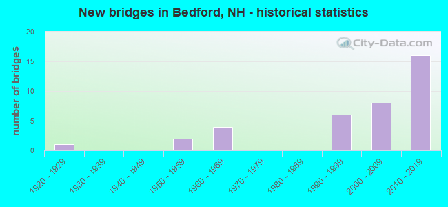
- New bridges - historical statistics
- 11920-1929
- 21950-1959
- 41960-1969
- 61990-1999
- 82000-2009
- 162010-2019
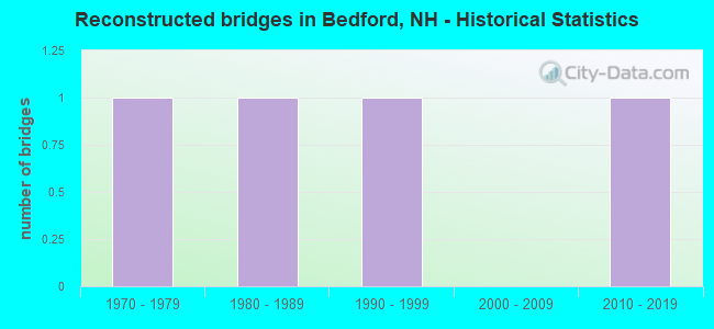
- Reconstructed bridges - Historical Statistics
- 11970-1979
- 11980-1989
- 11990-1999
- 02000-2009
- 12010-2019
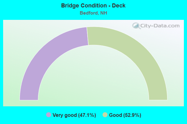
- Bridge Condition - Deck
- 47.1%Very good
- 52.9%Good
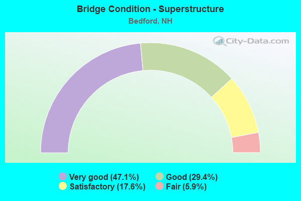
- Bridge Condition - Superstructure
- 47.1%Very good
- 29.4%Good
- 17.6%Satisfactory
- 5.9%Fair
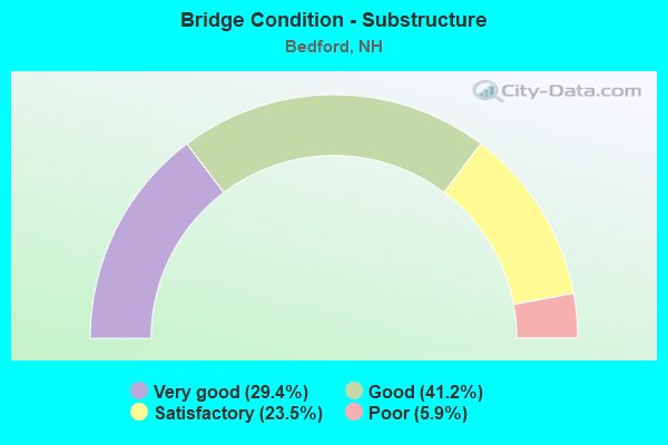
- Bridge Condition - Substructure
- 29.4%Very good
- 41.2%Good
- 23.5%Satisfactory
- 5.9%Poor
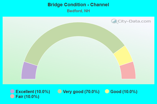
- Bridge Condition - Channel
- 10.0%Excellent
- 70.0%Very good
- 10.0%Good
- 10.0%Fair
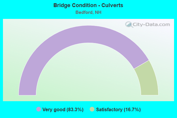
- Bridge Condition - Culverts
- 83.3%Very good
- 16.7%Satisfactory
Find on map >> Show street view
Structure Number: 19010500055, Location: 33 FT FR MERRIMACK TL (Lat: 42.898194, Lng: -71.555419), Route carried "on" structure: Other road , Year Built: 1928, Year Reconstructed: 1984, Status: Open, Structure Length: 0.70m (2.30ft), Average Daily Traffic: 431 (year 2020), Truck Traffic: 4%, Average Future Daily Traffic: 637 (year 2042), Design Load: H 20, Features Intersected: BABOOSIC BROOK, Facility Carried by Structure: BEALS ROAD
Minimum Vertical Clearance: 30+ m (98+ ft), Kilometerpoint: 1.611, Lanes on structure: 2, Owner: City or Municipal Highway Agency, Approaching Roadway Width: 5.5m (18.0ft), Material/Design: Concrete, Design/Construction: Slab, Number Of Spans In Main Unit: 1, Length of Maximum Span: 6.1m (20.0ft), Curb-To-Curb Width: 6.1m (20.0ft), Out-to-Out Width: 7.0m (23.0ft)
Condition: Deck: Good, Superstructure: Good, Substructure: Poor, Channel: Good, Operating Rating: 57.2 metric tons, Method Used To Determine Operating Rating: Allowable Stress (AS), Inventory Rating: 32.7 metric tons, Method Used To Determine Inventory Rating: Allowable Stress (AS), Structural Evaluation: Meets minimum limits, Deck Geometry: High priority of corrective action, Waterway Adequacy: Equal to present desirable criteria, Approach Roadway Alignment: Equal to present minimum criteria, Length Of Structure Improvement: 0.70m (2.30ft), Designated Inspection Frequency: Every 16 months, Inspection Date: September 2021, Bridge Improvement Cost: $2,718,000, Roadway Improvement Cost: $200,000, Total Project Cost: $3,142,000 ( Estimate for 2022), Deck Structure Type: Concrete Cast-file-Place
Find on map >> Show street view
Structure Number: 19011000142, Location: .5 MI WEST OF WALLACE RD (Lat: 42.959403, Lng: -71.544325), Route carried "on" structure: Other road , Year Built: 2013, Status: Open, Structure Length: 0.82m (2.69ft), Average Daily Traffic: 487 (year 2020), Average Future Daily Traffic: 720 (year 2042), Design Load: HL 93, Features Intersected: RIDDLE BROOK, Facility Carried by Structure: CHUBBUCK ROAD
Minimum Vertical Clearance: 30+ m (98+ ft), Kilometerpoint: 0.604, Lanes on structure: 2, Owner: City or Municipal Highway Agency, Approaching Roadway Width: 7.3m (24.0ft), Skew: 1 degrees, Material/Design: Concrete, Design/Construction: Culvert, Number Of Spans In Main Unit: 2, Length of Maximum Span: 3.7m (12.1ft)
Condition: Channel: Very good, Culverts: Very good, Operating Rating: 77.0 metric tons, Method Used To Determine Operating Rating: Load and Resistance Factor (LRFR), Inventory Rating: 59.3 metric tons, Method Used To Determine Inventory Rating: Load and Resistance Factor (LRFR), Structural Evaluation: Equal to present desirable criteria, Waterway Adequacy: Equal to present desirable criteria, Approach Roadway Alignment: Equal to present desirable criteria, Length Of Structure Improvement: 0.82m (2.69ft), Designated Inspection Frequency: Every 24 months, Inspection Date: July 2020, Bridge Improvement Cost: $2,718,000, Roadway Improvement Cost: $200,000, Total Project Cost: $3,142,000 ( Estimate for 2022)
Find on map >> Show street view
Structure Number: 19011100141, Location: 0.4 MI SOUTH WALLACE RD (Lat: 42.958453, Lng: -71.543758), Route carried "on" structure: Other road , Year Built: 2013, Status: Open, Structure Length: 0.82m (2.69ft), Average Daily Traffic: 487 (year 2020), Average Future Daily Traffic: 720 (year 2042), Design Load: HL 93, Features Intersected: RIDDLE BROOK, Facility Carried by Structure: MAGAZINE STREET
Minimum Vertical Clearance: 30+ m (98+ ft), Kilometerpoint: 0.565, Lanes on structure: 2, Owner: City or Municipal Highway Agency, Approaching Roadway Width: 6.7m (22.0ft), Skew: 1 degrees, Material/Design: Concrete, Design/Construction: Culvert, Number Of Spans In Main Unit: 2, Length of Maximum Span: 3.7m (12.1ft)
Condition: Channel: Very good, Culverts: Very good, Operating Rating: 77.0 metric tons, Method Used To Determine Operating Rating: Load and Resistance Factor (LRFR), Inventory Rating: 59.3 metric tons, Method Used To Determine Inventory Rating: Load and Resistance Factor (LRFR), Structural Evaluation: Equal to present desirable criteria, Waterway Adequacy: Equal to present desirable criteria, Approach Roadway Alignment: Equal to present desirable criteria, Length Of Structure Improvement: 0.82m (2.69ft), Designated Inspection Frequency: Every 24 months, Inspection Date: July 2020, Bridge Improvement Cost: $2,718,000, Roadway Improvement Cost: $200,000, Total Project Cost: $3,142,000 ( Estimate for 2022)
Find on map >> Show street view
Structure Number: 1901120014, Location: 0.2 MI FROM JCKSN SQ (Lat: 42.957222, Lng: -71.543306), Route carried "on" structure: Other road , Year Built: 2013, Status: Open, Structure Length: 1.01m (3.31ft), Average Daily Traffic: 487 (year 2020), Average Future Daily Traffic: 720 (year 2042), Design Load: HL 93, Features Intersected: RIDDLE BROOK, Facility Carried by Structure: MAGAZINE STREET
Minimum Vertical Clearance: 30+ m (98+ ft), Kilometerpoint: 0.385, Lanes on structure: 2, Owner: City or Municipal Highway Agency, Approaching Roadway Width: 6.7m (22.0ft), Material/Design: Concrete, Design/Construction: Culvert, Number Of Spans In Main Unit: 2, Length of Maximum Span: 4.6m (15.1ft)
Condition: Channel: Very good, Culverts: Very good, Operating Rating: 60.0 metric tons, Method Used To Determine Operating Rating: Load and Resistance Factor (LRFR), Inventory Rating: 46.1 metric tons, Method Used To Determine Inventory Rating: Load and Resistance Factor (LRFR), Structural Evaluation: Equal to present desirable criteria, Waterway Adequacy: Equal to present desirable criteria, Approach Roadway Alignment: Equal to present desirable criteria, Length Of Structure Improvement: 1.01m (3.31ft), Designated Inspection Frequency: Every 24 months, Inspection Date: July 2020, Bridge Improvement Cost: $2,718,000, Roadway Improvement Cost: $200,000, Total Project Cost: $3,142,000 ( Estimate for 2022)
Find on map >> Show street view
Structure Number: 19013600066, Location: 0.3 MI N. OF Merr. T/L (Lat: 42.905644, Lng: -71.523769), Route carried "on" structure: City street , Year Built: 2012, Status: Open, Structure Length: 0.91m (2.99ft), Average Daily Traffic: 2,052 (year 2020), Truck Traffic: 2%, Average Future Daily Traffic: 3,036 (year 2042), Design Load: HL 93, Features Intersected: MCQUADE BROOK, Facility Carried by Structure: JENKINS ROAD
Minimum Vertical Clearance: 30+ m (98+ ft), Kilometerpoint: 0.463, Lanes on structure: 2, Owner: City or Municipal Highway Agency, Approaching Roadway Width: 7.3m (24.0ft), Material/Design: Concrete, Design/Construction: Culvert, Number Of Spans In Main Unit: 1, Length of Maximum Span: 8.5m (27.9ft)
Condition: Channel: Excellent, Culverts: Very good, Operating Rating: 72.1 metric tons, Method Used To Determine Operating Rating: Load Factor (LF), Inventory Rating: 43.3 metric tons, Method Used To Determine Inventory Rating: Load Factor (LF), Structural Evaluation: Equal to present desirable criteria, Waterway Adequacy: Superior to present desirable criteria, Approach Roadway Alignment: Superior to present desirable criteria, Length Of Structure Improvement: 0.91m (2.99ft), Designated Inspection Frequency: Every 24 months, Inspection Date: July 2020, Bridge Improvement Cost: $2,718,000, Roadway Improvement Cost: $200,000, Total Project Cost: $3,142,000 ( Estimate for 2022)
Find on map >> Show street view
Structure Number: 19015100152, Location: 0.4 MI JCT 101 (Lat: 42.966322, Lng: -71.505778), Route carried "on" structure: City street , Year Built: 1964, Year Reconstructed: 1995, Status: Open, Structure Length: 3.69m (12.11ft), Average Daily Traffic: 2,074 (year 2020), Truck Traffic: 10%, Average Future Daily Traffic: 3,069 (year 2042), Design Load: HS 25 or greater, Features Intersected: NH114, Facility Carried by Structure: OLD BEDFORD ROAD
Minimum Vertical Clearance: 30+ m (98+ ft), Kilometerpoint: 1.402, Lanes on structure: 2, Lanes under structure: 2, Owner: State Highway Agency, Approaching Roadway Width: 9.1m (29.9ft), Skew: 1 degrees, Material/Design: Steel continuous, Design/Construction: Stringer/Multi-beam, Number Of Spans In Main Unit: 3, Length of Maximum Span: 16.2m (53.1ft), Curb or Sidewalk Widths: Left: 0.2m (0.7ft), Right: 1.5m (4.9ft), Curb-To-Curb Width: 9.0m (29.5ft), Out-to-Out Width: 11.4m (37.4ft)
Condition: Deck: Good, Superstructure: Fair, Substructure: Satisfactory, Operating Rating: 89.8 metric tons, Method Used To Determine Operating Rating: Load Factor (LF), Inventory Rating: 61.4 metric tons, Method Used To Determine Inventory Rating: Load Factor (LF), Structural Evaluation: Somewhat better than minimum adequacy, Deck Geometry: Meets minimum limits, Underclear: Somewhat better than minimum adequacy, Approach Roadway Alignment: Equal to present desirable criteria, Length Of Structure Improvement: 3.69m (12.11ft), Designated Inspection Frequency: Every 24 months, Inspection Date: April 2021, Bridge Improvement Cost: $2,718,000, Roadway Improvement Cost: $200,000, Total Project Cost: $3,142,000 ( Estimate for 2022), Deck Structure Type: Concrete Precast Panels, Wearing Surface/Protective System: Wearing Surface: Bituminous, Membrane: Preformed Fabric, Deck Protection: Epoxy Coated Reinforcing
Find on map >> Show street view
Structure Number: 19015700068, Location: .1 WEST OF LIBERTY HILL R (Lat: 42.906947, Lng: -71.502781), Route carried "on" structure: City street , Year Built: 2000, Status: Open, Structure Length: 0.79m (2.59ft), Average Daily Traffic: 487 (year 2020), Average Future Daily Traffic: 720 (year 2042), Features Intersected: RIDDLE BROOK, Facility Carried by Structure: GREENFIELD PARKWAY
Minimum Vertical Clearance: 30+ m (98+ ft), Kilometerpoint: 0.175, Lanes on structure: 2, Owner: City or Municipal Highway Agency, Approaching Roadway Width: 9.4m (30.8ft), Material/Design: Steel, Design/Construction: Culvert, Number Of Spans In Main Unit: 1, Length of Maximum Span: 6.4m (21.0ft)
Condition: Channel: Very good, Culverts: Satisfactory, Operating Rating: 85.5 metric tons, Method Used To Determine Operating Rating: Load Factor (LF), Inventory Rating: 51.2 metric tons, Method Used To Determine Inventory Rating: Load Factor (LF), Structural Evaluation: Equal to present minimum criteria, Waterway Adequacy: Somewhat better than minimum adequacy, Approach Roadway Alignment: Equal to present desirable criteria, Length Of Structure Improvement: 0.79m (2.59ft), Designated Inspection Frequency: Every 24 months, Inspection Date: July 2020, Bridge Improvement Cost: $2,718,000, Roadway Improvement Cost: $200,000, Total Project Cost: $3,142,000 ( Estimate for 2022)
Find on map >> Show street view
Structure Number: 19016300139, Location: 0.5 MI JCT RT 114 (Lat: 42.958378, Lng: -71.493961), Route carried "on" structure: City street , Year Built: 1995, Status: Open, Structure Length: 7.16m (23.49ft), Average Daily Traffic: 372 (year 2020), Truck Traffic: 4%, Average Future Daily Traffic: 550 (year 2042), Design Load: HS 25 or greater, Features Intersected: NH101, Facility Carried by Structure: PLUMMER ROAD
Minimum Vertical Clearance: 30+ m (98+ ft), Kilometerpoint: 0.610, Lanes on structure: 2, Lanes under structure: 4, Owner: State Highway Agency, Approaching Roadway Width: 8.5m (27.9ft), Skew: 3 degrees, Material/Design: Steel continuous, Design/Construction: Stringer/Multi-beam, Number Of Spans In Main Unit: 2, Length of Maximum Span: 35.1m (115.2ft), Curb or Sidewalk Widths: Left: 1.5m (4.9ft), Right: 0.2m (0.7ft), Curb-To-Curb Width: 8.5m (27.9ft), Out-to-Out Width: 11.0m (36.1ft)
Condition: Deck: Good, Superstructure: Good, Substructure: Good, Operating Rating: 68.1 metric tons, Method Used To Determine Operating Rating: Field evaluation and documented engineering judgment, Inventory Rating: 40.8 metric tons, Method Used To Determine Inventory Rating: Field evaluation and documented engineering judgment, Structural Evaluation: Better than present minimum criteria, Deck Geometry: Equal to present minimum criteria, Underclear: High priority of replacement, Approach Roadway Alignment: Equal to present desirable criteria, Length Of Structure Improvement: 7.16m (23.49ft), Designated Inspection Frequency: Every 24 months, Inspection Date: April 2021, Bridge Improvement Cost: $2,718,000, Roadway Improvement Cost: $200,000, Total Project Cost: $3,142,000 ( Estimate for 2022), Deck Structure Type: Concrete Cast-file-Place, Wearing Surface/Protective System: Wearing Surface: Bituminous, Membrane: Preformed Fabric, Deck Protection: Epoxy Coated Reinforcing
Find on map >> Show street view
Structure Number: 19018100134, Location: NH101/US3/I-293 Int'chg (Lat: 42.951408, Lng: -71.477514), Route carried "on" structure: Ramp Other road , Year Built: 2006, Status: Open, Structure Length: 5.03m (16.50ft), Average Daily Traffic: 6,939 (year 2020), Truck Traffic: 8%, Average Future Daily Traffic: 10,269 (year 2042), Design Load: HS 25 or greater, Features Intersected: US 3, Facility Carried by Structure: I-293 SB OFF RAMP
Minimum Vertical Clearance: 30+ m (98+ ft), Kilometerpoint: 0.404, Lanes on structure: 2, Lanes under structure: 6, Base Highway Network: Yes, Owner: State Highway Agency, Approaching Roadway Width: 9.4m (30.8ft), Skew: 3 degrees, Material/Design: Steel, Design/Construction: Stringer/Multi-beam, Number Of Spans In Main Unit: 1, Length of Maximum Span: 47.9m (157.2ft), Curb or Sidewalk Widths: Left: 0.1m (0.3ft), Right: 0.1m (0.3ft), Curb-To-Curb Width: 9.4m (30.8ft), Out-to-Out Width: 10.7m (35.1ft)
Condition: Deck: Good, Superstructure: Good, Substructure: Good, Operating Rating: 82.6 metric tons, Method Used To Determine Operating Rating: Load Factor (LF), Inventory Rating: 49.4 metric tons, Method Used To Determine Inventory Rating: Load Factor (LF), Structural Evaluation: Better than present minimum criteria, Deck Geometry: Somewhat better than minimum adequacy, Underclear: High priority of replacement, Approach Roadway Alignment: Equal to present desirable criteria, Length Of Structure Improvement: 5.03m (16.50ft), Designated Inspection Frequency: Every 24 months, Inspection Date: April 2021, Bridge Improvement Cost: $2,718,000, Roadway Improvement Cost: $200,000, Total Project Cost: $3,142,000 ( Estimate for 2022), Deck Structure Type: Concrete Cast-file-Place, Wearing Surface/Protective System: Wearing Surface: Bituminous, Membrane: Epoxy, Deck Protection: Epoxy Coated Reinforcing
Find on map >> Show street view
Structure Number: 19018200132, Location: NH101 WB OVER US 3 (Lat: 42.951208, Lng: -71.477469), Route carried "on" structure: State highway 101, Year Built: 2006, Status: Open, Structure Length: 5.00m (16.40ft), Average Daily Traffic: 21,613 (year 2020), Truck Traffic: 8%, Average Future Daily Traffic: 31,987 (year 2042), Design Load: HS 25 or greater, Features Intersected: US 3
Minimum Vertical Clearance: 30+ m (98+ ft), Kilometerpoint: 93.683, Lanes on structure: 2, Lanes under structure: 6, Base Highway Network: Yes, Owner: State Highway Agency, Approaching Roadway Width: 12.5m (41.0ft), Skew: 3 degrees, Material/Design: Steel, Design/Construction: Stringer/Multi-beam, Number Of Spans In Main Unit: 1, Length of Maximum Span: 48.2m (158.1ft), Curb or Sidewalk Widths: Left: 0.1m (0.3ft), Right: 0.1m (0.3ft), Curb-To-Curb Width: 12.5m (41.0ft), Out-to-Out Width: 13.7m (44.9ft)
Condition: Deck: Very good, Superstructure: Very good, Substructure: Good, Operating Rating: 82.6 metric tons, Method Used To Determine Operating Rating: Load Factor (LF), Inventory Rating: 49.4 metric tons, Method Used To Determine Inventory Rating: Load Factor (LF), Structural Evaluation: Better than present minimum criteria, Deck Geometry: Better than present minimum criteria, Underclear: Equal to present minimum criteria, Approach Roadway Alignment: Equal to present desirable criteria, Length Of Structure Improvement: 5.00m (16.40ft), Designated Inspection Frequency: Every 24 months, Inspection Date: April 2021, Bridge Improvement Cost: $2,718,000, Roadway Improvement Cost: $200,000, Total Project Cost: $3,142,000 ( Estimate for 2022), Deck Structure Type: Concrete Cast-file-Place, Wearing Surface/Protective System: Wearing Surface: Bituminous, Membrane: Epoxy, Deck Protection: Epoxy Coated Reinforcing
Find on map >> Show street view
Structure Number: 19018300131, Location: NH101 EB over US 3 (Lat: 42.950706, Lng: -71.477394), Route carried "on" structure: State highway 101, Year Built: 2006, Status: Open, Structure Length: 5.18m (16.99ft), Average Daily Traffic: 17,437 (year 2020), Truck Traffic: 8%, Average Future Daily Traffic: 25,806 (year 2042), Design Load: HS 25 or greater, Features Intersected: US 3
Minimum Vertical Clearance: 30+ m (98+ ft), Kilometerpoint: 86.657, Lanes on structure: 3, Lanes under structure: 6, Base Highway Network: Yes, Owner: State Highway Agency, Approaching Roadway Width: 19.2m (63.0ft), Skew: 3 degrees, Material/Design: Steel, Design/Construction: Stringer/Multi-beam, Number Of Spans In Main Unit: 1, Length of Maximum Span: 51.8m (169.9ft), Curb or Sidewalk Widths: Left: 0.2m (0.7ft), Right: 0.2m (0.7ft), Curb-To-Curb Width: 18.9m (62.0ft), Out-to-Out Width: 20.1m (65.9ft)
Condition: Deck: Very good, Superstructure: Very good, Substructure: Good, Operating Rating: 71.4 metric tons, Method Used To Determine Operating Rating: Load Factor (LF), Inventory Rating: 42.8 metric tons, Method Used To Determine Inventory Rating: Load Factor (LF), Structural Evaluation: Better than present minimum criteria, Deck Geometry: Superior to present desirable criteria, Underclear: High priority of replacement, Approach Roadway Alignment: Equal to present desirable criteria, Length Of Structure Improvement: 5.18m (16.99ft), Designated Inspection Frequency: Every 24 months, Inspection Date: April 2021, Bridge Improvement Cost: $2,718,000, Roadway Improvement Cost: $200,000, Total Project Cost: $3,142,000 ( Estimate for 2022), Deck Structure Type: Concrete Cast-file-Place, Wearing Surface/Protective System: Wearing Surface: Bituminous, Membrane: Preformed Fabric, Deck Protection: Epoxy Coated Reinforcing
Find on map >> Show street view
Structure Number: 19018400132, Location: .2 MI JCT RT 3 (Lat: 42.950281, Lng: -71.475267), Route carried "on" structure: State highway 101, Year Built: 1959, Year Reconstructed: 1993, Status: Open, Structure Length: 4.66m (15.29ft), Average Daily Traffic: 21,613 (year 2020), Truck Traffic: 8%, Average Future Daily Traffic: 31,987 (year 2042), Design Load: HS 25 or greater, Features Intersected: I-293(RAMP D)
Minimum Vertical Clearance: 30+ m (98+ ft), Kilometerpoint: 93.477, Lanes on structure: 2, Lanes under structure: 2, Base Highway Network: Yes, Owner: State Toll Authority, Approaching Roadway Width: 14.0m (45.9ft), Skew: 3 degrees, Material/Design: Steel continuous, Design/Construction: Stringer/Multi-beam, Number Of Spans In Main Unit: 3, Length of Maximum Span: 18.6m (61.0ft), Curb or Sidewalk Widths: Left: 0.2m (0.7ft), Right: 0.2m (0.7ft), Curb-To-Curb Width: 14.0m (45.9ft), Out-to-Out Width: 15.2m (49.9ft)
Condition: Deck: Good, Superstructure: Very good, Substructure: Satisfactory, Operating Rating: 78.0 metric tons, Method Used To Determine Operating Rating: Load Factor (LF), Inventory Rating: 46.9 metric tons, Method Used To Determine Inventory Rating: Load Factor (LF), Structural Evaluation: Equal to present minimum criteria, Deck Geometry: Superior to present desirable criteria, Underclear: Superior to present desirable criteria, Approach Roadway Alignment: Equal to present desirable criteria, Length Of Structure Improvement: 4.66m (15.29ft), Designated Inspection Frequency: Every 24 months, Inspection Date: April 2021, Bridge Improvement Cost: $2,718,000, Roadway Improvement Cost: $200,000, Total Project Cost: $3,142,000 ( Estimate for 2022), Deck Structure Type: Concrete Cast-file-Place, Wearing Surface/Protective System: Wearing Surface: Bituminous, Membrane: Preformed Fabric, Deck Protection: Epoxy Coated Reinforcing
Find on map >> Show street view
Structure Number: 19018600131, Location: .3 MI JCT RT 3 (Lat: 42.949036, Lng: -71.472253), Route carried "on" structure: State highway 101, Year Built: 1993, Status: Open, Structure Length: 5.39m (17.68ft), Average Daily Traffic: 30,835 (year 2020), Truck Traffic: 8%, Average Future Daily Traffic: 45,635 (year 2042), Design Load: HS 25 or greater, Features Intersected: FEE TPK
Minimum Vertical Clearance: 30+ m (98+ ft), Kilometerpoint: 93.184, Lanes on structure: 3, Lanes under structure: 6, Base Highway Network: Yes, Owner: State Toll Authority, Approaching Roadway Width: 12.2m (40.0ft), Skew: 4 degrees, Material/Design: Steel, Design/Construction: Stringer/Multi-beam, Number Of Spans In Main Unit: 2, Length of Maximum Span: 25.9m (85.0ft), Curb or Sidewalk Widths: Left: 0.2m (0.7ft), Right: 0.2m (0.7ft), Curb-To-Curb Width: 15.1m (49.5ft), Out-to-Out Width: 16.2m (53.1ft)
Condition: Deck: Good, Superstructure: Good, Substructure: Satisfactory, Operating Rating: 89.8 metric tons, Method Used To Determine Operating Rating: Load Factor (LF), Inventory Rating: 53.7 metric tons, Method Used To Determine Inventory Rating: Load Factor (LF), Structural Evaluation: Equal to present minimum criteria, Deck Geometry: Equal to present minimum criteria, Underclear: Equal to present minimum criteria, Approach Roadway Alignment: Equal to present desirable criteria, Length Of Structure Improvement: 5.39m (17.68ft), Designated Inspection Frequency: Every 24 months, Inspection Date: April 2021, Bridge Improvement Cost: $2,718,000, Roadway Improvement Cost: $200,000, Total Project Cost: $3,142,000 ( Estimate for 2022), Deck Structure Type: Concrete Cast-file-Place, Wearing Surface/Protective System: Wearing Surface: Bituminous, Membrane: Preformed Fabric, Deck Protection: Epoxy Coated Reinforcing
Find on map >> Show street view
Structure Number: 19018600132, Location: .3 MI E JCT US 3 (Lat: 42.947489, Lng: -71.471739), Route carried "on" structure: Interstate 293, Year Built: 1993, Status: Open, Structure Length: 8.23m (27.00ft), Average Daily Traffic: 31,830 (year 2020), Truck Traffic: 6%, Average Future Daily Traffic: 47,108 (year 2042), Design Load: HS 25 or greater, Features Intersected: FEE TPK
Minimum Vertical Clearance: 30+ m (98+ ft), Kilometerpoint: 14.262, Lanes on structure: 4, Lanes under structure: 5, Base Highway Network: Yes, Owner: State Toll Authority, Approaching Roadway Width: 17.1m (56.1ft), Skew: 3 degrees, Material/Design: Steel, Design/Construction: Stringer/Multi-beam, Number Of Spans In Main Unit: 2, Length of Maximum Span: 47.2m (154.9ft), Curb or Sidewalk Widths: Left: 0.2m (0.7ft), Right: 0.2m (0.7ft), Curb-To-Curb Width: 19.0m (62.3ft), Out-to-Out Width: 20.0m (65.6ft)
Condition: Deck: Good, Superstructure: Good, Substructure: Good, Operating Rating: 81.2 metric tons, Method Used To Determine Operating Rating: Load Factor (LF), Inventory Rating: 48.6 metric tons, Method Used To Determine Inventory Rating: Load Factor (LF), Structural Evaluation: Better than present minimum criteria, Deck Geometry: Meets minimum limits, Underclear: Equal to present minimum criteria, Approach Roadway Alignment: Equal to present desirable criteria, Length Of Structure Improvement: 8.23m (27.00ft), Designated Inspection Frequency: Every 24 months, Inspection Date: April 2021, Bridge Improvement Cost: $2,718,000, Roadway Improvement Cost: $200,000, Total Project Cost: $3,142,000 ( Estimate for 2022), Deck Structure Type: Concrete Cast-file-Place, Wearing Surface/Protective System: Wearing Surface: Bituminous, Membrane: Preformed Fabric, Deck Protection: Epoxy Coated Reinforcing
Find on map >> Show street view
Structure Number: 19018900122, Location: 0.4 MI JCT RT101 (Lat: 42.942625, Lng: -71.470194), Route carried "on" structure: US 3, Year Built: 2013, Status: Open, Structure Length: 6.25m (20.51ft), Average Daily Traffic: 10,404 (year 2020), Truck Traffic: 2%, Average Future Daily Traffic: 15,397 (year 2042), Design Load: HL 93, Features Intersected: FEE TPK
Minimum Vertical Clearance: 30.45m (99.90ft), Kilometerpoint: 32.420, Lanes on structure: 4, Lanes under structure: 5, Owner: State Toll Authority, Approaching Roadway Width: 23.0m (75.5ft), Skew: 21 degrees, Material/Design: Prestressed concrete continuous, Design/Construction: Box Beam or Girders - Multiple, Number Of Spans In Main Unit: 2, Length of Maximum Span: 32.0m (105.0ft), Curb or Sidewalk Widths: Left: 1.5m (4.9ft), Right: 1.5m (4.9ft), Curb-To-Curb Width: 23.0m (75.5ft), Out-to-Out Width: 27.1m (88.9ft)
Condition: Deck: Very good, Superstructure: Very good, Substructure: Very good, Operating Rating: 89.8 metric tons, Method Used To Determine Operating Rating: Load Factor (LF), Inventory Rating: 48.2 metric tons, Method Used To Determine Inventory Rating: Load Factor (LF), Structural Evaluation: Equal to present desirable criteria, Deck Geometry: Superior to present desirable criteria, Underclear: Meets minimum limits, Approach Roadway Alignment: Equal to present desirable criteria, Length Of Structure Improvement: 6.25m (20.51ft), Designated Inspection Frequency: Every 24 months, Inspection Date: April 2021, Bridge Improvement Cost: $2,718,000, Roadway Improvement Cost: $200,000, Total Project Cost: $3,142,000 ( Estimate for 2022), Deck Structure Type: Concrete Cast-file-Place, Wearing Surface/Protective System: Wearing Surface: Bituminous, Membrane: Preformed Fabric, Deck Protection: Epoxy Coated Reinforcing
Find on map >> Show street view
Structure Number: 19019500085, Location: 1/4 MILE SOUTH FROM TOLL (Lat: 42.913569, Lng: -71.464897), Route carried "on" structure: Other road , Year Built: 2010, Status: Open, Structure Length: 5.96m (19.55ft), Average Daily Traffic: 43,612 (year 2020), Truck Traffic: 2%, Average Future Daily Traffic: 64,545 (year 2042), Design Load: HS 25 or greater, Features Intersected: WIECZOREK DR, Facility Carried by Structure: FEE TPK
Minimum Vertical Clearance: 30+ m (98+ ft), Kilometerpoint: 27.518, Lanes on structure: 7, Lanes under structure: 7, Base Highway Network: Yes, Owner: State Toll Authority, Approaching Roadway Width: 75.0m (246.1ft), Skew: 2 degrees, Material/Design: Prestressed concrete, Design/Construction: Stringer/Multi-beam, Number Of Spans In Main Unit: 2, Length of Maximum Span: 25.9m (85.0ft), Curb or Sidewalk Widths: Left: 0.2m (0.7ft), Right: 0.2m (0.7ft), Curb-To-Curb Width: 75.0m (246.1ft), Out-to-Out Width: 78.0m (255.9ft)
Condition: Deck: Very good, Superstructure: Very good, Substructure: Very good, Operating Rating: 81.6 metric tons, Method Used To Determine Operating Rating: Load Factor (LF), Inventory Rating: 49.0 metric tons, Method Used To Determine Inventory Rating: Load Factor (LF), Structural Evaluation: Equal to present desirable criteria, Deck Geometry: Superior to present desirable criteria, Underclear: Equal to present minimum criteria, Approach Roadway Alignment: Superior to present desirable criteria, Length Of Structure Improvement: 5.96m (19.55ft), Designated Inspection Frequency: Every 24 months, Inspection Date: April 2021, Bridge Improvement Cost: $2,718,000, Roadway Improvement Cost: $200,000, Total Project Cost: $3,142,000 ( Estimate for 2022), Deck Structure Type: Concrete Cast-file-Place, Wearing Surface/Protective System: Wearing Surface: Bituminous, Membrane: Preformed Fabric, Deck Protection: Epoxy Coated Reinforcing
Find on map >> Show street view
Structure Number: 19019600127, Location: 0.3 MI TO JCT US 3 (Lat: 42.943961, Lng: -71.465628), Route carried "on" structure: Other road , Year Built: 2007, Status: Open, Structure Length: 0.79m (2.59ft), Average Daily Traffic: 487 (year 2020), Truck Traffic: 5%, Average Future Daily Traffic: 720 (year 2042), Features Intersected: CHANDLER BROOK, Facility Carried by Structure: STATION ROAD
Minimum Vertical Clearance: 30+ m (98+ ft), Kilometerpoint: 0.132, Lanes on structure: 2, Owner: City or Municipal Highway Agency, Approaching Roadway Width: 7.9m (25.9ft), Skew: 3 degrees, Material/Design: Concrete, Design/Construction: Culvert, Number Of Spans In Main Unit: 1, Length of Maximum Span: 7.3m (24.0ft)
Condition: Channel: Fair, Culverts: Very good, Operating Rating: 54.4 metric tons, Method Used To Determine Operating Rating: Field evaluation and documented engineering judgment, Inventory Rating: 32.7 metric tons, Method Used To Determine Inventory Rating: Field evaluation and documented engineering judgment, Structural Evaluation: Equal to present desirable criteria, Waterway Adequacy: Equal to present desirable criteria, Approach Roadway Alignment: Meets minimum limits, Length Of Structure Improvement: 0.79m (2.59ft), Designated Inspection Frequency: Every 24 months, Inspection Date: July 2020, Bridge Improvement Cost: $2,718,000, Roadway Improvement Cost: $200,000, Total Project Cost: $3,142,000 ( Estimate for 2022)
Find on map >> Show street view
Structure Number: 19019800086, Location: 1/4 SOUTH OF PLAZA (Lat: 42.914425, Lng: -71.463386), Route carried "on" structure: Other road , Year Built: 2010, Status: Open, Structure Length: 2.93m (9.61ft), Average Daily Traffic: 50 (year 2010), Average Future Daily Traffic: 74 (year 2042), Design Load: HS 25 or greater, Features Intersected: FEE TPK NB ON-RAMP, Facility Carried by Structure: TOLL PLAZA ACCESS
Minimum Vertical Clearance: 30+ m (98+ ft), Kilometerpoint: 0.188, Lanes on structure: 2, Lanes under structure: 2, Owner: State Toll Authority, Approaching Roadway Width: 8.8m (28.9ft), Material/Design: Prestressed concrete, Design/Construction: Stringer/Multi-beam, Number Of Spans In Main Unit: 1, Length of Maximum Span: 25.0m (82.0ft), Curb or Sidewalk Widths: Left: 0.2m (0.7ft), Right: 0.2m (0.7ft), Curb-To-Curb Width: 8.8m (28.9ft), Out-to-Out Width: 10.1m (33.1ft)
Condition: Deck: Very good, Superstructure: Satisfactory, Substructure: Very good, Operating Rating: 74.5 metric tons, Method Used To Determine Operating Rating: Load Factor (LF), Inventory Rating: 44.9 metric tons, Method Used To Determine Inventory Rating: Load Factor (LF), Structural Evaluation: Equal to present minimum criteria, Deck Geometry: Better than present minimum criteria, Underclear: Better than present minimum criteria, Approach Roadway Alignment: Better than present minimum criteria, Length Of Structure Improvement: 2.93m (9.61ft), Designated Inspection Frequency: Every 24 months, Inspection Date: April 2021, Bridge Improvement Cost: $2,718,000, Roadway Improvement Cost: $200,000, Total Project Cost: $3,142,000 ( Estimate for 2022), Deck Structure Type: Concrete Cast-file-Place, Wearing Surface/Protective System: Wearing Surface: Monolithic Concrete, Deck Protection: Epoxy Coated Reinforcing
Find on map >> Show street view
Structure Number: 19019900128, Location: MANCHESTER TL (Lat: 42.947056, Lng: -71.460761), Route carried "on" structure: Interstate 293, Year Built: 1960, Year Reconstructed: 2019, Status: Open, Structure Length: 28.13m (92.29ft), Average Daily Traffic: 36,256 (year 2020), Truck Traffic: 6%, Average Future Daily Traffic: 53,658 (year 2042), Design Load: HS 20+Mod, Features Intersected: MERRIMACK RIVER,PAR
Minimum Vertical Clearance: 30+ m (98+ ft), Kilometerpoint: 15.208, Lanes on structure: 3, Base Highway Network: Yes, Owner: State Highway Agency, Approaching Roadway Width: 15.8m (51.8ft), Material/Design: Steel continuous, Design/Construction: Stringer/Multi-beam, Number Of Spans In Main Unit: 7, Length of Maximum Span: 54.9m (180.1ft), Curb or Sidewalk Widths: Left: 0.2m (0.7ft), Right: 0.2m (0.7ft), Curb-To-Curb Width: 15.5m (50.9ft), Out-to-Out Width: 16.8m (55.1ft)
Condition: Deck: Good, Superstructure: Satisfactory, Substructure: Good, Channel: Very good, Operating Rating: 65.1 metric tons, Method Used To Determine Operating Rating: Load Factor (LF), Inventory Rating: 39.0 metric tons, Method Used To Determine Inventory Rating: Load Factor (LF), Structural Evaluation: Equal to present minimum criteria, Deck Geometry: Somewhat better than minimum adequacy, Underclear: Meets minimum limits, Waterway Adequacy: Superior to present desirable criteria, Approach Roadway Alignment: Equal to present desirable criteria, Length Of Structure Improvement: 28.13m (92.29ft), Designated Inspection Frequency: Every 24 months, Underwater Inspection Frequency: Every 60 months, Inspection Date: April 2021, Underwater Inspection Date: September 2017, Bridge Improvement Cost: $2,718,000, Roadway Improvement Cost: $200,000, Total Project Cost: $3,142,000 ( Estimate for 2022), Deck Structure Type: Concrete Cast-file-Place, Wearing Surface/Protective System: Wearing Surface: Bituminous, Membrane: Preformed Fabric, Deck Protection: Epoxy Coated Reinforcing
Find on map >> Show street view
Structure Number: 19019900129, Location: MANCHESTER TL (Lat: 42.947231, Lng: -71.460997), Route carried "on" structure: Interstate 293, Year Built: 1960, Year Reconstructed: 2021, Status: Open, Structure Length: 28.13m (92.29ft), Average Daily Traffic: 38,069 (year 2020), Truck Traffic: 6%, Average Future Daily Traffic: 56,342 (year 2042), Design Load: HS 20+Mod, Features Intersected: MERRIMACK RIVER,PAR
Minimum Vertical Clearance: 30+ m (98+ ft), Kilometerpoint: 4.989, Lanes on structure: 3, Base Highway Network: Yes, Owner: State Highway Agency, Approaching Roadway Width: 15.8m (51.8ft), Material/Design: Steel continuous, Design/Construction: Stringer/Multi-beam, Number Of Spans In Main Unit: 7, Length of Maximum Span: 54.9m (180.1ft), Curb or Sidewalk Widths: Left: 0.2m (0.7ft), Right: 0.2m (0.7ft), Curb-To-Curb Width: 15.5m (50.9ft), Out-to-Out Width: 16.8m (55.1ft)
Condition: Deck: Good, Superstructure: Satisfactory, Substructure: Satisfactory, Channel: Very good, Operating Rating: 65.1 metric tons, Method Used To Determine Operating Rating: Load Factor (LF), Inventory Rating: 39.0 metric tons, Method Used To Determine Inventory Rating: Load Factor (LF), Structural Evaluation: Equal to present minimum criteria, Deck Geometry: Somewhat better than minimum adequacy, Underclear: Meets minimum limits, Waterway Adequacy: Superior to present desirable criteria, Approach Roadway Alignment: Equal to present desirable criteria, Length Of Structure Improvement: 28.13m (92.29ft), Designated Inspection Frequency: Every 24 months, Underwater Inspection Frequency: Every 60 months, Inspection Date: April 2021, Underwater Inspection Date: September 2017, Bridge Improvement Cost: $2,718,000, Roadway Improvement Cost: $200,000, Total Project Cost: $3,142,000 ( Estimate for 2022), Deck Structure Type: Concrete Cast-file-Place, Wearing Surface/Protective System: Wearing Surface: Bituminous, Membrane: Preformed Fabric, Deck Protection: Epoxy Coated Reinforcing
Find on map >> Show street view
Structure Number: 19020100082, Location: 0.2 MILES WEST OF TPK (Lat: 42.912597, Lng: -71.462214), Route carried "on" structure: Ramp State highway , Year Built: 2011, Status: Open, Structure Length: 4.51m (14.80ft), Average Daily Traffic: 5,073 (year 2020), Truck Traffic: 10%, Average Future Daily Traffic: 7,508 (year 2042), Design Load: HS 25 or greater, Features Intersected: WIECZOREK DR RAMP, Facility Carried by Structure: FEE TPK NB RAMP
Minimum Vertical Clearance: 30+ m (98+ ft), Kilometerpoint: 0.880, Lanes on structure: 1, Lanes under structure: 1, Base Highway Network: Yes, Owner: State Highway Agency, Approaching Roadway Width: 8.8m (28.9ft), Skew: 2 degrees, Material/Design: Steel, Design/Construction: Stringer/Multi-beam, Number Of Spans In Main Unit: 1, Length of Maximum Span: 42.4m (139.1ft), Curb or Sidewalk Widths: Left: 0.2m (0.7ft), Right: 0.2m (0.7ft), Curb-To-Curb Width: 8.2m (26.9ft), Out-to-Out Width: 9.4m (30.8ft)
Condition: Deck: Very good, Superstructure: Very good, Substructure: Very good, Operating Rating: 87.4 metric tons, Method Used To Determine Operating Rating: Load Factor (LF), Inventory Rating: 51.4 metric tons, Method Used To Determine Inventory Rating: Load Factor (LF), Structural Evaluation: Equal to present desirable criteria, Deck Geometry: Superior to present desirable criteria, Underclear: Somewhat better than minimum adequacy, Approach Roadway Alignment: Better than present minimum criteria, Length Of Structure Improvement: 4.51m (14.80ft), Designated Inspection Frequency: Every 24 months, Inspection Date: April 2021, Bridge Improvement Cost: $2,718,000, Roadway Improvement Cost: $200,000, Total Project Cost: $3,142,000 ( Estimate for 2022), Deck Structure Type: Concrete Cast-file-Place, Wearing Surface/Protective System: Wearing Surface: Bituminous, Membrane: Preformed Fabric, Deck Protection: Epoxy Coated Reinforcing
Find on map >> Show street view
Structure Number: 19020300083, Location: .4 M WEST OF I-93 (Lat: 42.912728, Lng: -71.459308), Route carried "on" structure: State highway , Year Built: 2011, Status: Open, Structure Length: 4.39m (14.40ft), Average Daily Traffic: 20,152 (year 2020), Truck Traffic: 10%, Average Future Daily Traffic: 29,824 (year 2042), Design Load: HS 25 or greater, Features Intersected: US 3, Facility Carried by Structure: WIECZOREK DR
Minimum Vertical Clearance: 30+ m (98+ ft), Kilometerpoint: 0.875, Lanes on structure: 6, Lanes under structure: 6, Base Highway Network: Yes, Owner: State Highway Agency, Approaching Roadway Width: 38.5m (126.3ft), Skew: 32 degrees, Material/Design: Steel, Design/Construction: Stringer/Multi-beam, Number Of Spans In Main Unit: 1, Length of Maximum Span: 42.5m (139.4ft), Curb or Sidewalk Widths: Left: 0.2m (0.7ft), Right: 0.2m (0.7ft), Curb-To-Curb Width: 38.5m (126.3ft), Out-to-Out Width: 40.5m (132.9ft)
Condition: Deck: Very good, Superstructure: Very good, Substructure: Good, Operating Rating: 71.8 metric tons, Method Used To Determine Operating Rating: Load Factor (LF), Inventory Rating: 42.9 metric tons, Method Used To Determine Inventory Rating: Load Factor (LF), Structural Evaluation: Better than present minimum criteria, Deck Geometry: Superior to present desirable criteria, Underclear: High priority of replacement, Approach Roadway Alignment: Equal to present desirable criteria, Length Of Structure Improvement: 4.39m (14.40ft), Designated Inspection Frequency: Every 24 months, Inspection Date: April 2021, Bridge Improvement Cost: $2,718,000, Roadway Improvement Cost: $200,000, Total Project Cost: $3,142,000 ( Estimate for 2022), Deck Structure Type: Concrete Precast Panels, Wearing Surface/Protective System: Wearing Surface: Bituminous, Membrane: Preformed Fabric, Deck Protection: Epoxy Coated Reinforcing
Find on map >> Show street view
Structure Number: 19020900085, Location: 1 MILE WEST OF MHT (Lat: 42.913503, Lng: -71.452908), Route carried "on" structure: State highway , Year Built: 2011, Status: Open, Structure Length: 37.19m (122.01ft), Average Daily Traffic: 25,124 (year 2020), Truck Traffic: 10%, Average Future Daily Traffic: 37,183 (year 2042), Design Load: HS 25 or greater, Features Intersected: MERRIMACK R,NH 3A,PAR, Facility Carried by Structure: WIECZOREK DR
Minimum Vertical Clearance: 30+ m (98+ ft), Kilometerpoint: 0.100, Lanes on structure: 6, Lanes under structure: 2, Base Highway Network: Yes, Owner: State Highway Agency, Approaching Roadway Width: 33.0m (108.3ft), Skew: 30 degrees, Material/Design: Steel continuous, Design/Construction: Stringer/Multi-beam, Number Of Spans In Main Unit: 6, Length of Maximum Span: 67.8m (222.4ft), Curb or Sidewalk Widths: Left: 3.0m (9.8ft), Right: 0.2m (0.7ft), Curb-To-Curb Width: 33.0m (108.3ft), Out-to-Out Width: 38.5m (126.3ft)
Condition: Deck: Very good, Superstructure: Very good, Substructure: Very good, Channel: Very good, Operating Rating: 69.9 metric tons, Method Used To Determine Operating Rating: Load Factor (LF), Inventory Rating: 41.8 metric tons, Method Used To Determine Inventory Rating: Load Factor (LF), Structural Evaluation: Equal to present desirable criteria, Deck Geometry: Superior to present desirable criteria, Underclear: High priority of replacement, Waterway Adequacy: Better than present minimum criteria, Approach Roadway Alignment: Equal to present desirable criteria, Length Of Structure Improvement: 37.19m (122.01ft), Designated Inspection Frequency: Every 24 months, Inspection Date: April 2021, Bridge Improvement Cost: $2,718,000, Roadway Improvement Cost: $200,000, Total Project Cost: $3,142,000 ( Estimate for 2022), Deck Structure Type: Concrete Cast-file-Place, Wearing Surface/Protective System: Wearing Surface: Bituminous, Membrane: Preformed Fabric, Deck Protection: Epoxy Coated Reinforcing
Find on map >> Show street view
Structure Number: 19015100152, Location: 0.4 MI JCT 101 (Lat: 42.966322, Lng: -71.505778), Route carried "under" structure: State highway 114, Year Built: 1964, Structure Length: 0. m, Average Daily Traffic: 22,000 (year 2014), Truck Traffic: 5%, Features Intersected: NH114, Facility Carried by Structure: OLD BEDFORD ROAD
Minimum Vertical Clearance: 4.00m (13.12ft), Kilometerpoint: 0.000, Lanes on structure: 2, Lanes under structure: 2, Material/Design: Steel continuous, Design/Construction: Stringer/Multi-beam, Length of Maximum Span: 16.2m (53.1ft)
Find on map >> Show street view
Structure Number: 19016300139, Location: 0.5 MI JCT RT 114 (Lat: 42.958378, Lng: -71.493961), Route carried "under" structure: State highway 101, Year Built: 1995, Structure Length: 0. m, Average Daily Traffic: 36,200 (year 2009), Truck Traffic: 8%, Features Intersected: NH101, Facility Carried by Structure: PLUMMER ROAD
Minimum Vertical Clearance: 5.00m (16.40ft), Kilometerpoint: 0.000, Lanes on structure: 2, Lanes under structure: 4, Material/Design: Steel continuous, Design/Construction: Stringer/Multi-beam, Length of Maximum Span: 35.1m (115.2ft)
Find on map >> Show street view
Structure Number: 19018100134, Location: NH101/US3/I-293 Int'chg (Lat: 42.951408, Lng: -71.477514), Route carried "under" structure: US 3, Year Built: 2006, Structure Length: 0. m, Average Daily Traffic: 25,000 (year 2014), Truck Traffic: 5%, Features Intersected: US 3
Minimum Vertical Clearance: 5.39m (17.68ft), Kilometerpoint: 0.000, Lanes on structure: 2, Lanes under structure: 6, Material/Design: Steel, Design/Construction: Stringer/Multi-beam, Length of Maximum Span: 47.9m (157.2ft)
Find on map >> Show street view
Structure Number: 19018200132, Location: NH101 WB OVER US 3 (Lat: 42.951208, Lng: -71.477469), Route carried "under" structure: US 3, Year Built: 2006, Structure Length: 0. m, Average Daily Traffic: 25,000 (year 2014), Truck Traffic: 5%, Features Intersected: US 3, Facility Carried by Structure: NH101 WB
Minimum Vertical Clearance: 5.06m (16.60ft), Kilometerpoint: 0.000, Lanes on structure: 2, Lanes under structure: 6, Material/Design: Steel, Design/Construction: Stringer/Multi-beam, Length of Maximum Span: 48.2m (158.1ft)
Find on map >> Show street view
Structure Number: 19018300131, Location: NH101 EB over US 3 (Lat: 42.950706, Lng: -71.477394), Route carried "under" structure: US 3, Year Built: 2006, Structure Length: 0. m, Average Daily Traffic: 25,000 (year 2014), Truck Traffic: 5%, Features Intersected: US 3, Facility Carried by Structure: NH101 EB
Minimum Vertical Clearance: 5.09m (16.70ft), Kilometerpoint: 0.000, Lanes on structure: 3, Lanes under structure: 6, Material/Design: Steel, Design/Construction: Stringer/Multi-beam, Length of Maximum Span: 51.8m (169.9ft)
Find on map >> Show street view
Structure Number: 19018400132, Location: .2 MI JCT RT 3 (Lat: 42.950281, Lng: -71.475267), Route carried "under" structure: Ramp Interstate 293, Year Built: 1959, Structure Length: 0. m, Average Daily Traffic: 13,000 (year 2012), Truck Traffic: 8%, Features Intersected: I-293(RAMP D), Facility Carried by Structure: NH101 WB
Minimum Vertical Clearance: 5.00m (16.40ft), Kilometerpoint: 0.000, Lanes on structure: 2, Lanes under structure: 1, Material/Design: Steel continuous, Design/Construction: Stringer/Multi-beam, Length of Maximum Span: 18.6m (61.0ft)
Find on map >> Show street view
Structure Number: 19018600131, Location: .3 MI JCT RT 3 (Lat: 42.949036, Lng: -71.472253), Route carried "under" structure: Interstate 293, Year Built: 1993, Structure Length: 0. m, Average Daily Traffic: 46,000 (year 2012), Truck Traffic: 8%, Features Intersected: FEE TPK, Facility Carried by Structure: NH101 WB
Minimum Vertical Clearance: 5.00m (16.40ft), Kilometerpoint: 0.000, Lanes on structure: 3, Lanes under structure: 6, Material/Design: Steel, Design/Construction: Stringer/Multi-beam, Length of Maximum Span: 25.9m (85.0ft)
Find on map >> Show street view
Structure Number: 19018600132, Location: .3 MI E JCT US 3 (Lat: 42.947489, Lng: -71.471739), Route carried "under" structure: Interstate , Year Built: 1993, Structure Length: 0. m, Average Daily Traffic: 45,232 (year 2014), Truck Traffic: 8%, Features Intersected: FEE TPK, Facility Carried by Structure: I-293 EB,NH101 EB
Minimum Vertical Clearance: 5.44m (17.85ft), Kilometerpoint: 0.000, Lanes on structure: 4, Lanes under structure: 5, Material/Design: Steel, Design/Construction: Stringer/Multi-beam, Length of Maximum Span: 47.2m (154.9ft)
Find on map >> Show street view
Structure Number: 19018900122, Location: 0.4 MI JCT RT101 (Lat: 42.942625, Lng: -71.470194), Route carried "under" structure: Other road , Year Built: 2013, Structure Length: 0. m, Average Daily Traffic: 45,232 (year 2014), Truck Traffic: 8%, Features Intersected: FEE TPK, Facility Carried by Structure: US 3
Minimum Vertical Clearance: 5.16m (16.93ft), Kilometerpoint: 0.000, Lanes on structure: 4, Lanes under structure: 5, Material/Design: Prestressed concrete continuous, Design/Construction: Box Beam or Girders - Multiple, Length of Maximum Span: 32.0m (105.0ft)
Find on map >> Show street view
Structure Number: 19019500085, Location: 1/4 MILE SOUTH FROM TOLL (Lat: 42.913569, Lng: -71.464897), Route carried "under" structure: Ramp Other road , Year Built: 2010, Structure Length: 0. m, Average Daily Traffic: 6,000 (year 2012), Truck Traffic: 2%, Features Intersected: WIECZOREK DR, Facility Carried by Structure: FEE TPK
Minimum Vertical Clearance: 5.03m (16.50ft), Kilometerpoint: 0.000, Lanes on structure: 7, Lanes under structure: 7, Material/Design: Prestressed concrete, Design/Construction: Stringer/Multi-beam, Length of Maximum Span: 25.9m (85.0ft)
Find on map >> Show street view
Structure Number: 19019800086, Location: 1/4 SOUTH OF PLAZA (Lat: 42.914425, Lng: -71.463386), Route carried "under" structure: Ramp Other road , Year Built: 2010, Structure Length: 0. m, Average Daily Traffic: 3,000 (year 2012), Features Intersected: FEE TPK NB ON-RAMP, Facility Carried by Structure: TOLL PLAZA ACCESS
Minimum Vertical Clearance: 5.08m (16.67ft), Kilometerpoint: 0.000, Lanes on structure: 2, Lanes under structure: 2, Material/Design: Prestressed concrete, Design/Construction: Stringer/Multi-beam, Length of Maximum Span: 25.0m (82.0ft)
Find on map >> Show street view
Structure Number: 19020100082, Location: 0.2 MILES WEST OF TPK (Lat: 42.912597, Lng: -71.462214), Route carried "under" structure: Ramp State highway , Year Built: 2011, Structure Length: 0. m, Average Daily Traffic: 2,000 (year 2011), Truck Traffic: 10%, Features Intersected: WIECZOREK DR RAMP, Facility Carried by Structure: FEE TPK NB RAMP
Minimum Vertical Clearance: 5.06m (16.60ft), Kilometerpoint: 0.000, Lanes on structure: 1, Lanes under structure: 1, Material/Design: Steel, Design/Construction: Stringer/Multi-beam, Length of Maximum Span: 42.4m (139.1ft)
Find on map >> Show street view
Structure Number: 19020300083, Location: .4 M WEST OF I-93 (Lat: 42.912728, Lng: -71.459308), Route carried "under" structure: US US3, Year Built: 2011, Structure Length: 0. m, Average Daily Traffic: 22,000 (year 2012), Truck Traffic: 10%, Features Intersected: US 3, Facility Carried by Structure: WIECZOREK DR
Minimum Vertical Clearance: 5.11m (16.77ft), Kilometerpoint: 0.000, Lanes on structure: 6, Lanes under structure: 6, Material/Design: Steel, Design/Construction: Stringer/Multi-beam, Length of Maximum Span: 42.5m (139.4ft)
Find on map >> Show street view
Structure Number: 19020900085, Location: 1 MILE WEST OF MHT (Lat: 42.913503, Lng: -71.452908), Route carried "under" structure: Other road , Year Built: 2011, Structure Length: 0. m, Average Daily Traffic: 8,500 (year 2014), Truck Traffic: 10%, Features Intersected: MERRIMACK R,NH 3A,PAR, Facility Carried by Structure: WIECZOREK DR
Minimum Vertical Clearance: 5.36m (17.59ft), Kilometerpoint: 0.000, Lanes on structure: 6, Lanes under structure: 2, Material/Design: Steel continuous, Design/Construction: Stringer/Multi-beam, Length of Maximum Span: 67.8m (222.4ft)