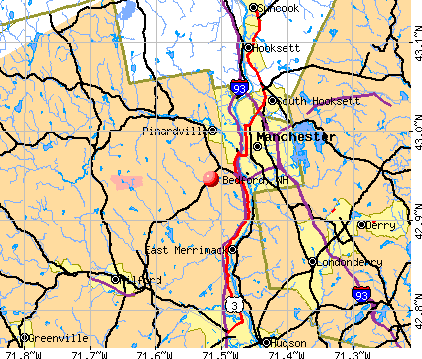
Bedford, New Hampshire

Bedford: Snowy day December 20, 2007
Bedford: Bedford Public Library
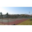
Bedford: Community Tennis Courts
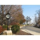
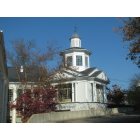
Bedford: Bedford Town Hall
- add
your
Submit your own pictures of this town and show them to the world
- OSM Map
- General Map
- Google Map
- MSN Map
Population change since 2000: +16.0%
 |
| Males: 10,367 | |
| Females: 10,836 |
| Median resident age: | 42.3 years |
| New Hampshire median age: | 43.9 years |
Zip codes: 03110.
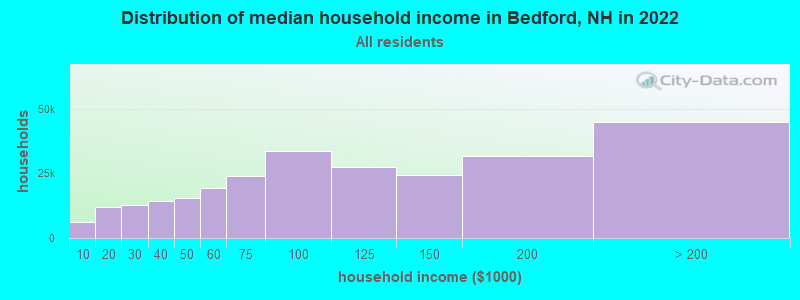
| Bedford: | $153,217 |
| NH: | $89,992 |
Estimated per capita income in 2022: $75,244 (it was $37,730 in 2000)
Bedford town income, earnings, and wages data
Estimated median house or condo value in 2022: $652,000 (it was $216,800 in 2000)
| Bedford: | $652,000 |
| NH: | $384,700 |
Mean prices in 2022: all housing units: $411,252; detached houses: $441,251; townhouses or other attached units: $283,002; in 2-unit structures: $347,377; in 3-to-4-unit structures: $666,663; in 5-or-more-unit structures: $275,798; mobile homes: $132,093
Detailed information about poverty and poor residents in Bedford, NH


- 19,78893.3%White alone
- 6122.9%Asian alone
- 3671.7%Hispanic
- 2701.3%Two or more races
- 1230.6%Black alone
- 200.09%American Indian alone
- 200.09%Other race alone
- 30.01%Native Hawaiian and Other
Pacific Islander alone
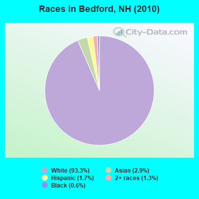
Races in Bedford detailed stats: ancestries, foreign born residents, place of birth
Type |
2009 |
2010 |
2011 |
2012 |
2013 |
2014 |
2015 |
2016 |
2017 |
2018 |
2019 |
2020 |
2021 |
2022 |
|---|---|---|---|---|---|---|---|---|---|---|---|---|---|---|
| Murders (per 100,000) | 0 (0.0) | 0 (0.0) | 0 (0.0) | 0 (0.0) | 0 (0.0) | 0 (0.0) | 2 (9.2) | 0 (0.0) | 0 (0.0) | 0 (0.0) | 0 (0.0) | 0 (0.0) | 2 (8.6) | 0 (0.0) |
| Rapes (per 100,000) | 3 (14.0) | 5 (23.6) | 3 (14.1) | 1 (4.7) | 5 (23.1) | 0 (0.0) | 4 (18.3) | 3 (13.4) | 3 (13.3) | 3 (13.3) | 5 (21.8) | 6 (26.3) | 0 (0.0) | 3 (12.6) |
| Robberies (per 100,000) | 6 (28.0) | 2 (9.4) | 4 (18.8) | 1 (4.7) | 4 (18.5) | 4 (18.4) | 5 (22.9) | 3 (13.4) | 1 (4.4) | 1 (4.4) | 3 (13.1) | 0 (0.0) | 1 (4.3) | 1 (4.2) |
| Assaults (per 100,000) | 11 (51.3) | 5 (23.6) | 12 (56.5) | 6 (28.2) | 4 (18.5) | 3 (13.8) | 10 (45.9) | 7 (31.2) | 9 (39.8) | 9 (39.8) | 4 (17.5) | 4 (17.6) | 1 (4.3) | 4 (16.8) |
| Burglaries (per 100,000) | 60 (279.9) | 32 (150.9) | 52 (244.9) | 43 (201.9) | 42 (194.0) | 35 (161.2) | 22 (100.9) | 17 (75.9) | 15 (66.3) | 2 (8.8) | 11 (48.1) | 5 (21.9) | 7 (30.3) | 6 (25.2) |
| Thefts (per 100,000) | 324 (1,511) | 290 (1,368) | 297 (1,399) | 348 (1,634) | 288 (1,331) | 288 (1,327) | 403 (1,848) | 322 (1,437) | 220 (972.5) | 186 (821.6) | 161 (703.5) | 118 (517.8) | 140 (605.1) | 111 (465.5) |
| Auto thefts (per 100,000) | 10 (46.6) | 6 (28.3) | 11 (51.8) | 7 (32.9) | 3 (13.9) | 8 (36.9) | 4 (18.3) | 9 (40.2) | 7 (30.9) | 5 (22.1) | 2 (8.7) | 9 (39.5) | 7 (30.3) | 6 (25.2) |
| Arson (per 100,000) | 3 (14.0) | 3 (14.1) | 5 (23.6) | 2 (9.4) | 2 (9.2) | 3 (13.8) | 0 (0.0) | 0 (0.0) | 2 (8.8) | 1 (4.4) | 1 (4.4) | 0 (0.0) | 0 (0.0) | 1 (4.2) |
| City-Data.com crime index | 113.6 | 93.9 | 105.5 | 92.9 | 95.6 | 75.6 | 131.5 | 87.0 | 65.9 | 55.1 | 57.1 | 50.0 | 48.2 | 37.1 |
The City-Data.com crime index weighs serious crimes and violent crimes more heavily. Higher means more crime, U.S. average is 246.1. It adjusts for the number of visitors and daily workers commuting into cities.
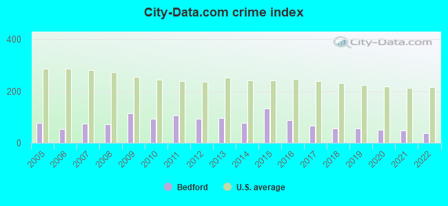
Crime rate in Bedford detailed stats: murders, rapes, robberies, assaults, burglaries, thefts, arson
Full-time law enforcement employees in 2021, including police officers: 48 (36 officers - 31 male; 5 female).
| Officers per 1,000 residents here: | 1.56 |
| New Hampshire average: | 2.14 |
 Recent articles from our blog. Our writers, many of them Ph.D. graduates or candidates, create easy-to-read articles on a wide variety of topics.

 | Bedford for Families (11 replies) |
| Hollis, NH, to retire? is New Hampshire conservative (85 replies) |
| Disconcerting old(ish) Hollis/Bedford school threads! (talk me off the ledge pls?) (32 replies) |
| Moving from CT to southern NH, looking at Windham or Bedford (20 replies) |
| Chickens allowed in Bedford? (8 replies) |
| Typical Summer Weather - Bedford, NH (18 replies) |
Latest news from Bedford, NH collected exclusively by city-data.com from local newspapers, TV, and radio stations
Ancestries: Irish (22.3%), English (14.8%), French Canadian (12.2%), German (11.3%), French (10.6%), Italian (9.1%).
Current Local Time: EST time zone
Incorporated in 1750
Elevation: 309 feet
Land area: 32.8 square miles.
Population density: 646 people per square mile (low).
611 residents are foreign born (1.2% Europe, 1.1% North America, 0.7% Asia).
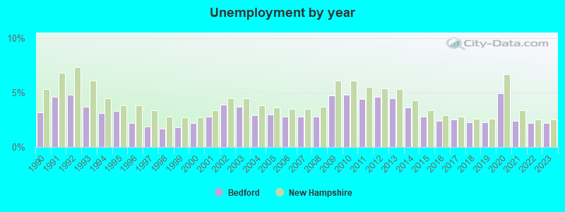
| This town: | 3.3% |
| New Hampshire: | 4.4% |
| Bedford town: | 1.6% ($3,558) |
| New Hampshire: | 2.3% ($2,946) |
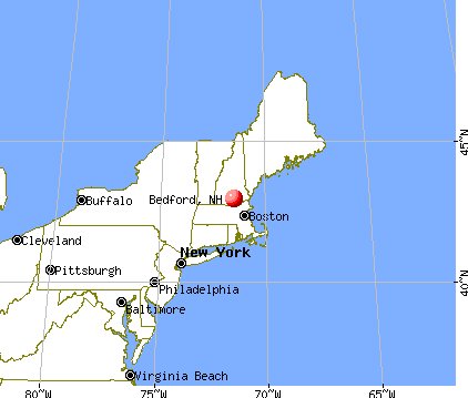
Nearest city with pop. 50,000+: Manchester, NH  (4.6 miles , pop. 107,006).
Nearest city with pop. 200,000+: Boston, MA (48.2 miles , pop. 589,141).
Nearest city with pop. 1,000,000+: Bronx, NY (188.9 miles , pop. 1,332,650).
Nearest cities:
), ), ), ), ), Latitude: 42.94 N, Longitude: 71.52 W
Area code: 603

Bedford, New Hampshire accommodation & food services, waste management - Economy and Business Data
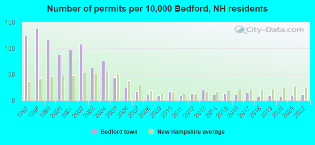
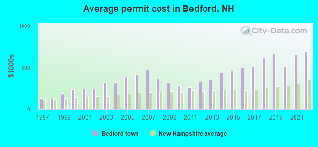
Single-family new house construction building permits:
- 2022: 22 buildings, average cost: $695,900
- 2021: 17 buildings, average cost: $659,100
- 2020: 13 buildings, average cost: $519,400
- 2019: 19 buildings, average cost: $665,000
- 2018: 13 buildings, average cost: $624,600
- 2017: 27 buildings, average cost: $510,600
- 2016: 20 buildings, average cost: $500,300
- 2015: 26 buildings, average cost: $464,500
- 2014: 21 buildings, average cost: $438,900
- 2013: 37 buildings, average cost: $355,400
- 2012: 25 buildings, average cost: $331,800
- 2011: 16 buildings, average cost: $265,000
- 2010: 33 buildings, average cost: $289,200
- 2009: 19 buildings, average cost: $322,900
- 2008: 21 buildings, average cost: $364,200
- 2007: 33 buildings, average cost: $476,800
- 2006: 47 buildings, average cost: $419,800
- 2005: 80 buildings, average cost: $385,700
- 2004: 139 buildings, average cost: $322,700
- 2003: 116 buildings, average cost: $322,600
- 2002: 197 buildings, average cost: $249,600
- 2001: 177 buildings, average cost: $250,100
- 2000: 161 buildings, average cost: $239,500
- 1999: 215 buildings, average cost: $196,300
- 1998: 254 buildings, average cost: $125,400
- 1997: 226 buildings, average cost: $127,900
| Here: | 2.2% |
| New Hampshire: | 2.5% |

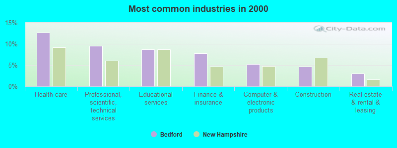
- Health care (12.7%)
- Professional, scientific, technical services (9.5%)
- Educational services (8.7%)
- Finance & insurance (7.8%)
- Computer & electronic products (5.2%)
- Construction (4.6%)
- Real estate & rental & leasing (3.1%)
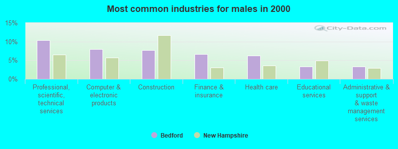
- Professional, scientific, technical services (10.4%)
- Computer & electronic products (8.0%)
- Construction (7.7%)
- Finance & insurance (6.7%)
- Health care (6.3%)
- Educational services (3.4%)
- Administrative & support & waste management services (3.3%)
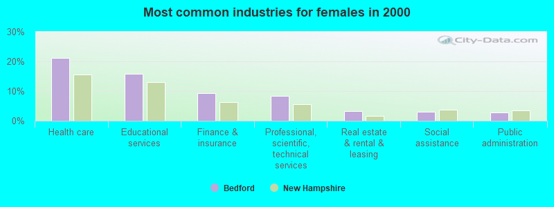
- Health care (21.1%)
- Educational services (15.7%)
- Finance & insurance (9.3%)
- Professional, scientific, technical services (8.4%)
- Real estate & rental & leasing (3.2%)
- Social assistance (3.0%)
- Public administration (2.8%)
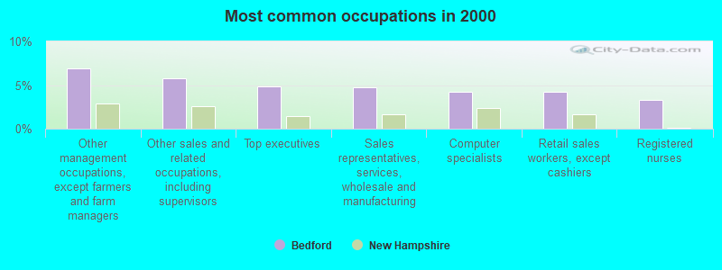
- Other management occupations, except farmers and farm managers (7.0%)
- Other sales and related occupations, including supervisors (5.7%)
- Top executives (4.9%)
- Sales representatives, services, wholesale and manufacturing (4.7%)
- Computer specialists (4.2%)
- Retail sales workers, except cashiers (4.2%)
- Registered nurses (3.3%)
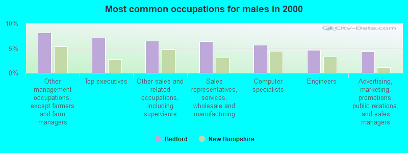
- Other management occupations, except farmers and farm managers (8.1%)
- Top executives (7.1%)
- Other sales and related occupations, including supervisors (6.5%)
- Sales representatives, services, wholesale and manufacturing (6.4%)
- Computer specialists (5.7%)
- Engineers (4.6%)
- Advertising, marketing, promotions, public relations, and sales managers (4.3%)
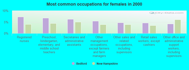
- Registered nurses (7.3%)
- Preschool, kindergarten, elementary, and middle school teachers (6.8%)
- Secretaries and administrative assistants (6.3%)
- Other management occupations, except farmers and farm managers (5.5%)
- Other sales and related occupations, including supervisors (4.7%)
- Retail sales workers, except cashiers (4.7%)
- Other office and administrative support workers, including supervisors (4.2%)
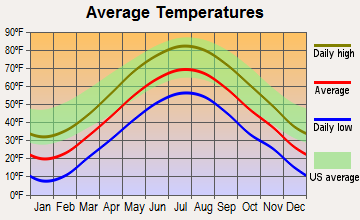
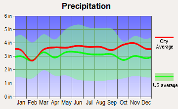
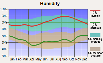
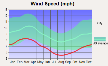
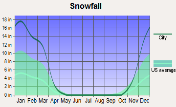
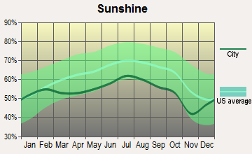
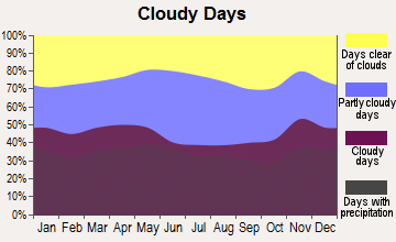
Average climate in Bedford, New Hampshire
Based on data reported by over 4,000 weather stations
(lower is better)
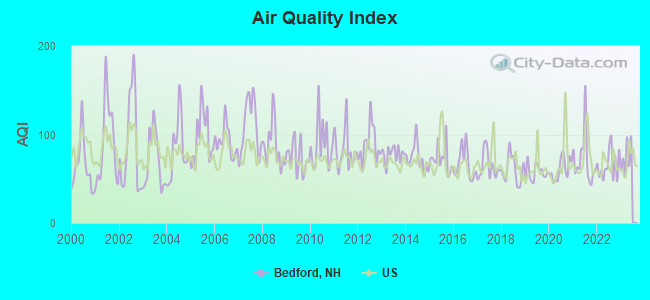
Air Quality Index (AQI) level in 2022 was 65.7. This is about average.
| City: | 65.7 |
| U.S.: | 72.6 |
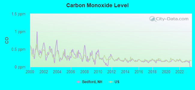
Carbon Monoxide (CO) [ppm] level in 2022 was 0.153. This is significantly better than average. Closest monitor was 4.5 miles away from the city center.
| City: | 0.153 |
| U.S.: | 0.251 |
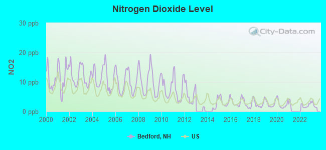
Nitrogen Dioxide (NO2) [ppb] level in 2022 was 2.05. This is significantly better than average. Closest monitor was 4.5 miles away from the city center.
| City: | 2.05 |
| U.S.: | 5.11 |
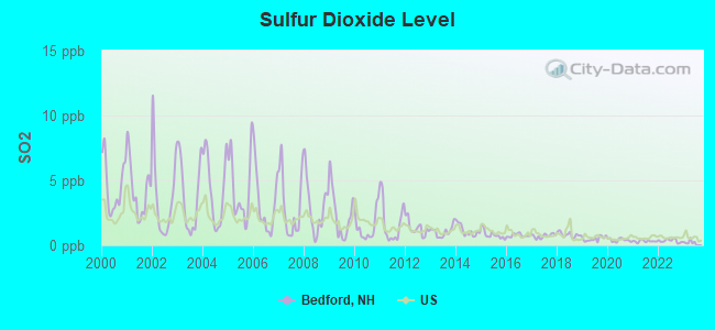
Sulfur Dioxide (SO2) [ppb] level in 2022 was 0.347. This is significantly better than average. Closest monitor was 4.4 miles away from the city center.
| City: | 0.347 |
| U.S.: | 1.515 |
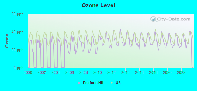
Ozone [ppb] level in 2022 was 30.4. This is about average. Closest monitor was 4.5 miles away from the city center.
| City: | 30.4 |
| U.S.: | 33.3 |
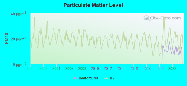
Particulate Matter (PM10) [µg/m3] level in 2022 was 10.6. This is significantly better than average. Closest monitor was 3.9 miles away from the city center.
| City: | 10.6 |
| U.S.: | 19.2 |
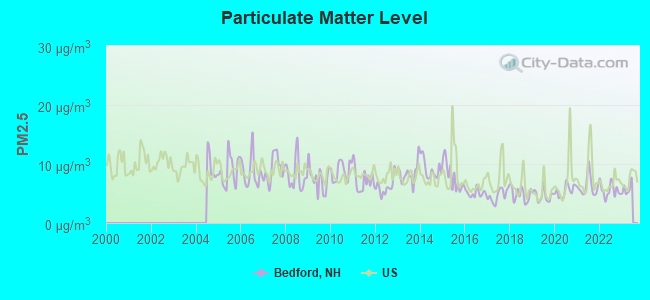
Particulate Matter (PM2.5) [µg/m3] level in 2022 was 5.56. This is significantly better than average. Closest monitor was 4.7 miles away from the city center.
| City: | 5.56 |
| U.S.: | 8.11 |
Tornado activity:
Bedford-area historical tornado activity is above New Hampshire state average. It is 35% smaller than the overall U.S. average.
On 6/9/1953, a category F4 (max. wind speeds 207-260 mph) tornado 44.4 miles away from the Bedford town center killed 90 people and injured 1228 people and caused between $50,000,000 and $500,000,000 in damages.
On 10/3/1970, a category F3 (max. wind speeds 158-206 mph) tornado 25.8 miles away from the town center killed one person and caused between $50,000 and $500,000 in damages.
Earthquake activity:
Bedford-area historical earthquake activity is significantly above New Hampshire state average. It is 71% smaller than the overall U.S. average.On 4/20/2002 at 10:50:47, a magnitude 5.3 (5.3 ML, Depth: 3.0 mi, Class: Moderate, Intensity: VI - VII) earthquake occurred 153.7 miles away from the city center
On 10/7/1983 at 10:18:46, a magnitude 5.3 (5.1 MB, 5.3 LG, 5.1 ML) earthquake occurred 158.0 miles away from Bedford center
On 1/19/1982 at 00:14:42, a magnitude 4.7 (4.5 MB, 4.7 MD, 4.5 LG, Class: Light, Intensity: IV - V) earthquake occurred 38.8 miles away from the city center
On 4/20/2002 at 10:50:47, a magnitude 5.2 (5.2 MB, 4.2 MS, 5.2 MW, 5.0 MW) earthquake occurred 153.2 miles away from the city center
On 10/16/2012 at 23:12:25, a magnitude 4.7 (4.7 ML, Depth: 10.0 mi) earthquake occurred 62.8 miles away from Bedford center
On 10/2/1994 at 11:27:22, a magnitude 3.7 (3.5 LG, 3.7 LG, Depth: 6.2 mi, Class: Light, Intensity: II - III) earthquake occurred 56.4 miles away from the city center
Magnitude types: regional Lg-wave magnitude (LG), body-wave magnitude (MB), duration magnitude (MD), local magnitude (ML), surface-wave magnitude (MS), moment magnitude (MW)
Natural disasters:
The number of natural disasters in Hillsborough County (27) is a lot greater than the US average (15).Major Disasters (Presidential) Declared: 17
Emergencies Declared: 10
Causes of natural disasters: Storms: 13, Floods: 11, Winter Storms: 5, Snowstorms: 4, Hurricanes: 3, Snows: 3, Blizzard: 1, Ice Storm: 1, Snowfall: 1, Wind: 1 (Note: some incidents may be assigned to more than one category).

Hospitals and medical centers in Bedford:
Heliports located in Bedford:
See details about Heliports located in Bedford, NHCollege/University in Bedford:
Colleges/universities with over 2000 students nearest to Bedford:
- Saint Anselm College (about 4 miles; Manchester, NH; Full-time enrollment: 2,059)
- Mount Washington College (about 4 miles; Manchester, NH; FT enrollment: 2,187)
- Southern New Hampshire University (about 8 miles; Manchester, NH; FT enrollment: 16,552)
- NHTI-Concord's Community College (about 20 miles; Concord, NH; FT enrollment: 2,865)
- University of Massachusetts-Lowell (about 23 miles; Lowell, MA; FT enrollment: 12,341)
- Northern Essex Community College (about 27 miles; Haverhill, MA; FT enrollment: 4,737)
- Merrimack College (about 28 miles; North Andover, MA; FT enrollment: 2,734)
Public high school in Bedford:
- BEDFORD HIGH SCHOOL (Location: 47B NASHUA RD., Grades: 9-12)
Public elementary/middle schools in Bedford:
- RIDDLE BROOK SCHOOL (Students: 740, Location: 230 NEW BOSTON RD., Grades: KG-4)
- PETER WOODBURY SCHOOL (Students: 682, Location: 180 COUNTY RD., Grades: KG-4)
- MCKELVIE INTERMEDIATE SCHOOL (Location: 108 LIBERTY HILL RD., Grades: 5-6)
- MEMORIAL SCHOOL (Location: 55 OLD BEDFORD RD., Grades: PK-4)
- ROSS A. LURGIO MIDDLE SCHOOL (Location: 47A NASHUA RD., Grades: 7-8)
Private elementary/middle school in Bedford:
Library in Bedford:
User-submitted facts and corrections:
- New Hampshire College is now Southern New Hampshire University (2001).
Points of interest:
Notable locations in Bedford: Camp Kettleford (A), Camp Foster (B), Camp Allen (C), Manchester Country Club (D), Bedford Fire Department (E), Bedford Town Hall (F), Bedford Public Library (G). Display/hide their locations on the map
Shopping Center: The Bedford Mall Shopping Center (1). Display/hide its location on the map
Churches in Bedford include: Bedford Community Church (A), Bedford Presbyterian Church (B). Display/hide their locations on the map
Cemeteries: Beals Cemetery (1), Center Cemetery (2), New Saint Josephs Cemetery (3). Display/hide their locations on the map
Lakes and reservoirs: McMahons Pond (A), Sebbins Pond (B), Woodbury Estate Pond (C). Display/hide their locations on the map
Streams, rivers, and creeks: Sebbins Brook (A), Pulpit Brook (B), Pointer Club Brook (C), Bowman Brook (D). Display/hide their locations on the map
Tourist attraction: Marconi Foundation & Museum (18 North Amherst Rd) (1). Display/hide its approximate location on the map
Hotels: Quality Inn Manchester Airport (121 South River Road) (1), Wayfarer Inn (121 South River Road) (2), Hampton Inn & Suites (8 Hawthorne Drive) (3), Hill-Brook Motel (250 Route 101) (4), Four Seasons Air (13 Silver Spring Drive) (5), The Wayfarer Inn (121 South River Road) (6). Display/hide their approximate locations on the map
Birthplace of: Sarah Silverman - US Comedian, Carrie Jones - Novelist, L. Scott Rice - Air Force general, Zachariah Chandler, Josh Meyers - Comedian, Laura Silverman - Actor, Chris Lutz - College basketball player (Purdue Boilermakers), David Atwood - Politician, Joseph Emerson Worcester - (1784 - 1865), lexicographer.
Drinking water stations with addresses in Bedford and their reported violations in the past:
CENTURY VILLAGE CONDOS (Population served: 875, Groundwater):Past health violations:Z1 EXPRESS CHICHESTER (Population served: 360, Groundwater):Past monitoring violations:
- MCL, Monthly (TCR) - In SEP-2013, Contaminant: Coliform. Follow-up actions: St Public Notif requested (SEP-12-2013), St Violation/Reminder Notice (SEP-12-2013), St Public Notif received (SEP-17-2013), St Compliance achieved (APR-10-2014)
- MCL, Monthly (TCR) - In APR-2012, Contaminant: Coliform. Follow-up actions: St Public Notif requested (APR-23-2012), St Violation/Reminder Notice (APR-23-2012), St Public Notif received (MAY-23-2012), St Compliance achieved (OCT-29-2012)
- MCL, Monthly (TCR) - In OCT-2007, Contaminant: Coliform. Follow-up actions: St Public Notif requested (OCT-17-2007), St Violation/Reminder Notice (OCT-17-2007), St Public Notif received (NOV-08-2007), St Compliance achieved (MAY-07-2008)
- Lead Consumer Notice - In OCT-01-2012, Contaminant: Lead and Copper Rule. Follow-up actions: St Violation/Reminder Notice (NOV-30-2012), St Compliance achieved (DEC-07-2012)
Past monitoring violations:FARNSWORTH CAMP (Serves VT, Population served: 300, Groundwater):
- One routine major monitoring violation
Past health violations:SHORTYS GRILL (Population served: 200, Groundwater):Past monitoring violations:
- MCL, Monthly (TCR) - In AUG-2007, Contaminant: Coliform. Follow-up actions: St Tech Assistance Visit (AUG-29-2007), St Formal NOV issued (AUG-29-2007), St Boil Water Order (AUG-29-2007), St Public Notif requested (AUG-29-2007), St Public Notif received (SEP-05-2007), St Compliance achieved (NOV-09-2011)
- MCL, Monthly (TCR) - In JUL-2007, Contaminant: Coliform. Follow-up actions: St Tech Assistance Visit (JUL-19-2007), St Formal NOV issued (JUL-19-2007), St Boil Water Order (JUL-19-2007), St Public Notif requested (JUL-19-2007), St Public Notif received (SEP-05-2007), St Compliance achieved (NOV-09-2011)
- 3 routine major monitoring violations
- One regular monitoring violation
Past health violations:Z1 EXPRESS (Population served: 200, Groundwater):Past monitoring violations:
- MCL, Monthly (TCR) - Between OCT-2013 and DEC-2013, Contaminant: Coliform. Follow-up actions: St Public Notif requested (OCT-21-2013), St Violation/Reminder Notice (OCT-21-2013), St Public Notif received (OCT-25-2013), St Compliance achieved (APR-10-2014)
- MCL, Average - Between JAN-2007 and MAR-2007, Contaminant: Nitrate. Follow-up actions: St Compliance achieved (OCT-17-2008)
- Monitoring, Repeat Major (TCR) - Between OCT-2013 and DEC-2013, Contaminant: Coliform (TCR). Follow-up actions: St Public Notif requested (NOV-27-2013), St Violation/Reminder Notice (NOV-27-2013), St Compliance achieved (DEC-03-2013), St Public Notif received (DEC-18-2013)
- One routine major monitoring violation
- One regular monitoring violation
Past health violations:PACKER MEADOWS (Population served: 115, Groundwater):Past monitoring violations:
- MCL, Monthly (TCR) - Between OCT-2007 and DEC-2007, Contaminant: Coliform. Follow-up actions: St Public Notif requested (OCT-31-2007), St Violation/Reminder Notice (OCT-31-2007), St Public Notif received (NOV-08-2007), St Formal NOV issued (JAN-31-2008), St Compliance achieved (SEP-19-2008)
- 2 routine major monitoring violations
Past health violations:CASTLETON MEADOWS (Address: 5A EAST POINT DR , Serves VT, Population served: 107, Purch groundwater):
- MCL, Average - Between JAN-2014 and MAR-2014, Contaminant: Arsenic. Follow-up actions: St Public Notif requested (JAN-24-2014), St Violation/Reminder Notice (JAN-24-2014), St Public Notif received (JAN-29-2014)
- MCL, Average - Between OCT-2007 and DEC-2007, Contaminant: Arsenic. Follow-up actions: St Public Notif requested (DEC-28-2007), St Violation/Reminder Notice (DEC-28-2007), St Public Notif received (JAN-08-2008), St Compliance achieved (JUN-19-2008)
- MCL, Average - Between JUL-2007 and SEP-2007, Contaminant: Arsenic. Follow-up actions: St Public Notif requested (SEP-07-2007), St Violation/Reminder Notice (SEP-07-2007), St Public Notif received (SEP-14-2007), St Compliance achieved (JUN-19-2008)
- MCL, Average - Between APR-2007 and JUN-2007, Contaminant: Arsenic. Follow-up actions: St Public Notif requested (JUN-27-2007), St Violation/Reminder Notice (JUN-27-2007), St Public Notif received (JUL-03-2007), St Compliance achieved (JUN-19-2008)
- MCL, Average - Between JAN-2007 and MAR-2007, Contaminant: Arsenic. Follow-up actions: St Public Notif requested (APR-19-2007), St Violation/Reminder Notice (APR-19-2007), St Public Notif received (MAY-14-2007), St Compliance achieved (JUN-19-2008)
Past health violations:BALMORAL CONDOS (Population served: 105, Groundwater):Past monitoring violations:
- MCL, Monthly (TCR) - In MAY-2012, Contaminant: Coliform. Follow-up actions: St Tech Assistance Visit (MAY-22-2012), St Formal NOV issued (MAY-22-2012), St Boil Water Order (MAY-22-2012), St Public Notif requested (MAY-22-2012), St Public Notif received (MAY-29-2012), St Compliance achieved (JUN-07-2012)
- One routine major monitoring violation
Past health violations:Past monitoring violations:
- MCL, Monthly (TCR) - In JUN-2011, Contaminant: Coliform. Follow-up actions: St Public Notif requested (JUN-20-2011), St Violation/Reminder Notice (JUN-20-2011), St Public Notif received (JUN-27-2011), St Compliance achieved (FEB-24-2012)
- MCL, Average - Between JAN-2010 and MAR-2010, Contaminant: Thallium, Total. Follow-up actions: St Public Notif requested (MAR-19-2010), St Violation/Reminder Notice (MAR-19-2010), St Public Notif received (MAR-24-2010), St Compliance achieved (AUG-02-2010)
- MCL, Average - Between OCT-2009 and DEC-2009, Contaminant: Thallium, Total. Follow-up actions: St Public Notif requested (MAR-19-2010), St Violation/Reminder Notice (MAR-19-2010), St Public Notif received (MAR-24-2010), St Compliance achieved (AUG-02-2010)
- MCL, Average - Between JUL-2009 and SEP-2009, Contaminant: Thallium, Total. Follow-up actions: St Public Notif requested (NOV-30-2009), St Violation/Reminder Notice (NOV-30-2009), St Public Notif received (MAR-15-2010), St Compliance achieved (AUG-02-2010)
- MCL, Average - Between APR-2009 and JUN-2009, Contaminant: Thallium, Total. Follow-up actions: St Violation/Reminder Notice (JUL-23-2009), St Public Notif requested (JUL-23-2009), St Public Notif received (AUG-24-2009), St Compliance achieved (AUG-02-2010)
- MCL, Monthly (TCR) - In AUG-2007, Contaminant: Coliform. Follow-up actions: St Public Notif requested (AUG-21-2007), St Violation/Reminder Notice (AUG-21-2007), St Public Notif received (AUG-30-2007), St Formal NOV issued (AUG-31-2007), St Compliance achieved (APR-08-2008)
- MCL, Monthly (TCR) - In JUL-2006, Contaminant: Coliform. Follow-up actions: St Public Notif requested (JUL-24-2006), St Violation/Reminder Notice (JUL-24-2006), St Public Notif received (JUL-31-2006), St Compliance achieved (JAN-31-2007)
- Lead Consumer Notice - In JUL-01-2012, Contaminant: Lead and Copper Rule. Follow-up actions: St Violation/Reminder Notice (JUL-10-2012), St Formal NOV issued (SEP-10-2012), St Compliance achieved (SEP-20-2012)
- Follow-up Or Routine LCR Tap M/R - In APR-01-2009, Contaminant: Lead and Copper Rule. Follow-up actions: St Public Notif requested (MAY-01-2009), St Violation/Reminder Notice (MAY-01-2009), St Compliance achieved (MAY-11-2009), St Public Notif received (MAY-14-2009)
Drinking water stations with addresses in Bedford that have no violations reported:
- RILEY FIELD COMPLEX (Population served: 600, Primary Water Source Type: Groundwater)
- KINGSTON PINES ELDERLY HOUSING (Population served: 125, Primary Water Source Type: Groundwater)
- TWIN HILLS (Serves VT, Population served: 25, Primary Water Source Type: Groundwater)
| This town: | 2.8 people |
| New Hampshire: | 2.5 people |
| This town: | 79.2% |
| Whole state: | 66.3% |
| This town: | 4.7% |
| Whole state: | 8.3% |
Likely homosexual households (counted as self-reported same-sex unmarried-partner households)
- Lesbian couples: 0.4% of all households
- Gay men: 0.4% of all households
| This town: | 2.2% |
| Whole state: | 6.5% |
| This town: | 0.9% |
| Whole state: | 2.8% |
375 people in nursing homes in 2000
70 people in other noninstitutional group quarters in 2000
Banks with branches in Bedford (2011 data):
- RBS Citizens, National Association: Bedford Branch, Bedford S&S Nh Branch, Bedford Drive-Up Branch. Info updated 2007/09/19: Bank assets: $106,940.6 mil, Deposits: $75,690.2 mil, headquarters in Providence, RI, positive income, 1135 total offices, Holding Company: Uk Financial Investments Limited
- Centrix Bank & Trust: at 1 Atwood Lane, branch established on 1999/06/07; Messenger Branch at 1 Atwood Lane, branch established on 2007/04/16. Info updated 2008/08/12: Bank assets: $757.6 mil, Deposits: $606.8 mil, local headquarters, positive income, Commercial Lending Specialization, 7 total offices
- TD Bank, National Association: Bedford Branch at 184 Rt 101, branch established on 1979/11/19; 141 South River Road Branch at 141 South River Road, branch established on 1990/05/30. Info updated 2010/10/04: Bank assets: $188,912.6 mil, Deposits: $153,149.8 mil, headquarters in Wilmington, DE, positive income, 1314 total offices, Holding Company: Toronto-Dominion Bank, The
- Bank of New England: Bedford Branch at 177 South River Road, branch established on 1998/07/20. Info updated 2007/06/12: Bank assets: $470.7 mil, Deposits: $405.4 mil, headquarters in Salem, NH, positive income, Commercial Lending Specialization, 9 total offices
- Bank of America, National Association: Bedford Branch at 46 South River Road, branch established on 1992/09/21. Info updated 2009/11/18: Bank assets: $1,451,969.3 mil, Deposits: $1,077,176.8 mil, headquarters in Charlotte, NC, positive income, 5782 total offices, Holding Company: Bank Of America Corporation
- Laconia Savings Bank: Bedford Branch at 265 Wallace Road, branch established on 2005/01/26. Info updated 2009/02/12: Bank assets: $1,107.3 mil, Deposits: $876.1 mil, headquarters in Laconia, NH, positive income, Commercial Lending Specialization, 23 total offices, Holding Company: Lsb Financial
For population 15 years and over in Bedford:
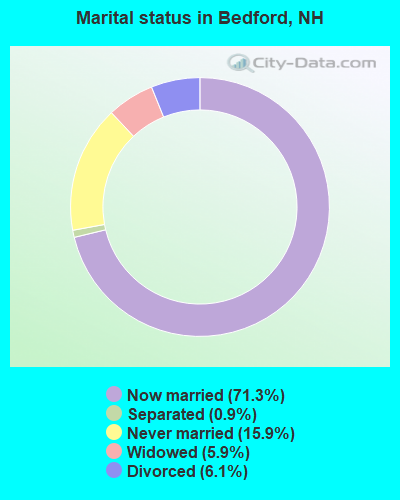
- Never married: 15.9%
- Now married: 71.3%
- Separated: 0.9%
- Widowed: 5.9%
- Divorced: 6.1%
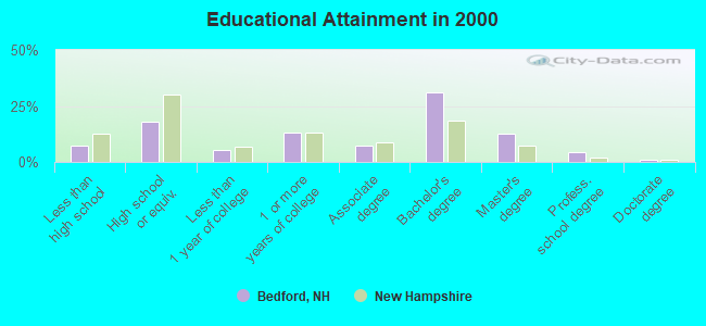
For population 25 years and over in Bedford:
- High school or higher: 92.6%
- Bachelor's degree or higher: 49.3%
- Graduate or professional degree: 18.1%
- Unemployed: 2.7%
- Mean travel time to work (commute): 27.2 minutes

| Here: | 10.7 |
| New Hampshire average: | 10.9 |


Graphs represent county-level data. Detailed 2008 Election Results
Religion statistics for Bedford, NH (based on Hillsborough County data)


| Religion | Adherents | Congregations |
|---|---|---|
| Catholic | 124,993 | 40 |
| Evangelical Protestant | 20,588 | 103 |
| Mainline Protestant | 17,794 | 60 |
| Other | 7,365 | 35 |
| Orthodox | 2,990 | 7 |
| Black Protestant | - | 1 |
| None | 226,991 | - |
Food Environment Statistics:
| Hillsborough County: | 1.82 / 10,000 pop. |
| New Hampshire: | 2.14 / 10,000 pop. |
| This county: | 0.12 / 10,000 pop. |
| State: | 0.15 / 10,000 pop. |
| Hillsborough County: | 1.65 / 10,000 pop. |
| New Hampshire: | 1.78 / 10,000 pop. |
| Hillsborough County: | 2.67 / 10,000 pop. |
| State: | 4.02 / 10,000 pop. |
| Here: | 8.23 / 10,000 pop. |
| State: | 9.70 / 10,000 pop. |
| This county: | 6.9% |
| New Hampshire: | 7.6% |
| Hillsborough County: | 24.5% |
| New Hampshire: | 24.4% |
| This county: | 15.1% |
| State: | 15.9% |
6.73% of this county's 2021 resident taxpayers lived in other counties in 2020 ($92,767 average adjusted gross income)
| Here: | 6.73% |
| New Hampshire average: | 7.66% |
0.01% of residents moved from foreign countries ($183 average AGI)
Hillsborough County: 0.01% New Hampshire average: 0.01%
Top counties from which taxpayers relocated into this county between 2020 and 2021:
| from Middlesex County, MA | |
| from Rockingham County, NH | |
| from Merrimack County, NH |
6.49% of this county's 2020 resident taxpayers moved to other counties in 2021 ($81,100 average adjusted gross income)
| Here: | 6.49% |
| New Hampshire average: | 6.80% |
0.02% of residents moved to foreign countries ($105 average AGI)
Hillsborough County: 0.02% New Hampshire average: 0.01%
Top counties to which taxpayers relocated from this county between 2020 and 2021:
| to Rockingham County, NH | |
| to Merrimack County, NH | |
| to Middlesex County, MA |
| Businesses in Bedford, NH | ||||
| Name | Count | Name | Count | |
|---|---|---|---|---|
| CVS | 1 | Outback Steakhouse | 1 | |
| Circle K | 2 | Panera Bread | 1 | |
| Dunkin Donuts | 4 | RadioShack | 1 | |
| FedEx | 6 | Rite Aid | 1 | |
| GNC | 1 | Staples | 1 | |
| GameStop | 1 | Starbucks | 1 | |
| Hilton | 1 | Subway | 1 | |
| IHOP | 1 | T-Mobile | 2 | |
| Jones New York | 1 | Talbots | 2 | |
| Lowe's | 1 | Target | 1 | |
| Macy's | 1 | The Room Place | 1 | |
| Marshalls | 1 | U-Haul | 2 | |
| MasterBrand Cabinets | 5 | UPS | 10 | |
| Motherhood Maternity | 1 | Walgreens | 1 | |
| Nike | 1 | Walmart | 1 | |
| Outback | 1 | |||
Strongest AM radio stations in Bedford:
- WGIR (610 AM; 5 kW; MANCHESTER, NH; Owner: CAPSTAR TX LIMITED PARTNERSHIP)
- WFEA (1370 AM; 5 kW; MANCHESTER, NH; Owner: SAGA COMMUNICATIONS OF NEW ENGLAND, LLC)
- WKBR (1250 AM; 5 kW; MANCHESTER, NH; Owner: DEVON BROADCASTING COMPANY, INC.)
- WRKO (680 AM; 50 kW; BOSTON, MA; Owner: ENTERCOM BOSTON LICENSE, LLC)
- WDER (1320 AM; 10 kW; DERRY, NH; Owner: BLOUNT COMMUNICATIONS, INC. OF NH)
- WEEI (850 AM; 50 kW; BOSTON, MA; Owner: ENTERCOM BOSTON LICENSE, LLC)
- WCRN (830 AM; 50 kW; WORCESTER, MA; Owner: CARTER BROADCASTING CORPORATION)
- WKOX (1200 AM; 50 kW; FRAMINGHAM, MA; Owner: CAPSTAR TX LIMITED PARTNERSHIP)
- WWZN (1510 AM; 50 kW; BOSTON, MA; Owner: ROSE CITY RADIO CORPORATION)
- WBIX (1060 AM; 40 kW; NATICK, MA; Owner: LANGER BROADCASTING CORPORATION)
- WSMN (1590 AM; 5 kW; NASHUA, NH; Owner: 1590 BROADCASTING CORP.)
- WBZ (1030 AM; 50 kW; BOSTON, MA; Owner: INFINITY BROADCASTING OPERATIONS, INC.)
- WCEC (1110 AM; daytime; 5 kW; SALEM, NH; Owner: COSTA-EAGLE RADIO VENTURES LTD PARTNERSHIP)
Strongest FM radio stations in Bedford:
- WGIR-FM (101.1 FM; MANCHESTER, NH; Owner: CAPSTAR TX LIMITED PARTNERSHIP)
- WLMW (90.7 FM; MANCHESTER, NH; Owner: KNOWLEDGE FOR LIFE)
- WQLL (96.5 FM; BEDFORD, NH; Owner: SAGA COMMUNICATIONS OF NEW ENGLAND, LLC)
- WZID (95.7 FM; MANCHESTER, NH; Owner: SAGA COMMUNICATIONS OF NEW ENGLAND, LLC)
- WFEX (92.1 FM; PETERBOROUGH, NH; Owner: FNX BROADCASTING OF NEW HAMPSHIRE LLC)
- W250AB (97.9 FM; MANCHESTER, NH; Owner: CITADEL BROADCASTING COMPANY)
- WHOB (106.3 FM; NASHUA, NH; Owner: TELE-MEDIA COMPANY OF NEW HAMPSHIRE, L.L.C.)
- WHDQ (106.1 FM; CLAREMONT, NH; Owner: GREAT NORTHERN RADIO, L.L.C.)
- WNNH (99.1 FM; HENNIKER, NH; Owner: TELE-MEDIA COMPANY OF NEW HAMPSHIRE, L.L.C.)
- W282AF (104.3 FM; CONCORD, NH; Owner: CONCORD BIBLE FELLOWSHIP)
- WTPL (107.7 FM; HILLSBORO, NH; Owner: CONCORD BROADCASTING, L.L.C.)
- WNHI (93.3 FM; BELMONT, NH; Owner: CONCORD BROADCASTING, L.L.C.)
- WXRV (92.5 FM; HAVERHILL, MA; Owner: BEANPOT BROADCASTING CORP.)
- WVPR (89.5 FM; WINDSOR, VT; Owner: VERMONT PUBLIC RADIO)
- WSCY (106.9 FM; MOULTONBOROUGH, NH; Owner: NORTHEAST COMMUNICATIONS CORPORATION)
- WKLB-FM (99.5 FM; LOWELL, MA; Owner: GREATER BOSTON RADIO, INC.)
- W227AM (93.3 FM; ANDOVER, MA; Owner: GREATER BOSTON RADIO, INC.)
- WEVO (89.1 FM; CONCORD, NH; Owner: NEW HAMPSHIRE PUBLIC RADIO)
- WJYY (105.5 FM; CONCORD, NH; Owner: CONCORD BROADCASTING, L.L.C.)
- WLKZ (104.9 FM; WOLFEBORO, NH; Owner: TELE-MEDIA COMPANY OF NEW HAMPSHIRE, L.L.C.)
TV broadcast stations around Bedford:
- WMUR-TV (Channel 9; MANCHESTER, NH; Owner: HEARST-ARGYLE PROPERTIES, INC.)
- WNEU (Channel 60; MERRIMACK, NH; Owner: NBC SUBSIDIARY (NH), INC.)
- W29AT (Channel 29; MANCHESTER, NH; Owner: CENTER BROADCASTING CORP. OF NEW HAMPSHIRE)
- WFXZ-CA (Channel 24; BOSTON, MA; Owner: BOSTON BROADCASTING CORP.)
- WNDS (Channel 50; DERRY, NH; Owner: CTV OF DERRY, INC)
- WCVB-TV (Channel 5; BOSTON, MA; Owner: WCVB HEARST-ARGYLE TV, INC.)
- WGBH-TV (Channel 2; BOSTON, MA; Owner: WGBH EDUCATIONAL FOUNDATION)
- WUTF (Channel 66; MARLBOROUGH, MA; Owner: TELEFUTURA BOSTON LLC)
- WMEA-TV (Channel 26; BIDDEFORD, ME; Owner: MAINE PUBLIC BROADCASTING CORP.)
- WENH-TV (Channel 11; DURHAM, NH; Owner: UNIVERSITY OF NEW HAMPSHIRE)
- WUNI (Channel 27; WORCESTER, MA; Owner: ENTRAVISION HOLDINGS, LLC)
- WMFP (Channel 62; LAWRENCE, MA; Owner: WSAH LICENSE, INC.)
- WBZ-TV (Channel 4; BOSTON, MA; Owner: VIACOM INC.)
- WGBX-TV (Channel 44; BOSTON, MA; Owner: WGBH EDUCATIONAL FOUNDATION)
- WSBK-TV (Channel 38; BOSTON, MA; Owner: VIACOM INC.)
- WLVI-TV (Channel 56; CAMBRIDGE, MA; Owner: WLVI, INC.)
- WHDN-LP (Channel 26; BOSTON, MA; Owner: GUENTER MARKSTEINER)
- WFXT (Channel 25; BOSTON, MA; Owner: FOX TELEVISION STATIONS INC.)
- WPXG (Channel 21; CONCORD, NH; Owner: PAXSON BOSTON-68 LICENSE, INC.)
- WYCN-LP (Channel 13; NASHUA, NH; Owner: CENTER BROADCASTING CORP. OF NEW HAMPSHIRE)
- W33AK (Channel 33; NASHUA, NH; Owner: CENTER B/CING CORPORATION OF NEW HAMPSHIRE)
- National Bridge Inventory (NBI) Statistics
- 37Number of bridges
- 551ft / 168mTotal length
- $72,266,000Total costs
- 640,535Total average daily traffic
- 43,730Total average daily truck traffic
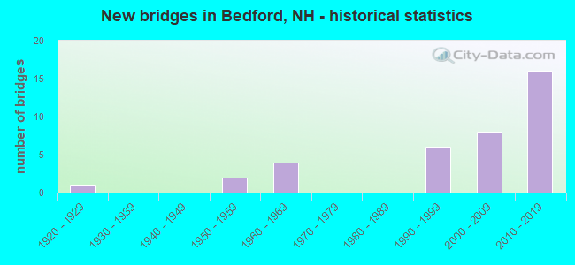
- New bridges - historical statistics
- 11920-1929
- 21950-1959
- 41960-1969
- 61990-1999
- 82000-2009
- 162010-2019
FCC Registered Antenna Towers: 48 (See the full list of FCC Registered Antenna Towers)
FCC Registered Commercial Land Mobile Towers: 1 (See the full list of FCC Registered Commercial Land Mobile Towers in Bedford, NH)
FCC Registered Private Land Mobile Towers: 1 (See the full list of FCC Registered Private Land Mobile Towers)
FCC Registered Broadcast Land Mobile Towers: 9 (See the full list of FCC Registered Broadcast Land Mobile Towers)
FCC Registered Microwave Towers: 8 (See the full list of FCC Registered Microwave Towers in this town)
FCC Registered Amateur Radio Licenses: 290 (See the full list of FCC Registered Amateur Radio Licenses in Bedford)
FAA Registered Aircraft: 31 (See the full list of FAA Registered Aircraft in Bedford)
2003 - 2018 National Fire Incident Reporting System (NFIRS) incidents
- Fire incident types reported to NFIRS in Bedford, NH
- 46547.6%Structure Fires
- 36637.5%Outside Fires
- 12412.7%Mobile Property/Vehicle Fires
- 222.3%Other
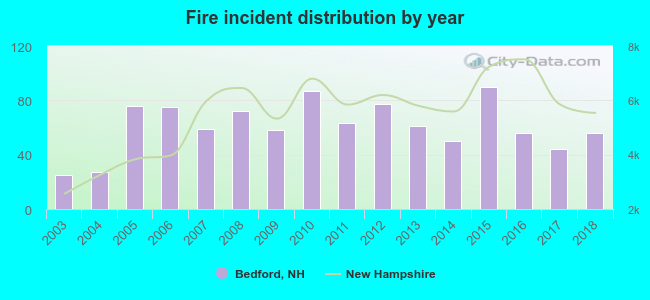 According to the data from the years 2003 - 2018 the average number of fires per year is 61. The highest number of reported fire incidents - 90 took place in 2015, and the least - 25 in 2003. The data has a growing trend.
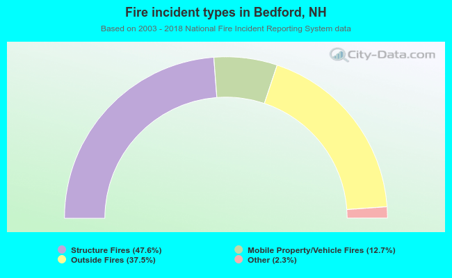 When looking into fire subcategories, the most reports belonged to: Structure Fires (47.6%), and Outside Fires (37.5%).
Fire-safe hotels and motels in Bedford, New Hampshire:
- Quality Inn Wayfarer Convention Center, 121 S River Rd, Bedford, New Hampshire 03110 , Phone: (603) 622-3766, Fax: (603) 625-1126
- Hampton Inn And Suites, 8 Hawthorne Dr, Bedford, New Hampshire 03110 , Phone: (603) 623-2040, Fax: (603) 623-2041
- Country Inn & Suites By Carlson, 250 S River Rd, Bedford, New Hampshire 03110 , Phone: (603) 666-4600, Fax: (603) 666-3200
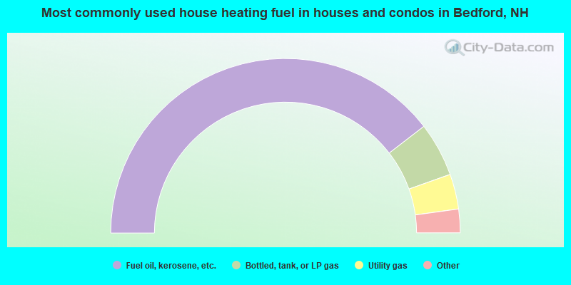
- 79.1%Fuel oil, kerosene, etc.
- 10.0%Bottled, tank, or LP gas
- 6.5%Utility gas
- 3.5%Electricity
- 1.0%Wood
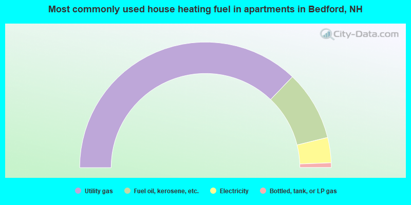
- 74.2%Utility gas
- 18.0%Fuel oil, kerosene, etc.
- 6.5%Electricity
- 1.2%Bottled, tank, or LP gas
Bedford compared to New Hampshire state average:
- Median household income above state average.
- Median house value above state average.
- Unemployed percentage significantly below state average.
- Black race population percentage below state average.
- Hispanic race population percentage below state average.
- Foreign-born population percentage below state average.
- Renting percentage below state average.
- Length of stay since moving in significantly above state average.
- Number of rooms per house significantly below state average.
- House age significantly below state average.
- Institutionalized population percentage above state average.
- Percentage of population with a bachelor's degree or higher above state average.
Bedford on our top lists:
- #15 on the list of "Top 101 cities with largest percentage of males in occupations: air transportation workers (population 5,000+)"
- #19 on the list of "Top 101 cities with largest percentage of males in occupations: advertising, marketing, promotions, public relations, and sales managers (population 5,000+)"
- #31 on the list of "Top 101 cities with largest percentage of males in occupations: operations specialties managers except financial managers (population 5,000+)"
- #31 on the list of "Top 101 cities with largest percentage of females in industries: radio, tv, and computer stores (population 5,000+)"
- #35 on the list of "Top 101 cities with largest percentage of males in occupations: social scientists and related workers (population 5,000+)"
- #44 on the list of "Top 101 cities with largest percentage of males in industries: professional and commercial equipment and supplies merchant wholesalers (population 5,000+)"
- #49 on the list of "Top 101 cities with largest percentage of females in occupations: registered nurses (population 5,000+)"
- #50 on the list of "Top 101 cities with largest percentage of males in occupations: top executives (population 5,000+)"
- #58 on the list of "Top 101 cities with largest percentage of males in industries: air transportation (population 5,000+)"
- #60 on the list of "Top 101 cities with largest percentage of males in industries: computer and electronic products (population 5,000+)"
- #64 on the list of "Top 101 cities with largest percentage of males in industries: radio, tv, and computer stores (population 5,000+)"
- #67 on the list of "Top 101 cities with largest percentage of females in industries: vending machine operators (population 5,000+)"
- #91 on the list of "Top 101 cities with largest percentage of females in industries: miscellaneous nondurable goods merchant wholesalers (population 5,000+)"
- #100 on the list of "Top 101 cities with largest percentage of males in industries: beverage and tobacco products (population 5,000+)"
- #89 (03110) on the list of "Top 101 zip codes with the largest percentage of French Canadian first ancestries (pop 5,000+)"
- #6 on the list of "Top 101 counties with the lowest Particulate Matter (PM10) Annual air pollution readings in 2012 (µg/m3)"
- #12 on the list of "Top 101 counties with the lowest Particulate Matter (PM2.5) Annual air pollution readings in 2012 (µg/m3)"
- #15 on the list of "Top 101 counties with the lowest number of infant deaths per 1000 residents 2007-2013 (pop. 50,000+)"
- #24 on the list of "Top 101 counties with the largest decrease in the number of infant deaths per 1000 residents 2000-2006 to 2007-2013 (pop. 50,000+)"
- #44 on the list of "Top 101 counties with the lowest Nitrogen Dioxide air pollution readings in 2012 (ppm)"

|
|
Total of 1003 patent applications in 2008-2024.