Bridge Statistics for Belcher, Louisiana (LA)
Condition, Traffic, Stress, Structural Evaluation, Project Costs
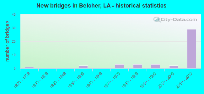
- New bridges - historical statistics
- 11920-1929
- 21950-1959
- 31970-1979
- 31980-1989
- 31990-1999
- 22000-2009
- 292010-2019


- Bridge Condition - Deck
- 42.9%Very good
- 38.1%Good
- 14.3%Satisfactory
- 4.8%Fair

- Bridge Condition - Superstructure
- 42.9%Very good
- 38.1%Good
- 9.5%Satisfactory
- 9.5%Fair

- Bridge Condition - Substructure
- 38.1%Very good
- 33.3%Good
- 9.5%Satisfactory
- 9.5%Fair
- 9.5%Poor

- Bridge Condition - Channel
- 56.8%Very good
- 18.9%Good
- 21.6%Satisfactory
- 2.7%Fair

- Bridge Condition - Culverts
- 63.6%Very good
- 22.7%Good
- 13.6%Satisfactory
Find on map >> Show street view
Structure Number: 40900000040295, Location: 3.82 MI S OF LA 1 (Lat: 32.552900, Lng: -93.797261), Route carried "on" structure: Ramp Interstate 49, Year Built: 2016, Status: Open, Structure Length: 0.64m (2.10ft), Average Daily Traffic: 1,030 (year 2016), Truck Traffic: 19%, Average Future Daily Traffic: 26,314 (year 2036), Design Load: HL 93, Features Intersected: MCCAIN CR TRIB
Minimum Vertical Clearance: 30+ m (98+ ft), Kilometerpoint: 1.931, Lanes on structure: 1, Owner: State Highway Agency, Approaching Roadway Width: 8.2m (26.9ft), Skew: 1 degrees, Material/Design: Concrete, Design/Construction: Culvert, Number Of Spans In Main Unit: 2, Length of Maximum Span: 3.0m (9.8ft)
Condition: Channel: Very good, Culverts: Very good, Operating Rating: 97.2 metric tons, Method Used To Determine Operating Rating: Load and Resistance Factor Rating (LRFR) rating reported by rating factor(RF) method using HL-93 loadings, Inventory Rating: 94.3 metric tons, Method Used To Determine Inventory Rating: Load and Resistance Factor Rating (LRFR) rating reported by rating factor(RF) method using HL-93 loadings, Structural Evaluation: Equal to present desirable criteria, Waterway Adequacy: Equal to present desirable criteria, Approach Roadway Alignment: Equal to present desirable criteria, Designated Inspection Frequency: Every 24 months, Inspection Date: June 2020, Deck Structure Type: Concrete Cast-file-Place
Find on map >> Show street view
Structure Number: 40900000040296, Location: 1.88 MI. S. OF LA 1 (Lat: 32.566661, Lng: -93.800550), Route carried "on" structure: Interstate 49, Year Built: 2016, Status: Open, Structure Length: 2.01m (6.59ft), Average Daily Traffic: 10,300 (year 2016), Truck Traffic: 19%, Average Future Daily Traffic: 26,314 (year 2036), Design Load: HL 93, Features Intersected: MCCAIN CREEK
Minimum Vertical Clearance: 30+ m (98+ ft), Kilometerpoint: 5.053, Lanes on structure: 4, Base Highway Network: Yes (Inventory Route: 455-09-1, Subroute: 10), Owner: State Highway Agency, Approaching Roadway Width: 11.6m (38.1ft), Skew: 34 degrees, Material/Design: Concrete, Design/Construction: Culvert, Number Of Spans In Main Unit: 4, Length of Maximum Span: 4.6m (15.1ft)
Condition: Channel: Very good, Culverts: Very good, Operating Rating: 93.6 metric tons, Method Used To Determine Operating Rating: Load and Resistance Factor Rating (LRFR) rating reported by rating factor(RF) method using HL-93 loadings, Inventory Rating: 72.6 metric tons, Method Used To Determine Inventory Rating: Load and Resistance Factor Rating (LRFR) rating reported by rating factor(RF) method using HL-93 loadings, Structural Evaluation: Equal to present desirable criteria, Waterway Adequacy: Equal to present desirable criteria, Approach Roadway Alignment: Equal to present desirable criteria, Designated Inspection Frequency: Every 24 months, Inspection Date: June 2020, Deck Structure Type: Concrete Cast-file-Place
Find on map >> Show street view
Structure Number: 40900000040298, Location: 3.52 MI S OF LA 1 (Lat: 32.559781, Lng: -93.794039), Route carried "on" structure: Interstate 49, Year Built: 2016, Status: Open, Structure Length: 0.64m (2.10ft), Average Daily Traffic: 10,300 (year 2016), Truck Traffic: 19%, Average Future Daily Traffic: 26,314 (year 2036), Design Load: Greater than HL93, Features Intersected: MCCAIN CREEK TRIB
Minimum Vertical Clearance: 30+ m (98+ ft), Kilometerpoint: 2.398, Lanes on structure: 5, Base Highway Network: Yes (Inventory Route: 455-09-1, Subroute: 10), Owner: State Highway Agency, Approaching Roadway Width: 11.6m (38.1ft), Skew: 30 degrees, Material/Design: Concrete, Design/Construction: Culvert, Number Of Spans In Main Unit: 2, Length of Maximum Span: 3.0m (9.8ft)
Condition: Channel: Very good, Culverts: Very good, Operating Rating: 97.2 metric tons, Method Used To Determine Operating Rating: Load and Resistance Factor Rating (LRFR) rating reported by rating factor(RF) method using HL-93 loadings, Inventory Rating: 74.5 metric tons, Method Used To Determine Inventory Rating: Load and Resistance Factor Rating (LRFR) rating reported by rating factor(RF) method using HL-93 loadings, Structural Evaluation: Equal to present desirable criteria, Waterway Adequacy: Equal to present desirable criteria, Approach Roadway Alignment: Equal to present desirable criteria, Designated Inspection Frequency: Every 24 months, Inspection Date: April 2021, Deck Structure Type: Concrete Cast-file-Place
Find on map >> Show street view
Structure Number: 40900000040299, Location: 3.77 MI S OF LA 1 (Lat: 32.556100, Lng: -93.794400), Route carried "on" structure: Ramp Interstate 49, Year Built: 2016, Status: Open, Structure Length: 1.98m (6.50ft), Average Daily Traffic: 1,030 (year 2016), Truck Traffic: 19%, Average Future Daily Traffic: 26,314 (year 2036), Design Load: HL 93, Features Intersected: MCCAIN CR
Minimum Vertical Clearance: 30+ m (98+ ft), Kilometerpoint: 2.012, Lanes on structure: 1, Owner: State Highway Agency, Approaching Roadway Width: 8.2m (26.9ft), Skew: 31 degrees, Material/Design: Concrete, Design/Construction: Culvert, Number Of Spans In Main Unit: 4, Length of Maximum Span: 4.6m (15.1ft)
Condition: Channel: Very good, Culverts: Very good, Operating Rating: 69.0 metric tons, Method Used To Determine Operating Rating: Load and Resistance Factor Rating (LRFR) rating reported by rating factor(RF) method using HL-93 loadings, Inventory Rating: 53.5 metric tons, Method Used To Determine Inventory Rating: Load and Resistance Factor Rating (LRFR) rating reported by rating factor(RF) method using HL-93 loadings, Structural Evaluation: Equal to present desirable criteria, Waterway Adequacy: Equal to present desirable criteria, Approach Roadway Alignment: Equal to present desirable criteria, Designated Inspection Frequency: Every 24 months, Inspection Date: June 2020, Deck Structure Type: Concrete Cast-file-Place
Find on map >> Show street view
Structure Number: 40900000040302, Location: 0.03 MI. S. OF LA 1 (Lat: 32.594211, Lng: -93.831719), Route carried "on" structure: Interstate 49, Year Built: 2016, Status: Open, Structure Length: 1.59m (5.22ft), Average Daily Traffic: 10,300 (year 2016), Truck Traffic: 19%, Average Future Daily Traffic: 26,314 (year 2036), Design Load: HL 93, Features Intersected: MCCAIN CREEK
Minimum Vertical Clearance: 30+ m (98+ ft), Kilometerpoint: 8.031, Lanes on structure: 6, Base Highway Network: Yes (Inventory Route: 455-09-1, Subroute: 10), Owner: State Highway Agency, Approaching Roadway Width: 11.6m (38.1ft), Skew: 30 degrees, Material/Design: Concrete, Design/Construction: Culvert, Number Of Spans In Main Unit: 4, Length of Maximum Span: 3.7m (12.1ft)
Condition: Channel: Very good, Culverts: Very good, Operating Rating: 63.2 metric tons, Method Used To Determine Operating Rating: Load and Resistance Factor Rating (LRFR) rating reported by rating factor(RF) method using HL-93 loadings, Inventory Rating: 48.9 metric tons, Method Used To Determine Inventory Rating: Load and Resistance Factor Rating (LRFR) rating reported by rating factor(RF) method using HL-93 loadings, Structural Evaluation: Equal to present desirable criteria, Waterway Adequacy: Equal to present desirable criteria, Approach Roadway Alignment: Equal to present desirable criteria, Designated Inspection Frequency: Every 24 months, Inspection Date: June 2020, Deck Structure Type: Concrete Cast-file-Place
Find on map >> Show street view
Structure Number: 40900000040304, Location: I-49 SB OVER LA 1 (Lat: 32.597850, Lng: -93.832339), Route carried "on" structure: Interstate 49, Year Built: 2016, Status: Open, Structure Length: 37.46m (122.90ft), Average Daily Traffic: 5,131 (year 2016), Truck Traffic: 36%, Average Future Daily Traffic: 26,314 (year 2036), Design Load: HL 93, Features Intersected: LA 1
Minimum Vertical Clearance: 30+ m (98+ ft), Kilometerpoint: 49.614, Lanes on structure: 2, Lanes under structure: 4, Base Highway Network: Yes (Inventory Route: 455-09-2, Subroute: 10), Owner: State Highway Agency, Approaching Roadway Width: 12.2m (40.0ft), Skew: 30 degrees, Material/Design: Steel continuous, Design/Construction: Stringer/Multi-beam, Number Of Spans In Main Unit: 3, Number Of Approach Spans: 9, Length of Maximum Span: 54.9m (180.1ft), Curb-To-Curb Width: 12.1m (39.7ft), Out-to-Out Width: 12.9m (42.3ft)
Condition: Deck: Good, Superstructure: Good, Substructure: Good, Operating Rating: 56.4 metric tons, Method Used To Determine Operating Rating: Load and Resistance Factor Rating (LRFR) rating reported by rating factor(RF) method using HL-93 loadings, Inventory Rating: 43.4 metric tons, Method Used To Determine Inventory Rating: Load and Resistance Factor Rating (LRFR) rating reported by rating factor(RF) method using HL-93 loadings, Structural Evaluation: Better than present minimum criteria, Deck Geometry: Equal to present minimum criteria, Underclear: High priority of corrective action, Approach Roadway Alignment: Equal to present desirable criteria, Designated Inspection Frequency: Every 24 months, Inspection Date: June 2020, Deck Structure Type: Other, Wearing Surface/Protective System: Wearing Surface: Monolithic Concrete
Find on map >> Show street view
Structure Number: 40900000040333, Location: 0.49 MI. N. OF SELF ROAD (Lat: 32.752469, Lng: -93.881939), Route carried "on" structure: County highway , Year Built: 2013, Status: Open, Structure Length: 1.10m (3.61ft), Average Daily Traffic: 36 (year 2019), Design Load: HS 20, Features Intersected: SWIFT BAYOU, Facility Carried by Structure: Gamm Rd
Minimum Vertical Clearance: 30+ m (98+ ft), Kilometerpoint: 0.000, Lanes on structure: 2, Owner: County Highway Agency, Approaching Roadway Width: 6.7m (22.0ft), Skew: 34 degrees, Material/Design: Concrete, Design/Construction: Culvert, Number Of Spans In Main Unit: 4, Length of Maximum Span: 1.5m (4.9ft)
Condition: Channel: Very good, Culverts: Good, Operating Rating: 51.2 metric tons, Method Used To Determine Operating Rating: Load and Resistance Factor Rating (LRFR) rating reported by rating factor(RF) method using HL-93 loadings, Inventory Rating: 39.5 metric tons, Method Used To Determine Inventory Rating: Load and Resistance Factor Rating (LRFR) rating reported by rating factor(RF) method using HL-93 loadings, Structural Evaluation: Better than present minimum criteria, Waterway Adequacy: Equal to present desirable criteria, Approach Roadway Alignment: Equal to present desirable criteria, Designated Inspection Frequency: Every 24 months, Inspection Date: March 2021, Deck Structure Type: Other
Find on map >> Show street view
Structure Number: 40900000040343, Location: 2.11 MI NORTH OF LA 1 (Lat: 32.624550, Lng: -93.836200), Route carried "on" structure: Interstate 49, Year Built: 2013, Status: Open, Structure Length: 37.31m (122.41ft), Average Daily Traffic: 5,131 (year 2016), Truck Traffic: 36%, Average Future Daily Traffic: 26,314 (year 2036), Design Load: HS 20, Features Intersected: TWELVE MILE BAYOU
Minimum Vertical Clearance: 30+ m (98+ ft), Kilometerpoint: 11.476, Lanes on structure: 2, Base Highway Network: Yes (Inventory Route: 455-09-1, Subroute: 10), Owner: State Highway Agency, Approaching Roadway Width: 12.2m (40.0ft), Skew: 30 degrees, Material/Design: Prestressed concrete continuous, Design/Construction: Stringer/Multi-beam, Number Of Spans In Main Unit: 12, Length of Maximum Span: 31.1m (102.0ft), Curb-To-Curb Width: 12.0m (39.4ft), Out-to-Out Width: 13.0m (42.7ft)
Condition: Deck: Very good, Superstructure: Very good, Substructure: Good, Channel: Good, Operating Rating: 60.3 metric tons, Method Used To Determine Operating Rating: Load and Resistance Factor Rating (LRFR) rating reported by rating factor(RF) method using HL-93 loadings, Inventory Rating: 45.0 metric tons, Method Used To Determine Inventory Rating: Load and Resistance Factor Rating (LRFR) rating reported by rating factor(RF) method using HL-93 loadings, Structural Evaluation: Better than present minimum criteria, Deck Geometry: Equal to present minimum criteria, Waterway Adequacy: Equal to present desirable criteria, Approach Roadway Alignment: Equal to present desirable criteria, Designated Inspection Frequency: Every 24 months, Underwater Inspection Frequency: Every 60 months, Inspection Date: April 2020, Underwater Inspection Date: December 2020, Deck Structure Type: Concrete Cast-file-Place, Wearing Surface/Protective System: Wearing Surface: Monolithic Concrete
Find on map >> Show street view
Structure Number: 40900000040346, Location: 2.11 MI N OF LA 1 (Lat: 32.627700, Lng: -93.837100), Route carried "on" structure: Interstate 49, Year Built: 2013, Status: Open, Structure Length: 37.31m (122.41ft), Average Daily Traffic: 5,131 (year 2016), Truck Traffic: 36%, Average Future Daily Traffic: 26,314 (year 2036), Design Load: HS 20, Features Intersected: TWELVE MILE BAYOU
Minimum Vertical Clearance: 30+ m (98+ ft), Kilometerpoint: 46.275, Lanes on structure: 2, Base Highway Network: Yes (Inventory Route: 455-09-2, Subroute: 10), Owner: State Highway Agency, Approaching Roadway Width: 12.2m (40.0ft), Skew: 30 degrees, Material/Design: Prestressed concrete continuous, Design/Construction: Stringer/Multi-beam, Number Of Spans In Main Unit: 12, Length of Maximum Span: 31.1m (102.0ft), Curb-To-Curb Width: 12.0m (39.4ft), Out-to-Out Width: 12.9m (42.3ft)
Condition: Deck: Very good, Superstructure: Very good, Substructure: Good, Channel: Good, Operating Rating: 60.3 metric tons, Method Used To Determine Operating Rating: Load and Resistance Factor Rating (LRFR) rating reported by rating factor(RF) method using HL-93 loadings, Inventory Rating: 45.0 metric tons, Method Used To Determine Inventory Rating: Load and Resistance Factor Rating (LRFR) rating reported by rating factor(RF) method using HL-93 loadings, Structural Evaluation: Better than present minimum criteria, Deck Geometry: Equal to present minimum criteria, Waterway Adequacy: Equal to present desirable criteria, Approach Roadway Alignment: Equal to present desirable criteria, Designated Inspection Frequency: Every 24 months, Underwater Inspection Frequency: Every 60 months, Inspection Date: April 2020, Underwater Inspection Date: December 2020, Deck Structure Type: Concrete Cast-file-Place, Wearing Surface/Protective System: Wearing Surface: Monolithic Concrete
Find on map >> Show street view
Structure Number: 40900000040347, Location: 1.0 MI SOUTH OF LA 173 (Lat: 32.661989, Lng: -93.844700), Route carried "on" structure: Interstate 49, Year Built: 2013, Status: Open, Structure Length: 0.88m (2.89ft), Average Daily Traffic: 10,262 (year 2016), Truck Traffic: 36%, Average Future Daily Traffic: 11,682 (year 2036), Design Load: HS 20, Features Intersected: DOE SLOUGH CANAL
Minimum Vertical Clearance: 30+ m (98+ ft), Kilometerpoint: 15.714, Lanes on structure: 4, Base Highway Network: Yes (Inventory Route: 455-09-1, Subroute: 10), Owner: State Highway Agency, Approaching Roadway Width: 12.2m (40.0ft), Skew: 34 degrees, Material/Design: Concrete, Design/Construction: Culvert, Number Of Spans In Main Unit: 2, Length of Maximum Span: 3.0m (9.8ft)
Condition: Channel: Very good, Culverts: Very good, Operating Rating: 97.2 metric tons, Method Used To Determine Operating Rating: Load and Resistance Factor Rating (LRFR) rating reported by rating factor(RF) method using HL-93 loadings, Inventory Rating: 74.5 metric tons, Method Used To Determine Inventory Rating: Load and Resistance Factor Rating (LRFR) rating reported by rating factor(RF) method using HL-93 loadings, Structural Evaluation: Equal to present desirable criteria, Waterway Adequacy: Equal to present desirable criteria, Approach Roadway Alignment: Equal to present desirable criteria, Designated Inspection Frequency: Every 24 months, Inspection Date: April 2020, Deck Structure Type: Concrete Cast-file-Place
Find on map >> Show street view
Structure Number: 40900000040352, Location: I-49 / LA 530 INTG. (Lat: 32.769931, Lng: -93.887300), Route carried "on" structure: Ramp Interstate 49, Year Built: 2013, Status: Open, Structure Length: 1.01m (3.31ft), Average Daily Traffic: 1,026 (year 2016), Truck Traffic: 36%, Average Future Daily Traffic: 11,682 (year 2036), Design Load: HS 20, Features Intersected: SWIFT BAYOU CANAL
Minimum Vertical Clearance: 30+ m (98+ ft), Kilometerpoint: 0.340, Lanes on structure: 1, Owner: State Highway Agency, Approaching Roadway Width: 8.2m (26.9ft), Skew: 5 degrees, Material/Design: Concrete, Design/Construction: Culvert, Number Of Spans In Main Unit: 4, Length of Maximum Span: 2.1m (6.9ft)
Condition: Channel: Very good, Culverts: Very good, Operating Rating: 33.4 metric tons, Method Used To Determine Operating Rating: Load and Resistance Factor Rating (LRFR) rating reported by rating factor(RF) method using HL-93 loadings, Inventory Rating: 25.6 metric tons, Method Used To Determine Inventory Rating: Load and Resistance Factor Rating (LRFR) rating reported by rating factor(RF) method using HL-93 loadings, Structural Evaluation: Equal to present minimum criteria, Waterway Adequacy: Equal to present desirable criteria, Approach Roadway Alignment: Equal to present desirable criteria, Designated Inspection Frequency: Every 24 months, Inspection Date: May 2020, Deck Structure Type: Concrete Precast Panels
Find on map >> Show street view
Structure Number: 40900000040353, Location: 0.11 M. N. OF LA 530 (Lat: 32.769619, Lng: -93.888700), Route carried "on" structure: Interstate 49, Year Built: 2013, Status: Open, Structure Length: 1.13m (3.71ft), Average Daily Traffic: 10,262 (year 2016), Truck Traffic: 36%, Average Future Daily Traffic: 11,682 (year 2036), Design Load: HS 20, Features Intersected: SWIFT BAYOU CANAL
Minimum Vertical Clearance: 30+ m (98+ ft), Kilometerpoint: 28.344, Lanes on structure: 4, Base Highway Network: Yes (Inventory Route: 455-09-1, Subroute: 10), Owner: State Highway Agency, Approaching Roadway Width: 23.2m (76.1ft), Skew: 33 degrees, Material/Design: Concrete, Design/Construction: Culvert, Number Of Spans In Main Unit: 4, Length of Maximum Span: 2.1m (6.9ft)
Condition: Channel: Very good, Culverts: Very good, Operating Rating: 54.8 metric tons, Method Used To Determine Operating Rating: Load and Resistance Factor Rating (LRFR) rating reported by rating factor(RF) method using HL-93 loadings, Inventory Rating: 42.1 metric tons, Method Used To Determine Inventory Rating: Load and Resistance Factor Rating (LRFR) rating reported by rating factor(RF) method using HL-93 loadings, Structural Evaluation: Equal to present desirable criteria, Waterway Adequacy: Equal to present desirable criteria, Approach Roadway Alignment: Equal to present desirable criteria, Designated Inspection Frequency: Every 24 months, Inspection Date: May 2020, Deck Structure Type: Concrete Precast Panels
Find on map >> Show street view
Structure Number: 40900000040362, Location: 5.13 M. E. OF LA 538 (Lat: 32.768369, Lng: -93.890100), Route carried "on" structure: State highway 530, Year Built: 2013, Status: Open, Structure Length: 1.04m (3.41ft), Average Daily Traffic: 450 (year 2016), Truck Traffic: 19%, Average Future Daily Traffic: 542 (year 2036), Design Load: HS 20, Features Intersected: SWIFT BAYOU CANAL
Minimum Vertical Clearance: 30+ m (98+ ft), Kilometerpoint: 8.090, Lanes on structure: 2, Owner: State Highway Agency, Approaching Roadway Width: 7.6m (24.9ft), Skew: 37 degrees, Material/Design: Concrete, Design/Construction: Culvert, Number Of Spans In Main Unit: 4, Length of Maximum Span: 2.1m (6.9ft), Curb-To-Curb Width: 19.8m (65.0ft), Out-to-Out Width: 83.3m (273.3ft)
Condition: Channel: Very good, Culverts: Very good, Operating Rating: 42.1 metric tons, Method Used To Determine Operating Rating: Load and Resistance Factor Rating (LRFR) rating reported by rating factor(RF) method using HL-93 loadings, Inventory Rating: 32.4 metric tons, Method Used To Determine Inventory Rating: Load and Resistance Factor Rating (LRFR) rating reported by rating factor(RF) method using HL-93 loadings, Structural Evaluation: Equal to present desirable criteria, Deck Geometry: Superior to present desirable criteria, Waterway Adequacy: Equal to present desirable criteria, Approach Roadway Alignment: Equal to present desirable criteria, Designated Inspection Frequency: Every 24 months, Inspection Date: January 2021, Deck Structure Type: Concrete Precast Panels
Find on map >> Show street view
Structure Number: 40900000040363, Location: 0.22 M. N. OF LA 169 (Lat: 32.704750, Lng: -93.863400), Route carried "on" structure: Ramp Interstate 49, Year Built: 2013, Status: Open, Structure Length: 0.98m (3.22ft), Average Daily Traffic: 1,026 (year 2016), Truck Traffic: 36%, Average Future Daily Traffic: 11,682 (year 2036), Design Load: HS 20, Features Intersected: TRINITY BAYOU
Minimum Vertical Clearance: 30+ m (98+ ft), Kilometerpoint: 0.238, Lanes on structure: 1, Owner: State Highway Agency, Approaching Roadway Width: 8.2m (26.9ft), Skew: 4 degrees, Material/Design: Concrete, Design/Construction: Culvert, Number Of Spans In Main Unit: 4, Length of Maximum Span: 1.5m (4.9ft)
Condition: Channel: Very good, Culverts: Very good, Operating Rating: 60.9 metric tons, Method Used To Determine Operating Rating: Load and Resistance Factor Rating (LRFR) rating reported by rating factor(RF) method using HL-93 loadings, Inventory Rating: 47.0 metric tons, Method Used To Determine Inventory Rating: Load and Resistance Factor Rating (LRFR) rating reported by rating factor(RF) method using HL-93 loadings, Structural Evaluation: Equal to present desirable criteria, Waterway Adequacy: Equal to present desirable criteria, Approach Roadway Alignment: Equal to present desirable criteria, Designated Inspection Frequency: Every 24 months, Inspection Date: Febuary 2021, Deck Structure Type: Concrete Precast Panels
Find on map >> Show street view
Structure Number: 40900000040366, Location: 1.29 M. N. OF LA 169 (Lat: 32.719600, Lng: -93.868600), Route carried "on" structure: Interstate 49, Year Built: 2013, Status: Open, Structure Length: 3.05m (10.01ft), Average Daily Traffic: 5,131 (year 2016), Truck Traffic: 36%, Average Future Daily Traffic: 11,682 (year 2036), Design Load: HL 93, Features Intersected: MYRICKS BAYOU
Minimum Vertical Clearance: 30+ m (98+ ft), Kilometerpoint: 22.481, Lanes on structure: 2, Base Highway Network: Yes (Inventory Route: 455-09-1, Subroute: 10), Owner: State Highway Agency, Approaching Roadway Width: 12.2m (40.0ft), Skew: 30 degrees, Material/Design: Concrete, Design/Construction: Slab, Number Of Spans In Main Unit: 5, Length of Maximum Span: 6.1m (20.0ft), Curb-To-Curb Width: 12.1m (39.7ft), Out-to-Out Width: 13.1m (43.0ft)
Condition: Deck: Good, Superstructure: Good, Substructure: Very good, Channel: Very good, Operating Rating: 50.5 metric tons, Method Used To Determine Operating Rating: Load and Resistance Factor Rating (LRFR) rating reported by rating factor(RF) method using HL-93 loadings, Inventory Rating: 38.9 metric tons, Method Used To Determine Inventory Rating: Load and Resistance Factor Rating (LRFR) rating reported by rating factor(RF) method using HL-93 loadings, Structural Evaluation: Better than present minimum criteria, Deck Geometry: Equal to present minimum criteria, Waterway Adequacy: Equal to present desirable criteria, Approach Roadway Alignment: Equal to present desirable criteria, Designated Inspection Frequency: Every 24 months, Inspection Date: Febuary 2021, Deck Structure Type: Concrete Cast-file-Place, Wearing Surface/Protective System: Wearing Surface: Monolithic Concrete
Find on map >> Show street view
Structure Number: 40900000040367, Location: 1.29 M. N. OF LA 169 (Lat: 32.719761, Lng: -93.869100), Route carried "on" structure: Interstate 49, Year Built: 2013, Status: Open, Structure Length: 3.05m (10.01ft), Average Daily Traffic: 5,131 (year 2016), Truck Traffic: 36%, Average Future Daily Traffic: 11,682 (year 2036), Design Load: HL 93, Features Intersected: MYRICKS BAYOU
Minimum Vertical Clearance: 30+ m (98+ ft), Kilometerpoint: 35.604, Lanes on structure: 2, Base Highway Network: Yes (Inventory Route: 455-09-2, Subroute: 10), Owner: State Highway Agency, Approaching Roadway Width: 12.2m (40.0ft), Skew: 30 degrees, Material/Design: Concrete, Design/Construction: Slab, Number Of Spans In Main Unit: 5, Length of Maximum Span: 6.1m (20.0ft), Curb-To-Curb Width: 12.1m (39.7ft), Out-to-Out Width: 13.0m (42.7ft)
Condition: Deck: Good, Superstructure: Good, Substructure: Very good, Channel: Very good, Operating Rating: 50.5 metric tons, Method Used To Determine Operating Rating: Load and Resistance Factor Rating (LRFR) rating reported by rating factor(RF) method using HL-93 loadings, Inventory Rating: 38.9 metric tons, Method Used To Determine Inventory Rating: Load and Resistance Factor Rating (LRFR) rating reported by rating factor(RF) method using HL-93 loadings, Structural Evaluation: Better than present minimum criteria, Deck Geometry: Equal to present minimum criteria, Waterway Adequacy: Equal to present desirable criteria, Approach Roadway Alignment: Equal to present desirable criteria, Designated Inspection Frequency: Every 24 months, Inspection Date: Febuary 2021, Deck Structure Type: Concrete Cast-file-Place, Wearing Surface/Protective System: Wearing Surface: Monolithic Concrete
Find on map >> Show street view
Structure Number: 40900000040368, Location: 2.11 M. N. OF LA 169 (Lat: 32.730931, Lng: -93.873400), Route carried "on" structure: Interstate 49, Year Built: 2013, Status: Open, Structure Length: 3.66m (12.01ft), Average Daily Traffic: 5,131 (year 2016), Truck Traffic: 36%, Average Future Daily Traffic: 11,682 (year 2036), Design Load: HL 93, Features Intersected: DOOLEY BAYOU
Minimum Vertical Clearance: 30+ m (98+ ft), Kilometerpoint: 23.815, Lanes on structure: 2, Base Highway Network: Yes (Inventory Route: 455-09-1, Subroute: 10), Owner: State Highway Agency, Approaching Roadway Width: 11.6m (38.1ft), Skew: 30 degrees, Material/Design: Concrete, Design/Construction: Slab, Number Of Spans In Main Unit: 6, Length of Maximum Span: 6.1m (20.0ft), Curb-To-Curb Width: 12.0m (39.4ft), Out-to-Out Width: 13.0m (42.7ft)
Condition: Deck: Good, Superstructure: Good, Substructure: Very good, Channel: Very good, Operating Rating: 50.5 metric tons, Method Used To Determine Operating Rating: Load and Resistance Factor Rating (LRFR) rating reported by rating factor(RF) method using HL-93 loadings, Inventory Rating: 38.9 metric tons, Method Used To Determine Inventory Rating: Load and Resistance Factor Rating (LRFR) rating reported by rating factor(RF) method using HL-93 loadings, Structural Evaluation: Better than present minimum criteria, Deck Geometry: Equal to present minimum criteria, Waterway Adequacy: Equal to present desirable criteria, Approach Roadway Alignment: Equal to present desirable criteria, Designated Inspection Frequency: Every 24 months, Inspection Date: January 2022, Deck Structure Type: Concrete Cast-file-Place, Wearing Surface/Protective System: Wearing Surface: Monolithic Concrete
Find on map >> Show street view
Structure Number: 40900000040369, Location: 2.90 M. S. OF LA 530 (Lat: 32.731119, Lng: -93.873800), Route carried "on" structure: Interstate 49, Year Built: 2013, Status: Open, Structure Length: 3.66m (12.01ft), Average Daily Traffic: 5,131 (year 2016), Truck Traffic: 36%, Average Future Daily Traffic: 11,682 (year 2036), Design Load: HL 93, Features Intersected: DOOLEY BAYOU
Minimum Vertical Clearance: 30+ m (98+ ft), Kilometerpoint: 34.268, Lanes on structure: 2, Base Highway Network: Yes (Inventory Route: 455-09-2, Subroute: 10), Owner: State Highway Agency, Approaching Roadway Width: 11.6m (38.1ft), Skew: 30 degrees, Material/Design: Concrete, Design/Construction: Slab, Number Of Spans In Main Unit: 6, Length of Maximum Span: 6.1m (20.0ft), Curb-To-Curb Width: 12.0m (39.4ft), Out-to-Out Width: 13.0m (42.7ft)
Condition: Deck: Good, Superstructure: Good, Substructure: Very good, Channel: Very good, Operating Rating: 50.5 metric tons, Method Used To Determine Operating Rating: Load and Resistance Factor Rating (LRFR) rating reported by rating factor(RF) method using HL-93 loadings, Inventory Rating: 38.9 metric tons, Method Used To Determine Inventory Rating: Load and Resistance Factor Rating (LRFR) rating reported by rating factor(RF) method using HL-93 loadings, Structural Evaluation: Better than present minimum criteria, Deck Geometry: Equal to present minimum criteria, Waterway Adequacy: Equal to present desirable criteria, Approach Roadway Alignment: Equal to present desirable criteria, Designated Inspection Frequency: Every 24 months, Inspection Date: January 2022, Deck Structure Type: Concrete Cast-file-Place, Wearing Surface/Protective System: Wearing Surface: Monolithic Concrete
Find on map >> Show street view
Structure Number: 4090000004037, Location: 1.63 M. S. OF LA 530 (Lat: 32.745650, Lng: -93.879600), Route carried "on" structure: Interstate 49, Year Built: 2013, Status: Open, Structure Length: 6.40m (21.00ft), Average Daily Traffic: 5,131 (year 2016), Truck Traffic: 36%, Average Future Daily Traffic: 11,682 (year 2036), Design Load: HL 93, Features Intersected: SELF ROAD
Minimum Vertical Clearance: 30+ m (98+ ft), Kilometerpoint: 25.548, Lanes on structure: 2, Lanes under structure: 2, Base Highway Network: Yes (Inventory Route: 455-09-1, Subroute: 10), Owner: State Highway Agency, Approaching Roadway Width: 12.2m (40.0ft), Skew: 37 degrees, Material/Design: Prestressed concrete continuous, Design/Construction: Stringer/Multi-beam, Number Of Spans In Main Unit: 3, Length of Maximum Span: 21.3m (69.9ft), Curb-To-Curb Width: 12.0m (39.4ft), Out-to-Out Width: 13.0m (42.7ft)
Condition: Deck: Very good, Superstructure: Very good, Substructure: Good, Operating Rating: 62.5 metric tons, Method Used To Determine Operating Rating: Load and Resistance Factor Rating (LRFR) rating reported by rating factor(RF) method using HL-93 loadings, Inventory Rating: 39.5 metric tons, Method Used To Determine Inventory Rating: Load and Resistance Factor Rating (LRFR) rating reported by rating factor(RF) method using HL-93 loadings, Structural Evaluation: Better than present minimum criteria, Deck Geometry: Equal to present minimum criteria, Underclear: Meets minimum limits, Approach Roadway Alignment: Equal to present desirable criteria, Designated Inspection Frequency: Every 24 months, Inspection Date: Febuary 2021, Deck Structure Type: Concrete Cast-file-Place, Wearing Surface/Protective System: Wearing Surface: Monolithic Concrete
Find on map >> Show street view
Structure Number: 40900000040371, Location: 1.63 M. N. OF LA 530 (Lat: 32.746039, Lng: -93.880200), Route carried "on" structure: Interstate 49, Year Built: 2013, Status: Open, Structure Length: 6.40m (21.00ft), Average Daily Traffic: 5,131 (year 2016), Truck Traffic: 36%, Average Future Daily Traffic: 11,682 (year 2036), Design Load: HL 93, Features Intersected: SELF ROAD
Minimum Vertical Clearance: 30+ m (98+ ft), Kilometerpoint: 32.510, Lanes on structure: 2, Lanes under structure: 2, Base Highway Network: Yes (Inventory Route: 455-09-2, Subroute: 10), Owner: State Highway Agency, Approaching Roadway Width: 12.2m (40.0ft), Skew: 37 degrees, Material/Design: Prestressed concrete continuous, Design/Construction: Stringer/Multi-beam, Number Of Spans In Main Unit: 3, Length of Maximum Span: 21.3m (69.9ft), Curb-To-Curb Width: 12.0m (39.4ft), Out-to-Out Width: 13.0m (42.7ft)
Condition: Deck: Very good, Superstructure: Very good, Substructure: Good, Operating Rating: 62.5 metric tons, Method Used To Determine Operating Rating: Load and Resistance Factor Rating (LRFR) rating reported by rating factor(RF) method using HL-93 loadings, Inventory Rating: 39.5 metric tons, Method Used To Determine Inventory Rating: Load and Resistance Factor Rating (LRFR) rating reported by rating factor(RF) method using HL-93 loadings, Structural Evaluation: Better than present minimum criteria, Deck Geometry: Equal to present minimum criteria, Underclear: Meets minimum limits, Approach Roadway Alignment: Equal to present desirable criteria, Designated Inspection Frequency: Every 24 months, Inspection Date: Febuary 2021, Deck Structure Type: Concrete Cast-file-Place, Wearing Surface/Protective System: Wearing Surface: Monolithic Concrete
Find on map >> Show street view
Structure Number: 40900000040372, Location: 1.11 M. S. OF LA 530 (Lat: 32.752689, Lng: -93.882500), Route carried "on" structure: Interstate 49, Year Built: 2013, Status: Open, Structure Length: 0.98m (3.22ft), Average Daily Traffic: 5,131 (year 2016), Truck Traffic: 36%, Average Future Daily Traffic: 11,682 (year 2036), Design Load: HS 20, Features Intersected: DRAIN
Minimum Vertical Clearance: 30+ m (98+ ft), Kilometerpoint: 26.377, Lanes on structure: 2, Base Highway Network: Yes (Inventory Route: 455-09-1, Subroute: 10), Owner: State Highway Agency, Approaching Roadway Width: 11.6m (38.1ft), Skew: 34 degrees, Material/Design: Concrete, Design/Construction: Culvert, Number Of Spans In Main Unit: 4, Length of Maximum Span: 1.5m (4.9ft)
Condition: Channel: Very good, Culverts: Very good, Operating Rating: 48.6 metric tons, Method Used To Determine Operating Rating: Load and Resistance Factor Rating (LRFR) rating reported by rating factor(RF) method using HL-93 loadings, Inventory Rating: 37.3 metric tons, Method Used To Determine Inventory Rating: Load and Resistance Factor Rating (LRFR) rating reported by rating factor(RF) method using HL-93 loadings, Structural Evaluation: Equal to present desirable criteria, Waterway Adequacy: Equal to present desirable criteria, Approach Roadway Alignment: Equal to present desirable criteria, Designated Inspection Frequency: Every 24 months, Inspection Date: Febuary 2021, Deck Structure Type: Concrete Precast Panels
Find on map >> Show street view
Structure Number: 40900000040373, Location: 1.09 M. S.OF LA 530 (Lat: 32.753031, Lng: -93.883100), Route carried "on" structure: Interstate 49, Year Built: 2013, Status: Open, Structure Length: 0.82m (2.69ft), Average Daily Traffic: 5,131 (year 2016), Truck Traffic: 36%, Average Future Daily Traffic: 11,682 (year 2036), Design Load: HS 20, Features Intersected: DRAIN
Minimum Vertical Clearance: 30+ m (98+ ft), Kilometerpoint: 31.688, Lanes on structure: 2, Base Highway Network: Yes (Inventory Route: 455-09-2, Subroute: 10), Owner: State Highway Agency, Approaching Roadway Width: 11.6m (38.1ft), Skew: 36 degrees, Material/Design: Concrete, Design/Construction: Culvert, Number Of Spans In Main Unit: 4, Length of Maximum Span: 1.5m (4.9ft)
Condition: Channel: Very good, Culverts: Very good, Operating Rating: 48.3 metric tons, Method Used To Determine Operating Rating: Load and Resistance Factor Rating (LRFR) rating reported by rating factor(RF) method using HL-93 loadings, Inventory Rating: 37.3 metric tons, Method Used To Determine Inventory Rating: Load and Resistance Factor Rating (LRFR) rating reported by rating factor(RF) method using HL-93 loadings, Structural Evaluation: Equal to present desirable criteria, Waterway Adequacy: Equal to present desirable criteria, Approach Roadway Alignment: Equal to present desirable criteria, Designated Inspection Frequency: Every 24 months, Inspection Date: Febuary 2021, Deck Structure Type: Concrete Precast Panels
Find on map >> Show street view
Structure Number: 40900000040374, Location: 0.55 M. S. OF LA 530 (Lat: 32.760261, Lng: -93.885800), Route carried "on" structure: Interstate 49, Year Built: 2013, Status: Open, Structure Length: 3.05m (10.01ft), Average Daily Traffic: 5,131 (year 2016), Truck Traffic: 36%, Average Future Daily Traffic: 11,682 (year 2036), Design Load: HL 93, Features Intersected: SWIFT BAYOU
Minimum Vertical Clearance: 30+ m (98+ ft), Kilometerpoint: 27.269, Lanes on structure: 2, Base Highway Network: Yes (Inventory Route: 455-09-1, Subroute: 10), Owner: State Highway Agency, Approaching Roadway Width: 12.2m (40.0ft), Skew: 31 degrees, Material/Design: Concrete, Design/Construction: Slab, Number Of Spans In Main Unit: 5, Length of Maximum Span: 6.1m (20.0ft), Curb-To-Curb Width: 12.1m (39.7ft), Out-to-Out Width: 13.1m (43.0ft)
Condition: Deck: Very good, Superstructure: Very good, Substructure: Very good, Channel: Very good, Operating Rating: 50.5 metric tons, Method Used To Determine Operating Rating: Load and Resistance Factor Rating (LRFR) rating reported by rating factor(RF) method using HL-93 loadings, Inventory Rating: 38.9 metric tons, Method Used To Determine Inventory Rating: Load and Resistance Factor Rating (LRFR) rating reported by rating factor(RF) method using HL-93 loadings, Structural Evaluation: Equal to present desirable criteria, Deck Geometry: Equal to present minimum criteria, Waterway Adequacy: Equal to present desirable criteria, Approach Roadway Alignment: Equal to present desirable criteria, Designated Inspection Frequency: Every 24 months, Inspection Date: Febuary 2021, Deck Structure Type: Concrete Cast-file-Place, Wearing Surface/Protective System: Wearing Surface: Monolithic Concrete
Find on map >> Show street view
Structure Number: 40900000040375, Location: 0.56 M. S. OF LA 530 (Lat: 32.760300, Lng: -93.886200), Route carried "on" structure: Interstate 49, Year Built: 2013, Status: Open, Structure Length: 3.05m (10.01ft), Average Daily Traffic: 5,131 (year 2016), Truck Traffic: 36%, Average Future Daily Traffic: 11,682 (year 2036), Design Load: HL 93, Features Intersected: SWIFT BAYOU
Minimum Vertical Clearance: 30+ m (98+ ft), Kilometerpoint: 30.832, Lanes on structure: 2, Base Highway Network: Yes (Inventory Route: 455-09-2, Subroute: 10), Owner: State Highway Agency, Approaching Roadway Width: 12.2m (40.0ft), Skew: 31 degrees, Material/Design: Concrete, Design/Construction: Slab, Number Of Spans In Main Unit: 5, Length of Maximum Span: 6.1m (20.0ft), Curb-To-Curb Width: 12.0m (39.4ft), Out-to-Out Width: 13.0m (42.7ft)
Condition: Deck: Very good, Superstructure: Very good, Substructure: Very good, Channel: Very good, Operating Rating: 50.5 metric tons, Method Used To Determine Operating Rating: Load and Resistance Factor Rating (LRFR) rating reported by rating factor(RF) method using HL-93 loadings, Inventory Rating: 38.9 metric tons, Method Used To Determine Inventory Rating: Load and Resistance Factor Rating (LRFR) rating reported by rating factor(RF) method using HL-93 loadings, Structural Evaluation: Equal to present desirable criteria, Deck Geometry: Equal to present minimum criteria, Waterway Adequacy: Equal to present desirable criteria, Approach Roadway Alignment: Equal to present desirable criteria, Designated Inspection Frequency: Every 24 months, Inspection Date: Febuary 2021, Deck Structure Type: Concrete Cast-file-Place, Wearing Surface/Protective System: Wearing Surface: Monolithic Concrete
Find on map >> Show street view
Structure Number: 40900000040376, Location: 0.16 M. S. OF LA 530 (Lat: 32.769611, Lng: -93.888650), Route carried "on" structure: Ramp Interstate 49, Year Built: 2013, Status: Open, Structure Length: 0.98m (3.22ft), Average Daily Traffic: 1,026 (year 2016), Truck Traffic: 36%, Average Future Daily Traffic: 11,682 (year 2036), Design Load: HS 20, Features Intersected: SWIFT BAYOU CANAL
Minimum Vertical Clearance: 30+ m (98+ ft), Kilometerpoint: 29.770, Lanes on structure: 1, Owner: State Highway Agency, Approaching Roadway Width: 8.2m (26.9ft), Skew: 30 degrees, Material/Design: Concrete, Design/Construction: Culvert, Number Of Spans In Main Unit: 4, Length of Maximum Span: 2.1m (6.9ft)
Condition: Channel: Satisfactory, Culverts: Satisfactory, Operating Rating: 34.3 metric tons, Method Used To Determine Operating Rating: Load and Resistance Factor Rating (LRFR) rating reported by rating factor(RF) method using HL-93 loadings, Inventory Rating: 26.6 metric tons, Method Used To Determine Inventory Rating: Load and Resistance Factor Rating (LRFR) rating reported by rating factor(RF) method using HL-93 loadings, Structural Evaluation: Equal to present minimum criteria, Waterway Adequacy: Equal to present desirable criteria, Approach Roadway Alignment: Equal to present desirable criteria, Designated Inspection Frequency: Every 24 months, Inspection Date: January 2022, Deck Structure Type: Concrete Cast-file-Place
Find on map >> Show street view
Structure Number: 40900000040378, Location: 0.27 M. N. OF LA 169 (Lat: 32.705811, Lng: -93.862300), Route carried "on" structure: Interstate 49, Year Built: 2013, Status: Open, Structure Length: 0.70m (2.30ft), Average Daily Traffic: 1,026 (year 2016), Truck Traffic: 36%, Average Future Daily Traffic: 11,682 (year 2036), Design Load: HS 20, Features Intersected: TRINITY BAYOU
Minimum Vertical Clearance: 30+ m (98+ ft), Kilometerpoint: 0.451, Lanes on structure: 5, Base Highway Network: Yes (Inventory Route: 455-09-A, Subroute: 20), Owner: State Highway Agency, Approaching Roadway Width: 31.4m (103.0ft), Skew: 36 degrees, Material/Design: Concrete, Design/Construction: Culvert, Number Of Spans In Main Unit: 4, Length of Maximum Span: 1.5m (4.9ft)
Condition: Channel: Very good, Culverts: Very good, Operating Rating: 35.3 metric tons, Method Used To Determine Operating Rating: Load and Resistance Factor Rating (LRFR) rating reported by rating factor(RF) method using HL-93 loadings, Inventory Rating: 27.2 metric tons, Method Used To Determine Inventory Rating: Load and Resistance Factor Rating (LRFR) rating reported by rating factor(RF) method using HL-93 loadings, Structural Evaluation: Equal to present minimum criteria, Waterway Adequacy: Equal to present desirable criteria, Approach Roadway Alignment: Equal to present desirable criteria, Designated Inspection Frequency: Every 24 months, Inspection Date: January 2022, Deck Structure Type: Concrete Precast Panels
Find on map >> Show street view
Structure Number: 40900000040379, Location: 2.73 M. W. OF US 71 (Lat: 32.768189, Lng: -93.889100), Route carried "on" structure: State highway 530, Year Built: 2013, Status: Open, Structure Length: 13.05m (42.81ft), Average Daily Traffic: 450 (year 2016), Truck Traffic: 19%, Average Future Daily Traffic: 542 (year 2036), Design Load: HL 93, Features Intersected: I-49
Minimum Vertical Clearance: 30+ m (98+ ft), Kilometerpoint: 8.185, Lanes on structure: 2, Lanes under structure: 4, Owner: State Highway Agency, Approaching Roadway Width: 7.6m (24.9ft), Skew: 36 degrees, Material/Design: Prestressed concrete continuous, Design/Construction: Stringer/Multi-beam, Number Of Spans In Main Unit: 4, Length of Maximum Span: 34.7m (113.8ft), Curb-To-Curb Width: 17.8m (58.4ft), Out-to-Out Width: 18.7m (61.4ft)
Condition: Deck: Very good, Superstructure: Good, Substructure: Very good, Operating Rating: 56.7 metric tons, Method Used To Determine Operating Rating: Load and Resistance Factor Rating (LRFR) rating reported by rating factor(RF) method using HL-93 loadings, Inventory Rating: 34.0 metric tons, Method Used To Determine Inventory Rating: Load and Resistance Factor Rating (LRFR) rating reported by rating factor(RF) method using HL-93 loadings, Structural Evaluation: Better than present minimum criteria, Deck Geometry: Superior to present desirable criteria, Underclear: Superior to present desirable criteria, Approach Roadway Alignment: Equal to present desirable criteria, Designated Inspection Frequency: Every 24 months, Inspection Date: January 2022, Deck Structure Type: Concrete Cast-file-Place, Wearing Surface/Protective System: Wearing Surface: Monolithic Concrete
Find on map >> Show street view
Structure Number: 40900000040381, Location: O.93 M. W. OF US 71 (Lat: 32.702061, Lng: -93.861200), Route carried "on" structure: Interstate 49, Year Built: 2013, Status: Open, Structure Length: 8.53m (27.99ft), Average Daily Traffic: 5,131 (year 2016), Truck Traffic: 36%, Average Future Daily Traffic: 11,682 (year 2036), Design Load: HL 93, Features Intersected: LA 169
Minimum Vertical Clearance: 30+ m (98+ ft), Kilometerpoint: 20.416, Lanes on structure: 2, Lanes under structure: 4, Base Highway Network: Yes (Inventory Route: 455-09-1, Subroute: 10), Owner: State Highway Agency, Approaching Roadway Width: 11.6m (38.1ft), Skew: 37 degrees, Material/Design: Prestressed concrete continuous, Design/Construction: Stringer/Multi-beam, Number Of Spans In Main Unit: 4, Length of Maximum Span: 21.3m (69.9ft), Curb-To-Curb Width: 12.1m (39.7ft), Out-to-Out Width: 13.0m (42.7ft)
Condition: Deck: Very good, Superstructure: Very good, Substructure: Good, Operating Rating: 61.6 metric tons, Method Used To Determine Operating Rating: Load and Resistance Factor Rating (LRFR) rating reported by rating factor(RF) method using HL-93 loadings, Inventory Rating: 45.4 metric tons, Method Used To Determine Inventory Rating: Load and Resistance Factor Rating (LRFR) rating reported by rating factor(RF) method using HL-93 loadings, Structural Evaluation: Better than present minimum criteria, Deck Geometry: Equal to present minimum criteria, Underclear: Better than present minimum criteria, Approach Roadway Alignment: Equal to present desirable criteria, Designated Inspection Frequency: Every 24 months, Inspection Date: January 2022, Deck Structure Type: Concrete Cast-file-Place, Wearing Surface/Protective System: Wearing Surface: Monolithic Concrete
Find on map >> Show street view
Structure Number: 40900000040382, Location: 0.95 M. W. OF US 71 (Lat: 32.702789, Lng: -93.861900), Route carried "on" structure: Interstate 49, Year Built: 2013, Status: Open, Structure Length: 8.53m (27.99ft), Average Daily Traffic: 5,131 (year 2016), Truck Traffic: 36%, Average Future Daily Traffic: 11,682 (year 2036), Design Load: HL 93, Features Intersected: LA 169
Minimum Vertical Clearance: 30+ m (98+ ft), Kilometerpoint: 37.601, Lanes on structure: 2, Lanes under structure: 4, Base Highway Network: Yes (Inventory Route: 455-09-2, Subroute: 10), Owner: State Highway Agency, Approaching Roadway Width: 11.6m (38.1ft), Skew: 37 degrees, Material/Design: Prestressed concrete continuous, Design/Construction: Stringer/Multi-beam, Number Of Spans In Main Unit: 4, Length of Maximum Span: 21.3m (69.9ft), Curb-To-Curb Width: 12.1m (39.7ft), Out-to-Out Width: 13.0m (42.7ft)
Condition: Deck: Very good, Superstructure: Very good, Substructure: Good, Operating Rating: 61.6 metric tons, Method Used To Determine Operating Rating: Load and Resistance Factor Rating (LRFR) rating reported by rating factor(RF) method using HL-93 loadings, Inventory Rating: 45.4 metric tons, Method Used To Determine Inventory Rating: Load and Resistance Factor Rating (LRFR) rating reported by rating factor(RF) method using HL-93 loadings, Structural Evaluation: Better than present minimum criteria, Deck Geometry: Equal to present minimum criteria, Underclear: Equal to present desirable criteria, Approach Roadway Alignment: Equal to present desirable criteria, Designated Inspection Frequency: Every 24 months, Inspection Date: January 2022, Deck Structure Type: Concrete Cast-file-Place, Wearing Surface/Protective System: Wearing Surface: Monolithic Concrete
Find on map >> Show street view
Structure Number: 40900110304531, Location: 3.0 MI NORTH OF LA 169 (Lat: 32.746389, Lng: -93.844400), Route carried "on" structure: US 71, Year Built: 1955, Status: Open, Structure Length: 1.01m (3.31ft), Average Daily Traffic: 4,300 (year 2016), Truck Traffic: 26%, Average Future Daily Traffic: 5,310 (year 2036), Design Load: HS 20, Features Intersected: HORSE SHOE BAYOU
Minimum Vertical Clearance: 30+ m (98+ ft), Kilometerpoint: 7.290, Lanes on structure: 2, Base Highway Network: Yes (Inventory Route: 11-03-1, Subroute: 10), Owner: State Highway Agency, Approaching Roadway Width: 14.0m (45.9ft), Material/Design: Concrete, Design/Construction: Culvert, Number Of Spans In Main Unit: 3, Length of Maximum Span: 3.0m (9.8ft)
Condition: Channel: Satisfactory, Culverts: Satisfactory, Operating Rating: 42.1 metric tons, Method Used To Determine Operating Rating: Load and Resistance Factor Rating (LRFR) rating reported by rating factor(RF) method using HL-93 loadings, Inventory Rating: 32.4 metric tons, Method Used To Determine Inventory Rating: Load and Resistance Factor Rating (LRFR) rating reported by rating factor(RF) method using HL-93 loadings, Structural Evaluation: Equal to present minimum criteria, Waterway Adequacy: Equal to present desirable criteria, Approach Roadway Alignment: Equal to present desirable criteria, Designated Inspection Frequency: Every 24 months, Inspection Date: January 2022, Deck Structure Type: Concrete Cast-file-Place
Find on map >> Show street view
Structure Number: 40900110305851, Location: .55 MI NORTH OF LA 530 (Lat: 32.765561, Lng: -93.846200), Route carried "on" structure: US 71, Year Built: 1955, Status: Open, Structure Length: 1.55m (5.09ft), Average Daily Traffic: 3,900 (year 2016), Truck Traffic: 26%, Average Future Daily Traffic: 4,838 (year 2036), Design Load: HS 20, Features Intersected: DOOLEY BAYOU
Minimum Vertical Clearance: 30+ m (98+ ft), Kilometerpoint: 9.416, Lanes on structure: 2, Base Highway Network: Yes (Inventory Route: 11-03-1, Subroute: 10), Owner: State Highway Agency, Approaching Roadway Width: 13.4m (44.0ft), Material/Design: Concrete, Design/Construction: Culvert, Number Of Spans In Main Unit: 4, Length of Maximum Span: 3.0m (9.8ft), Curb-To-Curb Width: 13.6m (44.6ft), Out-to-Out Width: 30.8m (101.0ft)
Condition: Channel: Satisfactory, Culverts: Satisfactory, Operating Rating: 42.1 metric tons, Method Used To Determine Operating Rating: Load and Resistance Factor Rating (LRFR) rating reported by rating factor(RF) method using HL-93 loadings, Inventory Rating: 32.4 metric tons, Method Used To Determine Inventory Rating: Load and Resistance Factor Rating (LRFR) rating reported by rating factor(RF) method using HL-93 loadings, Structural Evaluation: Equal to present minimum criteria, Deck Geometry: Superior to present desirable criteria, Waterway Adequacy: Equal to present desirable criteria, Approach Roadway Alignment: Equal to present desirable criteria, Designated Inspection Frequency: Every 24 months, Inspection Date: January 2022, Deck Structure Type: Concrete Cast-file-Place
Find on map >> Show street view
Structure Number: 40900780200151, Location: 00.15 MI N. OF LA 3049 (Lat: 32.555539, Lng: -93.773300), Route carried "on" structure: State highway 538, Year Built: 2005, Status: Open, Structure Length: 23.16m (75.98ft), Average Daily Traffic: 5,700 (year 2016), Truck Traffic: 10%, Average Future Daily Traffic: 6,726 (year 2036), Design Load: HS 20, Features Intersected: TWELVE MILE BAYOU
Minimum Vertical Clearance: 5.03m (16.50ft), Kilometerpoint: 0.198, Lanes on structure: 2, Owner: State Highway Agency, Approaching Roadway Width: 16.2m (53.1ft), Material/Design: Steel continuous, Design/Construction: Stringer/Multi-beam, Number Of Spans In Main Unit: 4, Number Of Approach Spans: 11, Length of Maximum Span: 54.9m (180.1ft), Curb-To-Curb Width: 12.2m (40.0ft), Out-to-Out Width: 13.0m (42.7ft)
Condition: Deck: Good, Superstructure: Very good, Substructure: Very good, Channel: Very good, Operating Rating: 58.0 metric tons, Method Used To Determine Operating Rating: Load Factor (LF), Inventory Rating: 34.5 metric tons, Method Used To Determine Inventory Rating: Load Factor (LF), Structural Evaluation: Equal to present desirable criteria, Deck Geometry: Somewhat better than minimum adequacy, Waterway Adequacy: Equal to present desirable criteria, Approach Roadway Alignment: Equal to present minimum criteria, Designated Inspection Frequency: Every 24 months, Inspection Date: January 2021, Deck Structure Type: Concrete Cast-file-Place
Find on map >> Show street view
Structure Number: 40900790117251, Location: 4.7 MI NORTH OF LA 169 (Lat: 32.754150, Lng: -93.834200), Route carried "on" structure: State highway 3049, Year Built: 1978, Status: Open, Structure Length: 1.74m (5.71ft), Average Daily Traffic: 300 (year 2016), Truck Traffic: 25%, Average Future Daily Traffic: 377 (year 2036), Design Load: HS 20, Features Intersected: CREEK
Minimum Vertical Clearance: 30+ m (98+ ft), Kilometerpoint: 27.808, Lanes on structure: 2, Owner: State Highway Agency, Approaching Roadway Width: 9.4m (30.8ft), Material/Design: Concrete, Design/Construction: Slab, Number Of Spans In Main Unit: 3, Length of Maximum Span: 5.8m (19.0ft), Curb-To-Curb Width: 9.8m (32.2ft), Out-to-Out Width: 10.7m (35.1ft)
Condition: Deck: Satisfactory, Superstructure: Satisfactory, Substructure: Fair, Channel: Good, Operating Rating: 63.5 metric tons, Method Used To Determine Operating Rating: Load Factor (LF), Inventory Rating: 37.2 metric tons, Method Used To Determine Inventory Rating: Load Factor (LF), Structural Evaluation: Somewhat better than minimum adequacy, Deck Geometry: Better than present minimum criteria, Waterway Adequacy: Equal to present desirable criteria, Approach Roadway Alignment: Equal to present desirable criteria, Designated Inspection Frequency: Every 24 months, Inspection Date: January 2021, Deck Structure Type: Concrete Precast Panels, Wearing Surface/Protective System: Wearing Surface: Bituminous
Find on map >> Show street view
Structure Number: 40900790117971, Location: .8 MI NORTH OF LA 530 (Lat: 32.764589, Lng: -93.834200), Route carried "on" structure: State highway 3049, Year Built: 1978, Status: Open, Structure Length: 1.74m (5.71ft), Average Daily Traffic: 390 (year 2016), Truck Traffic: 25%, Average Future Daily Traffic: 472 (year 2036), Design Load: HS 20, Features Intersected: HORSE SHOE BAYOU
Minimum Vertical Clearance: 30+ m (98+ ft), Kilometerpoint: 28.967, Lanes on structure: 2, Owner: State Highway Agency, Approaching Roadway Width: 9.8m (32.2ft), Material/Design: Concrete, Design/Construction: Slab, Number Of Spans In Main Unit: 3, Length of Maximum Span: 5.8m (19.0ft), Curb-To-Curb Width: 9.8m (32.2ft), Out-to-Out Width: 10.7m (35.1ft)
Condition: Deck: Satisfactory, Superstructure: Satisfactory, Substructure: Satisfactory, Channel: Satisfactory, Operating Rating: 63.5 metric tons, Method Used To Determine Operating Rating: Load Factor (LF), Inventory Rating: 37.2 metric tons, Method Used To Determine Inventory Rating: Load Factor (LF), Structural Evaluation: Equal to present minimum criteria, Deck Geometry: Better than present minimum criteria, Waterway Adequacy: Equal to present desirable criteria, Approach Roadway Alignment: Equal to present desirable criteria, Designated Inspection Frequency: Every 24 months, Inspection Date: January 2021, Deck Structure Type: Concrete Precast Panels, Wearing Surface/Protective System: Wearing Surface: Bituminous
Find on map >> Show street view
Structure Number: 40900850107411, Location: 7.41 MI WEST OF LA 1 (Lat: 32.760731, Lng: -93.854000), Route carried "on" structure: State highway 530, Year Built: 1980, Status: Open, Structure Length: 0.79m (2.59ft), Average Daily Traffic: 450 (year 2016), Truck Traffic: 19%, Average Future Daily Traffic: 542 (year 2036), Design Load: HS 20, Features Intersected: DOOLEY BAYOU
Minimum Vertical Clearance: 30+ m (98+ ft), Kilometerpoint: 11.822, Lanes on structure: 2, Owner: State Highway Agency, Approaching Roadway Width: 13.4m (44.0ft), Skew: 3 degrees, Material/Design: Concrete, Design/Construction: Culvert, Number Of Spans In Main Unit: 1, Length of Maximum Span: 7.9m (25.9ft), Curb-To-Curb Width: 13.4m (44.0ft), Out-to-Out Width: 13.4m (44.0ft)
Condition: Channel: Good, Culverts: Good, Operating Rating: 42.1 metric tons, Method Used To Determine Operating Rating: Load and Resistance Factor Rating (LRFR) rating reported by rating factor(RF) method using HL-93 loadings, Inventory Rating: 32.4 metric tons, Method Used To Determine Inventory Rating: Load and Resistance Factor Rating (LRFR) rating reported by rating factor(RF) method using HL-93 loadings, Structural Evaluation: Better than present minimum criteria, Deck Geometry: Superior to present desirable criteria, Waterway Adequacy: Better than present minimum criteria, Approach Roadway Alignment: Equal to present desirable criteria, Designated Inspection Frequency: Every 24 months, Inspection Date: January 2021, Deck Structure Type: Concrete Cast-file-Place
Find on map >> Show street view
Structure Number: 40900850109971, Location: 0.45 MI EAST OF US 71 (Lat: 32.755811, Lng: -93.838800), Route carried "on" structure: State highway 530, Year Built: 2002, Status: Open, Structure Length: 1.95m (6.40ft), Average Daily Traffic: 450 (year 2016), Truck Traffic: 25%, Average Future Daily Traffic: 542 (year 2036), Design Load: HS 20, Features Intersected: HORSESHOE BAYOU
Minimum Vertical Clearance: 30+ m (98+ ft), Kilometerpoint: 13.387, Lanes on structure: 2, Owner: State Highway Agency, Approaching Roadway Width: 12.2m (40.0ft), Skew: 4 degrees, Material/Design: Concrete, Design/Construction: Culvert, Number Of Spans In Main Unit: 3, Length of Maximum Span: 0.9m (3.0ft)
Condition: Channel: Good, Culverts: Very good, Operating Rating: 42.1 metric tons, Method Used To Determine Operating Rating: Load and Resistance Factor Rating (LRFR) rating reported by rating factor(RF) method using HL-93 loadings, Inventory Rating: 32.4 metric tons, Method Used To Determine Inventory Rating: Load and Resistance Factor Rating (LRFR) rating reported by rating factor(RF) method using HL-93 loadings, Structural Evaluation: Equal to present desirable criteria, Waterway Adequacy: Equal to present desirable criteria, Approach Roadway Alignment: Equal to present minimum criteria, Designated Inspection Frequency: Every 24 months, Inspection Date: January 2022, Deck Structure Type: Concrete Cast-file-Place
Find on map >> Show street view
Structure Number: 40932430935321, Location: 0.75 MI N. OF LA 169 (Lat: 32.716781, Lng: -93.887769), Route carried "on" structure: County highway , Year Built: 1997, Status: Open, Structure Length: 1.10m (3.61ft), Average Daily Traffic: 36 (year 2019), Average Future Daily Traffic: 274 (year 2036), Design Load: HS 20, Features Intersected: MYRICKS BAYOU, Facility Carried by Structure: Gamm Rd Ext
Minimum Vertical Clearance: 30+ m (98+ ft), Kilometerpoint: 0.000, Lanes on structure: 2, Base Highway Network: Yes, Owner: County Highway Agency, Approaching Roadway Width: 8.5m (27.9ft), Skew: 3 degrees, Material/Design: Concrete, Design/Construction: Culvert, Number Of Spans In Main Unit: 3, Length of Maximum Span: 3.0m (9.8ft), Curb-To-Curb Width: 8.5m (27.9ft), Out-to-Out Width: 12.9m (42.3ft)
Condition: Channel: Good, Culverts: Good, Operating Rating: 42.1 metric tons, Method Used To Determine Operating Rating: Load and Resistance Factor Rating (LRFR) rating reported by rating factor(RF) method using HL-93 loadings, Inventory Rating: 32.4 metric tons, Method Used To Determine Inventory Rating: Load and Resistance Factor Rating (LRFR) rating reported by rating factor(RF) method using HL-93 loadings, Structural Evaluation: Better than present minimum criteria, Deck Geometry: Better than present minimum criteria, Waterway Adequacy: Equal to present desirable criteria, Approach Roadway Alignment: Equal to present desirable criteria, Designated Inspection Frequency: Every 24 months, Inspection Date: March 2021, Deck Structure Type: Concrete Cast-file-Place
Find on map >> Show street view
Structure Number: 40932440935321, Location: 1.9 MI N INT HWY 169 (Lat: 32.733589, Lng: -93.887411), Route carried "on" structure: County highway , Year Built: 1929, Status: Posted for load, Structure Length: 2.99m (9.81ft), Average Daily Traffic: 98 (year 2019), Average Future Daily Traffic: 295 (year 2036), Design Load: HS 15, Features Intersected: GAMM RD EXT. DOOLEY BAYO, Facility Carried by Structure: Gamm Rd Ext
Minimum Vertical Clearance: 30+ m (98+ ft), Kilometerpoint: 0.000, Lanes on structure: 2, Owner: County Highway Agency, Approaching Roadway Width: 8.5m (27.9ft), Material/Design: Steel, Design/Construction: Stringer/Multi-beam, Number Of Spans In Main Unit: 3, Length of Maximum Span: 10.1m (33.1ft), Curb-To-Curb Width: 7.3m (24.0ft), Out-to-Out Width: 7.9m (25.9ft)
Condition: Deck: Satisfactory, Superstructure: Fair, Substructure: Fair, Channel: Fair, Operating Rating: 24.5 metric tons, Method Used To Determine Operating Rating: Load Factor (LF), Inventory Rating: 14.5 metric tons, Method Used To Determine Inventory Rating: Load Factor (LF), Structural Evaluation: Meets minimum limits, Deck Geometry: Equal to present minimum criteria, Waterway Adequacy: Equal to present minimum criteria, Approach Roadway Alignment: Better than present minimum criteria, Bridge Posting: Required (Relationship of Operating Rating to Maximum Legal Load: 20.0 - 29.9% below), Designated Inspection Frequency: Every 24 months, Inspection Date: March 2021, Deck Structure Type: Concrete Cast-file-Place, Wearing Surface/Protective System: Wearing Surface: Bituminous
Find on map >> Show street view
Structure Number: 40932447935381, Location: 3.11 MI WEST OF US 71 (Lat: 32.745369, Lng: -93.897231), Route carried "on" structure: County highway , Year Built: 1997, Status: Open, Structure Length: 1.10m (3.61ft), Average Daily Traffic: 36 (year 2019), Average Future Daily Traffic: 118 (year 2036), Design Load: HS 20, Features Intersected: SWIFT BAYOU, Facility Carried by Structure: Self Rd
Minimum Vertical Clearance: 30+ m (98+ ft), Kilometerpoint: 0.000, Lanes on structure: 2, Base Highway Network: Yes, Owner: County Highway Agency, Approaching Roadway Width: 8.8m (28.9ft), Material/Design: Concrete, Design/Construction: Culvert, Number Of Spans In Main Unit: 3, Length of Maximum Span: 3.0m (9.8ft), Curb-To-Curb Width: 8.8m (28.9ft), Out-to-Out Width: 12.8m (42.0ft)
Condition: Channel: Good, Culverts: Good, Operating Rating: 42.1 metric tons, Method Used To Determine Operating Rating: Load and Resistance Factor Rating (LRFR) rating reported by rating factor(RF) method using HL-93 loadings, Inventory Rating: 32.4 metric tons, Method Used To Determine Inventory Rating: Load and Resistance Factor Rating (LRFR) rating reported by rating factor(RF) method using HL-93 loadings, Structural Evaluation: Better than present minimum criteria, Deck Geometry: Better than present minimum criteria, Waterway Adequacy: Equal to present desirable criteria, Approach Roadway Alignment: Equal to present desirable criteria, Designated Inspection Frequency: Every 24 months, Inspection Date: March 2021, Deck Structure Type: Concrete Cast-file-Place
Find on map >> Show street view
Structure Number: 40932448935081, Location: 0.75 MI W. OF US 71 (Lat: 32.745850, Lng: -93.847700), Route carried "on" structure: County highway , Year Built: 1998, Status: Open, Structure Length: 1.01m (3.31ft), Average Daily Traffic: 33 (year 2019), Average Future Daily Traffic: 295 (year 2036), Design Load: HS 20, Features Intersected: HORSESHOE BAYOU, Facility Carried by Structure: Self Rd
Minimum Vertical Clearance: 30+ m (98+ ft), Kilometerpoint: 0.000, Lanes on structure: 2, Base Highway Network: Yes, Owner: County Highway Agency, Approaching Roadway Width: 7.9m (25.9ft), Skew: 4 degrees, Material/Design: Concrete, Design/Construction: Culvert, Number Of Spans In Main Unit: 3, Length of Maximum Span: 2.1m (6.9ft), Curb-To-Curb Width: 7.9m (25.9ft), Out-to-Out Width: 20.4m (66.9ft)
Condition: Channel: Satisfactory, Culverts: Good, Operating Rating: 42.1 metric tons, Method Used To Determine Operating Rating: Load and Resistance Factor Rating (LRFR) rating reported by rating factor(RF) method using HL-93 loadings, Inventory Rating: 32.4 metric tons, Method Used To Determine Inventory Rating: Load and Resistance Factor Rating (LRFR) rating reported by rating factor(RF) method using HL-93 loadings, Structural Evaluation: Better than present minimum criteria, Deck Geometry: Equal to present minimum criteria, Waterway Adequacy: Equal to present desirable criteria, Approach Roadway Alignment: Equal to present minimum criteria, Designated Inspection Frequency: Every 24 months, Inspection Date: March 2021, Deck Structure Type: Concrete Cast-file-Place
Find on map >> Show street view
Structure Number: 40932448935181, Location: 1.75 M. W OF US HWY (Lat: 32.746319, Lng: -93.863200), Route carried "on" structure: County highway , Year Built: 1978, Status: Open, Structure Length: 2.96m (9.71ft), Average Daily Traffic: 97 (year 2019), Average Future Daily Traffic: 271 (year 2036), Design Load: HS 20, Features Intersected: SELF RD, DOOLEY CANAL, Facility Carried by Structure: Self Rd
Minimum Vertical Clearance: 30+ m (98+ ft), Kilometerpoint: 0.000, Lanes on structure: 2, Owner: County Highway Agency, Approaching Roadway Width: 8.2m (26.9ft), Material/Design: Concrete, Design/Construction: Slab, Number Of Spans In Main Unit: 5, Length of Maximum Span: 5.8m (19.0ft), Curb-To-Curb Width: 8.6m (28.2ft), Out-to-Out Width: 9.5m (31.2ft)
Condition: Deck: Fair, Superstructure: Fair, Substructure: Poor, Channel: Satisfactory, Operating Rating: 25.3 metric tons, Method Used To Determine Operating Rating: Load and Resistance Factor Rating (LRFR) rating reported by rating factor(RF) method using HL-93 loadings, Inventory Rating: 19.4 metric tons, Method Used To Determine Inventory Rating: Load and Resistance Factor Rating (LRFR) rating reported by rating factor(RF) method using HL-93 loadings, Structural Evaluation: Meets minimum limits, Deck Geometry: Better than present minimum criteria, Waterway Adequacy: Equal to present minimum criteria, Approach Roadway Alignment: High priority of corrective action, Designated Inspection Frequency: Every 24 months, Other Special Inspection Frequency: Every 12 months, Inspection Date: March 2021, Other Special Inspection Date: March 2020, Deck Structure Type: Concrete Precast Panels, Wearing Surface/Protective System: Wearing Surface: Bituminous