Bridge Statistics for Bellevue, Nebraska (NE)
Condition, Traffic, Stress, Structural Evaluation, Project Costs
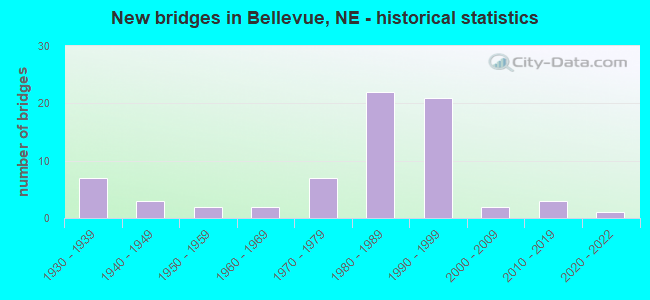
- New bridges - historical statistics
- 71930-1939
- 31940-1949
- 21950-1959
- 21960-1969
- 71970-1979
- 221980-1989
- 211990-1999
- 22000-2009
- 32010-2019
- 12020-2022

- Reconstructed bridges - Historical Statistics
- 11950-1959
- 01960-1969
- 01970-1979
- 11980-1989
- 41990-1999
- 02000-2009
- 32010-2019
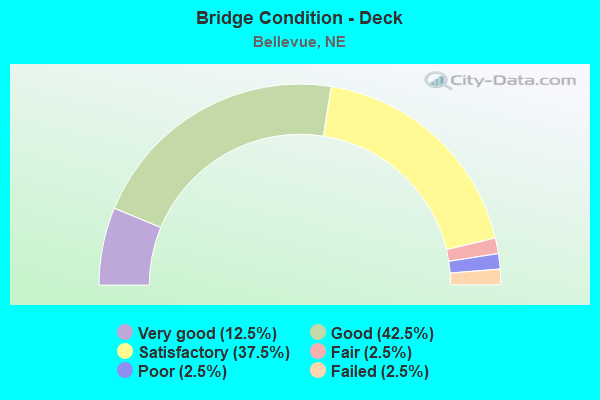
- Bridge Condition - Deck
- 12.5%Very good
- 42.5%Good
- 37.5%Satisfactory
- 2.5%Fair
- 2.5%Poor
- 2.5%Failed
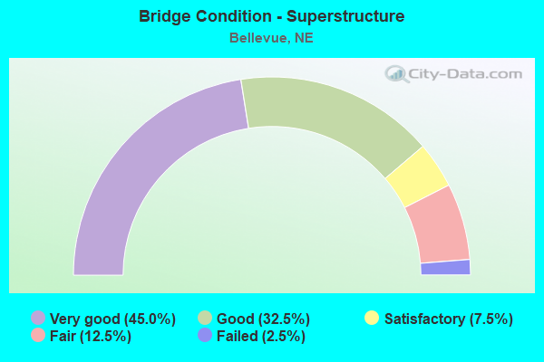
- Bridge Condition - Superstructure
- 45.0%Very good
- 32.5%Good
- 7.5%Satisfactory
- 12.5%Fair
- 2.5%Failed
- Bridge Condition - Substructure
- 15.0%Very good
- 40.0%Good
- 22.5%Satisfactory
- 20.0%Fair
- 2.5%Failed
- Bridge Condition - Channel
- 2.2%Excellent
- 37.8%Very good
- 11.1%Good
- 35.6%Satisfactory
- 6.7%Fair
- 6.7%Poor
- Bridge Condition - Culverts
- 10.5%Excellent
- 26.3%Good
- 31.6%Satisfactory
- 21.1%Fair
- 10.5%Poor
Find on map >> Show street view
Structure Number: U023000410P, Location: KASPER ST @ FT CROOK RD (Lat: 41.167400, Lng: -95.925900), Route carried "on" structure: City street P4, Year Built: 1970, Status: Open, Structure Length: 0.79m (2.59ft), Average Daily Traffic: 2,500 (year 2003), Truck Traffic: 10%, Average Future Daily Traffic: 3,875 (year 2033), Features Intersected: MUD CREEK, Facility Carried by Structure: KASPER STREET
Minimum Vertical Clearance: 30+ m (98+ ft), Kilometerpoint: 0.000, Lanes on structure: 2, Owner: City or Municipal Highway Agency, Approaching Roadway Width: 13.4m (44.0ft), Material/Design: Concrete, Design/Construction: Culvert, Number Of Spans In Main Unit: 2, Length of Maximum Span: 3.7m (12.1ft)
Condition: Channel: Satisfactory, Culverts: Satisfactory, Operating Rating: 33.0 metric tons, Method Used To Determine Operating Rating: Field evaluation and documented engineering judgment, Inventory Rating: 22.0 metric tons, Method Used To Determine Inventory Rating: Field evaluation and documented engineering judgment, Structural Evaluation: Somewhat better than minimum adequacy, Waterway Adequacy: Equal to present minimum criteria, Approach Roadway Alignment: Equal to present desirable criteria, Designated Inspection Frequency: Every 24 months, Inspection Date: September 2020
Find on map >> Show street view
Structure Number: U023000615P, Location: CRNHSKER RD @ FT CROOK RD (Lat: 41.157300, Lng: -95.928600), Route carried "on" structure: City street 5006, Year Built: 1954, Year Reconstructed: 1990, Status: Open, Structure Length: 6.74m (22.11ft), Average Daily Traffic: 11,000 (year 2010), Truck Traffic: 12%, Average Future Daily Traffic: 29,000 (year 2033), Design Load: HS 20, Features Intersected: UP/BN/MUD CR 817-409-P, Facility Carried by Structure: CORNHUSKER RD
Minimum Vertical Clearance: 30+ m (98+ ft), Kilometerpoint: 17.429, Lanes on structure: 4, Base Highway Network: Yes, Owner: City or Municipal Highway Agency, Approaching Roadway Width: 20.4m (66.9ft), Skew: 20 degrees, Material/Design: Prestressed concrete, Design/Construction: Stringer/Multi-beam, Number Of Spans In Main Unit: 4, Length of Maximum Span: 24.1m (79.1ft), Curb or Sidewalk Widths: Left: 1.5m (4.9ft), Right: 0.0m, Curb-To-Curb Width: 20.7m (67.9ft), Out-to-Out Width: 23.3m (76.4ft)
Condition: Deck: Satisfactory, Superstructure: Good, Substructure: Fair, Channel: Poor, Operating Rating: 44.0 metric tons, Method Used To Determine Operating Rating: Load Factor (LF), Inventory Rating: 26.0 metric tons, Method Used To Determine Inventory Rating: Load Factor (LF), Structural Evaluation: Somewhat better than minimum adequacy, Deck Geometry: Superior to present desirable criteria, Underclear: Superior to present desirable criteria, Waterway Adequacy: Equal to present desirable criteria, Approach Roadway Alignment: Equal to present minimum criteria, Length Of Structure Improvement: 6.74m (22.11ft), Designated Inspection Frequency: Every 24 months, Inspection Date: September 2020, Deck Structure Type: Concrete Cast-file-Place, Wearing Surface/Protective System: Wearing Surface: Monolithic Concrete, Deck Protection: Epoxy Coated Reinforcing
Find on map >> Show street view
Structure Number: U023000620P, Location: HARVEL DR @ KAYLEEN DR (Lat: 41.151300, Lng: -95.913300), Route carried "on" structure: City street 5109, Year Built: 1966, Status: Open, Structure Length: 1.25m (4.10ft), Average Daily Traffic: 13,765 (year 2012), Average Future Daily Traffic: 13,765 (year 2033), Features Intersected: STREAM
Minimum Vertical Clearance: 30+ m (98+ ft), Kilometerpoint: 16.684, Lanes on structure: 3, Base Highway Network: Yes, Owner: City or Municipal Highway Agency, Approaching Roadway Width: 12.2m (40.0ft), Skew: 6 degrees, Material/Design: Concrete, Design/Construction: Culvert, Number Of Spans In Main Unit: 2, Length of Maximum Span: 3.0m (9.8ft), Curb or Sidewalk Widths: Left: 1.2m (3.9ft), Right: 1.2m (3.9ft)
Condition: Channel: Satisfactory, Culverts: Satisfactory, Operating Rating: 33.0 metric tons, Method Used To Determine Operating Rating: Field evaluation and documented engineering judgment, Inventory Rating: 22.0 metric tons, Method Used To Determine Inventory Rating: Field evaluation and documented engineering judgment, Structural Evaluation: Somewhat better than minimum adequacy, Waterway Adequacy: Equal to present minimum criteria, Approach Roadway Alignment: Equal to present desirable criteria, Designated Inspection Frequency: Every 24 months, Inspection Date: October 2021
Find on map >> Show street view
Structure Number: U023000815P, Location: .5NW CAPEHART (Lat: 41.133300, Lng: -95.971700), Route carried "on" structure: City street P8, Year Built: 1970, Status: Open, Structure Length: 0.67m (2.20ft), Average Daily Traffic: 875 (year 2003), Truck Traffic: 10%, Average Future Daily Traffic: 1,487 (year 2033), Features Intersected: STREAM, Facility Carried by Structure: QUAIL DRIVE
Minimum Vertical Clearance: 30+ m (98+ ft), Kilometerpoint: 0.000, Lanes on structure: 2, Owner: City or Municipal Highway Agency, Approaching Roadway Width: 9.8m (32.2ft), Material/Design: Concrete, Design/Construction: Culvert, Number Of Spans In Main Unit: 2, Length of Maximum Span: 3.0m (9.8ft)
Condition: Channel: Poor, Culverts: Satisfactory, Operating Rating: 33.0 metric tons, Method Used To Determine Operating Rating: Field evaluation and documented engineering judgment, Inventory Rating: 22.0 metric tons, Method Used To Determine Inventory Rating: Field evaluation and documented engineering judgment, Structural Evaluation: Somewhat better than minimum adequacy, Waterway Adequacy: Equal to present minimum criteria, Approach Roadway Alignment: Equal to present desirable criteria, Designated Inspection Frequency: Every 24 months, Inspection Date: October 2021
Find on map >> Show street view
Structure Number: U023001205P, Location: CAPEHART RD @ KENNEDY EXP (Lat: 41.118300, Lng: -95.936700), Route carried "on" structure: City street 5000, Year Built: 1991, Status: Open, Structure Length: 10.42m (34.19ft), Average Daily Traffic: 24,680 (year 2012), Average Future Daily Traffic: 24,680 (year 2033), Design Load: HS 20, Features Intersected: BIG PAPILLION CREEK
Minimum Vertical Clearance: 30+ m (98+ ft), Kilometerpoint: 16.349, Lanes on structure: 4, Owner: City or Municipal Highway Agency, Approaching Roadway Width: 20.7m (67.9ft), Skew: 20 degrees, Material/Design: Steel continuous, Design/Construction: Stringer/Multi-beam, Number Of Spans In Main Unit: 4, Length of Maximum Span: 33.5m (109.9ft), Curb or Sidewalk Widths: Left: 2.7m (8.9ft), Right: 0.0m, Curb-To-Curb Width: 23.2m (76.1ft), Out-to-Out Width: 26.9m (88.3ft)
Condition: Deck: Satisfactory, Superstructure: Satisfactory, Substructure: Satisfactory, Channel: Satisfactory, Operating Rating: 68.0 metric tons, Method Used To Determine Operating Rating: Load Factor (LF), Inventory Rating: 41.0 metric tons, Method Used To Determine Inventory Rating: Load Factor (LF), Structural Evaluation: Equal to present minimum criteria, Deck Geometry: Superior to present desirable criteria, Waterway Adequacy: Equal to present desirable criteria, Approach Roadway Alignment: Equal to present minimum criteria, Designated Inspection Frequency: Every 24 months, Inspection Date: October 2021, Deck Structure Type: Concrete Cast-file-Place, Wearing Surface/Protective System: Wearing Surface: Monolithic Concrete, Deck Protection: Epoxy Coated Reinforcing
Find on map >> Show street view
Structure Number: U023003905, Location: 2W OF BELLEVUE (Lat: 41.144300, Lng: -95.966800), Route carried "on" structure: City street 5061, Year Built: 1984, Status: Open, Structure Length: 4.97m (16.31ft), Average Daily Traffic: 9,470 (year 2007), Average Future Daily Traffic: 9,470 (year 2033), Design Load: HS 20, Features Intersected: PAPILLION CREEK
Minimum Vertical Clearance: 30+ m (98+ ft), Kilometerpoint: 16.468, Lanes on structure: 2, Owner: City or Municipal Highway Agency, Approaching Roadway Width: 13.4m (44.0ft), Material/Design: Steel continuous, Design/Construction: Stringer/Multi-beam, Number Of Spans In Main Unit: 3, Length of Maximum Span: 18.3m (60.0ft), Curb-To-Curb Width: 12.3m (40.4ft), Out-to-Out Width: 12.9m (42.3ft)
Condition: Deck: Poor, Superstructure: Fair, Substructure: Satisfactory, Channel: Fair, Operating Rating: 53.0 metric tons, Method Used To Determine Operating Rating: Load Factor (LF), Inventory Rating: 31.0 metric tons, Method Used To Determine Inventory Rating: Load Factor (LF), Structural Evaluation: Somewhat better than minimum adequacy, Deck Geometry: Somewhat better than minimum adequacy, Waterway Adequacy: Equal to present minimum criteria, Approach Roadway Alignment: Equal to present desirable criteria, Length Of Structure Improvement: 4.97m (16.31ft), Designated Inspection Frequency: Every 24 months, Inspection Date: September 2020, Deck Structure Type: Concrete Cast-file-Place, Wearing Surface/Protective System: Wearing Surface: Monolithic Concrete, Deck Protection: Epoxy Coated Reinforcing
Find on map >> Show street view
Structure Number: U023004103P, Location: .2S CAPEHART (Lat: 41.116700, Lng: -95.945000), Route carried "on" structure: City street P41, Year Built: 1935, Status: Open, Structure Length: 0.73m (2.40ft), Average Daily Traffic: 950 (year 2003), Truck Traffic: 10%, Average Future Daily Traffic: 1,472 (year 2033), Features Intersected: STREAM, Facility Carried by Structure: LYNNWOOD DR
Minimum Vertical Clearance: 30+ m (98+ ft), Kilometerpoint: 0.000, Lanes on structure: 2, Owner: City or Municipal Highway Agency, Approaching Roadway Width: 9.1m (29.9ft), Skew: 3 degrees, Material/Design: Concrete, Design/Construction: Culvert, Number Of Spans In Main Unit: 2, Length of Maximum Span: 3.0m (9.8ft)
Condition: Channel: Fair, Culverts: Good, Operating Rating: 33.0 metric tons, Method Used To Determine Operating Rating: Field evaluation and documented engineering judgment, Inventory Rating: 22.0 metric tons, Method Used To Determine Inventory Rating: Field evaluation and documented engineering judgment, Structural Evaluation: Somewhat better than minimum adequacy, Waterway Adequacy: Somewhat better than minimum adequacy, Approach Roadway Alignment: Equal to present minimum criteria, Designated Inspection Frequency: Every 24 months, Inspection Date: October 2021
Find on map >> Show street view
Structure Number: U023010815P, Location: .5W .7N CAPEHART (Lat: 41.137300, Lng: -95.975600), Route carried "on" structure: City street 108, Year Built: 1992, Status: Open, Structure Length: 3.11m (10.20ft), Average Daily Traffic: 210 (year 2003), Truck Traffic: 10%, Average Future Daily Traffic: 357 (year 2033), Design Load: HS 20, Features Intersected: STREAM, Facility Carried by Structure: COUNTY HIGHWAY
Minimum Vertical Clearance: 30+ m (98+ ft), Kilometerpoint: 0.000, Lanes on structure: 2, Owner: City or Municipal Highway Agency, Approaching Roadway Width: 7.3m (24.0ft), Material/Design: Prestressed concrete, Design/Construction: Stringer/Multi-beam, Number Of Spans In Main Unit: 1, Length of Maximum Span: 30.5m (100.1ft), Curb-To-Curb Width: 9.8m (32.2ft), Out-to-Out Width: 10.5m (34.4ft)
Condition: Deck: Good, Superstructure: Very good, Substructure: Good, Channel: Satisfactory, Operating Rating: 84.0 metric tons, Method Used To Determine Operating Rating: Load Factor (LF), Inventory Rating: 48.0 metric tons, Method Used To Determine Inventory Rating: Load Factor (LF), Structural Evaluation: Better than present minimum criteria, Deck Geometry: Better than present minimum criteria, Waterway Adequacy: Equal to present desirable criteria, Approach Roadway Alignment: Equal to present desirable criteria, Designated Inspection Frequency: Every 24 months, Inspection Date: September 2020, Deck Structure Type: Concrete Cast-file-Place, Wearing Surface/Protective System: Wearing Surface: Monolithic Concrete, Deck Protection: Epoxy Coated Reinforcing
Find on map >> Show street view
Structure Number: U02302691, Location: _ (Lat: 41.090936, Lng: -95.943578), Route carried "on" structure: City street , Year Built: 1935, Status: Open, Structure Length: 0.95m (3.12ft), Average Daily Traffic: 200 (year 2022), Average Future Daily Traffic: 200 (year 2025), Features Intersected: PAPILLION CREEK TRIB, Facility Carried by Structure: _
Minimum Vertical Clearance: 30+ m (98+ ft), Kilometerpoint: 0.000, Lanes on structure: 2, Owner: Private, Approaching Roadway Width: 7.2m (23.6ft), Material/Design: Concrete, Design/Construction: Culvert, Number Of Spans In Main Unit: 3, Length of Maximum Span: 3.0m (9.8ft)
Condition: Channel: Very good, Culverts: Good, Operating Rating: 33.0 metric tons, Method Used To Determine Operating Rating: Field evaluation and documented engineering judgment, Inventory Rating: 24.0 metric tons, Method Used To Determine Inventory Rating: Field evaluation and documented engineering judgment, Structural Evaluation: Equal to present minimum criteria, Waterway Adequacy: Equal to present desirable criteria, Approach Roadway Alignment: Equal to present minimum criteria, Designated Inspection Frequency: Every 24 months, Inspection Date: August 2021
Find on map >> Show street view
Structure Number: U023026915, Location: _ (Lat: 41.090475, Lng: -95.940503), Route carried "on" structure: City street , Year Built: 1935, Status: Open, Structure Length: 1.97m (6.46ft), Average Daily Traffic: 200 (year 2022), Average Future Daily Traffic: 200 (year 2025), Features Intersected: PAPILLION CREEK TRIB, Facility Carried by Structure: _
Minimum Vertical Clearance: 30+ m (98+ ft), Kilometerpoint: 0.000, Lanes on structure: 2, Owner: Private, Approaching Roadway Width: 11.0m (36.1ft), Material/Design: Prestressed concrete, Design/Construction: Stringer/Multi-beam, Number Of Spans In Main Unit: 1, Length of Maximum Span: 18.3m (60.0ft), Curb-To-Curb Width: 11.0m (36.1ft), Out-to-Out Width: 15.2m (49.9ft)
Condition: Deck: Good, Superstructure: Very good, Substructure: Good, Channel: Satisfactory, Operating Rating: 33.0 metric tons, Method Used To Determine Operating Rating: Field evaluation and documented engineering judgment, Inventory Rating: 24.0 metric tons, Method Used To Determine Inventory Rating: Field evaluation and documented engineering judgment, Structural Evaluation: Equal to present minimum criteria, Deck Geometry: Equal to present desirable criteria, Waterway Adequacy: Equal to present minimum criteria, Approach Roadway Alignment: Equal to present minimum criteria, Designated Inspection Frequency: Every 24 months, Inspection Date: August 2021, Deck Structure Type: Concrete Cast-file-Place, Wearing Surface/Protective System: Wearing Surface: Monolithic Concrete
Find on map >> Show street view
Structure Number: U023031235, Location: SHILLING DR @ FT CROOK RD (Lat: 41.118700, Lng: -95.929300), Route carried "on" structure: City street 312, Year Built: 1935, Status: Closed, Structure Length: 6.46m (21.19ft), Average Daily Traffic: 2,000 (year 2003), Truck Traffic: 10%, Average Future Daily Traffic: 3,100 (year 2033), Features Intersected: UP/BNSF RR 433-019-N, Facility Carried by Structure: SHILLING DR
Minimum Vertical Clearance: 30+ m (98+ ft), Kilometerpoint: 0.000, Lanes on structure: 2, Owner: City or Municipal Highway Agency, Approaching Roadway Width: 7.0m (23.0ft), Skew: 1 degrees, Material/Design: Wood or Timber, Design/Construction: Stringer/Multi-beam, Number Of Spans In Main Unit: 12, Length of Maximum Span: 9.4m (30.8ft), Curb or Sidewalk Widths: Left: 0.2m (0.7ft), Right: 0.2m (0.7ft), Curb-To-Curb Width: 6.0m (19.7ft), Out-to-Out Width: 6.4m (21.0ft)
Condition: Deck: Failed, Superstructure: Failed, Substructure: Failed, Underclear: Somewhat better than minimum adequacy, Approach Roadway Alignment: Meets minimum limits, Bridge Posting: Required (Relationship of Operating Rating to Maximum Legal Load: > 39.9% below), Length Of Structure Improvement: 6.46m (21.19ft), Designated Inspection Frequency: Every 24 months, Inspection Date: October 2021, Deck Structure Type: Concrete Cast-file-Place, Wearing Surface/Protective System: Wearing Surface: Bituminous
Find on map >> Show street view
Structure Number: U0230B4335, Location: JCT N370/FT CROOK RD .2S (Lat: 41.135400, Lng: -95.926500), Route carried "on" structure: City street 5145, Year Built: 1941, Year Reconstructed: 1990, Status: Open, Structure Length: 0.70m (2.30ft), Average Daily Traffic: 13,470 (year 2012), Average Future Daily Traffic: 13,470 (year 2033), Features Intersected: STREAM
Minimum Vertical Clearance: 30+ m (98+ ft), Kilometerpoint: 16.367, Lanes on structure: 4, Base Highway Network: Yes, Owner: City or Municipal Highway Agency, Approaching Roadway Width: 31.1m (102.0ft), Skew: 21 degrees, Material/Design: Concrete, Design/Construction: Culvert, Number Of Spans In Main Unit: 3, Length of Maximum Span: 3.0m (9.8ft)
Condition: Channel: Satisfactory, Culverts: Fair, Operating Rating: 33.0 metric tons, Method Used To Determine Operating Rating: Field evaluation and documented engineering judgment, Inventory Rating: 22.0 metric tons, Method Used To Determine Inventory Rating: Field evaluation and documented engineering judgment, Structural Evaluation: Somewhat better than minimum adequacy, Waterway Adequacy: Equal to present desirable criteria, Approach Roadway Alignment: Equal to present desirable criteria, Designated Inspection Frequency: Every 24 months, Inspection Date: October 2020
Find on map >> Show street view
Structure Number: U0230B434, Location: JCT N370/FT CROOK RD .1S (Lat: 41.137900, Lng: -95.926500), Route carried "on" structure: City street 5145, Year Built: 1941, Year Reconstructed: 2019, Status: Open, Structure Length: 1.34m (4.40ft), Average Daily Traffic: 13,470 (year 2012), Average Future Daily Traffic: 13,470 (year 2033), Design Load: HS 20, Features Intersected: BETZ DITCH, Facility Carried by Structure: FT CROOK ROAD
Minimum Vertical Clearance: 30+ m (98+ ft), Kilometerpoint: 16.396, Lanes on structure: 4, Base Highway Network: Yes, Owner: City or Municipal Highway Agency, Approaching Roadway Width: 31.1m (102.0ft), Skew: 20 degrees, Material/Design: Concrete, Design/Construction: Culvert, Number Of Spans In Main Unit: 5, Length of Maximum Span: 2.4m (7.9ft)
Condition: Channel: Fair, Culverts: Fair, Operating Rating: 33.0 metric tons, Method Used To Determine Operating Rating: Field evaluation and documented engineering judgment, Inventory Rating: 22.0 metric tons, Method Used To Determine Inventory Rating: Field evaluation and documented engineering judgment, Structural Evaluation: Somewhat better than minimum adequacy, Waterway Adequacy: Equal to present desirable criteria, Approach Roadway Alignment: Equal to present desirable criteria, Length Of Structure Improvement: 1.34m (4.40ft), Designated Inspection Frequency: Every 24 months, Inspection Date: September 2020
Find on map >> Show street view
Structure Number: U0230B4355, Location: FTCROOK 150' S PEOPLES RD (Lat: 41.161900, Lng: -95.925200), Route carried "on" structure: City street 5145, Year Built: 1941, Year Reconstructed: 1961, Status: Open, Structure Length: 0.64m (2.10ft), Average Daily Traffic: 13,710 (year 2012), Average Future Daily Traffic: 13,710 (year 2033), Design Load: HS 20, Features Intersected: MUD CREEK
Minimum Vertical Clearance: 30+ m (98+ ft), Kilometerpoint: 16.661, Lanes on structure: 6, Base Highway Network: Yes, Owner: City or Municipal Highway Agency, Approaching Roadway Width: 31.1m (102.0ft), Skew: 20 degrees, Material/Design: Concrete, Design/Construction: Culvert, Number Of Spans In Main Unit: 2, Length of Maximum Span: 3.0m (9.8ft)
Condition: Channel: Satisfactory, Culverts: Fair, Operating Rating: 33.0 metric tons, Method Used To Determine Operating Rating: Field evaluation and documented engineering judgment, Inventory Rating: 22.0 metric tons, Method Used To Determine Inventory Rating: Field evaluation and documented engineering judgment, Structural Evaluation: Somewhat better than minimum adequacy, Waterway Adequacy: Better than present minimum criteria, Approach Roadway Alignment: Equal to present desirable criteria, Designated Inspection Frequency: Every 24 months, Inspection Date: September 2020
Find on map >> Show street view
Structure Number: U0230C4305, Location: PEOPLES RD @ FT CROOK RD (Lat: 41.162600, Lng: -95.924900), Route carried "on" structure: City street 43, Year Built: 1972, Status: Open, Structure Length: 0.98m (3.22ft), Average Daily Traffic: 200 (year 2003), Truck Traffic: 10%, Average Future Daily Traffic: 310 (year 2033), Features Intersected: MUD CREEK, Facility Carried by Structure: PEOPLES ROAD
Minimum Vertical Clearance: 30+ m (98+ ft), Kilometerpoint: 0.000, Lanes on structure: 2, Owner: City or Municipal Highway Agency, Approaching Roadway Width: 7.3m (24.0ft), Material/Design: Prestressed concrete, Design/Construction: Tee Beam, Number Of Spans In Main Unit: 1, Length of Maximum Span: 9.4m (30.8ft), Curb or Sidewalk Widths: Left: 0.4m (1.3ft), Right: 0.4m (1.3ft), Curb-To-Curb Width: 8.4m (27.6ft), Out-to-Out Width: 9.1m (29.9ft)
Condition: Deck: Fair, Superstructure: Fair, Substructure: Fair, Channel: Satisfactory, Operating Rating: 33.0 metric tons, Method Used To Determine Operating Rating: Field evaluation and documented engineering judgment, Inventory Rating: 22.0 metric tons, Method Used To Determine Inventory Rating: Field evaluation and documented engineering judgment, Structural Evaluation: Somewhat better than minimum adequacy, Deck Geometry: Somewhat better than minimum adequacy, Waterway Adequacy: Equal to present minimum criteria, Approach Roadway Alignment: Equal to present minimum criteria, Length Of Structure Improvement: 0.98m (3.22ft), Designated Inspection Frequency: Every 24 months, Inspection Date: September 2020, Deck Structure Type: Concrete Cast-file-Place, Wearing Surface/Protective System: Wearing Surface: Monolithic Concrete
Find on map >> Show street view
Structure Number: U0230C431, Location: 500' S JCT AVERY/FT CROOK (Lat: 41.163600, Lng: -95.924800), Route carried "on" structure: ServiceOther road L4, Year Built: 1935, Year Reconstructed: 2017, Status: Posted for load, Structure Length: 1.16m (3.81ft), Average Daily Traffic: 250 (year 2003), Truck Traffic: 10%, Average Future Daily Traffic: 387 (year 2033), Features Intersected: MUD CREEK, Facility Carried by Structure: ACCESS ROAD
Minimum Vertical Clearance: 30+ m (98+ ft), Kilometerpoint: 0.000, Lanes on structure: 2, Owner: City or Municipal Highway Agency, Approaching Roadway Width: 7.9m (25.9ft), Material/Design: Prestressed concrete, Design/Construction: Tee Beam, Number Of Spans In Main Unit: 1, Length of Maximum Span: 11.0m (36.1ft), Curb or Sidewalk Widths: Left: 0.2m (0.7ft), Right: 0.2m (0.7ft), Curb-To-Curb Width: 7.3m (24.0ft), Out-to-Out Width: 7.7m (25.3ft)
Condition: Deck: Satisfactory, Superstructure: Satisfactory, Substructure: Satisfactory, Channel: Satisfactory, Operating Rating: 24.0 metric tons, Method Used To Determine Operating Rating: Field evaluation and documented engineering judgment, Inventory Rating: 17.0 metric tons, Method Used To Determine Inventory Rating: Field evaluation and documented engineering judgment, Structural Evaluation: Somewhat better than minimum adequacy, Deck Geometry: Somewhat better than minimum adequacy, Waterway Adequacy: Equal to present minimum criteria, Approach Roadway Alignment: Equal to present minimum criteria, Length Of Structure Improvement: 1.16m (3.81ft), Designated Inspection Frequency: Every 24 months, Inspection Date: October 2021, Deck Structure Type: Other, Wearing Surface/Protective System: Wearing Surface: Other
Find on map >> Show street view
Structure Number: U0230C4315, Location: 150' S JCT AVERY/FT C (Lat: 41.164600, Lng: -95.924800), Route carried "on" structure: ServiceOther road K4, Year Built: 1935, Status: Open, Structure Length: 1.13m (3.71ft), Average Daily Traffic: 250 (year 2003), Truck Traffic: 10%, Average Future Daily Traffic: 387 (year 2033), Features Intersected: MUD CREEK, Facility Carried by Structure: ACCESS RD
Minimum Vertical Clearance: 30+ m (98+ ft), Kilometerpoint: 0.000, Lanes on structure: 2, Owner: City or Municipal Highway Agency, Approaching Roadway Width: 7.9m (25.9ft), Material/Design: Prestressed concrete, Design/Construction: Tee Beam, Number Of Spans In Main Unit: 1, Length of Maximum Span: 10.7m (35.1ft), Curb or Sidewalk Widths: Left: 0.8m (2.6ft), Right: 0.8m (2.6ft), Curb-To-Curb Width: 7.3m (24.0ft), Out-to-Out Width: 8.9m (29.2ft)
Condition: Deck: Satisfactory, Superstructure: Fair, Substructure: Fair, Channel: Poor, Operating Rating: 33.0 metric tons, Method Used To Determine Operating Rating: Field evaluation and documented engineering judgment, Inventory Rating: 22.0 metric tons, Method Used To Determine Inventory Rating: Field evaluation and documented engineering judgment, Structural Evaluation: Somewhat better than minimum adequacy, Deck Geometry: Somewhat better than minimum adequacy, Waterway Adequacy: Equal to present minimum criteria, Approach Roadway Alignment: Equal to present minimum criteria, Designated Inspection Frequency: Every 24 months, Inspection Date: September 2020, Deck Structure Type: Concrete Cast-file-Place, Wearing Surface/Protective System: Wearing Surface: Monolithic Concrete
Find on map >> Show street view
Structure Number: U0230F4305, Location: BETZ RD @ N370 (Lat: 41.140700, Lng: -95.922100), Route carried "on" structure: City street 5107, Year Built: 1988, Status: Open, Structure Length: 0.85m (2.79ft), Average Daily Traffic: 2,820 (year 2012), Truck Traffic: 4%, Average Future Daily Traffic: 2,820 (year 2033), Design Load: HS 20, Features Intersected: STREAM
Minimum Vertical Clearance: 30+ m (98+ ft), Kilometerpoint: 16.098, Lanes on structure: 2, Owner: City or Municipal Highway Agency, Approaching Roadway Width: 10.1m (33.1ft), Material/Design: Concrete, Design/Construction: Culvert, Number Of Spans In Main Unit: 2, Length of Maximum Span: 3.7m (12.1ft)
Condition: Channel: Good, Culverts: Satisfactory, Operating Rating: 33.0 metric tons, Method Used To Determine Operating Rating: Field evaluation and documented engineering judgment, Inventory Rating: 22.0 metric tons, Method Used To Determine Inventory Rating: Field evaluation and documented engineering judgment, Structural Evaluation: Somewhat better than minimum adequacy, Waterway Adequacy: Equal to present desirable criteria, Approach Roadway Alignment: Better than present minimum criteria, Designated Inspection Frequency: Every 24 months, Inspection Date: October 2021
Find on map >> Show street view
Structure Number: S075 08037L, Location: JCT US 75/CAPEHART RD (Lat: 41.117800, Lng: -95.934900), Route carried "under" structure: County highway 5000, Year Built: 1992, Structure Length: 0. m, Average Daily Traffic: 24,680 (year 2012), Features Intersected: FAU 5000/CAPEHART RD, Facility Carried by Structure: SB-US75
Minimum Vertical Clearance: 5.08m (16.67ft), Kilometerpoint: 16.375, Lanes on structure: 4, Lanes under structure: 4, Material/Design: Prestressed concrete continuous, Design/Construction: Stringer/Multi-beam, Length of Maximum Span: 28.0m (91.9ft)
Find on map >> Show street view
Structure Number: S075 08037R, Location: JCT US 75/CAPEHART RD (Lat: 41.117800, Lng: -95.934600), Route carried "under" structure: County highway 5000, Year Built: 1992, Structure Length: 0. m, Average Daily Traffic: 24,680 (year 2012), Features Intersected: FAU 5000/CAPEHART RD, Facility Carried by Structure: NB-US75
Minimum Vertical Clearance: 5.08m (16.67ft), Kilometerpoint: 16.372, Lanes on structure: 4, Lanes under structure: 4, Material/Design: Prestressed concrete continuous, Design/Construction: Stringer/Multi-beam, Length of Maximum Span: 28.0m (91.9ft)
Find on map >> Show street view
Structure Number: S075 08192L, Location: JCT US75/N370 (Lat: 41.140000, Lng: -95.937300), Route carried "under" structure: State highway 370, Year Built: 1990, Structure Length: 0. m, Average Daily Traffic: 34,435 (year 2012), Truck Traffic: 1%, Features Intersected: N370, Facility Carried by Structure: SB-US75
Minimum Vertical Clearance: 5.10m (16.73ft), Kilometerpoint: 2.572, Lanes on structure: 4, Lanes under structure: 4, Material/Design: Steel continuous, Design/Construction: Stringer/Multi-beam, Length of Maximum Span: 32.9m (107.9ft)
Find on map >> Show street view
Structure Number: S075 08192R, Location: JCT US75/N370 (Lat: 41.140000, Lng: -95.937000), Route carried "under" structure: State highway 370, Year Built: 1990, Structure Length: 0. m, Average Daily Traffic: 25,745 (year 2012), Truck Traffic: 2%, Features Intersected: N370, Facility Carried by Structure: NB-US75
Minimum Vertical Clearance: 5.10m (16.73ft), Kilometerpoint: 2.575, Lanes on structure: 4, Lanes under structure: 4, Material/Design: Steel continuous, Design/Construction: Stringer/Multi-beam, Length of Maximum Span: 32.9m (107.9ft)
Find on map >> Show street view
Structure Number: S075 08323, Location: CORNHUSKER RD @ US75 (Lat: 41.158900, Lng: -95.938700), Route carried "under" structure: US 75, Year Built: 1987, Structure Length: 0. m, Average Daily Traffic: 58,550 (year 2012), Truck Traffic: 4%, Features Intersected: US75, Facility Carried by Structure: CORNHUSKER ROAD
Minimum Vertical Clearance: 5.05m (16.57ft), Kilometerpoint: 13.395, Lanes on structure: 4, Lanes under structure: 4, Material/Design: Steel continuous, Design/Construction: Stringer/Multi-beam, Length of Maximum Span: 37.5m (123.0ft)
Find on map >> Show street view
Structure Number: S075 08324, Location: CRNHSKER RD @ US75 (Lat: 41.159000, Lng: -95.939000), Route carried "under" structure: US 75, Year Built: 1991, Structure Length: 0. m, Average Daily Traffic: 53,350 (year 2008), Truck Traffic: 4%, Features Intersected: US75, Facility Carried by Structure: PEDESTRIAN OVRPASS
Minimum Vertical Clearance: 6.42m (21.06ft), Kilometerpoint: 13.393, Lanes on structure: 4, Lanes under structure: 4, Material/Design: Steel continuous, Design/Construction: Stringer/Multi-beam, Length of Maximum Span: 37.5m (123.0ft)
Find on map >> Show street view
Structure Number: S075 08444, Location: US75/CHILDS ROAD (Lat: 41.176500, Lng: -95.939700), Route carried "under" structure: US 75, Year Built: 1992, Structure Length: 0. m, Average Daily Traffic: 58,550 (year 2012), Truck Traffic: 4%, Features Intersected: US75, Facility Carried by Structure: FAU 5012/CHILDS RD
Minimum Vertical Clearance: 5.15m (16.90ft), Kilometerpoint: 13.589, Lanes on structure: 4, Lanes under structure: 4, Material/Design: Steel continuous, Design/Construction: Stringer/Multi-beam, Length of Maximum Span: 34.7m (113.8ft)
Find on map >> Show street view
Structure Number: S075 08495L, Location: JCT US75/CHANDLER RD (Lat: 41.183700, Lng: -95.938100), Route carried "under" structure: City street 5020, Year Built: 1988, Structure Length: 0. m, Average Daily Traffic: 10,345 (year 2012), Truck Traffic: 4%, Features Intersected: FAU 5020/CHANDLER RD, Facility Carried by Structure: SB-US75
Minimum Vertical Clearance: 5.28m (17.32ft), Kilometerpoint: 16.340, Lanes on structure: 4, Lanes under structure: 4, Material/Design: Steel continuous, Design/Construction: Stringer/Multi-beam, Length of Maximum Span: 28.3m (92.8ft)
Find on map >> Show street view
Structure Number: S075 08495R, Location: JCT US75/CHANDLER RD (Lat: 41.183700, Lng: -95.937900), Route carried "under" structure: City street 5020, Year Built: 1988, Structure Length: 0. m, Average Daily Traffic: 10,345 (year 2012), Truck Traffic: 4%, Features Intersected: FAU 5020/CHANDLER RD, Facility Carried by Structure: NB-US75
Minimum Vertical Clearance: 5.28m (17.32ft), Kilometerpoint: 16.343, Lanes on structure: 4, Lanes under structure: 4, Material/Design: Steel continuous, Design/Construction: Stringer/Multi-beam, Length of Maximum Span: 28.3m (92.8ft)
Find on map >> Show street view
Structure Number: S370 01654, Location: FT CROOK RD/N370 INTRCHG (Lat: 41.140200, Lng: -95.926500), Route carried "under" structure: City street 5145, Year Built: 1989, Structure Length: 0. m, Average Daily Traffic: 10,380 (year 2012), Features Intersected: FT CROOK RD/FAU 5145, Facility Carried by Structure: CITY STREET
Minimum Vertical Clearance: 5.05m (16.57ft), Kilometerpoint: 16.422, Lanes on structure: 4, Lanes under structure: 4, Material/Design: Steel, Design/Construction: Box Beam or Girders - Multiple, Length of Maximum Span: 59.4m (194.9ft)
Find on map >> Show street view
Structure Number: U0230A081, Location: GALVIN @ HANSEN (Lat: 41.146700, Lng: -95.913300), Route carried "under" structure: City street 5006, Year Built: 1973, Structure Length: 0. m, Average Daily Traffic: 15,500 (year 2006), Features Intersected: PEDESTRIAN OVERPASS, Facility Carried by Structure: PEDESTRIAN OVRPASS
Minimum Vertical Clearance: 4.34m (14.24ft), Kilometerpoint: 17.602, Lanes on structure: 5, Lanes under structure: 5, Material/Design: Steel, Design/Construction: Stringer/Multi-beam, Length of Maximum Span: 40.2m (131.9ft)