Bridge Statistics for Bellevue, Washington (WA)
Condition, Traffic, Stress, Structural Evaluation, Project Costs
- National Bridge Inventory (NBI) Statistics
- 165Number of bridges
- 4,610ft / 1,405mTotal length
- $932,748,000Total costs
- 7,301,988Total average daily traffic
- 340,573Total average daily truck traffic
- National Bridge Inventory (NBI) Registered Bridges for Bellevue
- No street view available for this location
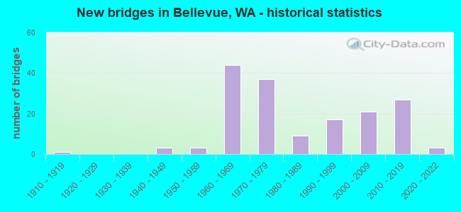
- New bridges - historical statistics
- 11910-1919
- 31940-1949
- 31950-1959
- 441960-1969
- 371970-1979
- 91980-1989
- 171990-1999
- 212000-2009
- 272010-2019
- 32020-2022
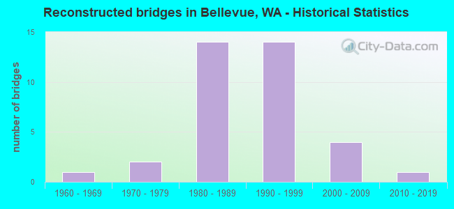
- Reconstructed bridges - Historical Statistics
- 11960-1969
- 21970-1979
- 141980-1989
- 141990-1999
- 42000-2009
- 12010-2019
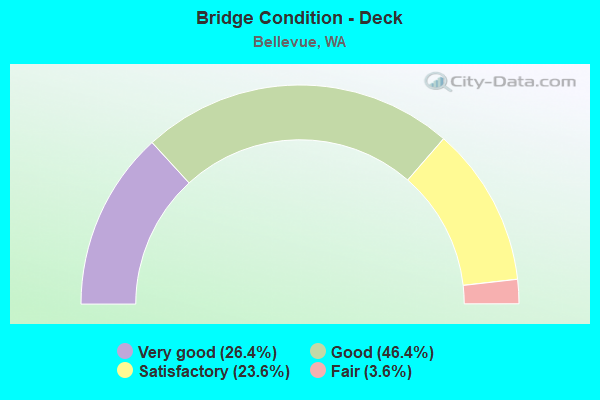
- Bridge Condition - Deck
- 26.4%Very good
- 46.4%Good
- 23.6%Satisfactory
- 3.6%Fair
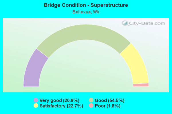
- Bridge Condition - Superstructure
- 20.9%Very good
- 54.5%Good
- 22.7%Satisfactory
- 1.8%Poor
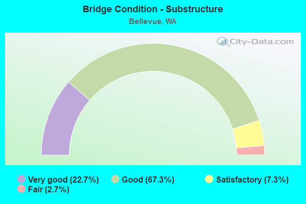
- Bridge Condition - Substructure
- 22.7%Very good
- 67.3%Good
- 7.3%Satisfactory
- 2.7%Fair
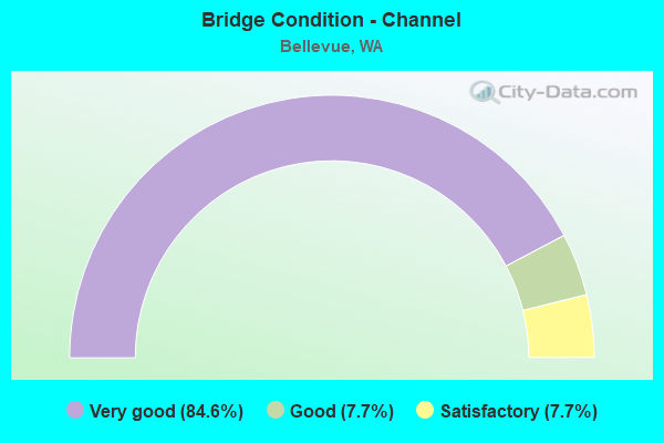
- Bridge Condition - Channel
- 84.6%Very good
- 7.7%Good
- 7.7%Satisfactory
Find on map >> Show street view
Structure Number: 89154, Location: 0.1 N JCT NEWPORT KEY (Lat: 47.572797, Lng: -122.188928), Route carried "on" structure: City street 7530, Year Built: 2019, Status: Open, Structure Length: 1.07m (3.51ft), Average Daily Traffic: 250 (year 2018), Truck Traffic: 1%, Average Future Daily Traffic: 250 (year 2040), Design Load: HL 93, Features Intersected: COAL CREEK, Facility Carried by Structure: SKAGIT KEY
Minimum Vertical Clearance: 30+ m (98+ ft), Kilometerpoint: 0.001, Lanes on structure: 2, Owner: City or Municipal Highway Agency, Approaching Roadway Width: 10.1m (33.1ft), Skew: 2 degrees, Material/Design: Prestressed concrete, Design/Construction: Stringer/Multi-beam, Number Of Spans In Main Unit: 1, Length of Maximum Span: 8.2m (26.9ft), Curb or Sidewalk Widths: Left: 1.8m (5.9ft), Right: 1.8m (5.9ft), Curb-To-Curb Width: 10.1m (33.1ft), Out-to-Out Width: 14.6m (47.9ft)
Condition: Deck: Very good, Superstructure: Very good, Substructure: Very good, Channel: Very good, Operating Rating: 55.7 metric tons, Method Used To Determine Operating Rating: Load and Resistance Factor Rating (LRFR) rating reported by rating factor(RF) method using HL-93 loadings, Inventory Rating: 39.2 metric tons, Method Used To Determine Inventory Rating: Load and Resistance Factor Rating (LRFR) rating reported by rating factor(RF) method using HL-93 loadings, Structural Evaluation: Equal to present desirable criteria, Deck Geometry: Better than present minimum criteria, Waterway Adequacy: Equal to present desirable criteria, Approach Roadway Alignment: Equal to present desirable criteria, Length Of Structure Improvement: 1.07m (3.51ft), Designated Inspection Frequency: Every 24 months, Inspection Date: May 2020, Bridge Improvement Cost: $245,000, Roadway Improvement Cost: $49,000, Total Project Cost: $490,000 ( Estimate for 2014), Deck Structure Type: Concrete Precast Panels, Wearing Surface/Protective System: Wearing Surface: Bituminous, Membrane: Preformed Fabric, Deck Protection: Epoxy Coated Reinforcing
Find on map >> Show street view
Structure Number: 89155, Location: 0.2 W JCT CASCADE KEY (Lat: 47.570753, Lng: -122.187158), Route carried "on" structure: City street 7532, Year Built: 2019, Status: Open, Structure Length: 1.01m (3.31ft), Average Daily Traffic: 250 (year 2018), Truck Traffic: 5%, Average Future Daily Traffic: 250 (year 2040), Design Load: HL 93, Features Intersected: COAL CREEK, Facility Carried by Structure: GLACIER KEY
Minimum Vertical Clearance: 30+ m (98+ ft), Kilometerpoint: 0.001, Lanes on structure: 2, Owner: City or Municipal Highway Agency, Approaching Roadway Width: 10.1m (33.1ft), Material/Design: Prestressed concrete, Design/Construction: Stringer/Multi-beam, Number Of Spans In Main Unit: 1, Length of Maximum Span: 7.6m (24.9ft), Curb or Sidewalk Widths: Left: 1.8m (5.9ft), Right: 1.8m (5.9ft), Curb-To-Curb Width: 10.1m (33.1ft), Out-to-Out Width: 14.6m (47.9ft)
Condition: Deck: Very good, Superstructure: Very good, Substructure: Very good, Channel: Very good, Operating Rating: 60.6 metric tons, Method Used To Determine Operating Rating: Load and Resistance Factor Rating (LRFR) rating reported by rating factor(RF) method using HL-93 loadings, Inventory Rating: 38.6 metric tons, Method Used To Determine Inventory Rating: Load and Resistance Factor Rating (LRFR) rating reported by rating factor(RF) method using HL-93 loadings, Structural Evaluation: Equal to present desirable criteria, Deck Geometry: Better than present minimum criteria, Waterway Adequacy: Equal to present desirable criteria, Approach Roadway Alignment: Equal to present desirable criteria, Length Of Structure Improvement: 1.01m (3.31ft), Designated Inspection Frequency: Every 24 months, Inspection Date: May 2020, Bridge Improvement Cost: $231,000, Roadway Improvement Cost: $46,000, Total Project Cost: $462,000 ( Estimate for 2014), Deck Structure Type: Concrete Precast Panels, Wearing Surface/Protective System: Wearing Surface: Bituminous, Membrane: Preformed Fabric, Deck Protection: Epoxy Coated Reinforcing
Find on map >> Show street view
Structure Number: 8918, Location: 0.30 N NE 12TH ST (Lat: 47.624225, Lng: -122.175089), Route carried "on" structure: City street 75, Year Built: 2019, Status: Open, Structure Length: 1.25m (4.10ft), Average Daily Traffic: 15,540 (year 2020), Truck Traffic: 15%, Average Future Daily Traffic: 32,000 (year 2037), Design Load: HL 93, Features Intersected: SOUND TRANSIT LIGHT RAIL, Facility Carried by Structure: 124TH AVE NE
Minimum Vertical Clearance: 30+ m (98+ ft), Kilometerpoint: 0.001, Lanes on structure: 5, Owner: City or Municipal Highway Agency, Approaching Roadway Width: 17.7m (58.1ft), Skew: 1 degrees, Material/Design: Prestressed concrete, Design/Construction: Stringer/Multi-beam, Number Of Spans In Main Unit: 1, Length of Maximum Span: 11.9m (39.0ft), Curb or Sidewalk Widths: Left: 3.0m (9.8ft), Right: 2.4m (7.9ft), Curb-To-Curb Width: 17.7m (58.1ft), Out-to-Out Width: 28.1m (92.2ft)
Condition: Deck: Very good, Superstructure: Very good, Substructure: Very good, Operating Rating: 63.8 metric tons, Method Used To Determine Operating Rating: Load and Resistance Factor Rating (LRFR) rating reported by rating factor(RF) method using HL-93 loadings, Inventory Rating: 32.4 metric tons, Method Used To Determine Inventory Rating: Load and Resistance Factor Rating (LRFR) rating reported by rating factor(RF) method using HL-93 loadings, Structural Evaluation: Equal to present desirable criteria, Deck Geometry: High priority of replacement, Underclear: High priority of corrective action, Approach Roadway Alignment: Equal to present desirable criteria, Length Of Structure Improvement: 1.25m (4.10ft), Designated Inspection Frequency: Every 24 months, Inspection Date: October 2020, Bridge Improvement Cost: $492,000, Roadway Improvement Cost: $98,000, Total Project Cost: $984,000 ( Estimate for 2014), Deck Structure Type: Concrete Cast-file-Place, Wearing Surface/Protective System: Wearing Surface: Monolithic Concrete, Deck Protection: Epoxy Coated Reinforcing
Find on map >> Show street view
Structure Number: QZ, Location: 0.5 MI N OF JCT I-90 (Lat: 47.571244, Lng: -122.104600), Route carried "under" structure: City street 7020, Year Built: 1950, Structure Length: 0. m, Average Daily Traffic: 13,900 (year 2019), Truck Traffic: 3%, Features Intersected: WEST LAKE SAMMAMISH PKWY, Facility Carried by Structure: PED WALKWAY UC
Minimum Vertical Clearance: 5.03m (16.50ft), Kilometerpoint: 0.001, Lanes under structure: 2, Material/Design: Steel, Design/Construction: Girder and Floorbeam System, Length of Maximum Span: 21.0m (68.9ft)
Find on map >> Show street view
Structure Number: 7596A, Location: 3.6 N JCT I-90 (Lat: 47.629778, Lng: -122.188333), Route carried "under" structure: Ramp Interstate 405, Year Built: 1965, Structure Length: 0. m, Average Daily Traffic: 8,969 (year 2019), Truck Traffic: 7%, Features Intersected: N-W RAMP
Minimum Vertical Clearance: 5.23m (17.16ft), Kilometerpoint: 0.290, Lanes on structure: 6, Lanes under structure: 1, Material/Design: Prestressed concrete continuous, Design/Construction: Stringer/Multi-beam, Length of Maximum Span: 28.7m (94.2ft)
Find on map >> Show street view
Structure Number: 7596B, Location: 3.6 N JCT I-90 (Lat: 47.630056, Lng: -122.188611), Route carried "under" structure: Ramp Interstate 405, Year Built: 1966, Structure Length: 0. m, Average Daily Traffic: 8,969 (year 2019), Truck Traffic: 7%, Features Intersected: N-W RAMP
Minimum Vertical Clearance: 5.41m (17.75ft), Kilometerpoint: 0.322, Lanes on structure: 5, Lanes under structure: 1, Material/Design: Prestressed concrete continuous, Design/Construction: Stringer/Multi-beam, Length of Maximum Span: 24.1m (79.1ft)
Find on map >> Show street view
Structure Number: 7596C, Location: JCT I-405 (Lat: 47.631914, Lng: -122.187817), Route carried "under" structure: State highway 520, Year Built: 1966, Structure Length: 0. m, Average Daily Traffic: 105,102 (year 2019), Truck Traffic: 3%, Features Intersected: SR 520, Facility Carried by Structure: I-405
Minimum Vertical Clearance: 5.64m (18.50ft), Kilometerpoint: 11.185, Lanes on structure: 5, Lanes under structure: 6, Material/Design: Prestressed concrete, Design/Construction: Stringer/Multi-beam, Length of Maximum Span: 24.1m (79.1ft)
Find on map >> Show street view
Structure Number: 7596D, Location: JCT I-405 (Lat: 47.632056, Lng: -122.188222), Route carried "under" structure: State highway 520, Year Built: 1966, Structure Length: 0. m, Average Daily Traffic: 105,102 (year 2019), Truck Traffic: 3%, Features Intersected: SR 520, Facility Carried by Structure: I-405
Minimum Vertical Clearance: 5.49m (18.01ft), Kilometerpoint: 11.153, Lanes on structure: 6, Lanes under structure: 6, Material/Design: Prestressed concrete, Design/Construction: Stringer/Multi-beam, Length of Maximum Span: 22.3m (73.2ft)
Find on map >> Show street view
Structure Number: 7596F, Location: JCT I-405 (Lat: 47.632917, Lng: -122.189944), Route carried "under" structure: State highway 520, Year Built: 1966, Structure Length: 0. m, Average Daily Traffic: 84,448 (year 2019), Truck Traffic: 3%, Features Intersected: SR 520, Facility Carried by Structure: N-W RAMP
Minimum Vertical Clearance: 5.46m (17.91ft), Kilometerpoint: 10.992, Lanes on structure: 1, Lanes under structure: 6, Material/Design: Concrete continuous, Design/Construction: Slab, Length of Maximum Span: 22.6m (74.1ft)
Find on map >> Show street view
Structure Number: 7623B, Location: 3.8 N JCT SR 900 (Lat: 47.557000, Lng: -122.190333), Route carried "under" structure: Interstate 405, Year Built: 1965, Structure Length: 0. m, Average Daily Traffic: 150,388 (year 2019), Truck Traffic: 6%, Features Intersected: I-405, Facility Carried by Structure: LAKE WASHINGTON BV
Minimum Vertical Clearance: 5.36m (17.59ft), Kilometerpoint: 14.903, Lanes on structure: 2, Lanes under structure: 6, Material/Design: Concrete continuous, Design/Construction: Slab, Length of Maximum Span: 15.8m (51.8ft)
Find on map >> Show street view
Structure Number: 7661A, Location: 2.2 N JCT I-90 (Lat: 47.610036, Lng: -122.189097), Route carried "under" structure: Interstate 405, Year Built: 1965, Structure Length: 0. m, Average Daily Traffic: 205,358 (year 2019), Truck Traffic: 6%, Features Intersected: I-405, Facility Carried by Structure: MAIN ST
Minimum Vertical Clearance: 5.69m (18.67ft), Kilometerpoint: 21.420, Lanes on structure: 4, Lanes under structure: 14, Material/Design: Prestressed concrete continuous, Design/Construction: Stringer/Multi-beam, Length of Maximum Span: 35.1m (115.2ft)
Find on map >> Show street view
Structure Number: 7839B, Location: 5.2 E JCT SR 513 (Lat: 47.639564, Lng: -122.196267), Route carried "under" structure: City street 520, Year Built: 1966, Structure Length: 0. m, Average Daily Traffic: 15,083 (year 2010), Truck Traffic: 5%, Features Intersected: 108TH AVE NE
Minimum Vertical Clearance: 5.49m (18.01ft), Kilometerpoint: 0.177, Lanes on structure: 5, Lanes under structure: 4, Material/Design: Concrete continuous, Design/Construction: Box Beam or Girders - Multiple, Length of Maximum Span: 36.0m (118.1ft)
Find on map >> Show street view
Structure Number: 8190B, Location: JCT I-405 (Lat: 47.579889, Lng: -122.175278), Route carried "under" structure: Interstate 90, Year Built: 1969, Structure Length: 0. m, Average Daily Traffic: 77,138 (year 2019), Truck Traffic: 4%, Features Intersected: I-90 MAINLINE
Minimum Vertical Clearance: 5.69m (18.67ft), Kilometerpoint: 15.933, Lanes on structure: 1, Lanes under structure: 10, Material/Design: Concrete continuous, Design/Construction: Box Beam or Girders - Multiple, Length of Maximum Span: 41.1m (134.8ft)
Find on map >> Show street view
Structure Number: 8190C, Location: 0.1 E JCT I-405 (Lat: 47.581111, Lng: -122.172083), Route carried "under" structure: Ramp Interstate 90, Year Built: 1968, Structure Length: 0. m, Average Daily Traffic: 12,098 (year 2012), Truck Traffic: 5%, Features Intersected: S-W RAMP TO I-90, Facility Carried by Structure: W-N RAMP TO I-405
Minimum Vertical Clearance: 5.08m (16.67ft), Kilometerpoint: 0.290, Lanes on structure: 1, Lanes under structure: 2, Material/Design: Prestressed concrete continuous, Design/Construction: Stringer/Multi-beam, Length of Maximum Span: 20.7m (67.9ft)
Find on map >> Show street view
Structure Number: 8190D, Location: 0.2 E JCT I-405 (Lat: 47.580611, Lng: -122.168444), Route carried "under" structure: City street , Year Built: 1969, Structure Length: 0. m, Average Daily Traffic: 20,968 (year 2014), Truck Traffic: 1%, Features Intersected: W-S RAMP RICHARD RD, Facility Carried by Structure: I-90
Minimum Vertical Clearance: 6.45m (21.16ft), Kilometerpoint: 0.048, Lanes on structure: 2, Lanes under structure: 7, Material/Design: Prestressed concrete continuous, Design/Construction: Stringer/Multi-beam, Length of Maximum Span: 21.3m (69.9ft)
Find on map >> Show street view
Structure Number: 8190E, Location: JCT I-405 (Lat: 47.580778, Lng: -122.173333), Route carried "under" structure: Interstate 90, Year Built: 1969, Structure Length: 0. m, Average Daily Traffic: 77,138 (year 2019), Truck Traffic: 4%, Features Intersected: I-90 MAINLINE
Minimum Vertical Clearance: 5.49m (18.01ft), Kilometerpoint: 15.997, Lanes on structure: 1, Lanes under structure: 9, Material/Design: Concrete continuous, Design/Construction: Box Beam or Girders - Multiple, Length of Maximum Span: 44.5m (146.0ft)
Find on map >> Show street view
Structure Number: 8190F, Location: JCT I-405 (Lat: 47.579389, Lng: -122.174139), Route carried "under" structure: Interstate 90, Year Built: 1969, Structure Length: 0. m, Average Daily Traffic: 77,138 (year 2019), Truck Traffic: 4%, Features Intersected: I-90 FACTORIA, Facility Carried by Structure: I-405
Minimum Vertical Clearance: 14.00m (45.93ft), Kilometerpoint: 15.981, Lanes on structure: 2, Lanes under structure: 15, Material/Design: Concrete continuous, Design/Construction: Box Beam or Girders - Multiple, Length of Maximum Span: 40.8m (133.9ft)
Find on map >> Show street view
Structure Number: 8190G, Location: JCT I-405 (Lat: 47.579900, Lng: -122.174439), Route carried "under" structure: Interstate 90, Year Built: 1969, Structure Length: 0. m, Average Daily Traffic: 77,138 (year 2019), Truck Traffic: 4%, Features Intersected: I-90 FACTORIA, Facility Carried by Structure: I-405 NB HOV
Minimum Vertical Clearance: 13.54m (44.42ft), Kilometerpoint: 15.965, Lanes on structure: 1, Lanes under structure: 15, Material/Design: Concrete continuous, Design/Construction: Box Beam or Girders - Multiple, Length of Maximum Span: 35.4m (116.1ft)
Find on map >> Show street view
Structure Number: 8190H, Location: JCT I-405 (Lat: 47.579861, Lng: -122.171111), Route carried "under" structure: Ramp Interstate 90, Year Built: 1969, Structure Length: 0. m, Average Daily Traffic: 14,083 (year 2020), Truck Traffic: 5%, Features Intersected: EB I-90 RAMP, Facility Carried by Structure: I-405 RAMP
Minimum Vertical Clearance: 5.03m (16.50ft), Kilometerpoint: 0.418, Lanes on structure: 2, Lanes under structure: 1, Material/Design: Prestressed concrete, Design/Construction: Stringer/Multi-beam, Length of Maximum Span: 22.3m (73.2ft)
Find on map >> Show street view
Structure Number: 8305A, Location: 7.0 E JCT I-5 (Lat: 47.579583, Lng: -122.178500), Route carried "under" structure: Interstate 90, Year Built: 1967, Structure Length: 0. m, Average Daily Traffic: 102,438 (year 2019), Truck Traffic: 4%, Features Intersected: INTERSTATE ROUTE 90, Facility Carried by Structure: NP RY FACTORI
Minimum Vertical Clearance: 5.97m (19.59ft), Kilometerpoint: 15.691, Lanes under structure: 16, Material/Design: Steel, Design/Construction: Stringer/Multi-beam, Length of Maximum Span: 13.4m (44.0ft)
Find on map >> Show street view
Structure Number: 8610A, Location: 6.4 E JCT I-5 (Lat: 47.579053, Lng: -122.189772), Route carried "under" structure: Ramp Interstate 90, Year Built: 1970, Structure Length: 0. m, Average Daily Traffic: 9,916 (year 2012), Truck Traffic: 5%, Features Intersected: MERCER SL
Minimum Vertical Clearance: 5.21m (17.09ft), Kilometerpoint: 0.579, Lanes on structure: 5, Lanes under structure: 3, Material/Design: Concrete continuous, Design/Construction: Box Beam or Girders - Multiple, Length of Maximum Span: 30.5m (100.1ft)
Find on map >> Show street view
Structure Number: 8610B, Location: 6.4 E JCT I-5 (Lat: 47.579528, Lng: -122.190222), Route carried "under" structure: Ramp Interstate 90, Year Built: 1940, Structure Length: 0. m, Average Daily Traffic: 9,916 (year 2012), Truck Traffic: 3%, Features Intersected: MERCER SLOUGH
Minimum Vertical Clearance: 5.13m (16.83ft), Kilometerpoint: 0.676, Lanes on structure: 4, Lanes under structure: 4, Material/Design: Concrete continuous, Design/Construction: Box Beam or Girders - Multiple, Length of Maximum Span: 29.0m (95.1ft)
Find on map >> Show street view
Structure Number: 8610E, Location: 6.4 E JCT I-5 (Lat: 47.580011, Lng: -122.189036), Route carried "under" structure: Interstate 90, Year Built: 1970, Structure Length: 0. m, Average Daily Traffic: 166,101 (year 2019), Truck Traffic: 4%, Features Intersected: I-90 MERCER SLOUGH
Minimum Vertical Clearance: 6.78m (22.24ft), Kilometerpoint: 14.870, Lanes on structure: 1, Lanes under structure: 11, Material/Design: Concrete continuous, Design/Construction: Box Beam or Girders - Multiple, Length of Maximum Span: 46.3m (151.9ft)
Find on map >> Show street view
Structure Number: 8610G, Location: 6.4 E JCT I-5 (Lat: 47.580083, Lng: -122.183417), Route carried "under" structure: Ramp Interstate 90, Year Built: 1969, Structure Length: 0. m, Average Daily Traffic: 24,280 (year 2019), Truck Traffic: 5%, Features Intersected: I-90 WBCD
Minimum Vertical Clearance: 5.26m (17.26ft), Kilometerpoint: 1.481, Lanes on structure: 1, Lanes under structure: 1, Material/Design: Concrete continuous, Design/Construction: Box Beam or Girders - Multiple, Length of Maximum Span: 34.1m (111.9ft)
Find on map >> Show street view
Structure Number: 9086C, Location: 0.6 E JCT I-405 (Lat: 47.631306, Lng: -122.176167), Route carried "under" structure: Ramp State highway 520, Year Built: 1971, Structure Length: 0. m, Average Daily Traffic: 13,000 (year 2014), Truck Traffic: 3%, Features Intersected: 124 AVE NE - NW RAMP
Minimum Vertical Clearance: 5.74m (18.83ft), Kilometerpoint: 0.177, Lanes on structure: 3, Lanes under structure: 3, Material/Design: Prestressed concrete continuous, Design/Construction: Stringer/Multi-beam, Length of Maximum Span: 28.0m (91.9ft)
Find on map >> Show street view
Structure Number: 9086D, Location: 0.6 E JCT I-405 (Lat: 47.630722, Lng: -122.175694), Route carried "under" structure: Ramp State highway 520, Year Built: 1971, Structure Length: 0. m, Average Daily Traffic: 13,000 (year 2014), Truck Traffic: 3%, Features Intersected: 124 AVE NE - NW RAMP
Minimum Vertical Clearance: 5.13m (16.83ft), Kilometerpoint: 0.113, Lanes on structure: 3, Lanes under structure: 3, Material/Design: Prestressed concrete continuous, Design/Construction: Stringer/Multi-beam, Length of Maximum Span: 24.4m (80.1ft)
Find on map >> Show street view
Structure Number: 9134A, Location: 1.7 E JCT I-405 (Lat: 47.578389, Lng: -122.140306), Route carried "under" structure: Interstate 90, Year Built: 1973, Structure Length: 0. m, Average Daily Traffic: 151,610 (year 2019), Truck Traffic: 4%, Features Intersected: I-90, Facility Carried by Structure: 150TH AVE SE
Minimum Vertical Clearance: 5.56m (18.24ft), Kilometerpoint: 18.572, Lanes on structure: 3, Lanes under structure: 13, Material/Design: Steel continuous, Design/Construction: Stringer/Multi-beam, Length of Maximum Span: 60.7m (199.1ft)
Find on map >> Show street view
Structure Number: 9134B, Location: 1.7 E JCT I-405 (Lat: 47.578361, Lng: -122.140028), Route carried "under" structure: Interstate 90, Year Built: 1973, Structure Length: 0. m, Average Daily Traffic: 151,610 (year 2019), Truck Traffic: 4%, Features Intersected: I-90, Facility Carried by Structure: 150TH AVE SE
Minimum Vertical Clearance: 5.54m (18.18ft), Kilometerpoint: 18.588, Lanes on structure: 3, Lanes under structure: 13, Material/Design: Steel continuous, Design/Construction: Stringer/Multi-beam, Length of Maximum Span: 60.7m (199.1ft)
Find on map >> Show street view
Structure Number: 9266A, Location: 1.7 E JCT I-405 (Lat: 47.578667, Lng: -122.143361), Route carried "under" structure: Interstate 90, Year Built: 1973, Structure Length: 0. m, Average Daily Traffic: 151,610 (year 2019), Truck Traffic: 4%, Features Intersected: I-90, RAMPS, CITY STREET, Facility Carried by Structure: RAMP
Minimum Vertical Clearance: 7.59m (24.90ft), Kilometerpoint: 18.427, Lanes on structure: 1, Lanes under structure: 7, Material/Design: Steel continuous, Design/Construction: Stringer/Multi-beam, Length of Maximum Span: 78.6m (257.9ft)
Find on map >> Show street view
Structure Number: 9266B, Location: 1.7 E JCT I-405 (Lat: 47.582000, Lng: -122.143056), Route carried "under" structure: Ramp Interstate 90, Year Built: 1973, Structure Length: 0. m, Average Daily Traffic: 3,393 (year 2019), Truck Traffic: 5%, Features Intersected: I-90 WBCD RAMP, Facility Carried by Structure: 148TH ST-W RAMP
Minimum Vertical Clearance: 5.33m (17.49ft), Kilometerpoint: 0.032, Lanes on structure: 1, Lanes under structure: 1, Material/Design: Steel continuous, Design/Construction: Stringer/Multi-beam, Length of Maximum Span: 59.4m (194.9ft)
Find on map >> Show street view
Structure Number: 9446A, Location: 1.7 N JCT I-405 (Lat: 47.579183, Lng: -122.140422), Route carried "under" structure: Ramp Interstate 90, Year Built: 1973, Structure Length: 0. m, Average Daily Traffic: 8,735 (year 2019), Truck Traffic: 7%, Features Intersected: I-90 RAMPS, Facility Carried by Structure: S EASTGATE PEDESTR
Minimum Vertical Clearance: 5.89m (19.32ft), Kilometerpoint: 0.515, Lanes under structure: 2, Material/Design: Concrete continuous, Design/Construction: Box Beam or Girders - Single/Spread, Length of Maximum Span: 24.4m (80.1ft)
Find on map >> Show street view
Structure Number: 9446B, Location: 1.7 E JCT I-405 (Lat: 47.580203, Lng: -122.141372), Route carried "under" structure: Ramp Interstate 90, Year Built: 1973, Structure Length: 0. m, Average Daily Traffic: 3,393 (year 2019), Truck Traffic: 5%, Features Intersected: EASTGATE WAY & W-S RAMP, Facility Carried by Structure: N EASTGATE PEDESTR
Minimum Vertical Clearance: 5.00m (16.40ft), Kilometerpoint: 0.145, Lanes under structure: 1, Material/Design: Concrete continuous, Design/Construction: Tee Beam, Length of Maximum Span: 36.3m (119.1ft)
Find on map >> Show street view
Structure Number: 9893A, Location: 1.2 E JCT I-405 (Lat: 47.581842, Lng: -122.151044), Route carried "under" structure: Interstate 90, Year Built: 1976, Structure Length: 0. m, Average Daily Traffic: 151,610 (year 2019), Truck Traffic: 4%, Features Intersected: I-90, Facility Carried by Structure: 142ND PL SE
Minimum Vertical Clearance: 6.76m (22.18ft), Kilometerpoint: 17.751, Lanes on structure: 2, Lanes under structure: 13, Material/Design: Steel continuous, Design/Construction: Stringer/Multi-beam, Length of Maximum Span: 67.1m (220.1ft)
Find on map >> Show street view
Structure Number: 11764A, Location: 2.3 E JCT I-405 (Lat: 47.634000, Lng: -122.143083), Route carried "under" structure: State highway 520, Year Built: 1981, Structure Length: 0. m, Average Daily Traffic: 105,102 (year 2019), Truck Traffic: 3%, Features Intersected: SR 520, Facility Carried by Structure: 148TH AVE
Minimum Vertical Clearance: 5.87m (19.26ft), Kilometerpoint: 14.774, Lanes on structure: 4, Lanes under structure: 6, Material/Design: Prestressed concrete continuous, Design/Construction: Box Beam or Girders - Multiple, Length of Maximum Span: 51.2m (168.0ft)
Find on map >> Show street view
Structure Number: 13133B, Location: 2.4 N JCT I-90 (Lat: 47.613303, Lng: -122.187997), Route carried "under" structure: Ramp Interstate 405, Year Built: 1987, Structure Length: 0. m, Average Daily Traffic: 10,585 (year 2019), Truck Traffic: 5%, Features Intersected: I-405, Facility Carried by Structure: NE 4TH STREET
Minimum Vertical Clearance: 5.08m (16.67ft), Kilometerpoint: 0.676, Lanes on structure: 6, Lanes under structure: 1, Material/Design: Concrete, Design/Construction: Slab, Length of Maximum Span: 8.5m (27.9ft)
Find on map >> Show street view
Structure Number: 13293A, Location: 2.4 N JCT I-90 (Lat: 47.613750, Lng: -122.190028), Route carried "under" structure: Ramp Interstate 405, Year Built: 1989, Structure Length: 0. m, Average Daily Traffic: 18,580 (year 2019), Truck Traffic: 5%, Features Intersected: CITY STREET AND SBCD, Facility Carried by Structure: NE 4TH ST
Minimum Vertical Clearance: 4.98m (16.34ft), Kilometerpoint: 1.078, Lanes on structure: 7, Lanes under structure: 4, Material/Design: Concrete continuous, Design/Construction: Tee Beam, Length of Maximum Span: 23.2m (76.1ft)
Find on map >> Show street view
Structure Number: 13846A, Location: 6.4 E JCT I-5 (Lat: 47.579650, Lng: -122.192564), Route carried "under" structure: Interstate 90, Year Built: 1993, Structure Length: 0. m, Average Daily Traffic: 83,051 (year 2019), Truck Traffic: 4%, Features Intersected: I-90, RAMPS, MERCER SL, Facility Carried by Structure: E-E RAMP
Minimum Vertical Clearance: 6.10m (20.01ft), Kilometerpoint: 14.693, Lanes on structure: 1, Lanes under structure: 6, Material/Design: Steel continuous, Design/Construction: Box Beam or Girders - Single/Spread, Length of Maximum Span: 79.2m (259.8ft)
Find on map >> Show street view
Structure Number: 14039A, Location: JCT I-405 (Lat: 47.634028, Lng: -122.187889), Route carried "under" structure: State highway 520, Year Built: 1993, Structure Length: 0. m, Average Daily Traffic: 84,448 (year 2019), Truck Traffic: 3%, Features Intersected: SR 520, Facility Carried by Structure: S-E RAMP I-405
Minimum Vertical Clearance: 8.99m (29.49ft), Kilometerpoint: 11.121, Lanes on structure: 1, Lanes under structure: 10, Material/Design: Prestressed concrete continuous, Design/Construction: Stringer/Multi-beam, Length of Maximum Span: 31.4m (103.0ft)
Find on map >> Show street view
Structure Number: 14039C, Location: 3.7 N JCT I-90 (Lat: 47.631306, Lng: -122.190139), Route carried "under" structure: Interstate 405, Year Built: 1993, Structure Length: 0. m, Average Daily Traffic: 175,516 (year 2019), Truck Traffic: 6%, Features Intersected: I-405 & SR 520, Facility Carried by Structure: E-N RAMP SR 520
Minimum Vertical Clearance: 6.78m (22.24ft), Kilometerpoint: 23.754, Lanes on structure: 1, Lanes under structure: 15, Material/Design: Steel continuous, Design/Construction: Stringer/Multi-beam, Length of Maximum Span: 56.4m (185.0ft)
Find on map >> Show street view
Structure Number: 14177A, Location: 6.4 E JCT I-5 (Lat: 47.580750, Lng: -122.178833), Route carried "under" structure: Interstate 90, Year Built: 1995, Structure Length: 0. m, Average Daily Traffic: 83,051 (year 2019), Truck Traffic: 4%, Features Intersected: MERCER SLOUGH, I-90
Minimum Vertical Clearance: 10.36m (33.99ft), Kilometerpoint: 15.418, Lanes on structure: 1, Lanes under structure: 4, Material/Design: Steel continuous, Design/Construction: Stringer/Multi-beam, Length of Maximum Span: 78.3m (256.9ft)
Find on map >> Show street view
Structure Number: 16317A, Location: 2.7 N JCT I-90 (Lat: 47.617361, Lng: -122.189389), Route carried "under" structure: Interstate 405, Year Built: 2003, Structure Length: 0. m, Average Daily Traffic: 175,516 (year 2019), Truck Traffic: 6%, Features Intersected: I-405, Facility Carried by Structure: NE 8TH ST
Minimum Vertical Clearance: 5.33m (17.49ft), Kilometerpoint: 22.241, Lanes on structure: 9, Lanes under structure: 9, Material/Design: Steel, Design/Construction: Stringer/Multi-beam, Length of Maximum Span: 50.0m (164.0ft)
Find on map >> Show street view
Structure Number: 16549A, Location: 2.4 N JCT I-90 (Lat: 47.613722, Lng: -122.190028), Route carried "under" structure: Interstate 405, Year Built: 2003, Structure Length: 0. m, Average Daily Traffic: 156,345 (year 2019), Truck Traffic: 6%, Features Intersected: I-405, Facility Carried by Structure: NE 4TH ST
Minimum Vertical Clearance: 5.08m (16.67ft), Kilometerpoint: 21.807, Lanes on structure: 7, Lanes under structure: 10, Material/Design: Prestressed concrete continuous, Design/Construction: Stringer/Multi-beam, Length of Maximum Span: 35.4m (116.1ft)
Find on map >> Show street view
Structure Number: 16549C, Location: 2.4 N JCT I-90 (Lat: 47.613444, Lng: -122.189167), Route carried "under" structure: Ramp Interstate 405, Year Built: 2004, Structure Length: 0. m, Average Daily Traffic: 18,580 (year 2019), Truck Traffic: 5%, Features Intersected: COLLECTOR DISTRIBUTOR, Facility Carried by Structure: RAMP
Minimum Vertical Clearance: 5.66m (18.57ft), Kilometerpoint: 1.127, Lanes on structure: 2, Lanes under structure: 2, Material/Design: Concrete continuous, Design/Construction: Slab, Length of Maximum Span: 8.8m (28.9ft)
Find on map >> Show street view
Structure Number: 16549D, Location: 2.4 N JCT I-90 (Lat: 47.615111, Lng: -122.189167), Route carried "under" structure: Ramp Interstate 405, Year Built: 2004, Structure Length: 0. m, Average Daily Traffic: 18,580 (year 2019), Truck Traffic: 5%, Features Intersected: COLLECTOR DISTRIBUTOR, Facility Carried by Structure: SBCD RAMP
Minimum Vertical Clearance: 5.11m (16.77ft), Kilometerpoint: 0.869, Lanes on structure: 1, Lanes under structure: 2, Material/Design: Prestressed concrete continuous, Design/Construction: Slab, Length of Maximum Span: 9.1m (29.9ft)
Find on map >> Show street view
Structure Number: 16549E, Location: 2.6 N JCT I-90 (Lat: 47.615444, Lng: -122.189750), Route carried "under" structure: Interstate 405, Year Built: 2004, Structure Length: 0. m, Average Daily Traffic: 78,173 (year 2019), Truck Traffic: 6%, Features Intersected: 114TH AVE NE, I-405, Facility Carried by Structure: NE 6TH ST
Minimum Vertical Clearance: 5.66m (18.57ft), Kilometerpoint: 22.032, Lanes on structure: 4, Lanes under structure: 7, Material/Design: Steel continuous, Design/Construction: Stringer/Multi-beam, Length of Maximum Span: 29.6m (97.1ft)
Find on map >> Show street view
Structure Number: 17283A, Location: JCT I-405 (Lat: 47.579139, Lng: -122.174694), Route carried "under" structure: Interstate 90, Year Built: 2008, Structure Length: 0. m, Average Daily Traffic: 77,138 (year 2019), Truck Traffic: 4%, Features Intersected: I-90, Facility Carried by Structure: I-405
Minimum Vertical Clearance: 14.50m (47.57ft), Kilometerpoint: 15.949, Lanes on structure: 3, Lanes under structure: 15, Material/Design: Prestressed concrete continuous, Design/Construction: Stringer/Multi-beam, Length of Maximum Span: 50.3m (165.0ft)
Find on map >> Show street view
Structure Number: 17417A, Location: 2.8 N JCT I-90 (Lat: 47.619278, Lng: -122.189417), Route carried "under" structure: Interstate 405, Year Built: 2009, Structure Length: 0. m, Average Daily Traffic: 175,516 (year 2019), Truck Traffic: 6%, Features Intersected: I-405, Facility Carried by Structure: NE 10TH STREET
Minimum Vertical Clearance: 7.70m (25.26ft), Kilometerpoint: 22.450, Lanes on structure: 5, Lanes under structure: 14, Material/Design: Steel continuous, Design/Construction: Stringer/Multi-beam, Length of Maximum Span: 61.6m (202.1ft)
Find on map >> Show street view
Structure Number: 17726A, Location: 3.0 N JCT I-90 (Lat: 47.621425, Lng: -122.189331), Route carried "under" structure: Interstate 405, Year Built: 2011, Structure Length: 0. m, Average Daily Traffic: 175,516 (year 2019), Truck Traffic: 6%, Features Intersected: I-405, Facility Carried by Structure: NE 12 ST
Minimum Vertical Clearance: 7.16m (23.49ft), Kilometerpoint: 22.724, Lanes on structure: 5, Lanes under structure: 12, Material/Design: Prestressed concrete continuous, Design/Construction: Stringer/Multi-beam, Length of Maximum Span: 57.3m (188.0ft)
Find on map >> Show street view
Structure Number: 17726B, Location: 2.8 N JCT I-90 (Lat: 47.619361, Lng: -122.188308), Route carried "under" structure: Ramp Interstate 405, Year Built: 2011, Structure Length: 0. m, Average Daily Traffic: 10,585 (year 2019), Truck Traffic: 3%, Features Intersected: CD RAMP AND TERRAIN, Facility Carried by Structure: N-E RAMP
Minimum Vertical Clearance: 5.64m (18.50ft), Kilometerpoint: 1.384, Lanes on structure: 2, Lanes under structure: 2, Material/Design: Prestressed concrete continuous, Design/Construction: Stringer/Multi-beam, Length of Maximum Span: 35.1m (115.2ft)
Find on map >> Show street view
Structure Number: 17726G, Location: 3.1 N JCT I-90 (Lat: 47.623333, Lng: -122.188208), Route carried "under" structure: Ramp Interstate 405, Year Built: 2011, Structure Length: 0. m, Average Daily Traffic: 35,284 (year 2019), Truck Traffic: 3%, Features Intersected: I-405 N-E & N-W RAMPS
Minimum Vertical Clearance: 5.26m (17.26ft), Kilometerpoint: 0.354, Lanes on structure: 1, Lanes under structure: 2, Material/Design: Prestressed concrete continuous, Design/Construction: Stringer/Multi-beam, Length of Maximum Span: 42.1m (138.1ft)
Find on map >> Show street view
Structure Number: 17963B, Location: 5.2 E JCT SR 513 (Lat: 47.640494, Lng: -122.196781), Route carried "under" structure: City street 520, Year Built: 2013, Structure Length: 0. m, Average Daily Traffic: 15,083 (year 2010), Truck Traffic: 5%, Features Intersected: 108TH AVE NE
Minimum Vertical Clearance: 5.26m (17.26ft), Kilometerpoint: 0.097, Lanes on structure: 3, Lanes under structure: 4, Material/Design: Prestressed concrete continuous, Design/Construction: Stringer/Multi-beam, Length of Maximum Span: 45.4m (149.0ft)
Find on map >> Show street view
Structure Number: 17963D, Location: 4.9 E JCT SR 513 (Lat: 47.641861, Lng: -122.201056), Route carried "under" structure: State highway 520, Year Built: 2014, Structure Length: 0. m, Average Daily Traffic: 68,515 (year 2019), Truck Traffic: 3%, Features Intersected: SR 520, Facility Carried by Structure: BELLEVUE WAY NE
Minimum Vertical Clearance: 5.82m (19.09ft), Kilometerpoint: 9.608, Lanes on structure: 6, Lanes under structure: 9, Material/Design: Prestressed concrete, Design/Construction: Stringer/Multi-beam, Length of Maximum Span: 43.9m (144.0ft)
Find on map >> Show street view
Structure Number: 200536, Location: 2.6 N JCT I-90 (Lat: 47.615222, Lng: -122.189444), Route carried "under" structure: Interstate 405, Year Built: 2023, Structure Length: 0. m, Average Daily Traffic: 156,345 (year 2019), Truck Traffic: 6%, Features Intersected: I-405, RAMPS, Facility Carried by Structure: SOUND TRANSIT RAIL
Minimum Vertical Clearance: 9.14m (29.99ft), Kilometerpoint: 22.000, Lanes under structure: 8, Toll: Toll bridge, Material/Design: Concrete, Design/Construction: Box Beam or Girders - Single/Spread, Length of Maximum Span: 112.8m (370.1ft)
Find on map >> Show street view
Structure Number: 200537, Location: 6.4 E JCT I-5 (Lat: 47.579686, Lng: -122.192589), Route carried "under" structure: Interstate 90, Year Built: 2021, Structure Length: 0. m, Average Daily Traffic: 83,051 (year 2019), Truck Traffic: 4%, Features Intersected: I-90 WB, RAMPS, STREET, Facility Carried by Structure: SOUND TRANSIT RAIL
Minimum Vertical Clearance: 7.92m (25.98ft), Kilometerpoint: 14.774, Lanes under structure: 3, Toll: Toll bridge, Material/Design: Concrete, Design/Construction: Box Beam or Girders - Single/Spread, Length of Maximum Span: 109.7m (359.9ft)
Find on map >> Show street view
Structure Number: 85009, Location: 148TH AV SE & SE 16TH ST (Lat: 47.591908, Lng: -122.142911), Route carried "under" structure: City street 2450, Year Built: 1975, Structure Length: 0. m, Average Daily Traffic: 39,067 (year 2019), Truck Traffic: 2%, Features Intersected: 148TH AVENUE, Facility Carried by Structure: PEDESTRIAN WALKWAY
Minimum Vertical Clearance: 4.57m (14.99ft), Kilometerpoint: 4.104, Lanes under structure: 4, Material/Design: Prestressed concrete, Design/Construction: Tee Beam, Length of Maximum Span: 21.3m (69.9ft)
Find on map >> Show street view
Structure Number: 89033, Location: 0.1M W COAL CR PKWY/I-405 (Lat: 47.569378, Lng: -122.180528), Route carried "under" structure: City street 2005, Year Built: 1916, Structure Length: 0. m, Average Daily Traffic: 7,840 (year 2015), Truck Traffic: 3%, Features Intersected: LAKE WASHINGTON BLVD, Facility Carried by Structure: ERC TRAIL
Minimum Vertical Clearance: 4.47m (14.67ft), Kilometerpoint: 0.001, Lanes under structure: 2, Material/Design: Steel, Design/Construction: Stringer/Multi-beam, Length of Maximum Span: 12.2m (40.0ft)