Bridge Statistics for Belvidere, Illinois (IL)
Condition, Traffic, Stress, Structural Evaluation, Project Costs
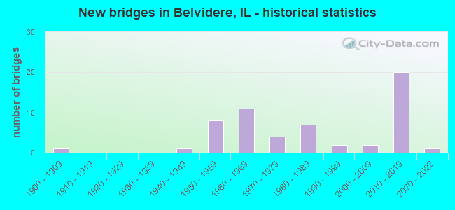
- New bridges - historical statistics
- 11900-1909
- 11940-1949
- 81950-1959
- 111960-1969
- 41970-1979
- 71980-1989
- 21990-1999
- 22000-2009
- 202010-2019
- 12020-2022
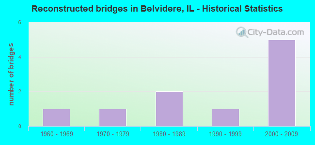
- Reconstructed bridges - Historical Statistics
- 11960-1969
- 11970-1979
- 21980-1989
- 11990-1999
- 52000-2009
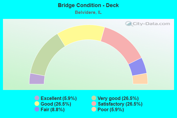
- Bridge Condition - Deck
- 5.9%Excellent
- 26.5%Very good
- 26.5%Good
- 26.5%Satisfactory
- 8.8%Fair
- 5.9%Poor
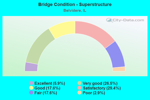
- Bridge Condition - Superstructure
- 5.9%Excellent
- 26.5%Very good
- 17.6%Good
- 29.4%Satisfactory
- 17.6%Fair
- 2.9%Poor
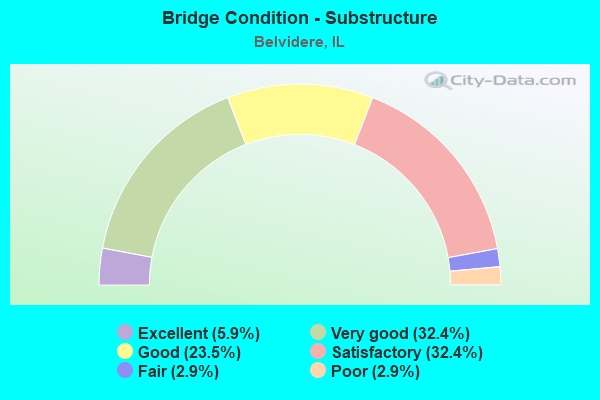
- Bridge Condition - Substructure
- 5.9%Excellent
- 32.4%Very good
- 23.5%Good
- 32.4%Satisfactory
- 2.9%Fair
- 2.9%Poor
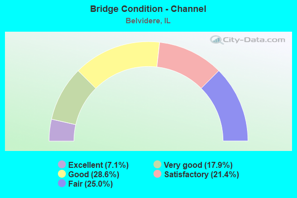
- Bridge Condition - Channel
- 7.1%Excellent
- 17.9%Very good
- 28.6%Good
- 21.4%Satisfactory
- 25.0%Fair
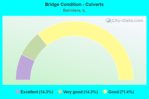
- Bridge Condition - Culverts
- 14.3%Excellent
- 14.3%Very good
- 71.4%Good
Find on map >> Show street view
Structure Number: 49965, Location: .5 MI S OF US 20 (Lat: 42.233778, Lng: -88.827117), Route carried "on" structure: City street , Year Built: 2016, Status: Open, Structure Length: 7.28m (23.88ft), Average Daily Traffic: 300 (year 2018), Average Future Daily Traffic: 95 (year 2032), Design Load: HS 25 or greater, Features Intersected: I-90, Facility Carried by Structure: TRIPP RD
Minimum Vertical Clearance: 30+ m (98+ ft), Kilometerpoint: 0.740, Lanes on structure: 2, Lanes under structure: 6, Owner: State Toll Authority, Approaching Roadway Width: 9.8m (32.2ft), Material/Design: Prestressed concrete continuous, Design/Construction: Stringer/Multi-beam, Length of Maximum Span: 36.9m (121.1ft), Curb-To-Curb Width: 9.8m (32.2ft), Out-to-Out Width: 10.8m (35.4ft)
Condition: Deck: Very good, Superstructure: Good, Substructure: Very good, Operating Rating: 52.5 metric tons, Method Used To Determine Operating Rating: Load and Resistance Factor Rating (LRFR) rating reported by rating factor(RF) method using HL-93 loadings, Inventory Rating: 37.3 metric tons, Method Used To Determine Inventory Rating: Load and Resistance Factor Rating (LRFR) rating reported by rating factor(RF) method using HL-93 loadings, Structural Evaluation: Better than present minimum criteria, Deck Geometry: Better than present minimum criteria, Underclear: Somewhat better than minimum adequacy, Approach Roadway Alignment: Equal to present desirable criteria, Designated Inspection Frequency: Every 24 months, Inspection Date: July 2020, Deck Structure Type: Concrete Cast-file-Place, Wearing Surface/Protective System: Deck Protection: Epoxy Coated Reinforcing
Find on map >> Show street view
Structure Number: 40004, Location: .11 MI E WHEELER RD (Lat: 42.239433, Lng: -88.917478), Route carried "under" structure: Interstate 90, Year Built: 1964, Structure Length: 0. m, Average Daily Traffic: 41,400 (year 2020), Truck Traffic: 29%, Features Intersected: I-90, Facility Carried by Structure: US 20 EB
Minimum Vertical Clearance: 4.93m (16.17ft), Kilometerpoint: 31.848, Lanes on structure: 2, Lanes under structure: 4, Material/Design: Steel continuous, Design/Construction: Stringer/Multi-beam, Length of Maximum Span: 28.7m (94.2ft)
Find on map >> Show street view
Structure Number: 40005, Location: SW EDGE BELVIDERE (Lat: 42.240261, Lng: -88.861319), Route carried "under" structure: Other road , Year Built: 1966, Structure Length: 0. m, Average Daily Traffic: 5,050 (year 2018), Truck Traffic: 13%, Features Intersected: S APPLETON RD, Facility Carried by Structure: US 20 EB
Minimum Vertical Clearance: 8.08m (26.51ft), Kilometerpoint: 3.524, Lanes on structure: 2, Lanes under structure: 4, Material/Design: Steel continuous, Design/Construction: Stringer/Multi-beam, Length of Maximum Span: 18.1m (59.4ft)
Find on map >> Show street view
Structure Number: 40006, Location: SW EDGE BELVIDERE (Lat: 42.240461, Lng: -88.861319), Route carried "under" structure: Other road , Year Built: 1966, Structure Length: 0. m, Average Daily Traffic: 5,050 (year 2018), Truck Traffic: 13%, Features Intersected: S APPLETON RD, Facility Carried by Structure: US 20 WB
Minimum Vertical Clearance: 8.23m (27.00ft), Kilometerpoint: 3.508, Lanes on structure: 3, Lanes under structure: 4, Material/Design: Steel continuous, Design/Construction: Stringer/Multi-beam, Length of Maximum Span: 16.5m (54.1ft)
Find on map >> Show street view
Structure Number: 40014, Location: E EDGE OF BELVIDERE (Lat: 42.260031, Lng: -88.822039), Route carried "under" structure: Business US 20, Year Built: 1986, Structure Length: 0. m, Average Daily Traffic: 12,100 (year 2021), Truck Traffic: 8%, Features Intersected: US 20 BR, Facility Carried by Structure: UP RR
Minimum Vertical Clearance: 4.98m (16.34ft), Kilometerpoint: 52.141, Lanes under structure: 2, Material/Design: Steel, Design/Construction: Girder and Floorbeam System, Length of Maximum Span: 33.6m (110.2ft)
Find on map >> Show street view
Structure Number: 40015, Location: NE OF BELVIDERE (Lat: 42.274522, Lng: -88.822536), Route carried "under" structure: Business US 20, Year Built: 1986, Structure Length: 0. m, Average Daily Traffic: 8,150 (year 2021), Truck Traffic: 12%, Features Intersected: US 20 BR, Facility Carried by Structure: POPLAR GROVE RD
Minimum Vertical Clearance: 5.26m (17.26ft), Kilometerpoint: 50.500, Lanes on structure: 2, Lanes under structure: 2, Material/Design: Steel continuous, Design/Construction: Stringer/Multi-beam, Length of Maximum Span: 37.1m (121.7ft)
Find on map >> Show street view
Structure Number: 499, Location: .13 MI E WHEELER RD (Lat: 42.239539, Lng: -88.917625), Route carried "under" structure: Interstate 90, Year Built: 1958, Structure Length: 0. m, Average Daily Traffic: 41,400 (year 2020), Truck Traffic: 29%, Features Intersected: I-90, Facility Carried by Structure: US 20 WB
Minimum Vertical Clearance: 4.62m (15.16ft), Kilometerpoint: 31.832, Lanes on structure: 2, Lanes under structure: 4, Material/Design: Steel continuous, Design/Construction: Stringer/Multi-beam, Length of Maximum Span: 28.7m (94.2ft)
Find on map >> Show street view
Structure Number: 4992, Location: 1 MI E WINN CO (Lat: 42.242156, Lng: -88.921567), Route carried "under" structure: Interstate 90, Year Built: 1958, Structure Length: 0. m, Average Daily Traffic: 41,400 (year 2020), Truck Traffic: 29%, Features Intersected: I-90, Facility Carried by Structure: UP RR
Minimum Vertical Clearance: 4.62m (15.16ft), Kilometerpoint: 31.397, Lanes under structure: 4, Material/Design: Steel, Design/Construction: Girder and Floorbeam System, Length of Maximum Span: 33.8m (110.9ft)
Find on map >> Show street view
Structure Number: 49921, Location: .6 MI S OF US 20 (Lat: 42.233650, Lng: -88.818361), Route carried "under" structure: Interstate 90, Year Built: 2014, Structure Length: 0. m, Average Daily Traffic: 44,800 (year 2020), Truck Traffic: 29%, Features Intersected: I 90, Facility Carried by Structure: GENOA RD- FAS 37
Minimum Vertical Clearance: 5.00m (16.40ft), Kilometerpoint: 40.249, Lanes on structure: 2, Lanes under structure: 4, Material/Design: Steel continuous, Design/Construction: Stringer/Multi-beam, Length of Maximum Span: 41.1m (134.8ft)
Find on map >> Show street view
Structure Number: 49922, Location: .5 MI S CHRYSLER DR (Lat: 42.233639, Lng: -88.788389), Route carried "under" structure: Interstate 90, Year Built: 2014, Structure Length: 0. m, Average Daily Traffic: 44,800 (year 2020), Truck Traffic: 29%, Features Intersected: I 90, Facility Carried by Structure: JOHNSON RD
Minimum Vertical Clearance: 5.00m (16.40ft), Kilometerpoint: 42.743, Lanes on structure: 2, Lanes under structure: 4, Material/Design: Concrete continuous, Design/Construction: Stringer/Multi-beam, Length of Maximum Span: 36.5m (119.8ft)
Find on map >> Show street view
Structure Number: 49954, Location: .5 MI S US 20 (Lat: 42.232997, Lng: -88.900625), Route carried "under" structure: Interstate 90, Year Built: 2013, Structure Length: 0. m, Average Daily Traffic: 40,300 (year 2020), Truck Traffic: 29%, Features Intersected: I 90, Facility Carried by Structure: IRENE RD
Minimum Vertical Clearance: 5.00m (16.40ft), Kilometerpoint: 33.473, Lanes on structure: 2, Lanes under structure: 4, Material/Design: Steel continuous, Design/Construction: Stringer/Multi-beam, Length of Maximum Span: 36.2m (118.8ft)
Find on map >> Show street view
Structure Number: 49956, Location: .5 MI S US 20 (Lat: 42.233289, Lng: -88.861211), Route carried "under" structure: Interstate 90, Year Built: 2013, Structure Length: 0. m, Average Daily Traffic: 40,300 (year 2020), Truck Traffic: 29%, Features Intersected: I 90, Facility Carried by Structure: STONE QUARRY RD
Minimum Vertical Clearance: 5.05m (16.57ft), Kilometerpoint: 36.724, Lanes on structure: 2, Lanes under structure: 4, Material/Design: Steel continuous, Design/Construction: Stringer/Multi-beam, Length of Maximum Span: 34.7m (113.8ft)
Find on map >> Show street view
Structure Number: 4996, Location: 2 MI E OF US 20 (Lat: 42.233125, Lng: -88.880847), Route carried "under" structure: Interstate 90, Year Built: 2014, Structure Length: 0. m, Average Daily Traffic: 40,300 (year 2020), Truck Traffic: 29%, Features Intersected: I 90, Facility Carried by Structure: TOWNHALL RD
Minimum Vertical Clearance: 5.00m (16.40ft), Kilometerpoint: 35.099, Lanes on structure: 2, Lanes under structure: 4, Material/Design: Concrete, Design/Construction: Stringer/Multi-beam, Length of Maximum Span: 36.3m (119.1ft)
Find on map >> Show street view
Structure Number: 49961, Location: 4 MI E OF US 20 (Lat: 42.233461, Lng: -88.841719), Route carried "under" structure: Interstate 90, Year Built: 2014, Structure Length: 0. m, Average Daily Traffic: 40,300 (year 2020), Truck Traffic: 29%, Features Intersected: I 90, Facility Carried by Structure: PEARL ST
Minimum Vertical Clearance: 5.05m (16.57ft), Kilometerpoint: 38.317, Lanes on structure: 2, Lanes under structure: 4, Material/Design: Prestressed concrete continuous, Design/Construction: Stringer/Multi-beam, Length of Maximum Span: 35.7m (117.1ft)
Find on map >> Show street view
Structure Number: 49964, Location: 3 MI W MCHENRY CO (Lat: 42.225089, Lng: -88.763967), Route carried "under" structure: Interstate 90, Year Built: 2016, Structure Length: 0. m, Average Daily Traffic: 44,800 (year 2020), Truck Traffic: 29%, Features Intersected: I 90, Facility Carried by Structure: SPRING CENTER RD
Minimum Vertical Clearance: 5.00m (16.40ft), Kilometerpoint: 44.980, Lanes on structure: 2, Lanes under structure: 6, Material/Design: Prestressed concrete continuous, Design/Construction: Stringer/Multi-beam, Length of Maximum Span: 40.5m (132.9ft)
Find on map >> Show street view
Structure Number: 49965, Location: .5 MI S OF US 20 (Lat: 42.233569, Lng: -88.827119), Route carried "under" structure: Interstate 90, Year Built: 2016, Structure Length: 0. m, Average Daily Traffic: 40,300 (year 2020), Truck Traffic: 29%, Features Intersected: I-90, Facility Carried by Structure: TRIPP RD
Minimum Vertical Clearance: 5.00m (16.40ft), Kilometerpoint: 39.541, Lanes on structure: 2, Lanes under structure: 6, Material/Design: Prestressed concrete continuous, Design/Construction: Stringer/Multi-beam, Length of Maximum Span: 36.9m (121.1ft)
Find on map >> Show street view
Structure Number: 49999, Location: 4.4 Mi E of US20 (Lat: 42.233508, Lng: -88.834717), Route carried "under" structure: Interstate 90, Year Built: 1960, Structure Length: 0. m, Average Daily Traffic: 40,300 (year 2020), Truck Traffic: 29%, Features Intersected: I-90, Facility Carried by Structure: Belvidere Oasis
Minimum Vertical Clearance: 4.75m (15.58ft), Kilometerpoint: 38.945, Lanes under structure: 8, Material/Design: Prestressed concrete continuous, Length of Maximum Span: 20.6m (67.6ft)