Bridge Statistics for Benton, Illinois (IL)
Condition, Traffic, Stress, Structural Evaluation, Project Costs
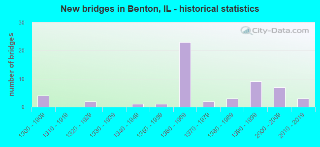
- New bridges - historical statistics
- 41900-1909
- 21920-1929
- 11940-1949
- 11950-1959
- 231960-1969
- 21970-1979
- 31980-1989
- 91990-1999
- 72000-2009
- 32010-2019
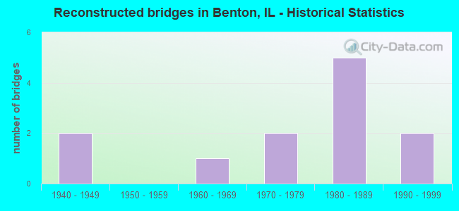
- Reconstructed bridges - Historical Statistics
- 21940-1949
- 01950-1959
- 11960-1969
- 21970-1979
- 51980-1989
- 21990-1999
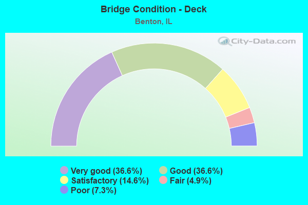
- Bridge Condition - Deck
- 36.6%Very good
- 36.6%Good
- 14.6%Satisfactory
- 4.9%Fair
- 7.3%Poor
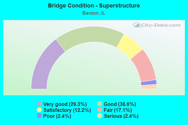
- Bridge Condition - Superstructure
- 29.3%Very good
- 36.6%Good
- 12.2%Satisfactory
- 17.1%Fair
- 2.4%Poor
- 2.4%Serious
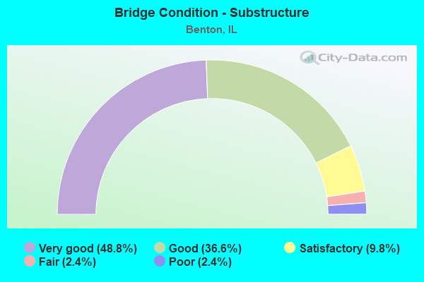
- Bridge Condition - Substructure
- 48.8%Very good
- 36.6%Good
- 9.8%Satisfactory
- 2.4%Fair
- 2.4%Poor
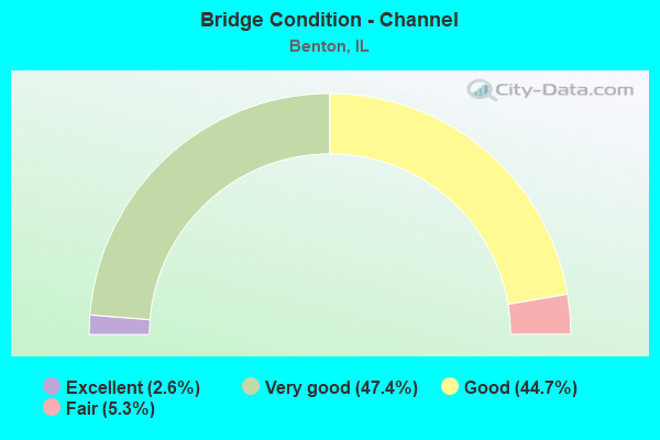
- Bridge Condition - Channel
- 2.6%Excellent
- 47.4%Very good
- 44.7%Good
- 5.3%Fair
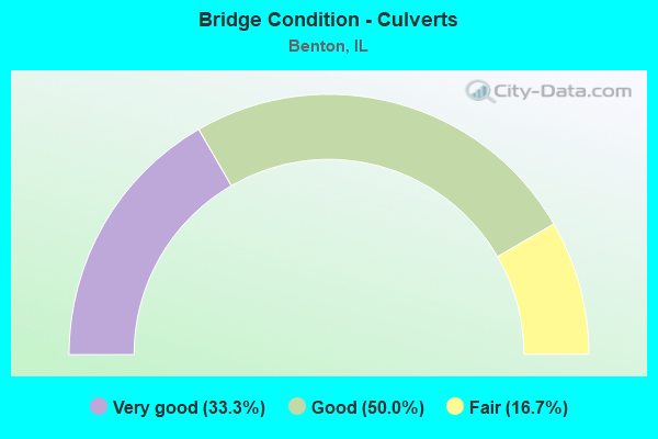
- Bridge Condition - Culverts
- 33.3%Very good
- 50.0%Good
- 16.7%Fair
Find on map >> Show street view
Structure Number: 283367, Location: 3 MI SE OF EWING (Lat: 38.044761, Lng: -88.877994), Route carried "on" structure: County highway , Year Built: 2002, Status: Open, Structure Length: 1.26m (4.13ft), Average Daily Traffic: 75 (year 2019), Truck Traffic: 28%, Average Future Daily Traffic: 106 (year 2032), Design Load: HS 20, Features Intersected: TRIB TO JORDAN CREEK, Facility Carried by Structure: TR 242-CYRILJAMES
Minimum Vertical Clearance: 30+ m (98+ ft), Kilometerpoint: 5.552, Lanes on structure: 2, Owner: Town or Township Highway Agency, Approaching Roadway Width: 7.3m (24.0ft), Material/Design: Prestressed concrete, Design/Construction: Box Beam or Girders - Multiple, Number Of Spans In Main Unit: 1, Length of Maximum Span: 11.9m (39.0ft), Curb-To-Curb Width: 7.3m (24.0ft), Out-to-Out Width: 7.3m (24.0ft)
Condition: Deck: Good, Superstructure: Very good, Substructure: Very good, Channel: Very good, Operating Rating: 44.1 metric tons, Method Used To Determine Operating Rating: Assigned rating based on Load Factor Design (LFD) reported by rating factor (RF) using MS18 loading, Inventory Rating: 32.4 metric tons, Method Used To Determine Inventory Rating: Assigned rating based on Load Factor Design (LFD) reported by rating factor (RF) using MS18 loading, Structural Evaluation: Equal to present desirable criteria, Deck Geometry: Equal to present minimum criteria, Waterway Adequacy: Superior to present desirable criteria, Approach Roadway Alignment: Superior to present desirable criteria, Designated Inspection Frequency: Every 48 months, Inspection Date: January 2020, Deck Structure Type: Concrete Precast Panels, Wearing Surface/Protective System: Wearing Surface: Gravel
Find on map >> Show street view
Structure Number: 283375, Location: SUGAR CREEK ROAD (Lat: 38.022028, Lng: -88.938683), Route carried "on" structure: County highway , Year Built: 2003, Status: Open, Structure Length: 1.36m (4.46ft), Average Daily Traffic: 125 (year 2019), Truck Traffic: 24%, Average Future Daily Traffic: 185 (year 2032), Design Load: HS 20, Features Intersected: SUGAR CREEK, Facility Carried by Structure: TR 194
Minimum Vertical Clearance: 30+ m (98+ ft), Kilometerpoint: 1.207, Lanes on structure: 2, Owner: Town or Township Highway Agency, Approaching Roadway Width: 6.1m (20.0ft), Material/Design: Prestressed concrete, Design/Construction: Box Beam or Girders - Multiple, Number Of Spans In Main Unit: 1, Length of Maximum Span: 12.8m (42.0ft), Curb-To-Curb Width: 7.3m (24.0ft), Out-to-Out Width: 7.3m (24.0ft)
Condition: Deck: Very good, Superstructure: Very good, Substructure: Very good, Channel: Excellent, Operating Rating: 44.1 metric tons, Method Used To Determine Operating Rating: Assigned rating based on Load Factor Design (LFD) reported by rating factor (RF) using MS18 loading, Inventory Rating: 32.4 metric tons, Method Used To Determine Inventory Rating: Assigned rating based on Load Factor Design (LFD) reported by rating factor (RF) using MS18 loading, Structural Evaluation: Equal to present desirable criteria, Deck Geometry: Somewhat better than minimum adequacy, Waterway Adequacy: Equal to present desirable criteria, Approach Roadway Alignment: Equal to present desirable criteria, Designated Inspection Frequency: Every 48 months, Inspection Date: July 2019, Deck Structure Type: Concrete Precast Panels, Wearing Surface/Protective System: Wearing Surface: Gravel
Find on map >> Show street view
Structure Number: 283376, Location: 1MI S.OF BENTON (Lat: 37.967403, Lng: -88.905239), Route carried "on" structure: County highway , Year Built: 2002, Status: Open, Structure Length: 0.96m (3.15ft), Average Daily Traffic: 1,050 (year 2019), Truck Traffic: 6%, Average Future Daily Traffic: 1,165 (year 2032), Design Load: HS 20+Mod, Features Intersected: TRIB-BIG MUDDY RIVER, Facility Carried by Structure: FAS 1878 S.MCLEANS
Minimum Vertical Clearance: 30+ m (98+ ft), Kilometerpoint: 1.609, Lanes on structure: 2, Owner: County Highway Agency, Approaching Roadway Width: 6.7m (22.0ft), Material/Design: Prestressed concrete, Design/Construction: Box Beam or Girders - Multiple, Number Of Spans In Main Unit: 1, Length of Maximum Span: 9.1m (29.9ft), Curb-To-Curb Width: 8.5m (27.9ft), Out-to-Out Width: 8.5m (27.9ft)
Condition: Deck: Good, Superstructure: Good, Substructure: Very good, Channel: Very good, Operating Rating: 41.8 metric tons, Method Used To Determine Operating Rating: Load Factor (LF) rating reported by rating factor (RF) method using MS18 loading, Inventory Rating: 24.9 metric tons, Method Used To Determine Inventory Rating: Load Factor (LF) rating reported by rating factor (RF) method using MS18 loading, Structural Evaluation: Equal to present minimum criteria, Deck Geometry: Somewhat better than minimum adequacy, Waterway Adequacy: Equal to present desirable criteria, Approach Roadway Alignment: Equal to present desirable criteria, Designated Inspection Frequency: Every 24 months, Inspection Date: March 2020, Deck Structure Type: Concrete Precast Panels, Wearing Surface/Protective System: Wearing Surface: Bituminous
Find on map >> Show street view
Structure Number: 283377, Location: S MCLEANSBORO ST (Lat: 37.981533, Lng: -88.910008), Route carried "on" structure: Other road , Year Built: 2003, Status: Open, Structure Length: 0.82m (2.69ft), Average Daily Traffic: 1,100 (year 2019), Truck Traffic: 7%, Average Future Daily Traffic: 1,165 (year 2032), Design Load: HS 20, Features Intersected: MID FK BIG MUDDY TRB, Facility Carried by Structure: FAU 9457 MCLEANSBO
Minimum Vertical Clearance: 30+ m (98+ ft), Kilometerpoint: 3.090, Lanes on structure: 2, Owner: Town or Township Highway Agency, Approaching Roadway Width: 6.7m (22.0ft), Skew: 3 degrees, Material/Design: Prestressed concrete, Design/Construction: Box Beam or Girders - Multiple, Number Of Spans In Main Unit: 1, Length of Maximum Span: 7.3m (24.0ft), Curb-To-Curb Width: 8.5m (27.9ft), Out-to-Out Width: 8.6m (28.2ft)
Condition: Deck: Very good, Superstructure: Very good, Substructure: Very good, Channel: Very good, Operating Rating: 53.8 metric tons, Method Used To Determine Operating Rating: Load Factor (LF) rating reported by rating factor (RF) method using MS18 loading, Inventory Rating: 32.4 metric tons, Method Used To Determine Inventory Rating: Load Factor (LF) rating reported by rating factor (RF) method using MS18 loading, Structural Evaluation: Equal to present desirable criteria, Deck Geometry: Somewhat better than minimum adequacy, Waterway Adequacy: Superior to present desirable criteria, Approach Roadway Alignment: Equal to present desirable criteria, Designated Inspection Frequency: Every 48 months, Inspection Date: July 2019, Deck Structure Type: Concrete Precast Panels, Wearing Surface/Protective System: Wearing Surface: Bituminous
Find on map >> Show street view
Structure Number: 283386, Location: SAM PYLE BRIDGE ROAD (Lat: 38.020736, Lng: -88.886097), Route carried "on" structure: County highway , Year Built: 2005, Status: Open, Structure Length: 1.27m (4.17ft), Average Daily Traffic: 550 (year 2019), Truck Traffic: 20%, Average Future Daily Traffic: 794 (year 2032), Design Load: HS 20, Features Intersected: LAKE MOSES, Facility Carried by Structure: TR 242
Minimum Vertical Clearance: 30+ m (98+ ft), Kilometerpoint: 8.851, Lanes on structure: 2, Owner: Town or Township Highway Agency, Approaching Roadway Width: 5.5m (18.0ft), Material/Design: Prestressed concrete, Design/Construction: Box Beam or Girders - Multiple, Number Of Spans In Main Unit: 1, Length of Maximum Span: 11.9m (39.0ft), Curb-To-Curb Width: 7.4m (24.3ft), Out-to-Out Width: 7.4m (24.3ft)
Condition: Deck: Good, Superstructure: Good, Substructure: Very good, Channel: Very good, Operating Rating: 44.1 metric tons, Method Used To Determine Operating Rating: Assigned rating based on Load Factor Design (LFD) reported by rating factor (RF) using MS18 loading, Inventory Rating: 32.4 metric tons, Method Used To Determine Inventory Rating: Assigned rating based on Load Factor Design (LFD) reported by rating factor (RF) using MS18 loading, Structural Evaluation: Better than present minimum criteria, Deck Geometry: Meets minimum limits, Waterway Adequacy: Equal to present desirable criteria, Approach Roadway Alignment: Equal to present desirable criteria, Designated Inspection Frequency: Every 48 months, Inspection Date: May 2020, Deck Structure Type: Concrete Precast Panels, Wearing Surface/Protective System: Wearing Surface: Gravel
Find on map >> Show street view
Structure Number: 286002, Location: CS 7080 (Lat: 38.054644, Lng: -88.909575), Route carried "on" structure: City street , Year Built: 1995, Status: Open, Structure Length: 2.26m (7.41ft), Average Daily Traffic: 150 (year 2014), Truck Traffic: 13%, Average Future Daily Traffic: 159 (year 2032), Design Load: HS 20, Features Intersected: BENTON LAKE, Facility Carried by Structure: CS 7080
Minimum Vertical Clearance: 30+ m (98+ ft), Kilometerpoint: 1.464, Lanes on structure: 2, Owner: City or Municipal Highway Agency, Approaching Roadway Width: 6.1m (20.0ft), Material/Design: Prestressed concrete, Design/Construction: Box Beam or Girders - Multiple, Number Of Spans In Main Unit: 1, Length of Maximum Span: 21.6m (70.9ft), Curb-To-Curb Width: 9.2m (30.2ft), Out-to-Out Width: 9.2m (30.2ft)
Condition: Deck: Very good, Superstructure: Very good, Substructure: Very good, Channel: Very good, Operating Rating: 44.1 metric tons, Method Used To Determine Operating Rating: Assigned rating based on Load Factor Design (LFD) reported by rating factor (RF) using MS18 loading, Inventory Rating: 32.4 metric tons, Method Used To Determine Inventory Rating: Assigned rating based on Load Factor Design (LFD) reported by rating factor (RF) using MS18 loading, Structural Evaluation: Equal to present desirable criteria, Deck Geometry: Equal to present minimum criteria, Waterway Adequacy: Equal to present desirable criteria, Approach Roadway Alignment: Equal to present desirable criteria, Designated Inspection Frequency: Every 48 months, Inspection Date: July 2018, Deck Structure Type: Concrete Precast Panels, Wearing Surface/Protective System: Wearing Surface: Gravel
Find on map >> Show street view
Structure Number: 286004, Location: MIRROR LAKE SUBDVSN (Lat: 38.002500, Lng: -88.896411), Route carried "on" structure: Other road , Year Built: 1997, Status: Open, Structure Length: 1.58m (5.18ft), Average Daily Traffic: 200 (year 2019), Truck Traffic: 11%, Average Future Daily Traffic: 26 (year 2032), Design Load: HS 20, Features Intersected: TRIB OF BIG MUDDY RV, Facility Carried by Structure: E TAYLOR STREET
Minimum Vertical Clearance: 30+ m (98+ ft), Kilometerpoint: 0.145, Lanes on structure: 2, Owner: City or Municipal Highway Agency, Approaching Roadway Width: 6.1m (20.0ft), Skew: 1 degrees, Material/Design: Prestressed concrete, Design/Construction: Box Beam or Girders - Multiple, Number Of Spans In Main Unit: 1, Length of Maximum Span: 15.0m (49.2ft), Curb-To-Curb Width: 8.7m (28.5ft), Out-to-Out Width: 8.7m (28.5ft)
Condition: Deck: Very good, Superstructure: Good, Substructure: Very good, Channel: Very good, Operating Rating: 44.1 metric tons, Method Used To Determine Operating Rating: Assigned rating based on Load Factor Design (LFD) reported by rating factor (RF) using MS18 loading, Inventory Rating: 32.4 metric tons, Method Used To Determine Inventory Rating: Assigned rating based on Load Factor Design (LFD) reported by rating factor (RF) using MS18 loading, Structural Evaluation: Better than present minimum criteria, Deck Geometry: Equal to present minimum criteria, Waterway Adequacy: Equal to present desirable criteria, Approach Roadway Alignment: Equal to present desirable criteria, Designated Inspection Frequency: Every 48 months, Inspection Date: July 2018, Deck Structure Type: Concrete Precast Panels, Wearing Surface/Protective System: Wearing Surface: Gravel
Find on map >> Show street view
Structure Number: CEPLMSIL-000003, Location: REND LAKE (Lat: 38.037831, Lng: -88.956417), Route carried "on" structure: ServiceOther road , Year Built: 1971, Status: Posted for load, Structure Length: 18.44m (60.50ft), Average Daily Traffic: 2,180 (year 2014), Truck Traffic: 5%, Average Future Daily Traffic: 2,000 (year 2037), Design Load: HL 93, Features Intersected: REND LAKE SPILLWAY, Facility Carried by Structure: REND LAKE DAM RD.
Minimum Vertical Clearance: 30+ m (98+ ft), Kilometerpoint: 0.000, Lanes on structure: 2, Owner: Corps of Engineers (Civil), Approaching Roadway Width: 7.3m (24.0ft), Material/Design: Steel continuous, Design/Construction: Stringer/Multi-beam, Number Of Spans In Main Unit: 6, Length of Maximum Span: 30.5m (100.1ft), Curb or Sidewalk Widths: Left: 0.9m (3.0ft), Right: 0.9m (3.0ft), Curb-To-Curb Width: 7.3m (24.0ft), Out-to-Out Width: 9.1m (29.9ft)
Condition: Deck: Good, Superstructure: Good, Substructure: Good, Channel: Good, Operating Rating: 39.5 metric tons, Method Used To Determine Operating Rating: Load and Resistance Factor Rating (LRFR) rating reported by rating factor(RF) method using HL-93 loadings, Inventory Rating: 30.5 metric tons, Method Used To Determine Inventory Rating: Load and Resistance Factor Rating (LRFR) rating reported by rating factor(RF) method using HL-93 loadings, Structural Evaluation: Better than present minimum criteria, Deck Geometry: High priority of replacement, Waterway Adequacy: Equal to present desirable criteria, Approach Roadway Alignment: Equal to present desirable criteria, Designated Inspection Frequency: Every 24 months, Underwater Inspection Frequency: Every 60 months, Inspection Date: May 2020, Underwater Inspection Date: May 2020, Bridge Improvement Cost: $52,000, Total Project Cost: $52,000 ( Estimate for 2020), Deck Structure Type: Concrete Cast-file-Place
Find on map >> Show street view
Structure Number: 280053, Location: 2.1 MI. S ILL 154 (Lat: 38.052456, Lng: -88.924419), Route carried "under" structure: Interstate 57, Year Built: 1962, Structure Length: 0. m, Average Daily Traffic: 38,900 (year 2021), Truck Traffic: 41%, Features Intersected: FAI RTE 57, Facility Carried by Structure: CH 19 (MARCUM BR)
Minimum Vertical Clearance: 4.95m (16.24ft), Kilometerpoint: 121.486, Lanes on structure: 2, Lanes under structure: 4, Material/Design: Steel continuous, Design/Construction: Stringer/Multi-beam, Length of Maximum Span: 20.5m (67.3ft)
Find on map >> Show street view
Structure Number: 280054, Location: 4.8 MI N ILL 149 (Lat: 37.964911, Lng: -88.935400), Route carried "under" structure: Interstate 57, Year Built: 1962, Structure Length: 0. m, Average Daily Traffic: 40,000 (year 2021), Truck Traffic: 39%, Features Intersected: FAI RTE 57, Facility Carried by Structure: TR 241(FOREST BAPT
Minimum Vertical Clearance: 5.08m (16.67ft), Kilometerpoint: 111.637, Lanes on structure: 2, Lanes under structure: 4, Material/Design: Steel continuous, Design/Construction: Stringer/Multi-beam, Length of Maximum Span: 18.3m (60.0ft)
Find on map >> Show street view
Structure Number: 280056, Location: 1 MI S IL 154 (Lat: 38.067172, Lng: -88.923331), Route carried "under" structure: Interstate 57, Year Built: 1961, Structure Length: 0. m, Average Daily Traffic: 38,900 (year 2021), Truck Traffic: 41%, Features Intersected: FAI RTE 57, Facility Carried by Structure: TR 75 (FRANKLIN CE
Minimum Vertical Clearance: 5.16m (16.93ft), Kilometerpoint: 123.128, Lanes on structure: 2, Lanes under structure: 4, Material/Design: Steel continuous, Design/Construction: Stringer/Multi-beam, Length of Maximum Span: 21.2m (69.6ft)
Find on map >> Show street view
Structure Number: 280057, Location: 1.4 MI. N ILL 14 (Lat: 38.016139, Lng: -88.925769), Route carried "under" structure: Interstate 57, Year Built: 1963, Structure Length: 0. m, Average Daily Traffic: 38,900 (year 2021), Truck Traffic: 41%, Features Intersected: FAI RTE 57, Facility Carried by Structure: FAU 9441-PETROFF R
Minimum Vertical Clearance: 5.08m (16.67ft), Kilometerpoint: 117.463, Lanes on structure: 2, Lanes under structure: 4, Material/Design: Steel continuous, Design/Construction: Stringer/Multi-beam, Length of Maximum Span: 20.5m (67.3ft)
Find on map >> Show street view
Structure Number: 280059, Location: 3.2 MI. S JEFF. CO. (Lat: 38.080369, Lng: -88.915750), Route carried "under" structure: Interstate 57, Year Built: 1962, Structure Length: 0. m, Average Daily Traffic: 38,500 (year 2021), Truck Traffic: 42%, Features Intersected: FAI RTE 57, Facility Carried by Structure: ILL 154
Minimum Vertical Clearance: 5.00m (16.40ft), Kilometerpoint: 124.753, Lanes on structure: 2, Lanes under structure: 4, Material/Design: Steel continuous, Design/Construction: Stringer/Multi-beam, Length of Maximum Span: 20.5m (67.3ft)
Find on map >> Show street view
Structure Number: 280064, Location: NEAR NCL BENTON (Lat: 38.008419, Lng: -88.928436), Route carried "under" structure: Interstate 57, Year Built: 1963, Structure Length: 0. m, Average Daily Traffic: 38,900 (year 2021), Truck Traffic: 41%, Features Intersected: INTERSTATE 57, Facility Carried by Structure: DUQUOIN ST - BENTO
Minimum Vertical Clearance: 5.21m (17.09ft), Kilometerpoint: 116.578, Lanes on structure: 2, Lanes under structure: 4, Material/Design: Steel continuous, Design/Construction: Stringer/Multi-beam, Length of Maximum Span: 26.0m (85.3ft)
Find on map >> Show street view
Structure Number: 282, Location: 1 MI S WEST CITY (Lat: 37.979500, Lng: -88.935319), Route carried "under" structure: County highway , Year Built: 1962, Structure Length: 0. m, Average Daily Traffic: 200 (year 2019), Truck Traffic: 31%, Features Intersected: TR 213 LINN RD, Facility Carried by Structure: I 57
Minimum Vertical Clearance: 4.09m (13.42ft), Kilometerpoint: 1.368, Lanes on structure: 4, Lanes under structure: 2, Material/Design: Concrete, Design/Construction: Culvert, Length of Maximum Span: 7.3m (24.0ft)
Find on map >> Show street view
Structure Number: 28993, Location: SOUTH OF IL 14 (Lat: 37.991983, Lng: -88.928989), Route carried "under" structure: Other road , Year Built: 1900, Structure Length: 0. m, Average Daily Traffic: 1,700 (year 2019), Truck Traffic: 8%, Features Intersected: DUQUOIN ST IN BENTON, Facility Carried by Structure: ICG RR
Minimum Vertical Clearance: 2.34m (7.68ft), Kilometerpoint: 2.688, Lanes under structure: 2, Material/Design: Steel, Design/Construction: Stringer/Multi-beam, Length of Maximum Span: 5.8m (19.0ft)