Bridge Statistics for Bethlehem, Pennsylvania (PA)
Condition, Traffic, Stress, Structural Evaluation, Project Costs
- National Bridge Inventory (NBI) Statistics
- 130Number of bridges
- 1,890ft / 576mTotal length
- $31,624,000Total costs
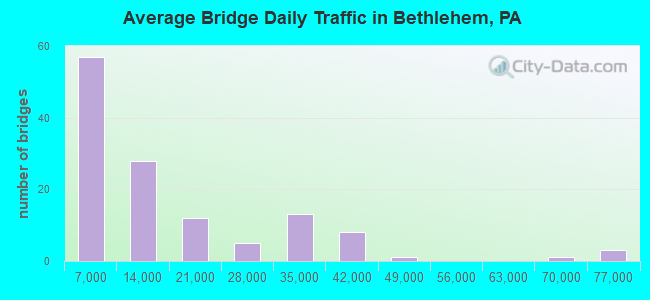
- 1,766,022Total average daily traffic
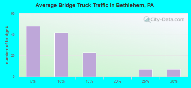
- 195,398Total average daily truck traffic
- National Bridge Inventory (NBI) Registered Bridges for Bethlehem
- No street view available for this location
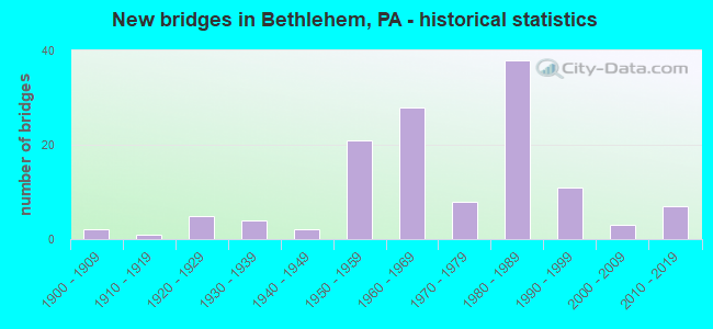
- New bridges - historical statistics
- 21900-1909
- 11910-1919
- 51920-1929
- 41930-1939
- 21940-1949
- 211950-1959
- 281960-1969
- 81970-1979
- 381980-1989
- 111990-1999
- 32000-2009
- 72010-2019
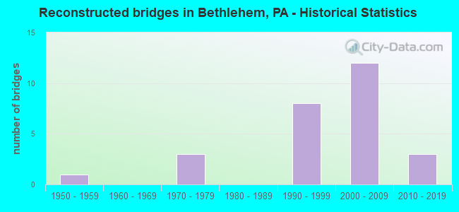
- Reconstructed bridges - Historical Statistics
- 11950-1959
- 01960-1969
- 31970-1979
- 01980-1989
- 81990-1999
- 122000-2009
- 32010-2019
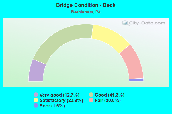
- Bridge Condition - Deck
- 12.7%Very good
- 41.3%Good
- 23.8%Satisfactory
- 20.6%Fair
- 1.6%Poor
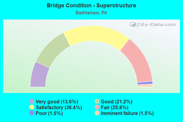
- Bridge Condition - Superstructure
- 13.6%Very good
- 21.2%Good
- 36.4%Satisfactory
- 25.8%Fair
- 1.5%Poor
- 1.5%Imminent failure
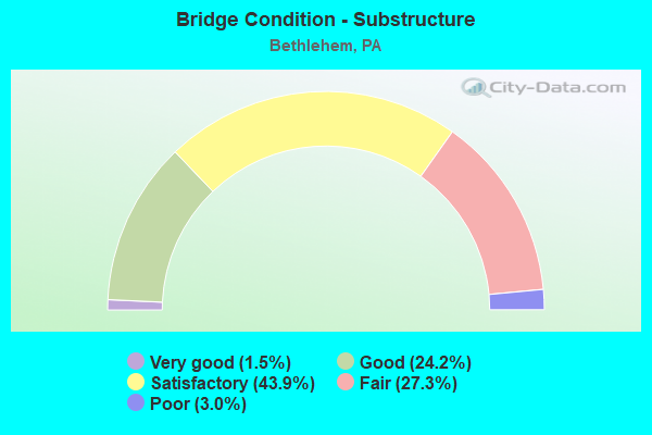
- Bridge Condition - Substructure
- 1.5%Very good
- 24.2%Good
- 43.9%Satisfactory
- 27.3%Fair
- 3.0%Poor
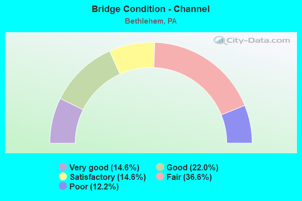
- Bridge Condition - Channel
- 14.6%Very good
- 22.0%Good
- 14.6%Satisfactory
- 36.6%Fair
- 12.2%Poor
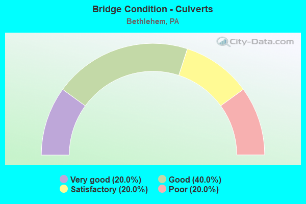
- Bridge Condition - Culverts
- 20.0%Very good
- 40.0%Good
- 20.0%Satisfactory
- 20.0%Poor
Find on map >> Show street view
Structure Number: 23192, Location: PA 378 UNDER EATON AVE. (Lat: 40.631456, Lng: -75.408458), Route carried "under" structure: State highway 378, Year Built: 1967, Structure Length: 0. m, Average Daily Traffic: 14,435 (year 2020), Truck Traffic: 6%, Features Intersected: PA 378(LR1007),RC DITCH, Facility Carried by Structure: SR1018(EATON AVE.)
Minimum Vertical Clearance: 4.96m (16.27ft), Kilometerpoint: 8.085, Lanes on structure: 2, Lanes under structure: 4, Material/Design: Prestressed concrete, Design/Construction: Box Beam or Girders - Single/Spread, Length of Maximum Span: 18.6m (61.0ft)
Find on map >> Show street view
Structure Number: 23192, Location: PA 378 UNDER EATON AVE. (Lat: 40.631456, Lng: -75.408458), Route carried "under" structure: State highway 378, Year Built: 1967, Structure Length: 0. m, Average Daily Traffic: 13,152 (year 2020), Truck Traffic: 5%, Features Intersected: PA 378(LR1007),RC DITCH, Facility Carried by Structure: SR1018(EATON AVE.)
Minimum Vertical Clearance: 4.55m (14.93ft), Kilometerpoint: 8.024, Lanes on structure: 2, Lanes under structure: 4, Material/Design: Prestressed concrete, Design/Construction: Box Beam or Girders - Single/Spread, Length of Maximum Span: 18.6m (61.0ft)
Find on map >> Show street view
Structure Number: 23196, Location: CATASAUQUA RD.OVER 378 (Lat: 40.639747, Lng: -75.409711), Route carried "under" structure: State highway 378, Year Built: 1967, Structure Length: 0. m, Average Daily Traffic: 14,435 (year 2020), Truck Traffic: 6%, Features Intersected: PA 378(LR1007), Facility Carried by Structure: SR1020CATASAUQUARD
Minimum Vertical Clearance: 4.57m (14.99ft), Kilometerpoint: 8.903, Lanes on structure: 2, Lanes under structure: 4, Material/Design: Prestressed concrete, Design/Construction: Box Beam or Girders - Single/Spread, Length of Maximum Span: 23.8m (78.1ft)
Find on map >> Show street view
Structure Number: 23196, Location: CATASAUQUA RD.OVER 378 (Lat: 40.639747, Lng: -75.409711), Route carried "under" structure: State highway 378, Year Built: 1967, Structure Length: 0. m, Average Daily Traffic: 13,152 (year 2020), Truck Traffic: 5%, Features Intersected: PA 378(LR1007), Facility Carried by Structure: SR1020CATASAUQUARD
Minimum Vertical Clearance: 4.36m (14.30ft), Kilometerpoint: 8.842, Lanes on structure: 2, Lanes under structure: 4, Material/Design: Prestressed concrete, Design/Construction: Box Beam or Girders - Single/Spread, Length of Maximum Span: 23.8m (78.1ft)
Find on map >> Show street view
Structure Number: 23208, Location: AIRPORT RD.INTERCHANGE (Lat: 40.643153, Lng: -75.431833), Route carried "under" structure: US 22, Year Built: 1973, Structure Length: 0. m, Average Daily Traffic: 41,371 (year 2022), Truck Traffic: 9%, Features Intersected: US 22(LR 771), Facility Carried by Structure: PA 987 (LR 39031)
Minimum Vertical Clearance: 4.82m (15.81ft), Kilometerpoint: 15.055, Lanes on structure: 4, Lanes under structure: 4, Material/Design: Steel, Design/Construction: Stringer/Multi-beam, Length of Maximum Span: 62.5m (205.1ft)
Find on map >> Show street view
Structure Number: 23208, Location: AIRPORT RD.INTERCHANGE (Lat: 40.643153, Lng: -75.431833), Route carried "under" structure: US 22, Year Built: 1973, Structure Length: 0. m, Average Daily Traffic: 42,501 (year 2022), Truck Traffic: 7%, Features Intersected: US 22(LR 771), Facility Carried by Structure: PA 987 (LR 39031)
Minimum Vertical Clearance: 4.82m (15.81ft), Kilometerpoint: 15.617, Lanes on structure: 4, Lanes under structure: 4, Material/Design: Steel, Design/Construction: Stringer/Multi-beam, Length of Maximum Span: 62.5m (205.1ft)
Find on map >> Show street view
Structure Number: 23233, Location: 8TH AVE.EXIT (Lat: 40.628300, Lng: -75.394808), Route carried "under" structure: State highway 378, Year Built: 1967, Structure Length: 0. m, Average Daily Traffic: 14,435 (year 2020), Truck Traffic: 6%, Features Intersected: PA 378(LR 1007), Facility Carried by Structure: SR 1011(LR 48129)
Minimum Vertical Clearance: 4.48m (14.70ft), Kilometerpoint: 6.814, Lanes on structure: 4, Lanes under structure: 4, Material/Design: Prestressed concrete, Design/Construction: Box Beam or Girders - Single/Spread, Length of Maximum Span: 21.9m (71.9ft)
Find on map >> Show street view
Structure Number: 23233, Location: 8TH AVE.EXIT (Lat: 40.628300, Lng: -75.394808), Route carried "under" structure: State highway 378, Year Built: 1967, Structure Length: 0. m, Average Daily Traffic: 13,152 (year 2020), Truck Traffic: 5%, Features Intersected: PA 378(LR 1007), Facility Carried by Structure: SR 1011(LR 48129)
Minimum Vertical Clearance: 4.51m (14.80ft), Kilometerpoint: 6.429, Lanes on structure: 4, Lanes under structure: 4, Material/Design: Prestressed concrete, Design/Construction: Box Beam or Girders - Single/Spread, Length of Maximum Span: 21.9m (71.9ft)
Find on map >> Show street view
Structure Number: 28471, Location: 1 MI.W.OF PA.512 (Lat: 40.656125, Lng: -75.397719), Route carried "under" structure: City street , Year Built: 1954, Structure Length: 0. m, Average Daily Traffic: 1,800 (year 1994), Truck Traffic: 1%, Features Intersected: T-575(JACKSONVILLE ROAD), Facility Carried by Structure: US 22 (LR 772)
Minimum Vertical Clearance: 4.23m (13.88ft), Kilometerpoint: 0.000, Lanes on structure: 4, Lanes under structure: 2, Material/Design: Concrete, Design/Construction: Tee Beam, Length of Maximum Span: 14.0m (45.9ft)
Find on map >> Show street view
Structure Number: 28473, Location: PA 512 INTERCHANGE (Lat: 40.662772, Lng: -75.383964), Route carried "under" structure: State highway , Year Built: 1954, Structure Length: 0. m, Average Daily Traffic: 8,931 (year 2020), Truck Traffic: 6%, Features Intersected: PA 512(LR 48046), Facility Carried by Structure: US 22 (LR 772)
Minimum Vertical Clearance: 4.88m (16.01ft), Kilometerpoint: 5.560, Lanes on structure: 4, Lanes under structure: 1, Material/Design: Steel, Design/Construction: Stringer/Multi-beam, Length of Maximum Span: 19.8m (65.0ft)
Find on map >> Show street view
Structure Number: 28473, Location: PA 512 INTERCHANGE (Lat: 40.662772, Lng: -75.383964), Route carried "under" structure: State highway 512, Year Built: 1954, Structure Length: 0. m, Average Daily Traffic: 13,505 (year 2022), Truck Traffic: 10%, Features Intersected: PA 512(LR 48046), Facility Carried by Structure: US 22 (LR 772)
Minimum Vertical Clearance: 4.48m (14.70ft), Kilometerpoint: 0.000, Lanes on structure: 4, Lanes under structure: 4, Material/Design: Steel, Design/Construction: Stringer/Multi-beam, Length of Maximum Span: 19.8m (65.0ft)
Find on map >> Show street view
Structure Number: 28473, Location: PA 512 INTERCHANGE (Lat: 40.662772, Lng: -75.383964), Route carried "under" structure: State highway 512, Year Built: 1954, Structure Length: 0. m, Average Daily Traffic: 12,510 (year 2022), Truck Traffic: 12%, Features Intersected: PA 512(LR 48046), Facility Carried by Structure: US 22 (LR 772)
Minimum Vertical Clearance: 4.88m (16.01ft), Kilometerpoint: 0.000, Lanes on structure: 4, Lanes under structure: 4, Material/Design: Steel, Design/Construction: Stringer/Multi-beam, Length of Maximum Span: 19.8m (65.0ft)
Find on map >> Show street view
Structure Number: 28473, Location: PA 512 INTERCHANGE (Lat: 40.662772, Lng: -75.383964), Route carried "under" structure: State highway , Year Built: 1954, Structure Length: 0. m, Average Daily Traffic: 8,590 (year 2020), Truck Traffic: 5%, Features Intersected: PA 512(LR 48046), Facility Carried by Structure: US 22 (LR 772)
Minimum Vertical Clearance: 4.48m (14.70ft), Kilometerpoint: 5.560, Lanes on structure: 4, Lanes under structure: 1, Material/Design: Steel, Design/Construction: Stringer/Multi-beam, Length of Maximum Span: 19.8m (65.0ft)
Find on map >> Show street view
Structure Number: 28474, Location: US 22 OVER T-434 (Lat: 40.671550, Lng: -75.365769), Route carried "under" structure: City street , Year Built: 1954, Structure Length: 0. m, Average Daily Traffic: 750 (year 1994), Truck Traffic: 1%, Features Intersected: TWP.LINE RD.(T-434), Facility Carried by Structure: US 22 (LR 772)
Minimum Vertical Clearance: 4.42m (14.50ft), Kilometerpoint: 0.000, Lanes on structure: 4, Lanes under structure: 2, Material/Design: Concrete, Design/Construction: Tee Beam, Length of Maximum Span: 11.3m (37.1ft)
Find on map >> Show street view
Structure Number: 28475, Location: OVER CHRISTIAN SPRINGS RD (Lat: 40.677333, Lng: -75.349539), Route carried "under" structure: City street , Year Built: 1954, Structure Length: 0. m, Average Daily Traffic: 300 (year 1994), Truck Traffic: 1%, Features Intersected: CHRISTIAN SPRING RD., Facility Carried by Structure: US 22 (LR 772)
Minimum Vertical Clearance: 4.27m (14.01ft), Kilometerpoint: 0.000, Lanes on structure: 4, Lanes under structure: 2, Material/Design: Concrete, Design/Construction: Tee Beam, Length of Maximum Span: 11.3m (37.1ft)
Find on map >> Show street view
Structure Number: 28477, Location: PA 191 INTERCHANGE (Lat: 40.678364, Lng: -75.342564), Route carried "under" structure: State highway 191, Year Built: 1954, Structure Length: 0. m, Average Daily Traffic: 6,804 (year 2022), Truck Traffic: 6%, Features Intersected: PA 191 & MONOCACY CR., Facility Carried by Structure: US 22 (LR 772)
Minimum Vertical Clearance: 6.19m (20.31ft), Kilometerpoint: 0.000, Lanes on structure: 4, Lanes under structure: 4, Material/Design: Steel continuous, Design/Construction: Stringer/Multi-beam, Length of Maximum Span: 26.8m (87.9ft)
Find on map >> Show street view
Structure Number: 28477, Location: PA 191 INTERCHANGE (Lat: 40.678364, Lng: -75.342564), Route carried "under" structure: State highway 191, Year Built: 1954, Structure Length: 0. m, Average Daily Traffic: 6,804 (year 2022), Truck Traffic: 6%, Features Intersected: PA 191 & MONOCACY CR., Facility Carried by Structure: US 22 (LR 772)
Minimum Vertical Clearance: 6.04m (19.82ft), Kilometerpoint: 0.000, Lanes on structure: 4, Lanes under structure: 4, Material/Design: Steel continuous, Design/Construction: Stringer/Multi-beam, Length of Maximum Span: 26.8m (87.9ft)
Find on map >> Show street view
Structure Number: 28477, Location: PA 191 INTERCHANGE (Lat: 40.678364, Lng: -75.342564), Route carried "under" structure: State highway , Year Built: 1954, Structure Length: 0. m, Average Daily Traffic: 9,201 (year 2022), Truck Traffic: 3%, Features Intersected: PA 191 & MONOCACY CR., Facility Carried by Structure: US 22 (LR 772)
Minimum Vertical Clearance: 30+ m (98+ ft), Kilometerpoint: 5.172, Lanes on structure: 4, Lanes under structure: 4, Material/Design: Steel continuous, Design/Construction: Stringer/Multi-beam, Length of Maximum Span: 26.8m (87.9ft)
Find on map >> Show street view
Structure Number: 28528, Location: I-78 OVER SO.MT. DRIVE (Lat: 40.590919, Lng: -75.368458), Route carried "under" structure: City street , Year Built: 1988, Structure Length: 0. m, Average Daily Traffic: 200 (year 1992), Truck Traffic: 1%, Features Intersected: SO.MT.DRIVE(T-422), Facility Carried by Structure: I- 78EB(LR 1045)
Minimum Vertical Clearance: 7.21m (23.65ft), Kilometerpoint: 0.000, Lanes on structure: 2, Lanes under structure: 2, Material/Design: Prestressed concrete, Design/Construction: Box Beam or Girders - Single/Spread, Length of Maximum Span: 17.7m (58.1ft)
Find on map >> Show street view
Structure Number: 28529, Location: I-78 OVER SO.MT.DRIVE (Lat: 40.591203, Lng: -75.368578), Route carried "under" structure: City street , Year Built: 1988, Structure Length: 0. m, Average Daily Traffic: 200 (year 1992), Truck Traffic: 1%, Features Intersected: SO.MT.DRIVE(T-422), Facility Carried by Structure: I-78 WB (LR 1045)
Minimum Vertical Clearance: 4.59m (15.06ft), Kilometerpoint: 0.000, Lanes on structure: 2, Lanes under structure: 2, Material/Design: Prestressed concrete, Design/Construction: Box Beam or Girders - Single/Spread, Length of Maximum Span: 17.7m (58.1ft)
Find on map >> Show street view
Structure Number: 2853, Location: I78 EB OVER WILLIAMS ST. (Lat: 40.595858, Lng: -75.350350), Route carried "under" structure: City street , Year Built: 1988, Structure Length: 0. m, Average Daily Traffic: 200 (year 1992), Truck Traffic: 1%, Features Intersected: WILLIAMS STREET, Facility Carried by Structure: I-78EB(LR 1045)
Minimum Vertical Clearance: 5.70m (18.70ft), Kilometerpoint: 0.000, Lanes on structure: 2, Lanes under structure: 2, Material/Design: Prestressed concrete, Design/Construction: Stringer/Multi-beam, Length of Maximum Span: 31.4m (103.0ft)
Find on map >> Show street view
Structure Number: 28531, Location: SAUCON PARK VIADUCT (Lat: 40.595861, Lng: -75.350419), Route carried "under" structure: City street , Year Built: 1988, Structure Length: 0. m, Average Daily Traffic: 200 (year 1992), Truck Traffic: 10%, Features Intersected: CREEK,STREETS,P.B.& N. E, Facility Carried by Structure: I-78 EB (LR 1045)
Minimum Vertical Clearance: 12.25m (40.19ft), Kilometerpoint: 0.000, Lanes on structure: 2, Lanes under structure: 6, Material/Design: Steel continuous, Design/Construction: Stringer/Multi-beam, Length of Maximum Span: 66.4m (217.8ft)
Find on map >> Show street view
Structure Number: 28531, Location: SAUCON PARK VIADUCT (Lat: 40.595861, Lng: -75.350419), Route carried "under" structure: City street , Year Built: 1988, Structure Length: 0. m, Average Daily Traffic: 200 (year 1992), Truck Traffic: 10%, Features Intersected: CREEK,STREETS,P.B.& N. E, Facility Carried by Structure: I-78 EB (LR 1045)
Minimum Vertical Clearance: 12.68m (41.60ft), Kilometerpoint: 0.000, Lanes on structure: 2, Lanes under structure: 6, Material/Design: Steel continuous, Design/Construction: Stringer/Multi-beam, Length of Maximum Span: 66.4m (217.8ft)
Find on map >> Show street view
Structure Number: 28531, Location: SAUCON PARK VIADUCT (Lat: 40.595861, Lng: -75.350419), Route carried "under" structure: City street , Year Built: 1988, Structure Length: 0. m, Average Daily Traffic: 200 (year 1992), Truck Traffic: 10%, Features Intersected: CREEK,STREETS,P.B.& N. E, Facility Carried by Structure: I-78 EB (LR 1045)
Minimum Vertical Clearance: 11.22m (36.81ft), Kilometerpoint: 0.000, Lanes on structure: 2, Lanes under structure: 6, Material/Design: Steel continuous, Design/Construction: Stringer/Multi-beam, Length of Maximum Span: 66.4m (217.8ft)
Find on map >> Show street view
Structure Number: 28532, Location: EXIT 21(67)PA.412 (Lat: 40.596228, Lng: -75.340389), Route carried "under" structure: State highway 412, Year Built: 1988, Structure Length: 0. m, Average Daily Traffic: 12,333 (year 2021), Truck Traffic: 10%, Features Intersected: PA 412(LR 530)& RAMP, Facility Carried by Structure: I-78EB(LR 1045)
Minimum Vertical Clearance: 5.09m (16.70ft), Kilometerpoint: 6.666, Lanes on structure: 2, Lanes under structure: 2, Material/Design: Prestressed concrete, Design/Construction: Stringer/Multi-beam, Length of Maximum Span: 24.7m (81.0ft)
Find on map >> Show street view
Structure Number: 28532, Location: EXIT 21(67)PA.412 (Lat: 40.596228, Lng: -75.340389), Route carried "under" structure: State highway 412, Year Built: 1988, Structure Length: 0. m, Average Daily Traffic: 12,268 (year 2021), Truck Traffic: 9%, Features Intersected: PA 412(LR 530)& RAMP, Facility Carried by Structure: I-78EB(LR 1045)
Minimum Vertical Clearance: 5.21m (17.09ft), Kilometerpoint: 6.666, Lanes on structure: 2, Lanes under structure: 3, Material/Design: Prestressed concrete, Design/Construction: Stringer/Multi-beam, Length of Maximum Span: 24.7m (81.0ft)
Find on map >> Show street view
Structure Number: 28533, Location: I78 WB OVER WILLIAMS ST. (Lat: 40.596097, Lng: -75.350481), Route carried "under" structure: City street , Year Built: 1988, Structure Length: 0. m, Average Daily Traffic: 200 (year 1992), Truck Traffic: 1%, Features Intersected: WILLIAMS STREET, Facility Carried by Structure: I-78WB(LR 1045)
Minimum Vertical Clearance: 4.54m (14.90ft), Kilometerpoint: 0.000, Lanes on structure: 2, Lanes under structure: 2, Material/Design: Prestressed concrete, Design/Construction: Stringer/Multi-beam, Length of Maximum Span: 27.1m (88.9ft)
Find on map >> Show street view
Structure Number: 28534, Location: SAUCON PARK VIADUCT (Lat: 40.596125, Lng: -75.350350), Route carried "under" structure: City street , Year Built: 1988, Structure Length: 0. m, Average Daily Traffic: 200 (year 1992), Truck Traffic: 1%, Features Intersected: CREEK,STREETS,P.B.& N. E, Facility Carried by Structure: I-78 WB(LR 1045)
Minimum Vertical Clearance: 10.73m (35.20ft), Kilometerpoint: 0.000, Lanes on structure: 2, Lanes under structure: 6, Material/Design: Steel continuous, Design/Construction: Stringer/Multi-beam, Length of Maximum Span: 63.4m (208.0ft)
Find on map >> Show street view
Structure Number: 28534, Location: SAUCON PARK VIADUCT (Lat: 40.596125, Lng: -75.350350), Route carried "under" structure: City street , Year Built: 1988, Structure Length: 0. m, Average Daily Traffic: 200 (year 1992), Truck Traffic: 1%, Features Intersected: CREEK,STREETS,P.B.& N. E, Facility Carried by Structure: I-78 WB(LR 1045)
Minimum Vertical Clearance: 12.50m (41.01ft), Kilometerpoint: 0.000, Lanes on structure: 2, Lanes under structure: 6, Material/Design: Steel continuous, Design/Construction: Stringer/Multi-beam, Length of Maximum Span: 63.4m (208.0ft)
Find on map >> Show street view
Structure Number: 28534, Location: SAUCON PARK VIADUCT (Lat: 40.596125, Lng: -75.350350), Route carried "under" structure: City street , Year Built: 1988, Structure Length: 0. m, Average Daily Traffic: 200 (year 1992), Truck Traffic: 1%, Features Intersected: CREEK,STREETS,P.B.& N. E, Facility Carried by Structure: I-78 WB(LR 1045)
Minimum Vertical Clearance: 13.50m (44.29ft), Kilometerpoint: 0.000, Lanes on structure: 2, Lanes under structure: 6, Material/Design: Steel continuous, Design/Construction: Stringer/Multi-beam, Length of Maximum Span: 63.4m (208.0ft)
Find on map >> Show street view
Structure Number: 28535, Location: EXIT 67(21)PA 412 (Lat: 40.596506, Lng: -75.340539), Route carried "under" structure: State highway 412, Year Built: 1988, Structure Length: 0. m, Average Daily Traffic: 12,268 (year 2021), Truck Traffic: 9%, Features Intersected: PA 412 & RAMP(LR 530), Facility Carried by Structure: I-78 WB(LR 1045)
Minimum Vertical Clearance: 4.91m (16.11ft), Kilometerpoint: 6.666, Lanes on structure: 2, Lanes under structure: 3, Material/Design: Prestressed concrete, Design/Construction: Stringer/Multi-beam, Length of Maximum Span: 24.7m (81.0ft)
Find on map >> Show street view
Structure Number: 28535, Location: EXIT 67(21)PA 412 (Lat: 40.596506, Lng: -75.340539), Route carried "under" structure: State highway 412, Year Built: 1988, Structure Length: 0. m, Average Daily Traffic: 12,333 (year 2021), Truck Traffic: 10%, Features Intersected: PA 412 & RAMP(LR 530), Facility Carried by Structure: I-78 WB(LR 1045)
Minimum Vertical Clearance: 4.72m (15.49ft), Kilometerpoint: 6.666, Lanes on structure: 2, Lanes under structure: 2, Material/Design: Prestressed concrete, Design/Construction: Stringer/Multi-beam, Length of Maximum Span: 24.7m (81.0ft)
Find on map >> Show street view
Structure Number: 28536, Location: OVER SR2006(EASTON RD) (Lat: 40.595356, Lng: -75.328458), Route carried "under" structure: State highway , Year Built: 1988, Structure Length: 0. m, Average Daily Traffic: 3,665 (year 2022), Truck Traffic: 8%, Features Intersected: SR 2006(EASTON RD.), Facility Carried by Structure: I-78EB(LR 1045)
Minimum Vertical Clearance: 5.00m (16.40ft), Kilometerpoint: 1.822, Lanes on structure: 2, Lanes under structure: 2, Material/Design: Prestressed concrete, Design/Construction: Stringer/Multi-beam, Length of Maximum Span: 29.9m (98.1ft)
Find on map >> Show street view
Structure Number: 28537, Location: OVER SR2006(EASTON RD) (Lat: 40.595669, Lng: -75.327817), Route carried "under" structure: State highway , Year Built: 1988, Structure Length: 0. m, Average Daily Traffic: 3,665 (year 2022), Truck Traffic: 8%, Features Intersected: SR 2006(EASTON RD.), Facility Carried by Structure: I-78WB(LR 1045)
Minimum Vertical Clearance: 5.64m (18.50ft), Kilometerpoint: 1.822, Lanes on structure: 2, Lanes under structure: 2, Material/Design: Prestressed concrete, Design/Construction: Stringer/Multi-beam, Length of Maximum Span: 31.1m (102.0ft)
Find on map >> Show street view
Structure Number: 28538, Location: OVER MOCKINGBIRD LANE (Lat: 40.598117, Lng: -75.319503), Route carried "under" structure: City street , Year Built: 1988, Structure Length: 0. m, Average Daily Traffic: 200 (year 1992), Truck Traffic: 1%, Features Intersected: T-386(MOCKINGBIRD LANE), Facility Carried by Structure: I-78EB(LR 1045)
Minimum Vertical Clearance: 4.94m (16.21ft), Kilometerpoint: 0.000, Lanes on structure: 2, Lanes under structure: 2, Material/Design: Prestressed concrete, Design/Construction: Stringer/Multi-beam, Length of Maximum Span: 31.1m (102.0ft)
Find on map >> Show street view
Structure Number: 28539, Location: OVER MOCKINGBIRD LANE (Lat: 40.598489, Lng: -75.319397), Route carried "under" structure: City street , Year Built: 1988, Structure Length: 0. m, Average Daily Traffic: 200 (year 1992), Truck Traffic: 1%, Features Intersected: MOCKINGBIRD LANE(T-386), Facility Carried by Structure: I-78WB(LR 1045)
Minimum Vertical Clearance: 7.44m (24.41ft), Kilometerpoint: 0.000, Lanes on structure: 2, Lanes under structure: 2, Material/Design: Prestressed concrete, Design/Construction: Stringer/Multi-beam, Length of Maximum Span: 31.1m (102.0ft)
Find on map >> Show street view
Structure Number: 28541, Location: OVER SR 2006(EASTON RD) (Lat: 40.608019, Lng: -75.298156), Route carried "under" structure: State highway , Year Built: 1988, Structure Length: 0. m, Average Daily Traffic: 3,665 (year 2022), Truck Traffic: 8%, Features Intersected: SR 2006 (LR 48006), Facility Carried by Structure: I-78 E.B.(LR 1045)
Minimum Vertical Clearance: 17.70m (58.07ft), Kilometerpoint: 4.749, Lanes on structure: 2, Lanes under structure: 2, Material/Design: Steel continuous, Design/Construction: Stringer/Multi-beam, Length of Maximum Span: 57.6m (189.0ft)
Find on map >> Show street view
Structure Number: 28543, Location: OVER SR2006(EASTON RD) (Lat: 40.607883, Lng: -75.298850), Route carried "under" structure: State highway , Year Built: 1988, Structure Length: 0. m, Average Daily Traffic: 3,665 (year 2022), Truck Traffic: 8%, Features Intersected: SR 2006 (LR48006), Facility Carried by Structure: I-78 W.B.(LR 1045)
Minimum Vertical Clearance: 17.45m (57.25ft), Kilometerpoint: 4.749, Lanes on structure: 2, Lanes under structure: 2, Material/Design: Steel continuous, Design/Construction: Stringer/Multi-beam, Length of Maximum Span: 57.6m (189.0ft)
Find on map >> Show street view
Structure Number: 28753, Location: HICKORY HILL ROAD (Lat: 40.588478, Lng: -75.377175), Route carried "under" structure: Interstate 78, Year Built: 1987, Structure Length: 0. m, Average Daily Traffic: 36,659 (year 2021), Truck Traffic: 22%, Features Intersected: I-78(LR 1045), Facility Carried by Structure: SR 3004(LR 48118)
Minimum Vertical Clearance: 9.45m (31.00ft), Kilometerpoint: 1.608, Lanes on structure: 2, Lanes under structure: 4, Material/Design: Prestressed concrete, Design/Construction: Stringer/Multi-beam, Length of Maximum Span: 36.6m (120.1ft)
Find on map >> Show street view
Structure Number: 28753, Location: HICKORY HILL ROAD (Lat: 40.588478, Lng: -75.377175), Route carried "under" structure: Interstate 78, Year Built: 1987, Structure Length: 0. m, Average Daily Traffic: 30,879 (year 2021), Truck Traffic: 29%, Features Intersected: I-78(LR 1045), Facility Carried by Structure: SR 3004(LR 48118)
Minimum Vertical Clearance: 7.56m (24.80ft), Kilometerpoint: 1.608, Lanes on structure: 2, Lanes under structure: 4, Material/Design: Prestressed concrete, Design/Construction: Stringer/Multi-beam, Length of Maximum Span: 36.6m (120.1ft)
Find on map >> Show street view
Structure Number: 28761, Location: PHILIP FAHY BRIDGE,NEW ST (Lat: 40.614806, Lng: -75.378608), Route carried "under" structure: ServiceCity street , Year Built: 1972, Structure Length: 0. m, Average Daily Traffic: 100 (year 1994), Truck Traffic: 1%, Features Intersected: CITY STS,RIVER,CAN,NSRC, Facility Carried by Structure: SR 3011 (LR 48096)
Minimum Vertical Clearance: 6.41m (21.03ft), Kilometerpoint: 0.000, Lanes on structure: 4, Lanes under structure: 4, Material/Design: Steel continuous, Design/Construction: Frame, Length of Maximum Span: 96.0m (315.0ft)
Find on map >> Show street view
Structure Number: 28761, Location: PHILIP FAHY BRIDGE,NEW ST (Lat: 40.614806, Lng: -75.378608), Route carried "under" structure: City street , Year Built: 1972, Structure Length: 0. m, Average Daily Traffic: 400 (year 1994), Truck Traffic: 1%, Features Intersected: CITY STS,RIVER,CAN,NSRC, Facility Carried by Structure: SR 3011 (LR 48096)
Minimum Vertical Clearance: 4.54m (14.90ft), Kilometerpoint: 0.000, Lanes on structure: 4, Lanes under structure: 4, Material/Design: Steel continuous, Design/Construction: Frame, Length of Maximum Span: 96.0m (315.0ft)
Find on map >> Show street view
Structure Number: 28906, Location: BROAD STREET (Lat: 40.622408, Lng: -75.383506), Route carried "under" structure: City street , Year Built: 1909, Structure Length: 0. m, Features Intersected: MONOCACY CK, RR, CITY ST, Facility Carried by Structure: BROAD STREET
Minimum Vertical Clearance: 10.67m (35.01ft), Kilometerpoint: 0.000, Lanes on structure: 2, Lanes under structure: 4, Material/Design: Concrete, Design/Construction: Arch - Deck, Length of Maximum Span: 30.2m (99.1ft)
Find on map >> Show street view
Structure Number: 40261, Location: SCHOENERSVILLE ROAD (Lat: 40.650033, Lng: -75.410869), Route carried "under" structure: US 22, Year Built: 1998, Structure Length: 0. m, Average Daily Traffic: 33,371 (year 2020), Truck Traffic: 14%, Features Intersected: US 22(LR 772)9402/9406, Facility Carried by Structure: SR 1009 (LR48049)
Minimum Vertical Clearance: 5.58m (18.31ft), Kilometerpoint: 0.000, Lanes on structure: 5, Lanes under structure: 6, Material/Design: Prestressed concrete, Design/Construction: Box Beam or Girders - Single/Spread, Length of Maximum Span: 17.4m (57.1ft)
Find on map >> Show street view
Structure Number: 40261, Location: SCHOENERSVILLE ROAD (Lat: 40.650033, Lng: -75.410869), Route carried "under" structure: Ramp State highway , Year Built: 1998, Structure Length: 0. m, Average Daily Traffic: 4,316 (year 2022), Truck Traffic: 25%, Features Intersected: US 22(LR 772)9402/9406, Facility Carried by Structure: SR 1009 (LR48049)
Minimum Vertical Clearance: 5.18m (16.99ft), Kilometerpoint: 0.000, Lanes on structure: 5, Lanes under structure: 6, Material/Design: Prestressed concrete, Design/Construction: Box Beam or Girders - Single/Spread, Length of Maximum Span: 17.4m (57.1ft)
Find on map >> Show street view
Structure Number: 40261, Location: SCHOENERSVILLE ROAD (Lat: 40.650033, Lng: -75.410869), Route carried "under" structure: US 22, Year Built: 1998, Structure Length: 0. m, Average Daily Traffic: 33,307 (year 2020), Truck Traffic: 13%, Features Intersected: US 22(LR 772)9402/9406, Facility Carried by Structure: SR 1009 (LR48049)
Minimum Vertical Clearance: 5.33m (17.49ft), Kilometerpoint: 0.000, Lanes on structure: 5, Lanes under structure: 6, Material/Design: Prestressed concrete, Design/Construction: Box Beam or Girders - Single/Spread, Length of Maximum Span: 17.4m (57.1ft)
Find on map >> Show street view
Structure Number: 40261, Location: SCHOENERSVILLE ROAD (Lat: 40.650033, Lng: -75.410869), Route carried "under" structure: Ramp State highway , Year Built: 1998, Structure Length: 0. m, Average Daily Traffic: 7,129 (year 2022), Truck Traffic: 25%, Features Intersected: US 22(LR 772)9402/9406, Facility Carried by Structure: SR 1009 (LR48049)
Minimum Vertical Clearance: 5.18m (16.99ft), Kilometerpoint: 0.000, Lanes on structure: 5, Lanes under structure: 6, Material/Design: Prestressed concrete, Design/Construction: Box Beam or Girders - Single/Spread, Length of Maximum Span: 17.4m (57.1ft)
Find on map >> Show street view
Structure Number: 40557, Location: US 22 INTERCHANGE (Lat: 40.648681, Lng: -75.415114), Route carried "under" structure: Ramp State highway , Year Built: 1999, Structure Length: 0. m, Average Daily Traffic: 4,316 (year 2022), Truck Traffic: 25%, Features Intersected: US 22 (LR 772), Facility Carried by Structure: PA 378 (LR 1007)
Minimum Vertical Clearance: 5.67m (18.60ft), Kilometerpoint: 0.000, Lanes on structure: 2, Lanes under structure: 5, Material/Design: Prestressed concrete, Design/Construction: Box Beam or Girders - Single/Spread, Length of Maximum Span: 20.7m (67.9ft)
Find on map >> Show street view
Structure Number: 40557, Location: US 22 INTERCHANGE (Lat: 40.648681, Lng: -75.415114), Route carried "under" structure: US 22, Year Built: 1999, Structure Length: 0. m, Average Daily Traffic: 33,371 (year 2020), Truck Traffic: 14%, Features Intersected: US 22 (LR 772), Facility Carried by Structure: PA 378 (LR 1007)
Minimum Vertical Clearance: 5.09m (16.70ft), Kilometerpoint: 15.953, Lanes on structure: 2, Lanes under structure: 5, Material/Design: Prestressed concrete, Design/Construction: Box Beam or Girders - Single/Spread, Length of Maximum Span: 20.7m (67.9ft)
Find on map >> Show street view
Structure Number: 40557, Location: US 22 INTERCHANGE (Lat: 40.648681, Lng: -75.415114), Route carried "under" structure: US 22, Year Built: 1999, Structure Length: 0. m, Average Daily Traffic: 33,307 (year 2020), Truck Traffic: 13%, Features Intersected: US 22 (LR 772), Facility Carried by Structure: PA 378 (LR 1007)
Minimum Vertical Clearance: 5.27m (17.29ft), Kilometerpoint: 16.523, Lanes on structure: 2, Lanes under structure: 5, Material/Design: Prestressed concrete, Design/Construction: Box Beam or Girders - Single/Spread, Length of Maximum Span: 20.7m (67.9ft)