Bridge Statistics for Bettendorf, Iowa (IA)
Condition, Traffic, Stress, Structural Evaluation, Project Costs
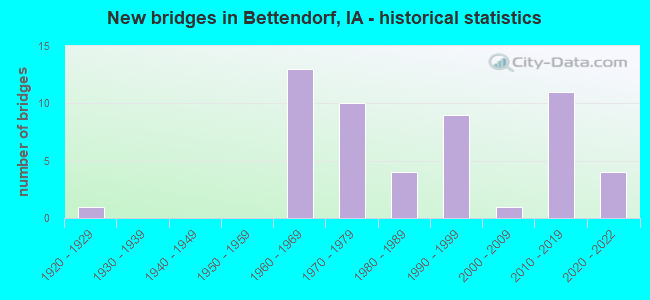
- New bridges - historical statistics
- 11920-1929
- 131960-1969
- 101970-1979
- 41980-1989
- 91990-1999
- 12000-2009
- 112010-2019
- 42020-2022
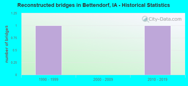
- Reconstructed bridges - Historical Statistics
- 11990-1999
- 02000-2009
- 12010-2019
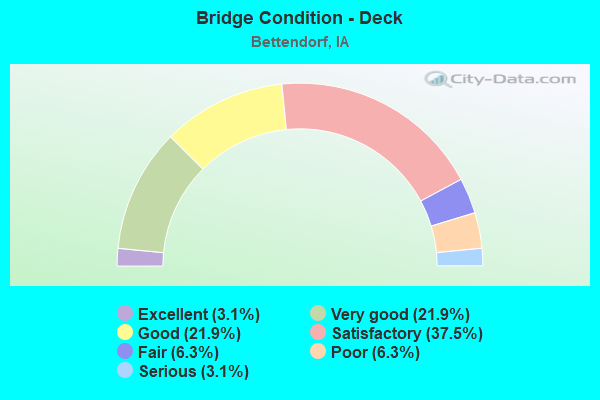
- Bridge Condition - Deck
- 3.1%Excellent
- 21.9%Very good
- 21.9%Good
- 37.5%Satisfactory
- 6.3%Fair
- 6.3%Poor
- 3.1%Serious
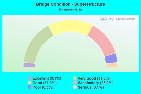
- Bridge Condition - Superstructure
- 3.1%Excellent
- 31.3%Very good
- 31.3%Good
- 25.0%Satisfactory
- 6.3%Poor
- 3.1%Serious
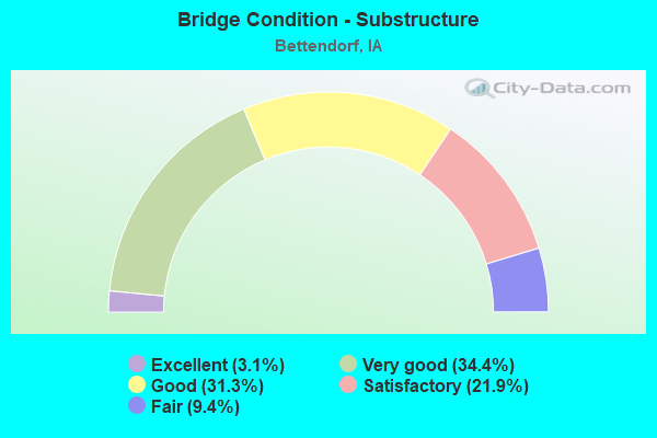
- Bridge Condition - Substructure
- 3.1%Excellent
- 34.4%Very good
- 31.3%Good
- 21.9%Satisfactory
- 9.4%Fair
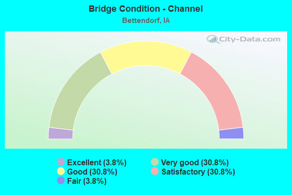
- Bridge Condition - Channel
- 3.8%Excellent
- 30.8%Very good
- 30.8%Good
- 30.8%Satisfactory
- 3.8%Fair
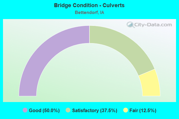
- Bridge Condition - Culverts
- 50.0%Good
- 37.5%Satisfactory
- 12.5%Fair
Find on map >> Show street view
Structure Number: 4735, Location: At jct. US 6 (Lat: 41.554628, Lng: -90.521817), Route carried "under" structure: US 6, Year Built: 1971, Structure Length: 0. m, Average Daily Traffic: 2,750 (year 2020), Truck Traffic: 2%, Features Intersected: US 6 (SPRUCE HILLS), Facility Carried by Structure: I 74 WB
Minimum Vertical Clearance: 30+ m (98+ ft), Kilometerpoint: 4.239, Lanes on structure: 2, Lanes under structure: 5, Material/Design: Prestressed concrete, Design/Construction: Stringer/Multi-beam, Length of Maximum Span: 22.3m (73.2ft)
Find on map >> Show street view
Structure Number: 4736, Location: 2.6 MI. E OF JCT. I-80 (Lat: 41.555233, Lng: -90.522144), Route carried "under" structure: US 6, Year Built: 1971, Structure Length: 0. m, Average Daily Traffic: 2,750 (year 2020), Truck Traffic: 2%, Features Intersected: US 6 (SPRUCE HILLS), Facility Carried by Structure: I 74 EB
Minimum Vertical Clearance: 30+ m (98+ ft), Kilometerpoint: 4.262, Lanes on structure: 3, Lanes under structure: 5, Material/Design: Prestressed concrete, Design/Construction: Stringer/Multi-beam, Length of Maximum Span: 22.3m (73.2ft)
Find on map >> Show street view
Structure Number: 4762, Location: 3.6 MI. E OF JCT. I-74 (Lat: 41.597036, Lng: -90.459269), Route carried "under" structure: City street , Year Built: 1963, Structure Length: 0. m, Average Daily Traffic: 2,500 (year 2018), Features Intersected: MIDDLE RD, Facility Carried by Structure: I 80 EB
Minimum Vertical Clearance: 30+ m (98+ ft), Kilometerpoint: 9.498, Lanes on structure: 2, Lanes under structure: 2, Material/Design: Prestressed concrete, Design/Construction: Stringer/Multi-beam, Length of Maximum Span: 14.6m (47.9ft)
Find on map >> Show street view
Structure Number: 4763, Location: 3.6 MI. E OF JCT I-74 (Lat: 41.597275, Lng: -90.458747), Route carried "under" structure: City street , Year Built: 1963, Structure Length: 0. m, Average Daily Traffic: 2,500 (year 2018), Features Intersected: MIDDLE RD, Facility Carried by Structure: I 80 WB
Minimum Vertical Clearance: 30+ m (98+ ft), Kilometerpoint: 9.526, Lanes on structure: 3, Lanes under structure: 2, Material/Design: Prestressed concrete, Design/Construction: Stringer/Multi-beam, Length of Maximum Span: 14.6m (47.9ft)
Find on map >> Show street view
Structure Number: 4767, Location: 3.5 mi. W of Jct. US 67 (Lat: 41.597450, Lng: -90.430892), Route carried "under" structure: County highway , Year Built: 1963, Structure Length: 0. m, Average Daily Traffic: 475 (year 2018), Truck Traffic: 17%, Features Intersected: CO RD (Z-30), Facility Carried by Structure: EB I-80
Minimum Vertical Clearance: 30+ m (98+ ft), Kilometerpoint: 3.389, Lanes on structure: 2, Lanes under structure: 2, Material/Design: Prestressed concrete, Design/Construction: Stringer/Multi-beam, Length of Maximum Span: 17.1m (56.1ft)
Find on map >> Show street view
Structure Number: 4768, Location: 3.5 MI. W OF JCT. US 67 (Lat: 41.597683, Lng: -90.430331), Route carried "under" structure: County highway , Year Built: 1963, Structure Length: 0. m, Average Daily Traffic: 475 (year 2018), Truck Traffic: 17%, Features Intersected: CO RD (Z-30), Facility Carried by Structure: WB I-80
Minimum Vertical Clearance: 30+ m (98+ ft), Kilometerpoint: 3.415, Lanes on structure: 2, Lanes under structure: 2, Material/Design: Prestressed concrete, Design/Construction: Stringer/Multi-beam, Length of Maximum Span: 17.1m (56.1ft)
Find on map >> Show street view
Structure Number: 604071, Location: 4.3 MI. S OF JCT. I-80 (Lat: 41.522336, Lng: -90.512061), Route carried "under" structure: US 67, Year Built: 2019, Structure Length: 0. m, Average Daily Traffic: 4,850 (year 2020), Truck Traffic: 6%, Features Intersected: US 67, RR, CITY STREETS, Facility Carried by Structure: I 74 & US 6 WB
Minimum Vertical Clearance: 30+ m (98+ ft), Kilometerpoint: 7.115, Lanes on structure: 3, Lanes under structure: 14, Material/Design: Steel continuous, Design/Construction: Stringer/Multi-beam, Length of Maximum Span: 52.6m (172.6ft)
Find on map >> Show street view
Structure Number: 605981, Location: 4.3 MI. S. OF JCT. I-80 (Lat: 41.523567, Lng: -90.512178), Route carried "under" structure: City street , Year Built: 2020, Structure Length: 0. m, Average Daily Traffic: 1,093 (year 1975), Features Intersected: DME RR & GILBERT ST, Facility Carried by Structure: I 74 WB RAMP
Minimum Vertical Clearance: 30+ m (98+ ft), Kilometerpoint: 0.319, Lanes on structure: 2, Lanes under structure: 2, Material/Design: Steel continuous, Design/Construction: Stringer/Multi-beam, Length of Maximum Span: 41.6m (136.5ft)
Find on map >> Show street view
Structure Number: 700035, Location: 4.3 MI. S OF JCT. I-80 (Lat: 41.528156, Lng: -90.513417), Route carried "under" structure: City street , Year Built: 2019, Structure Length: 0. m, Average Daily Traffic: 1,960 (year 2018), Features Intersected: MISSISSIPPI BLVD, Facility Carried by Structure: US67 TO I74 RAMP
Minimum Vertical Clearance: 30+ m (98+ ft), Kilometerpoint: 1.205, Lanes on structure: 2, Lanes under structure: 2, Material/Design: Steel, Design/Construction: Stringer/Multi-beam, Length of Maximum Span: 42.0m (137.8ft)
Find on map >> Show street view
Structure Number: 70004, Location: EB. I-74 RAMP A TO US 6 7 (Lat: 41.528447, Lng: -90.514517), Route carried "under" structure: City street , Year Built: 2019, Structure Length: 0. m, Average Daily Traffic: 1,960 (year 2018), Features Intersected: MISSISSIPPI BLVD, Facility Carried by Structure: I 74 EB OFF RAMP
Minimum Vertical Clearance: 30+ m (98+ ft), Kilometerpoint: 1.123, Lanes on structure: 2, Lanes under structure: 2, Material/Design: Steel continuous, Design/Construction: Stringer/Multi-beam, Length of Maximum Span: 41.1m (134.8ft)