Bridge Statistics for Binghamton, New York (NY)
Condition, Traffic, Stress, Structural Evaluation, Project Costs
- National Bridge Inventory (NBI) Statistics
- 107Number of bridges
- 1,627ft / 496mTotal length
- $323,937,000Total costs
- 980,829Total average daily traffic
- 69,340Total average daily truck traffic
- National Bridge Inventory (NBI) Registered Bridges for Binghamton
- No street view available for this location
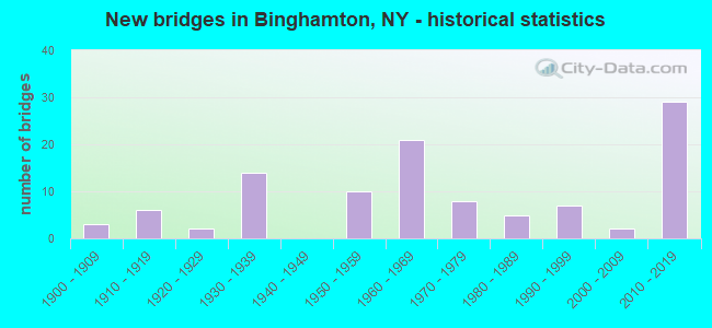
- New bridges - historical statistics
- 31900-1909
- 61910-1919
- 21920-1929
- 141930-1939
- 101950-1959
- 211960-1969
- 81970-1979
- 51980-1989
- 71990-1999
- 22000-2009
- 292010-2019
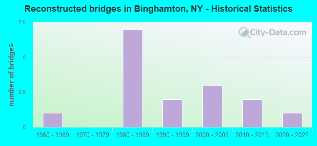
- Reconstructed bridges - Historical Statistics
- 11960-1969
- 01970-1979
- 71980-1989
- 21990-1999
- 32000-2009
- 22010-2019
- 12020-2022
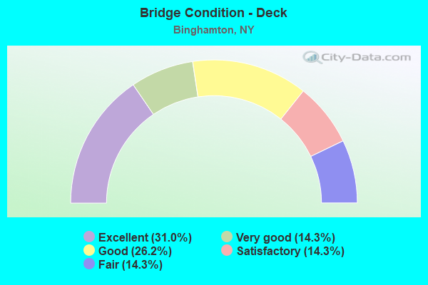
- Bridge Condition - Deck
- 31.0%Excellent
- 14.3%Very good
- 26.2%Good
- 14.3%Satisfactory
- 14.3%Fair
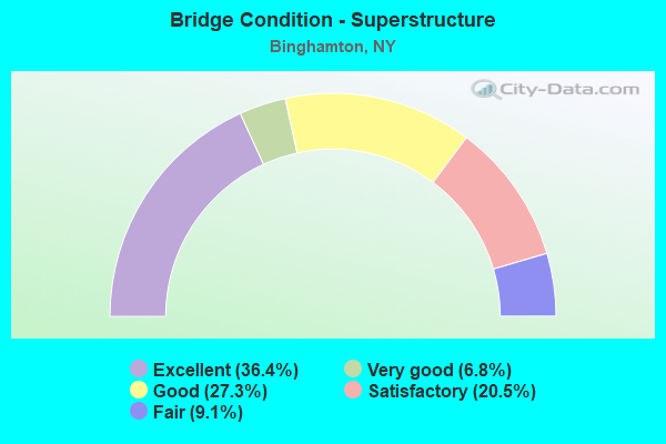
- Bridge Condition - Superstructure
- 36.4%Excellent
- 6.8%Very good
- 27.3%Good
- 20.5%Satisfactory
- 9.1%Fair
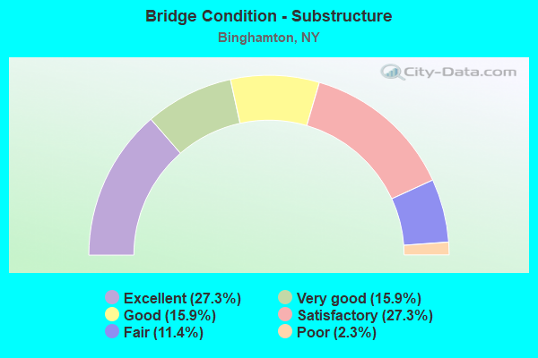
- Bridge Condition - Substructure
- 27.3%Excellent
- 15.9%Very good
- 15.9%Good
- 27.3%Satisfactory
- 11.4%Fair
- 2.3%Poor
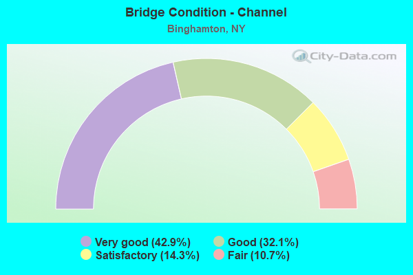
- Bridge Condition - Channel
- 42.9%Very good
- 32.1%Good
- 14.3%Satisfactory
- 10.7%Fair
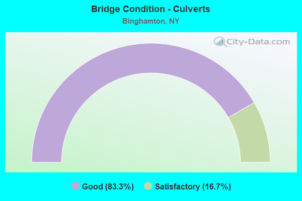
- Bridge Condition - Culverts
- 83.3%Good
- 16.7%Satisfactory
Find on map >> Show street view
Structure Number: 100362, Location: JCT SH 7 & SUSQUEHANNA RV (Lat: 42.101000, Lng: -75.896808), Route carried "on" structure: State highway 7, Year Built: 1963, Year Reconstructed: 2007, Status: Open, Structure Length: 13.11m (43.01ft), Average Daily Traffic: 10,342 (year 2017), Truck Traffic: 4%, Average Future Daily Traffic: 12,563 (year 2040), Design Load: HS 20, Features Intersected: SUSQUEHANNA RIVER
Minimum Vertical Clearance: 30+ m (98+ ft), Kilometerpoint: 17.651, Lanes on structure: 3, Base Highway Network: Yes, Owner: State Highway Agency, Approaching Roadway Width: 14.3m (46.9ft), Skew: 1 degrees, Material/Design: Steel, Design/Construction: Stringer/Multi-beam, Number Of Spans In Main Unit: 3, Length of Maximum Span: 50.9m (167.0ft), Curb or Sidewalk Widths: Left: 1.6m (5.2ft), Right: 1.6m (5.2ft), Curb-To-Curb Width: 14.4m (47.2ft), Out-to-Out Width: 18.5m (60.7ft)
Condition: Deck: Good, Superstructure: Satisfactory, Substructure: Good, Channel: Very good, Operating Rating: 59.9 metric tons, Method Used To Determine Operating Rating: Load Factor (LF), Inventory Rating: 35.4 metric tons, Method Used To Determine Inventory Rating: Load Factor (LF), Structural Evaluation: Equal to present minimum criteria, Deck Geometry: Somewhat better than minimum adequacy, Waterway Adequacy: Equal to present minimum criteria, Approach Roadway Alignment: Equal to present desirable criteria, Length Of Structure Improvement: 13.10m (42.98ft), Designated Inspection Frequency: Every 24 months, Underwater Inspection Frequency: Every 60 months, Inspection Date: September 2020, Underwater Inspection Date: August 2018, Bridge Improvement Cost: $5,254,000, Roadway Improvement Cost: $3,077,000, Total Project Cost: $8,331,000 ( Estimate for 2021), Deck Structure Type: Concrete Cast-file-Place, Wearing Surface/Protective System: Wearing Surface: Monolithic Concrete, Deck Protection: Epoxy Coated Reinforcing
Find on map >> Show street view
Structure Number: 100367, Location: 0.3 MI S JCT RTS 363 + 7 (Lat: 42.107964, Lng: -75.898833), Route carried "on" structure: State highway 363, Year Built: 1965, Status: Open, Structure Length: 1.37m (4.49ft), Average Daily Traffic: 14,302 (year 2014), Truck Traffic: 5%, Average Future Daily Traffic: 16,573 (year 2040), Design Load: HS 20+Mod, Features Intersected: ROUTE 7 RAMP
Minimum Vertical Clearance: 30+ m (98+ ft), Kilometerpoint: 2.027, Lanes on structure: 4, Lanes under structure: 1, Base Highway Network: Yes, Owner: State Highway Agency, Approaching Roadway Width: 17.1m (56.1ft), Skew: 24 degrees, Material/Design: Steel, Design/Construction: Stringer/Multi-beam, Number Of Spans In Main Unit: 1, Length of Maximum Span: 13.4m (44.0ft), Curb-To-Curb Width: 17.6m (57.7ft), Out-to-Out Width: 19.1m (62.7ft)
Condition: Deck: Fair, Superstructure: Satisfactory, Substructure: Fair, Operating Rating: 86.2 metric tons, Method Used To Determine Operating Rating: Load Factor (LF), Inventory Rating: 51.7 metric tons, Method Used To Determine Inventory Rating: Load Factor (LF), Structural Evaluation: Somewhat better than minimum adequacy, Deck Geometry: Meets minimum limits, Underclear: High priority of corrective action, Approach Roadway Alignment: Equal to present desirable criteria, Length Of Structure Improvement: 1.40m (4.59ft), Designated Inspection Frequency: Every 24 months, Inspection Date: May 2021, Bridge Improvement Cost: $1,693,000, Roadway Improvement Cost: $991,000, Total Project Cost: $2,684,000 ( Estimate for 2021), Deck Structure Type: Concrete Cast-file-Place, Wearing Surface/Protective System: Wearing Surface: Integral Concrete
Find on map >> Show street view
Structure Number: 1003681, Location: 0.3 MI N JCT RTS 7 & I-81 (Lat: 42.118997, Lng: -75.895242), Route carried "on" structure: State highway 7, Year Built: 1994, Status: Open, Structure Length: 3.02m (9.91ft), Average Daily Traffic: 8,420 (year 2015), Truck Traffic: 6%, Average Future Daily Traffic: 9,756 (year 2040), Design Load: HS 25 or greater, Features Intersected: BEVIER STREET
Minimum Vertical Clearance: 30+ m (98+ ft), Kilometerpoint: 19.710, Lanes on structure: 2, Lanes under structure: 3, Base Highway Network: Yes, Owner: State Highway Agency, Approaching Roadway Width: 12.2m (40.0ft), Skew: 2 degrees, Material/Design: Prestressed concrete, Design/Construction: Box Beam or Girders - Multiple, Number Of Spans In Main Unit: 1, Length of Maximum Span: 28.6m (93.8ft), Curb-To-Curb Width: 12.3m (40.4ft), Out-to-Out Width: 13.3m (43.6ft)
Condition: Deck: Fair, Superstructure: Satisfactory, Substructure: Satisfactory, Operating Rating: 80.7 metric tons, Method Used To Determine Operating Rating: Load Factor (LF), Inventory Rating: 43.5 metric tons, Method Used To Determine Inventory Rating: Load Factor (LF), Structural Evaluation: Equal to present minimum criteria, Deck Geometry: Better than present minimum criteria, Underclear: Somewhat better than minimum adequacy, Approach Roadway Alignment: Equal to present desirable criteria, Length Of Structure Improvement: 3.01m (9.88ft), Designated Inspection Frequency: Every 24 months, Inspection Date: June 2020, Bridge Improvement Cost: $1,283,000, Roadway Improvement Cost: $751,000, Total Project Cost: $2,035,000 ( Estimate for 2021), Wearing Surface/Protective System: Wearing Surface: Monolithic Concrete
Find on map >> Show street view
Structure Number: 1003682, Location: 0.3 MI N JCT RTS 7 & I-81 (Lat: 42.119003, Lng: -75.895064), Route carried "on" structure: State highway 7, Year Built: 1994, Status: Open, Structure Length: 3.02m (9.91ft), Average Daily Traffic: 8,420 (year 2015), Truck Traffic: 6%, Average Future Daily Traffic: 9,756 (year 2040), Design Load: HS 25 or greater, Features Intersected: BEVIER STREET
Minimum Vertical Clearance: 30+ m (98+ ft), Kilometerpoint: 19.710, Lanes on structure: 2, Lanes under structure: 3, Base Highway Network: Yes, Owner: State Highway Agency, Approaching Roadway Width: 12.2m (40.0ft), Skew: 2 degrees, Material/Design: Prestressed concrete, Design/Construction: Box Beam or Girders - Multiple, Number Of Spans In Main Unit: 1, Length of Maximum Span: 28.6m (93.8ft), Curb-To-Curb Width: 12.3m (40.4ft), Out-to-Out Width: 13.3m (43.6ft)
Condition: Deck: Fair, Superstructure: Good, Substructure: Good, Operating Rating: 99.8 metric tons, Method Used To Determine Operating Rating: Load Factor (LF), Inventory Rating: 49.0 metric tons, Method Used To Determine Inventory Rating: Load Factor (LF), Structural Evaluation: Better than present minimum criteria, Deck Geometry: Better than present minimum criteria, Underclear: Somewhat better than minimum adequacy, Approach Roadway Alignment: Equal to present desirable criteria, Length Of Structure Improvement: 3.01m (9.88ft), Designated Inspection Frequency: Every 24 months, Inspection Date: June 2020, Bridge Improvement Cost: $1,301,000, Roadway Improvement Cost: $762,000, Total Project Cost: $2,062,000 ( Estimate for 2021), Wearing Surface/Protective System: Wearing Surface: Monolithic Concrete
Find on map >> Show street view
Structure Number: 1008169, Location: JCT RTS 363 + 11 (Lat: 42.101764, Lng: -75.899956), Route carried "on" structure: State highway 363, Year Built: 1965, Year Reconstructed: 2001, Status: Open, Structure Length: 47.15m (154.69ft), Average Daily Traffic: 16,085 (year 2020), Truck Traffic: 5%, Average Future Daily Traffic: 18,639 (year 2040), Design Load: HS 20+Mod, Features Intersected: ELDREDGE STREET, PINE ST
Minimum Vertical Clearance: 30+ m (98+ ft), Kilometerpoint: 1.303, Lanes on structure: 4, Lanes under structure: 11, Base Highway Network: Yes, Owner: State Highway Agency, Approaching Roadway Width: 17.1m (56.1ft), Skew: 22 degrees, Material/Design: Steel, Design/Construction: Stringer/Multi-beam, Number Of Spans In Main Unit: 17, Length of Maximum Span: 35.0m (114.8ft), Curb-To-Curb Width: 17.1m (56.1ft), Out-to-Out Width: 18.6m (61.0ft)
Condition: Deck: Satisfactory, Superstructure: Good, Substructure: Satisfactory, Operating Rating: 69.9 metric tons, Method Used To Determine Operating Rating: Load Factor (LF), Inventory Rating: 41.7 metric tons, Method Used To Determine Inventory Rating: Load Factor (LF), Structural Evaluation: Equal to present minimum criteria, Deck Geometry: Meets minimum limits, Underclear: Meets minimum limits, Approach Roadway Alignment: Equal to present desirable criteria, Length Of Structure Improvement: 47.15m (154.69ft), Designated Inspection Frequency: Every 24 months, Inspection Date: December 2020, Bridge Improvement Cost: $17,727,000, Roadway Improvement Cost: $10,381,000, Total Project Cost: $28,108,000 ( Estimate for 2021), Deck Structure Type: Concrete Cast-file-Place, Wearing Surface/Protective System: Wearing Surface: Monolithic Concrete
Find on map >> Show street view
Structure Number: 101301, Location: 0.4 MI SW JCT RTS 434+363 (Lat: 42.089781, Lng: -75.916256), Route carried "on" structure: City street , Year Built: 1954, Year Reconstructed: 1986, Status: Open, Structure Length: 5.21m (17.09ft), Average Daily Traffic: 3,712 (year 2020), Truck Traffic: 4%, Average Future Daily Traffic: 4,509 (year 2040), Design Load: HS 20, Features Intersected: 434 434 91012018 EB, Ped, Facility Carried by Structure: PENNSYLVANIA AVE
Minimum Vertical Clearance: 30+ m (98+ ft), Kilometerpoint: 1.931, Lanes on structure: 2, Lanes under structure: 6, Owner: State Highway Agency, Approaching Roadway Width: 9.1m (29.9ft), Skew: 2 degrees, Material/Design: Steel, Design/Construction: Stringer/Multi-beam, Number Of Spans In Main Unit: 3, Length of Maximum Span: 29.2m (95.8ft), Curb or Sidewalk Widths: Left: 0.0m, Right: 2.8m (9.2ft), Curb-To-Curb Width: 9.1m (29.9ft), Out-to-Out Width: 13.6m (44.6ft)
Condition: Deck: Very good, Superstructure: Very good, Substructure: Very good, Operating Rating: 85.3 metric tons, Method Used To Determine Operating Rating: Load Factor (LF), Inventory Rating: 50.8 metric tons, Method Used To Determine Inventory Rating: Load Factor (LF), Structural Evaluation: Equal to present desirable criteria, Deck Geometry: Meets minimum limits, Underclear: High priority of corrective action, Approach Roadway Alignment: Equal to present desirable criteria, Length Of Structure Improvement: 5.21m (17.09ft), Designated Inspection Frequency: Every 24 months, Inspection Date: October 2021, Bridge Improvement Cost: $1,677,000, Roadway Improvement Cost: $982,000, Total Project Cost: $2,659,000 ( Estimate for 2021), Deck Structure Type: Concrete Cast-file-Place, Wearing Surface/Protective System: Wearing Surface: Epoxy Overlay, Deck Protection: Epoxy Coated Reinforcing
Find on map >> Show street view
Structure Number: 1013022, Location: JCT RTE 434 & SUSQUEHANNA (Lat: 42.092644, Lng: -75.911250), Route carried "on" structure: State highway 434, Year Built: 1956, Year Reconstructed: 1993, Status: Open, Structure Length: 19.75m (64.80ft), Average Daily Traffic: 9,929 (year 2018), Truck Traffic: 4%, Average Future Daily Traffic: 11,505 (year 2040), Design Load: HS 20, Features Intersected: RTE 363, SUSQUEHANNA RIV
Minimum Vertical Clearance: 30+ m (98+ ft), Kilometerpoint: 17.458, Lanes on structure: 3, Lanes under structure: 7, Base Highway Network: Yes, Owner: State Highway Agency, Approaching Roadway Width: 11.6m (38.1ft), Material/Design: Steel continuous, Design/Construction: Girder and Floorbeam System, Number Of Spans In Main Unit: 3, Number Of Approach Spans: 2, Length of Maximum Span: 62.1m (203.7ft), Curb or Sidewalk Widths: Left: 0.0m, Right: 1.5m (4.9ft), Curb-To-Curb Width: 11.4m (37.4ft), Out-to-Out Width: 13.7m (44.9ft)
Condition: Deck: Satisfactory, Superstructure: Good, Substructure: Satisfactory, Channel: Satisfactory, Operating Rating: 44.5 metric tons, Method Used To Determine Operating Rating: Load Factor (LF), Inventory Rating: 26.3 metric tons, Method Used To Determine Inventory Rating: Load Factor (LF), Structural Evaluation: Equal to present minimum criteria, Deck Geometry: High priority of replacement, Underclear: High priority of corrective action, Waterway Adequacy: Equal to present minimum criteria, Approach Roadway Alignment: Equal to present desirable criteria, Length Of Structure Improvement: 19.75m (64.80ft), Designated Inspection Frequency: Every 24 months, Critical Feature Inspection Frequency: Every 24 months, Underwater Inspection Frequency: Every 60 months, Inspection Date: October 2021, Critical Feature Inspection Date: October 2021, Underwater Inspection Date: August 2018, Bridge Improvement Cost: $6,053,000, Roadway Improvement Cost: $3,544,000, Total Project Cost: $9,597,000 ( Estimate for 2021), Deck Structure Type: Concrete Cast-file-Place, Wearing Surface/Protective System: Wearing Surface: Integral Concrete, Deck Protection: Epoxy Coated Reinforcing
Find on map >> Show street view
Structure Number: 1013039, Location: 0.2 MI E JCT RTS 363+434 (Lat: 42.094697, Lng: -75.908331), Route carried "on" structure: State highway 363, Year Built: 1963, Year Reconstructed: 1993, Status: Open, Structure Length: 3.84m (12.60ft), Average Daily Traffic: 16,085 (year 2020), Truck Traffic: 2%, Average Future Daily Traffic: 18,639 (year 2040), Design Load: HS 20, Features Intersected: EXCHANGE STREET
Minimum Vertical Clearance: 30+ m (98+ ft), Kilometerpoint: 0.129, Lanes on structure: 4, Lanes under structure: 3, Base Highway Network: Yes, Owner: State Highway Agency, Approaching Roadway Width: 17.1m (56.1ft), Skew: 20 degrees, Material/Design: Steel, Design/Construction: Stringer/Multi-beam, Number Of Spans In Main Unit: 3, Length of Maximum Span: 16.1m (52.8ft), Curb-To-Curb Width: 17.1m (56.1ft), Out-to-Out Width: 18.7m (61.4ft)
Condition: Deck: Good, Superstructure: Satisfactory, Substructure: Fair, Operating Rating: 54.1 metric tons, Method Used To Determine Operating Rating: Load and Resistance Factor Rating (LRFR) rating reported by rating factor(RF) method using HL-93 loadings, Inventory Rating: 41.8 metric tons, Method Used To Determine Inventory Rating: Load and Resistance Factor Rating (LRFR) rating reported by rating factor(RF) method using HL-93 loadings, Structural Evaluation: Somewhat better than minimum adequacy, Deck Geometry: High priority of corrective action, Underclear: High priority of corrective action, Approach Roadway Alignment: Equal to present desirable criteria, Length Of Structure Improvement: 3.84m (12.60ft), Designated Inspection Frequency: Every 24 months, Inspection Date: August 2021, Bridge Improvement Cost: $1,664,000, Roadway Improvement Cost: $975,000, Total Project Cost: $2,639,000 ( Estimate for 2021), Deck Structure Type: Concrete Cast-file-Place, Wearing Surface/Protective System: Wearing Surface: Integral Concrete, Deck Protection: Epoxy Coated Reinforcing
Find on map >> Show street view
Structure Number: 101304, Location: .4 MI E JCT SH 363 & SH 4 (Lat: 42.095472, Lng: -75.904806), Route carried "on" structure: State highway 363, Year Built: 1965, Status: Open, Structure Length: 4.88m (16.01ft), Average Daily Traffic: 16,085 (year 2020), Truck Traffic: 2%, Average Future Daily Traffic: 18,639 (year 2040), Design Load: HS 20, Features Intersected: RTE 363
Minimum Vertical Clearance: 30+ m (98+ ft), Kilometerpoint: 0.434, Lanes on structure: 2, Lanes under structure: 3, Base Highway Network: Yes, Owner: State Highway Agency, Approaching Roadway Width: 9.4m (30.8ft), Skew: 6 degrees, Material/Design: Steel, Design/Construction: Stringer/Multi-beam, Number Of Spans In Main Unit: 1, Length of Maximum Span: 44.1m (144.7ft), Curb-To-Curb Width: 9.1m (29.9ft), Out-to-Out Width: 10.0m (32.8ft)
Condition: Deck: Fair, Superstructure: Fair, Substructure: Satisfactory, Inventory Rating: 63.5 metric tons, Method Used To Determine Inventory Rating: Load Factor (LF), Structural Evaluation: Somewhat better than minimum adequacy, Deck Geometry: High priority of replacement, Underclear: High priority of corrective action, Approach Roadway Alignment: Equal to present desirable criteria, Length Of Structure Improvement: 4.87m (15.98ft), Designated Inspection Frequency: Every 24 months, Inspection Date: July 2020, Bridge Improvement Cost: $2,391,000, Roadway Improvement Cost: $1,400,000, Total Project Cost: $3,791,000 ( Estimate for 2021), Deck Structure Type: Concrete Cast-file-Place, Wearing Surface/Protective System: Wearing Surface: Monolithic Concrete
Find on map >> Show street view
Structure Number: 1013059, Location: 0.3 MI S JCT RTS 363 + 7 (Lat: 42.106900, Lng: -75.899278), Route carried "on" structure: State highway 363, Year Built: 1963, Year Reconstructed: 1993, Status: Open, Structure Length: 3.87m (12.70ft), Average Daily Traffic: 14,302 (year 2014), Truck Traffic: 5%, Average Future Daily Traffic: 16,573 (year 2040), Design Load: HS 20, Features Intersected: ROBINSON STREET
Minimum Vertical Clearance: 30+ m (98+ ft), Kilometerpoint: 1.883, Lanes on structure: 4, Lanes under structure: 3, Base Highway Network: Yes, Owner: State Highway Agency, Approaching Roadway Width: 17.1m (56.1ft), Skew: 21 degrees, Material/Design: Steel, Design/Construction: Stringer/Multi-beam, Number Of Spans In Main Unit: 3, Length of Maximum Span: 17.3m (56.8ft), Curb-To-Curb Width: 17.1m (56.1ft), Out-to-Out Width: 18.7m (61.4ft)
Condition: Deck: Satisfactory, Superstructure: Satisfactory, Substructure: Satisfactory, Operating Rating: 47.3 metric tons, Method Used To Determine Operating Rating: Load and Resistance Factor Rating (LRFR) rating reported by rating factor(RF) method using HL-93 loadings, Inventory Rating: 36.6 metric tons, Method Used To Determine Inventory Rating: Load and Resistance Factor Rating (LRFR) rating reported by rating factor(RF) method using HL-93 loadings, Structural Evaluation: Equal to present minimum criteria, Deck Geometry: High priority of corrective action, Underclear: Somewhat better than minimum adequacy, Approach Roadway Alignment: Equal to present desirable criteria, Length Of Structure Improvement: 3.87m (12.70ft), Designated Inspection Frequency: Every 24 months, Inspection Date: June 2021, Bridge Improvement Cost: $1,688,000, Roadway Improvement Cost: $989,000, Total Project Cost: $2,677,000 ( Estimate for 2021), Deck Structure Type: Concrete Cast-file-Place, Wearing Surface/Protective System: Wearing Surface: Integral Concrete, Deck Protection: Epoxy Coated Reinforcing
Find on map >> Show street view
Structure Number: 101306, Location: .3 mi E Jct Rt 7 (Lat: 42.114950, Lng: -75.902469), Route carried "on" structure: Interstate 81, Year Built: 2014, Status: Open, Structure Length: 1.89m (6.20ft), Average Daily Traffic: 47,369 (year 2020), Truck Traffic: 21%, Average Future Daily Traffic: 62,309 (year 2040), Design Load: HS 25 or greater, Features Intersected: Chenango St
Minimum Vertical Clearance: 32.69m (107.25ft), Kilometerpoint: 20.611, Lanes on structure: 11, Lanes under structure: 2, Base Highway Network: Yes, Owner: State Highway Agency, Approaching Roadway Width: 55.7m (182.7ft), Skew: 20 degrees, Material/Design: Concrete, Design/Construction: Frame, Number Of Spans In Main Unit: 1, Length of Maximum Span: 18.3m (60.0ft), Curb-To-Curb Width: 55.7m (182.7ft), Out-to-Out Width: 62.9m (206.4ft)
Condition: Superstructure: Fair, Substructure: Good, Operating Rating: 85.6 metric tons, Method Used To Determine Operating Rating: Field evaluation and documented engineering judgment, Inventory Rating: 40.8 metric tons, Method Used To Determine Inventory Rating: Field evaluation and documented engineering judgment, Structural Evaluation: Somewhat better than minimum adequacy, Deck Geometry: Superior to present desirable criteria, Underclear: Meets minimum limits, Approach Roadway Alignment: Equal to present desirable criteria, Length Of Structure Improvement: 1.88m (6.17ft), Designated Inspection Frequency: Every 24 months, Inspection Date: April 2021, Bridge Improvement Cost: $2,961,000, Roadway Improvement Cost: $1,734,000, Total Project Cost: $4,695,000 ( Estimate for 2021)
Find on map >> Show street view
Structure Number: 101308, Location: 0.4 MI E EXIT 3 RTE I-81 (Lat: 42.114403, Lng: -75.881933), Route carried "on" structure: City street , Year Built: 1965, Year Reconstructed: 1992, Status: Open, Structure Length: 4.11m (13.48ft), Average Daily Traffic: 1,272 (year 2020), Truck Traffic: 2%, Average Future Daily Traffic: 1,573 (year 2040), Design Load: HS 20, Features Intersected: 81I 81I91012013, RTE I81, Facility Carried by Structure: BIGELOW STREET
Minimum Vertical Clearance: 30+ m (98+ ft), Kilometerpoint: 1.094, Lanes on structure: 2, Lanes under structure: 6, Owner: State Highway Agency, Approaching Roadway Width: 9.1m (29.9ft), Skew: 3 degrees, Material/Design: Steel, Design/Construction: Stringer/Multi-beam, Number Of Spans In Main Unit: 2, Length of Maximum Span: 19.5m (64.0ft), Curb or Sidewalk Widths: Left: 1.5m (4.9ft), Right: 1.5m (4.9ft), Curb-To-Curb Width: 9.1m (29.9ft), Out-to-Out Width: 12.8m (42.0ft)
Condition: Deck: Good, Superstructure: Good, Substructure: Poor, Operating Rating: 63.5 metric tons, Method Used To Determine Operating Rating: Load Factor (LF), Inventory Rating: 38.1 metric tons, Method Used To Determine Inventory Rating: Load Factor (LF), Structural Evaluation: Meets minimum limits, Deck Geometry: Somewhat better than minimum adequacy, Underclear: High priority of corrective action, Approach Roadway Alignment: Equal to present desirable criteria, Length Of Structure Improvement: 4.11m (13.48ft), Designated Inspection Frequency: Every 24 months, Inspection Date: November 2020, Bridge Improvement Cost: $2,147,000, Roadway Improvement Cost: $1,257,000, Total Project Cost: $3,404,000 ( Estimate for 2021), Deck Structure Type: Concrete Cast-file-Place, Wearing Surface/Protective System: Wearing Surface: Integral Concrete, Deck Protection: Epoxy Coated Reinforcing
Find on map >> Show street view
Structure Number: 101309, Location: .6 MI E EXIT 3 OF I81 (Lat: 42.112953, Lng: -75.877047), Route carried "on" structure: City street , Year Built: 1965, Year Reconstructed: 1992, Status: Open, Structure Length: 3.78m (12.40ft), Average Daily Traffic: 550 (year 2020), Truck Traffic: 3%, Average Future Daily Traffic: 680 (year 2040), Design Load: HS 20, Features Intersected: 81I 81I91012010, RTE I81, Facility Carried by Structure: FAIRVIEW AVENUE
Minimum Vertical Clearance: 30+ m (98+ ft), Kilometerpoint: 0.949, Lanes on structure: 2, Lanes under structure: 6, Owner: State Highway Agency, Approaching Roadway Width: 9.1m (29.9ft), Skew: 2 degrees, Material/Design: Steel, Design/Construction: Stringer/Multi-beam, Number Of Spans In Main Unit: 2, Length of Maximum Span: 17.9m (58.7ft), Curb or Sidewalk Widths: Left: 1.5m (4.9ft), Right: 1.5m (4.9ft), Curb-To-Curb Width: 9.1m (29.9ft), Out-to-Out Width: 12.8m (42.0ft)
Condition: Deck: Good, Superstructure: Good, Substructure: Fair, Operating Rating: 88.0 metric tons, Method Used To Determine Operating Rating: Load Factor (LF), Inventory Rating: 52.6 metric tons, Method Used To Determine Inventory Rating: Load Factor (LF), Structural Evaluation: Somewhat better than minimum adequacy, Deck Geometry: Equal to present minimum criteria, Underclear: High priority of corrective action, Approach Roadway Alignment: Equal to present desirable criteria, Length Of Structure Improvement: 3.77m (12.37ft), Designated Inspection Frequency: Every 24 months, Inspection Date: November 2020, Bridge Improvement Cost: $1,827,000, Roadway Improvement Cost: $1,070,000, Total Project Cost: $2,898,000 ( Estimate for 2021), Deck Structure Type: Concrete Cast-file-Place, Wearing Surface/Protective System: Wearing Surface: Integral Concrete, Deck Protection: Epoxy Coated Reinforcing
Find on map >> Show street view
Structure Number: 10131, Location: 1.3 MI E EXIT 3 OF I81 (Lat: 42.109908, Lng: -75.865461), Route carried "on" structure: City street , Year Built: 1965, Year Reconstructed: 1992, Status: Open, Structure Length: 3.75m (12.30ft), Average Daily Traffic: 58 (year 2018), Truck Traffic: 7%, Average Future Daily Traffic: 81 (year 2038), Design Load: HS 20, Features Intersected: 81I 81I91012004, RTE I81, Facility Carried by Structure: WINDY HILL ROAD
Minimum Vertical Clearance: 30+ m (98+ ft), Kilometerpoint: 0.129, Lanes on structure: 2, Lanes under structure: 6, Owner: State Highway Agency, Approaching Roadway Width: 7.9m (25.9ft), Skew: 1 degrees, Material/Design: Steel, Design/Construction: Stringer/Multi-beam, Number Of Spans In Main Unit: 2, Length of Maximum Span: 18.3m (60.0ft), Curb-To-Curb Width: 8.0m (26.2ft), Out-to-Out Width: 8.9m (29.2ft)
Condition: Deck: Good, Superstructure: Satisfactory, Substructure: Fair, Operating Rating: 94.3 metric tons, Method Used To Determine Operating Rating: Load Factor (LF), Inventory Rating: 56.2 metric tons, Method Used To Determine Inventory Rating: Load Factor (LF), Structural Evaluation: Somewhat better than minimum adequacy, Deck Geometry: Equal to present minimum criteria, Underclear: High priority of corrective action, Approach Roadway Alignment: Equal to present minimum criteria, Length Of Structure Improvement: 3.74m (12.27ft), Designated Inspection Frequency: Every 24 months, Inspection Date: November 2020, Bridge Improvement Cost: $1,325,000, Roadway Improvement Cost: $776,000, Total Project Cost: $2,101,000 ( Estimate for 2021), Deck Structure Type: Concrete Cast-file-Place, Wearing Surface/Protective System: Wearing Surface: Integral Concrete, Deck Protection: Epoxy Coated Reinforcing
Find on map >> Show street view
Structure Number: 1031181, Location: JCT I81 & CHENANGO RIVER (Lat: 42.115181, Lng: -75.908378), Route carried "on" structure: Interstate 81, Year Built: 2014, Status: Open, Structure Length: 30.72m (100.79ft), Average Daily Traffic: 34,547 (year 2008), Truck Traffic: 24%, Average Future Daily Traffic: 48,365 (year 2028), Design Load: HL 93, Features Intersected: 17 17 91072017, 17 17 91
Minimum Vertical Clearance: 5.18m (16.99ft), Kilometerpoint: 20.869, Lanes on structure: 2, Lanes under structure: 10, Base Highway Network: Yes, Owner: State Highway Agency, Approaching Roadway Width: 11.6m (38.1ft), Skew: 1 degrees, Material/Design: Steel continuous, Design/Construction: Stringer/Multi-beam, Number Of Spans In Main Unit: 6, Length of Maximum Span: 63.7m (209.0ft), Curb-To-Curb Width: 11.7m (38.4ft), Out-to-Out Width: 12.7m (41.7ft)
Condition: Deck: Excellent, Superstructure: Excellent, Substructure: Excellent, Channel: Very good, Operating Rating: 63.5 metric tons, Method Used To Determine Operating Rating: Load Factor (LF), Inventory Rating: 37.2 metric tons, Method Used To Determine Inventory Rating: Load Factor (LF), Structural Evaluation: Superior to present desirable criteria, Deck Geometry: Equal to present minimum criteria, Underclear: High priority of corrective action, Waterway Adequacy: Equal to present desirable criteria, Approach Roadway Alignment: Equal to present desirable criteria, Length Of Structure Improvement: 30.72m (100.79ft), Designated Inspection Frequency: Every 24 months, Inspection Date: August 2021, Bridge Improvement Cost: $8,435,000, Roadway Improvement Cost: $4,939,000, Total Project Cost: $13,374,000 ( Estimate for 2021), Deck Structure Type: Concrete Cast-file-Place, Wearing Surface/Protective System: Wearing Surface: Integral Concrete, Deck Protection: Other Coated Reinforcing
Find on map >> Show street view
Structure Number: 1031182, Location: JCT I81 & CHENANGO RIVER (Lat: 42.116272, Lng: -75.907922), Route carried "on" structure: Interstate 81, Year Built: 2014, Status: Open, Structure Length: 27.43m (89.99ft), Average Daily Traffic: 23,685 (year 2020), Truck Traffic: 21%, Average Future Daily Traffic: 31,154 (year 2040), Design Load: HL 93, Features Intersected: 17 17 9107 06D1, RTE 11,
Minimum Vertical Clearance: 5.38m (17.65ft), Kilometerpoint: 20.885, Lanes on structure: 3, Lanes under structure: 4, Base Highway Network: Yes, Owner: State Highway Agency, Approaching Roadway Width: 14.3m (46.9ft), Material/Design: Steel continuous, Design/Construction: Stringer/Multi-beam, Number Of Spans In Main Unit: 5, Length of Maximum Span: 63.7m (209.0ft), Curb-To-Curb Width: 14.3m (46.9ft), Out-to-Out Width: 15.2m (49.9ft)
Condition: Deck: Excellent, Superstructure: Excellent, Substructure: Excellent, Channel: Very good, Operating Rating: 62.6 metric tons, Method Used To Determine Operating Rating: Load Factor (LF), Inventory Rating: 37.2 metric tons, Method Used To Determine Inventory Rating: Load Factor (LF), Structural Evaluation: Superior to present desirable criteria, Deck Geometry: Meets minimum limits, Underclear: Meets minimum limits, Waterway Adequacy: Equal to present desirable criteria, Approach Roadway Alignment: Equal to present desirable criteria, Length Of Structure Improvement: 27.43m (89.99ft), Designated Inspection Frequency: Every 24 months, Inspection Date: August 2021, Bridge Improvement Cost: $9,102,000, Roadway Improvement Cost: $5,330,000, Total Project Cost: $14,432,000 ( Estimate for 2021), Deck Structure Type: Concrete Cast-file-Place, Wearing Surface/Protective System: Wearing Surface: Integral Concrete, Deck Protection: Other Coated Reinforcing
Find on map >> Show street view
Structure Number: 103118A, Location: JCT I81 & CHENANGO RIVER (Lat: 42.114467, Lng: -75.908697), Route carried "on" structure: Interstate 17, Year Built: 2014, Status: Open, Structure Length: 17.53m (57.51ft), Average Daily Traffic: 15,421 (year 2020), Truck Traffic: 19%, Average Future Daily Traffic: 17,869 (year 2040), Design Load: HL 93, Features Intersected: RTE 11, CHENANGO RIVER
Minimum Vertical Clearance: 30+ m (98+ ft), Kilometerpoint: 18.536, Lanes on structure: 1, Lanes under structure: 4, Base Highway Network: Yes, Owner: State Highway Agency, Approaching Roadway Width: 11.6m (38.1ft), Skew: 3 degrees, Material/Design: Steel continuous, Design/Construction: Stringer/Multi-beam, Number Of Spans In Main Unit: 3, Length of Maximum Span: 68.4m (224.4ft), Curb-To-Curb Width: 11.7m (38.4ft), Out-to-Out Width: 12.7m (41.7ft)
Condition: Deck: Excellent, Superstructure: Excellent, Substructure: Excellent, Channel: Very good, Operating Rating: 66.2 metric tons, Method Used To Determine Operating Rating: Load Factor (LF), Inventory Rating: 39.9 metric tons, Method Used To Determine Inventory Rating: Load Factor (LF), Structural Evaluation: Superior to present desirable criteria, Deck Geometry: Somewhat better than minimum adequacy, Underclear: Better than present minimum criteria, Waterway Adequacy: Equal to present desirable criteria, Approach Roadway Alignment: Equal to present desirable criteria, Length Of Structure Improvement: 17.52m (57.48ft), Designated Inspection Frequency: Every 24 months, Inspection Date: September 2020, Bridge Improvement Cost: $4,636,000, Roadway Improvement Cost: $2,715,000, Total Project Cost: $7,351,000 ( Estimate for 2021), Deck Structure Type: Concrete Cast-file-Place, Wearing Surface/Protective System: Wearing Surface: Integral Concrete, Deck Protection: Other Coated Reinforcing
Find on map >> Show street view
Structure Number: 103118B, Location: JCT I81 & CHENANGO RIVER (Lat: 42.115533, Lng: -75.908233), Route carried "on" structure: Interstate 17, Year Built: 2014, Status: Open, Structure Length: 24.51m (80.41ft), Average Daily Traffic: 69,178 (year 2014), Truck Traffic: 10%, Average Future Daily Traffic: 96,849 (year 2034), Design Load: HL 93, Features Intersected: RTE I81, CHENANGO RIVER,
Minimum Vertical Clearance: 30+ m (98+ ft), Kilometerpoint: 18.536, Lanes on structure: 2, Lanes under structure: 8, Base Highway Network: Yes, Owner: State Highway Agency, Approaching Roadway Width: 11.6m (38.1ft), Skew: 1 degrees, Material/Design: Steel continuous, Design/Construction: Stringer/Multi-beam, Number Of Spans In Main Unit: 4, Length of Maximum Span: 68.3m (224.1ft), Curb-To-Curb Width: 11.7m (38.4ft), Out-to-Out Width: 12.7m (41.7ft)
Condition: Deck: Very good, Superstructure: Excellent, Substructure: Excellent, Channel: Very good, Operating Rating: 59.9 metric tons, Method Used To Determine Operating Rating: Load Factor (LF), Inventory Rating: 35.4 metric tons, Method Used To Determine Inventory Rating: Load Factor (LF), Structural Evaluation: Superior to present desirable criteria, Deck Geometry: Equal to present minimum criteria, Underclear: High priority of corrective action, Waterway Adequacy: Equal to present desirable criteria, Approach Roadway Alignment: Equal to present desirable criteria, Length Of Structure Improvement: 24.50m (80.38ft), Designated Inspection Frequency: Every 24 months, Inspection Date: October 2020, Bridge Improvement Cost: $6,372,000, Roadway Improvement Cost: $3,731,000, Total Project Cost: $10,103,000 ( Estimate for 2021), Deck Structure Type: Concrete Cast-file-Place, Wearing Surface/Protective System: Wearing Surface: Integral Concrete, Deck Protection: Other Coated Reinforcing
Find on map >> Show street view
Structure Number: 1063241, Location: In Binghamton (Lat: 42.113153, Lng: -75.921586), Route carried "on" structure: State highway 86, Year Built: 2014, Status: Open, Structure Length: 2.62m (8.60ft), Average Daily Traffic: 29,120 (year 2014), Truck Traffic: 4%, Average Future Daily Traffic: 40,767 (year 2034), Design Load: HL 93, Features Intersected: Mygatt St
Minimum Vertical Clearance: 32.69m (107.25ft), Kilometerpoint: 17.297, Lanes on structure: 4, Lanes under structure: 2, Base Highway Network: Yes, Owner: State Highway Agency, Approaching Roadway Width: 18.9m (62.0ft), Skew: 1 degrees, Material/Design: Steel, Design/Construction: Stringer/Multi-beam, Number Of Spans In Main Unit: 1, Length of Maximum Span: 25.9m (85.0ft), Curb-To-Curb Width: 18.8m (61.7ft), Out-to-Out Width: 20.3m (66.6ft)
Condition: Deck: Excellent, Superstructure: Excellent, Substructure: Very good, Inventory Rating: 59.9 metric tons, Method Used To Determine Inventory Rating: Load Factor (LF), Structural Evaluation: Equal to present desirable criteria, Deck Geometry: Meets minimum limits, Underclear: Somewhat better than minimum adequacy, Approach Roadway Alignment: Equal to present desirable criteria, Length Of Structure Improvement: 2.62m (8.60ft), Designated Inspection Frequency: Every 24 months, Inspection Date: September 2020, Bridge Improvement Cost: $2,032,000, Roadway Improvement Cost: $1,190,000, Total Project Cost: $3,222,000 ( Estimate for 2021), Deck Structure Type: Concrete Cast-file-Place, Wearing Surface/Protective System: Wearing Surface: Integral Concrete, Deck Protection: Epoxy Coated Reinforcing
Find on map >> Show street view
Structure Number: 1063242, Location: In Binghamton (Lat: 42.112886, Lng: -75.921669), Route carried "on" structure: State highway 17, Year Built: 2012, Status: Open, Structure Length: 2.59m (8.50ft), Average Daily Traffic: 22,984 (year 2015), Truck Traffic: 4%, Average Future Daily Traffic: 26,633 (year 2040), Design Load: HL 93, Features Intersected: Mygatt St.
Minimum Vertical Clearance: 32.69m (107.25ft), Kilometerpoint: 17.297, Lanes on structure: 3, Lanes under structure: 2, Base Highway Network: Yes, Owner: State Highway Agency, Approaching Roadway Width: 16.8m (55.1ft), Skew: 1 degrees, Material/Design: Steel, Design/Construction: Stringer/Multi-beam, Number Of Spans In Main Unit: 1, Length of Maximum Span: 25.6m (84.0ft), Curb-To-Curb Width: 16.8m (55.1ft), Out-to-Out Width: 18.4m (60.4ft)
Condition: Deck: Excellent, Superstructure: Excellent, Substructure: Very good, Inventory Rating: 60.8 metric tons, Method Used To Determine Inventory Rating: Load Factor (LF), Structural Evaluation: Equal to present desirable criteria, Deck Geometry: Equal to present minimum criteria, Underclear: Superior to present desirable criteria, Approach Roadway Alignment: Equal to present desirable criteria, Length Of Structure Improvement: 2.59m (8.50ft), Designated Inspection Frequency: Every 24 months, Inspection Date: September 2020, Bridge Improvement Cost: $1,991,000, Roadway Improvement Cost: $1,166,000, Total Project Cost: $3,158,000 ( Estimate for 2021), Deck Structure Type: Concrete Cast-file-Place, Wearing Surface/Protective System: Wearing Surface: Integral Concrete, Deck Protection: Epoxy Coated Reinforcing
Find on map >> Show street view
Structure Number: 1079311, Location: In Binghamton (Lat: 42.113814, Lng: -75.927533), Route carried "on" structure: State highway 86, Year Built: 2014, Status: Open, Structure Length: 5.06m (16.60ft), Average Daily Traffic: 29,120 (year 2014), Truck Traffic: 4%, Average Future Daily Traffic: 40,767 (year 2034), Design Load: HL 93, Features Intersected: Prospect Conn
Minimum Vertical Clearance: 32.69m (107.25ft), Kilometerpoint: 16.830, Lanes on structure: 3, Lanes under structure: 2, Base Highway Network: Yes, Owner: State Highway Agency, Approaching Roadway Width: 14.0m (45.9ft), Material/Design: Steel, Design/Construction: Stringer/Multi-beam, Number Of Spans In Main Unit: 1, Length of Maximum Span: 50.3m (165.0ft), Curb-To-Curb Width: 15.1m (49.5ft), Out-to-Out Width: 16.0m (52.5ft)
Condition: Deck: Very good, Superstructure: Excellent, Substructure: Excellent, Inventory Rating: 61.7 metric tons, Method Used To Determine Inventory Rating: Load Factor (LF), Structural Evaluation: Superior to present desirable criteria, Deck Geometry: Meets minimum limits, Underclear: Superior to present desirable criteria, Approach Roadway Alignment: Equal to present desirable criteria, Length Of Structure Improvement: 5.05m (16.57ft), Designated Inspection Frequency: Every 24 months, Inspection Date: October 2020, Bridge Improvement Cost: $2,292,000, Roadway Improvement Cost: $1,342,000, Total Project Cost: $3,634,000 ( Estimate for 2021), Deck Structure Type: Concrete Cast-file-Place, Wearing Surface/Protective System: Wearing Surface: Integral Concrete, Deck Protection: Epoxy Coated Reinforcing
Find on map >> Show street view
Structure Number: 1079312, Location: In Binghamton (Lat: 42.113656, Lng: -75.927547), Route carried "on" structure: State highway 17, Year Built: 2012, Status: Open, Structure Length: 5.03m (16.50ft), Average Daily Traffic: 22,984 (year 2015), Truck Traffic: 4%, Average Future Daily Traffic: 26,633 (year 2040), Design Load: HL 93, Features Intersected: Prospect Conn
Minimum Vertical Clearance: 32.69m (107.25ft), Kilometerpoint: 16.830, Lanes on structure: 3, Lanes under structure: 2, Base Highway Network: Yes, Owner: State Highway Agency, Approaching Roadway Width: 14.0m (45.9ft), Material/Design: Steel, Design/Construction: Stringer/Multi-beam, Number Of Spans In Main Unit: 1, Length of Maximum Span: 48.0m (157.5ft), Curb-To-Curb Width: 15.1m (49.5ft), Out-to-Out Width: 16.0m (52.5ft)
Condition: Deck: Very good, Superstructure: Excellent, Substructure: Excellent, Inventory Rating: 60.8 metric tons, Method Used To Determine Inventory Rating: Load Factor (LF), Structural Evaluation: Superior to present desirable criteria, Deck Geometry: Meets minimum limits, Underclear: Superior to present desirable criteria, Approach Roadway Alignment: Equal to present desirable criteria, Length Of Structure Improvement: 5.02m (16.47ft), Designated Inspection Frequency: Every 24 months, Inspection Date: October 2020, Bridge Improvement Cost: $2,282,000, Roadway Improvement Cost: $1,336,000, Total Project Cost: $3,619,000 ( Estimate for 2021), Deck Structure Type: Concrete Cast-file-Place, Wearing Surface/Protective System: Wearing Surface: Integral Concrete, Deck Protection: Epoxy Coated Reinforcing
Find on map >> Show street view
Structure Number: 1079601, Location: JCT 17 & CHENANGO RIVER (Lat: 42.116808, Lng: -75.907694), Route carried "on" structure: Ramp State highway , Year Built: 2017, Status: Open, Structure Length: 42.25m (138.62ft), Average Daily Traffic: 1,693 (year 2010), Truck Traffic: 23%, Average Future Daily Traffic: 2,226 (year 2040), Design Load: HL 93, Features Intersected: 11 X, RAMP EA, 81I 81I 9, Facility Carried by Structure: 17 17 9107 06D1
Minimum Vertical Clearance: 32.69m (107.25ft), Kilometerpoint: 0.563, Lanes on structure: 1, Lanes under structure: 12, Owner: State Highway Agency, Approaching Roadway Width: 11.7m (38.4ft), Material/Design: Steel continuous, Design/Construction: Stringer/Multi-beam, Number Of Spans In Main Unit: 8, Length of Maximum Span: 61.0m (200.1ft), Curb-To-Curb Width: 11.7m (38.4ft), Out-to-Out Width: 12.7m (41.7ft)
Condition: Deck: Excellent, Superstructure: Excellent, Substructure: Very good, Channel: Good, Inventory Rating: 40.8 metric tons, Method Used To Determine Inventory Rating: Field evaluation and documented engineering judgment, Structural Evaluation: Equal to present desirable criteria, Deck Geometry: Superior to present desirable criteria, Underclear: High priority of corrective action, Waterway Adequacy: Superior to present desirable criteria, Approach Roadway Alignment: Superior to present desirable criteria, Length Of Structure Improvement: 42.24m (138.58ft), Designated Inspection Frequency: Every 24 months, Inspection Date: September 2021, Bridge Improvement Cost: $11,295,000, Roadway Improvement Cost: $6,614,000, Total Project Cost: $17,909,000 ( Estimate for 2021), Deck Structure Type: Concrete Cast-file-Place, Wearing Surface/Protective System: Wearing Surface: Integral Concrete, Deck Protection: Other Coated Reinforcing
Find on map >> Show street view
Structure Number: 1079602, Location: JCT I81 & CHENANGO RIVER (Lat: 42.115050, Lng: -75.907078), Route carried "on" structure: State highway 17, Year Built: 2019, Status: Open, Structure Length: 34.38m (112.80ft), Average Daily Traffic: 7,711 (year 2020), Truck Traffic: 19%, Average Future Daily Traffic: 8,935 (year 2040), Design Load: HL 93, Features Intersected: 81I 81I 91012026, CHENAN
Minimum Vertical Clearance: 32.69m (107.25ft), Kilometerpoint: 18.520, Lanes on structure: 2, Lanes under structure: 6, Owner: State Highway Agency, Approaching Roadway Width: 11.7m (38.4ft), Material/Design: Steel continuous, Design/Construction: Stringer/Multi-beam, Number Of Spans In Main Unit: 6, Length of Maximum Span: 67.1m (220.1ft), Curb-To-Curb Width: 11.7m (38.4ft), Out-to-Out Width: 12.7m (41.7ft)
Condition: Deck: Excellent, Superstructure: Excellent, Substructure: Excellent, Channel: Very good, Operating Rating: 94.7 metric tons, Method Used To Determine Operating Rating: Field evaluation and documented engineering judgment, Inventory Rating: 40.8 metric tons, Method Used To Determine Inventory Rating: Field evaluation and documented engineering judgment, Structural Evaluation: Superior to present desirable criteria, Deck Geometry: Equal to present minimum criteria, Underclear: High priority of corrective action, Waterway Adequacy: Superior to present desirable criteria, Approach Roadway Alignment: Superior to present desirable criteria, Length Of Structure Improvement: 34.38m (112.80ft), Designated Inspection Frequency: Every 24 months, Inspection Date: November 2021, Bridge Improvement Cost: $9,433,000, Roadway Improvement Cost: $5,524,000, Total Project Cost: $14,957,000 ( Estimate for 2021), Deck Structure Type: Concrete Cast-file-Place, Wearing Surface/Protective System: Wearing Surface: Integral Concrete, Deck Protection: Other Coated Reinforcing
Find on map >> Show street view
Structure Number: 1079611, Location: JCT I81 & SH 7 (Lat: 42.115056, Lng: -75.897350), Route carried "on" structure: Interstate 81, Year Built: 2017, Status: Open, Structure Length: 4.36m (14.30ft), Average Daily Traffic: 23,685 (year 2020), Truck Traffic: 21%, Average Future Daily Traffic: 31,154 (year 2040), Design Load: HL 93, Features Intersected: 7 7 91012028, 7 7 910120
Minimum Vertical Clearance: 32.69m (107.25ft), Kilometerpoint: 20.193, Lanes on structure: 4, Lanes under structure: 7, Owner: State Highway Agency, Approaching Roadway Width: 18.9m (62.0ft), Skew: 2 degrees, Material/Design: Steel, Design/Construction: Stringer/Multi-beam, Number Of Spans In Main Unit: 1, Length of Maximum Span: 43.0m (141.1ft), Curb-To-Curb Width: 18.9m (62.0ft), Out-to-Out Width: 19.8m (65.0ft)
Condition: Deck: Excellent, Superstructure: Excellent, Substructure: Excellent, Operating Rating: 87.1 metric tons, Method Used To Determine Operating Rating: Load Factor (LF), Inventory Rating: 51.7 metric tons, Method Used To Determine Inventory Rating: Load Factor (LF), Structural Evaluation: Superior to present desirable criteria, Deck Geometry: Meets minimum limits, Underclear: High priority of corrective action, Approach Roadway Alignment: Superior to present desirable criteria, Length Of Structure Improvement: 4.35m (14.27ft), Designated Inspection Frequency: Every 24 months, Inspection Date: April 2020, Bridge Improvement Cost: $3,255,000, Roadway Improvement Cost: $1,906,000, Total Project Cost: $5,161,000 ( Estimate for 2021), Deck Structure Type: Concrete Cast-file-Place, Wearing Surface/Protective System: Wearing Surface: Integral Concrete, Deck Protection: Other Coated Reinforcing
Find on map >> Show street view
Structure Number: 1079612, Location: JCT I81 & SH 7 (Lat: 42.115175, Lng: -75.897297), Route carried "on" structure: Interstate 81, Year Built: 2018, Status: Open, Structure Length: 4.45m (14.60ft), Average Daily Traffic: 19,241 (year 2020), Truck Traffic: 26%, Average Future Daily Traffic: 25,309 (year 2040), Design Load: HL 93, Features Intersected: 7 7 91012028, 7 7 910120
Minimum Vertical Clearance: 32.69m (107.25ft), Kilometerpoint: 19.565, Lanes on structure: 4, Lanes under structure: 7, Owner: State Highway Agency, Approaching Roadway Width: 22.8m (74.8ft), Skew: 22 degrees, Material/Design: Steel, Design/Construction: Stringer/Multi-beam, Number Of Spans In Main Unit: 1, Length of Maximum Span: 43.0m (141.1ft), Curb-To-Curb Width: 22.8m (74.8ft), Out-to-Out Width: 24.6m (80.7ft)
Condition: Deck: Excellent, Superstructure: Excellent, Substructure: Excellent, Operating Rating: 88.9 metric tons, Method Used To Determine Operating Rating: Load Factor (LF), Inventory Rating: 53.5 metric tons, Method Used To Determine Inventory Rating: Load Factor (LF), Structural Evaluation: Superior to present desirable criteria, Deck Geometry: Superior to present desirable criteria, Underclear: High priority of corrective action, Approach Roadway Alignment: Superior to present desirable criteria, Length Of Structure Improvement: 4.45m (14.60ft), Designated Inspection Frequency: Every 24 months, Inspection Date: April 2020, Bridge Improvement Cost: $4,107,000, Roadway Improvement Cost: $2,405,000, Total Project Cost: $6,512,000 ( Estimate for 2021), Deck Structure Type: Concrete Cast-file-Place, Wearing Surface/Protective System: Wearing Surface: Integral Concrete, Deck Protection: Other Coated Reinforcing
Find on map >> Show street view
Structure Number: 1079621, Location: I81 S / Broad Ave (Lat: 42.115225, Lng: -75.891142), Route carried "on" structure: Interstate , Year Built: 2017, Status: Open, Structure Length: 32.67m (107.19ft), Average Daily Traffic: 34,547 (year 2011), Truck Traffic: 12%, Average Future Daily Traffic: 34,500 (year 2041), Design Load: HL 93, Features Intersected: Norfolk Southern RR, BRO, Facility Carried by Structure: 81I 81I91012017
Minimum Vertical Clearance: 30+ m (98+ ft), Kilometerpoint: 19.549, Lanes on structure: 4, Lanes under structure: 2, Owner: State Highway Agency, Approaching Roadway Width: 17.6m (57.7ft), Skew: 1 degrees, Material/Design: Steel continuous, Design/Construction: Stringer/Multi-beam, Number Of Spans In Main Unit: 5, Length of Maximum Span: 72.2m (236.9ft), Curb-To-Curb Width: 17.6m (57.7ft), Out-to-Out Width: 18.5m (60.7ft)
Condition: Deck: Excellent, Superstructure: Excellent, Substructure: Excellent, Operating Rating: 54.1 metric tons, Method Used To Determine Operating Rating: Load and Resistance Factor Rating (LRFR) rating reported by rating factor(RF) method using HL-93 loadings, Inventory Rating: 41.8 metric tons, Method Used To Determine Inventory Rating: Load and Resistance Factor Rating (LRFR) rating reported by rating factor(RF) method using HL-93 loadings, Structural Evaluation: Superior to present desirable criteria, Deck Geometry: Meets minimum limits, Underclear: Superior to present desirable criteria, Approach Roadway Alignment: Equal to present desirable criteria, Length Of Structure Improvement: 32.67m (107.19ft), Designated Inspection Frequency: Every 24 months, Inspection Date: November 2021, Bridge Improvement Cost: $12,694,000, Roadway Improvement Cost: $7,434,000, Total Project Cost: $20,127,000 ( Estimate for 2021), Deck Structure Type: Concrete Cast-file-Place, Wearing Surface/Protective System: Wearing Surface: Integral Concrete, Deck Protection: Other
Find on map >> Show street view
Structure Number: 1079622, Location: JCT I81 & SH 7 (Lat: 42.115325, Lng: -75.891189), Route carried "on" structure: Interstate , Year Built: 2018, Status: Open, Structure Length: 32.25m (105.81ft), Average Daily Traffic: 27,325 (year 2011), Truck Traffic: 12%, Average Future Daily Traffic: 34,500 (year 2041), Design Load: HL 93, Features Intersected: NORFOLK SOUTHERN RR, BRO, Facility Carried by Structure: 81I81I91012017
Minimum Vertical Clearance: 30+ m (98+ ft), Kilometerpoint: 19.437, Lanes on structure: 4, Lanes under structure: 2, Owner: State Highway Agency, Approaching Roadway Width: 17.5m (57.4ft), Skew: 1 degrees, Material/Design: Steel continuous, Design/Construction: Stringer/Multi-beam, Number Of Spans In Main Unit: 5, Length of Maximum Span: 70.1m (230.0ft), Curb-To-Curb Width: 17.5m (57.4ft), Out-to-Out Width: 18.5m (60.7ft)
Condition: Deck: Excellent, Superstructure: Excellent, Substructure: Excellent, Operating Rating: 75.3 metric tons, Method Used To Determine Operating Rating: Load Factor (LF), Inventory Rating: 44.5 metric tons, Method Used To Determine Inventory Rating: Load Factor (LF), Structural Evaluation: Superior to present desirable criteria, Deck Geometry: Meets minimum limits, Underclear: Superior to present desirable criteria, Approach Roadway Alignment: Equal to present desirable criteria, Length Of Structure Improvement: 32.24m (105.77ft), Designated Inspection Frequency: Every 24 months, Inspection Date: November 2020, Bridge Improvement Cost: $12,538,000, Roadway Improvement Cost: $7,342,000, Total Project Cost: $19,880,000 ( Estimate for 2021), Deck Structure Type: Concrete Cast-file-Place, Wearing Surface/Protective System: Wearing Surface: Integral Concrete, Deck Protection: Other
Find on map >> Show street view
Structure Number: 200361, Location: 1 MI W OF E BING CITY LNE (Lat: 42.096533, Lng: -75.888469), Route carried "on" structure: City street 7, Year Built: 1976, Year Reconstructed: 2021, Status: Open, Structure Length: 1.74m (5.71ft), Average Daily Traffic: 9,082 (year 2020), Truck Traffic: 5%, Average Future Daily Traffic: 11,032 (year 2040), Design Load: HL 93, Features Intersected: PIERCE CREEK
Minimum Vertical Clearance: 30+ m (98+ ft), Kilometerpoint: 16.476, Lanes on structure: 3, Base Highway Network: Yes, Owner: City or Municipal Highway Agency, Approaching Roadway Width: 12.8m (42.0ft), Material/Design: Steel, Design/Construction: Stringer/Multi-beam, Number Of Spans In Main Unit: 1, Length of Maximum Span: 16.5m (54.1ft), Curb or Sidewalk Widths: Left: 3.1m (10.2ft), Right: 2.9m (9.5ft), Curb-To-Curb Width: 12.8m (42.0ft), Out-to-Out Width: 20.1m (65.9ft)
Condition: Deck: Excellent, Superstructure: Excellent, Substructure: Very good, Channel: Good, Operating Rating: 96.2 metric tons, Method Used To Determine Operating Rating: Load Factor (LF), Inventory Rating: 57.2 metric tons, Method Used To Determine Inventory Rating: Load Factor (LF), Structural Evaluation: Equal to present desirable criteria, Deck Geometry: Meets minimum limits, Waterway Adequacy: Equal to present minimum criteria, Approach Roadway Alignment: Equal to present desirable criteria, Length Of Structure Improvement: 1.67m (5.48ft), Designated Inspection Frequency: Every 24 months, Inspection Date: October 2021, Bridge Improvement Cost: $1,144,000, Roadway Improvement Cost: $670,000, Total Project Cost: $1,814,000 ( Estimate for 2021), Deck Structure Type: Concrete Cast-file-Place, Wearing Surface/Protective System: Wearing Surface: Integral Concrete, Deck Protection: Epoxy Coated Reinforcing
Find on map >> Show street view
Structure Number: 222532, Location: 2.2 MILES S OF BINGHAMTON (Lat: 42.032872, Lng: -75.924508), Route carried "on" structure: Other road , Year Built: 2009, Status: Open, Structure Length: 0.85m (2.79ft), Average Daily Traffic: 235 (year 2019), Truck Traffic: 5%, Average Future Daily Traffic: 329 (year 2039), Features Intersected: TRIB W FRK LITTLE SNAKE, Facility Carried by Structure: MAXIAN ROAD
Minimum Vertical Clearance: 30+ m (98+ ft), Kilometerpoint: 3.121, Lanes on structure: 2, Owner: Town or Township Highway Agency, Approaching Roadway Width: 6.7m (22.0ft), Material/Design: Concrete, Design/Construction: Frame, Number Of Spans In Main Unit: 1, Length of Maximum Span: 8.2m (26.9ft), Curb-To-Curb Width: 7.5m (24.6ft), Out-to-Out Width: 8.5m (27.9ft)
Condition: Deck: Good, Superstructure: Good, Substructure: Excellent, Channel: Very good, Operating Rating: 78.4 metric tons, Method Used To Determine Operating Rating: Field evaluation and documented engineering judgment, Inventory Rating: 40.8 metric tons, Method Used To Determine Inventory Rating: Field evaluation and documented engineering judgment, Structural Evaluation: Better than present minimum criteria, Deck Geometry: Somewhat better than minimum adequacy, Waterway Adequacy: Somewhat better than minimum adequacy, Approach Roadway Alignment: Equal to present minimum criteria, Length Of Structure Improvement: 0.85m (2.79ft), Designated Inspection Frequency: Every 24 months, Inspection Date: August 2021, Bridge Improvement Cost: $276,000, Roadway Improvement Cost: $162,000, Total Project Cost: $438,000 ( Estimate for 2021)
Find on map >> Show street view
Structure Number: 222533, Location: 3.0 MI S OF BINGHAMTON (Lat: 42.026192, Lng: -75.918742), Route carried "on" structure: Other road , Year Built: 1966, Year Reconstructed: 2009, Status: Open, Structure Length: 0.98m (3.22ft), Average Daily Traffic: 317 (year 2019), Truck Traffic: 5%, Average Future Daily Traffic: 444 (year 2039), Design Load: HS 25 or greater, Features Intersected: TRIB W FORK LITTLE SNAKE, Facility Carried by Structure: HANCE ROAD
Minimum Vertical Clearance: 30+ m (98+ ft), Kilometerpoint: 5.133, Lanes on structure: 2, Owner: Town or Township Highway Agency, Approaching Roadway Width: 6.1m (20.0ft), Skew: 2 degrees, Material/Design: Prestressed concrete, Design/Construction: Box Beam or Girders - Multiple, Number Of Spans In Main Unit: 1, Length of Maximum Span: 8.5m (27.9ft), Curb-To-Curb Width: 6.4m (21.0ft), Out-to-Out Width: 7.4m (24.3ft)
Condition: Deck: Very good, Superstructure: Very good, Substructure: Satisfactory, Channel: Satisfactory, Operating Rating: 94.3 metric tons, Method Used To Determine Operating Rating: Load Factor (LF), Inventory Rating: 56.2 metric tons, Method Used To Determine Inventory Rating: Load Factor (LF), Structural Evaluation: Equal to present minimum criteria, Deck Geometry: Meets minimum limits, Waterway Adequacy: Somewhat better than minimum adequacy, Approach Roadway Alignment: Equal to present desirable criteria, Length Of Structure Improvement: 0.97m (3.18ft), Designated Inspection Frequency: Every 24 months, Inspection Date: September 2021, Bridge Improvement Cost: $291,000, Roadway Improvement Cost: $171,000, Total Project Cost: $462,000 ( Estimate for 2021), Wearing Surface/Protective System: Wearing Surface: Bituminous
Find on map >> Show street view
Structure Number: 222612, Location: CITY OF BINGHAMTON (Lat: 42.103228, Lng: -75.915233), Route carried "on" structure: City street , Year Built: 1936, Year Reconstructed: 2017, Status: Open, Structure Length: 14.66m (48.10ft), Average Daily Traffic: 9,036 (year 2019), Truck Traffic: 5%, Average Future Daily Traffic: 11,180 (year 2040), Design Load: HS 20, Features Intersected: CHENANGO RIVER, Facility Carried by Structure: E.CLINTON STREET
Minimum Vertical Clearance: 30+ m (98+ ft), Kilometerpoint: 0.145, Lanes on structure: 4, Owner: City or Municipal Highway Agency, Approaching Roadway Width: 13.4m (44.0ft), Material/Design: Concrete, Design/Construction: Arch - Deck, Number Of Spans In Main Unit: 3, Length of Maximum Span: 42.3m (138.8ft), Curb or Sidewalk Widths: Left: 3.0m (9.8ft), Right: 3.0m (9.8ft), Curb-To-Curb Width: 13.4m (44.0ft), Out-to-Out Width: 20.1m (65.9ft)
Condition: Deck: Satisfactory, Superstructure: Satisfactory, Substructure: Satisfactory, Channel: Very good, Operating Rating: 99.8 metric tons, Method Used To Determine Operating Rating: Field evaluation and documented engineering judgment, Inventory Rating: 29.4 metric tons, Method Used To Determine Inventory Rating: Field evaluation and documented engineering judgment, Structural Evaluation: Equal to present minimum criteria, Deck Geometry: High priority of replacement, Waterway Adequacy: Equal to present minimum criteria, Approach Roadway Alignment: Meets minimum limits, Length Of Structure Improvement: 14.66m (48.10ft), Designated Inspection Frequency: Every 24 months, Underwater Inspection Frequency: Every 60 months, Inspection Date: August 2020, Underwater Inspection Date: August 2019, Bridge Improvement Cost: $15,456,000, Roadway Improvement Cost: $9,051,000, Total Project Cost: $24,507,000 ( Estimate for 2021), Deck Structure Type: Concrete Cast-file-Place, Wearing Surface/Protective System: Wearing Surface: Epoxy Overlay, Deck Protection: Epoxy Coated Reinforcing
Find on map >> Show street view
Structure Number: 222613, Location: CITY OF BINGHAMTON (Lat: 42.098750, Lng: -75.916756), Route carried "on" structure: US 11X, Year Built: 1970, Status: Open, Structure Length: 10.39m (34.09ft), Average Daily Traffic: 12,296 (year 2018), Truck Traffic: 4%, Average Future Daily Traffic: 14,937 (year 2040), Design Load: HS 20, Features Intersected: CHENANGO RIVER
Minimum Vertical Clearance: 30+ m (98+ ft), Kilometerpoint: 20.434, Lanes on structure: 2, Base Highway Network: Yes, Owner: City or Municipal Highway Agency, Approaching Roadway Width: 13.7m (44.9ft), Skew: 20 degrees, Material/Design: Steel continuous, Design/Construction: Stringer/Multi-beam, Number Of Spans In Main Unit: 4, Length of Maximum Span: 25.9m (85.0ft), Curb or Sidewalk Widths: Left: 2.4m (7.9ft), Right: 2.4m (7.9ft), Curb-To-Curb Width: 13.4m (44.0ft), Out-to-Out Width: 18.9m (62.0ft)
Condition: Deck: Very good, Superstructure: Good, Substructure: Satisfactory, Channel: Good, Operating Rating: 59.0 metric tons, Method Used To Determine Operating Rating: Load Factor (LF), Inventory Rating: 35.4 metric tons, Method Used To Determine Inventory Rating: Load Factor (LF), Structural Evaluation: Equal to present minimum criteria, Deck Geometry: Equal to present minimum criteria, Waterway Adequacy: Somewhat better than minimum adequacy, Approach Roadway Alignment: Equal to present desirable criteria, Length Of Structure Improvement: 10.39m (34.09ft), Designated Inspection Frequency: Every 24 months, Inspection Date: June 2021, Bridge Improvement Cost: $5,526,000, Roadway Improvement Cost: $3,236,000, Total Project Cost: $8,761,000 ( Estimate for 2021), Deck Structure Type: Concrete Cast-file-Place, Wearing Surface/Protective System: Wearing Surface: Integral Concrete, Deck Protection: Epoxy Coated Reinforcing
Find on map >> Show street view
Structure Number: 222614, Location: CITY OF BINGHAMTON (Lat: 42.093125, Lng: -75.917750), Route carried "on" structure: City street , Year Built: 1923, Year Reconstructed: 1972, Status: Open, Structure Length: 14.39m (47.21ft), Average Daily Traffic: 16,291 (year 2012), Truck Traffic: 6%, Average Future Daily Traffic: 19,790 (year 2040), Design Load: HS 20, Features Intersected: CHENANGO RIVER, Facility Carried by Structure: RIVERSIDE DRIVE
Minimum Vertical Clearance: 30+ m (98+ ft), Kilometerpoint: 2.703, Lanes on structure: 4, Owner: City or Municipal Highway Agency, Approaching Roadway Width: 14.0m (45.9ft), Skew: 2 degrees, Material/Design: Concrete, Design/Construction: Arch - Deck, Number Of Spans In Main Unit: 5, Length of Maximum Span: 28.6m (93.8ft), Curb or Sidewalk Widths: Left: 2.6m (8.5ft), Right: 2.6m (8.5ft), Curb-To-Curb Width: 14.0m (45.9ft), Out-to-Out Width: 19.2m (63.0ft)
Condition: Superstructure: Satisfactory, Substructure: Good, Channel: Very good, Operating Rating: 93.0 metric tons, Method Used To Determine Operating Rating: Field evaluation and documented engineering judgment, Inventory Rating: 32.7 metric tons, Method Used To Determine Inventory Rating: Field evaluation and documented engineering judgment, Structural Evaluation: Equal to present minimum criteria, Deck Geometry: High priority of replacement, Waterway Adequacy: Somewhat better than minimum adequacy, Approach Roadway Alignment: Meets minimum limits, Length Of Structure Improvement: 14.38m (47.18ft), Designated Inspection Frequency: Every 24 months, Inspection Date: June 2020, Bridge Improvement Cost: $12,786,000, Roadway Improvement Cost: $7,488,000, Total Project Cost: $20,274,000 ( Estimate for 2021)
Find on map >> Show street view
Structure Number: 222616, Location: CITY OF BINGHAMTON (Lat: 42.093111, Lng: -75.907544), Route carried "on" structure: City street , Year Built: 1901, Year Reconstructed: 2015, Status: Posted for load, Structure Length: 12.44m (40.81ft), Average Daily Traffic: 7,446 (year 2013), Truck Traffic: 6%, Average Future Daily Traffic: 9,045 (year 2040), Design Load: HS 15, Features Intersected: SUSQUEHANNA RIVER, Facility Carried by Structure: EXCHANGE STREET
Minimum Vertical Clearance: 4.80m (15.75ft), Kilometerpoint: 0.177, Lanes on structure: 2, Owner: City or Municipal Highway Agency, Approaching Roadway Width: 9.4m (30.8ft), Material/Design: Steel, Design/Construction: Truss - Thru, Number Of Spans In Main Unit: 2, Length of Maximum Span: 60.9m (199.8ft), Curb or Sidewalk Widths: Left: 2.4m (7.9ft), Right: 2.4m (7.9ft), Curb-To-Curb Width: 9.1m (29.9ft), Out-to-Out Width: 10.9m (35.8ft)
Condition: Deck: Satisfactory, Superstructure: Fair, Substructure: Satisfactory, Channel: Good, Operating Rating: 29.9 metric tons, Method Used To Determine Operating Rating: Load Factor (LF), Inventory Rating: 17.2 metric tons, Method Used To Determine Inventory Rating: Load Factor (LF), Structural Evaluation: Meets minimum limits, Deck Geometry: High priority of corrective action, Waterway Adequacy: Somewhat better than minimum adequacy, Approach Roadway Alignment: Meets minimum limits, Bridge Posting: Required (Relationship of Operating Rating to Maximum Legal Load: > 39.9% below), Length Of Structure Improvement: 12.43m (40.78ft), Designated Inspection Frequency: Every 12 months, Critical Feature Inspection Frequency: Every 12 months, Inspection Date: December 2021, Critical Feature Inspection Date: December 2021, Bridge Improvement Cost: $8,802,000, Roadway Improvement Cost: $5,154,000, Total Project Cost: $13,956,000 ( Estimate for 2021), Deck Structure Type: Concrete Cast-file-Place, Wearing Surface/Protective System: Wearing Surface: Monolithic Concrete, Deck Protection: Epoxy Coated Reinforcing
Find on map >> Show street view
Structure Number: 222618, Location: CITY OF BINGHAMTON (Lat: 42.104194, Lng: -75.907797), Route carried "on" structure: City street , Year Built: 1974, Year Reconstructed: 2001, Status: Open, Structure Length: 13.29m (43.60ft), Average Daily Traffic: 4,731 (year 2018), Truck Traffic: 6%, Average Future Daily Traffic: 5,747 (year 2040), Design Load: HS 20, Features Intersected: NORFOLK SOUTHERN RR, Facility Carried by Structure: CHENANGO ST
Minimum Vertical Clearance: 30+ m (98+ ft), Kilometerpoint: 0.579, Lanes on structure: 2, Owner: City or Municipal Highway Agency, Approaching Roadway Width: 13.4m (44.0ft), Skew: 2 degrees, Material/Design: Steel continuous, Design/Construction: Girder and Floorbeam System, Number Of Spans In Main Unit: 5, Length of Maximum Span: 28.0m (91.9ft), Curb or Sidewalk Widths: Left: 1.6m (5.2ft), Right: 1.6m (5.2ft), Curb-To-Curb Width: 13.4m (44.0ft), Out-to-Out Width: 18.9m (62.0ft)
Condition: Deck: Good, Superstructure: Good, Substructure: Satisfactory, Operating Rating: 57.2 metric tons, Method Used To Determine Operating Rating: Load Factor (LF), Inventory Rating: 34.5 metric tons, Method Used To Determine Inventory Rating: Load Factor (LF), Structural Evaluation: Equal to present minimum criteria, Deck Geometry: Better than present minimum criteria, Underclear: High priority of corrective action, Approach Roadway Alignment: Equal to present desirable criteria, Length Of Structure Improvement: 13.28m (43.57ft), Designated Inspection Frequency: Every 24 months, Critical Feature Inspection Frequency: Every 24 months, Inspection Date: October 2020, Critical Feature Inspection Date: October 2020, Bridge Improvement Cost: $6,032,000, Roadway Improvement Cost: $3,533,000, Total Project Cost: $9,565,000 ( Estimate for 2021), Deck Structure Type: Concrete Cast-file-Place, Wearing Surface/Protective System: Wearing Surface: Integral Concrete