Bridge Statistics for Bismarck, North Dakota (ND)
Condition, Traffic, Stress, Structural Evaluation, Project Costs
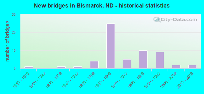
- New bridges - historical statistics
- 11910-1919
- 11930-1939
- 11940-1949
- 41950-1959
- 251960-1969
- 51970-1979
- 101980-1989
- 91990-1999
- 22000-2009
- 22010-2019
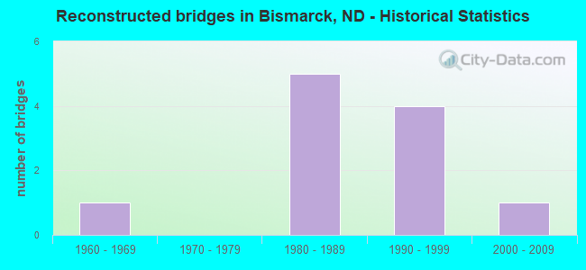
- Reconstructed bridges - Historical Statistics
- 11960-1969
- 01970-1979
- 51980-1989
- 41990-1999
- 12000-2009
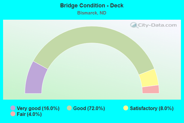
- Bridge Condition - Deck
- 16.0%Very good
- 72.0%Good
- 8.0%Satisfactory
- 4.0%Fair
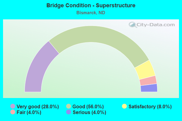
- Bridge Condition - Superstructure
- 28.0%Very good
- 56.0%Good
- 8.0%Satisfactory
- 4.0%Fair
- 4.0%Serious
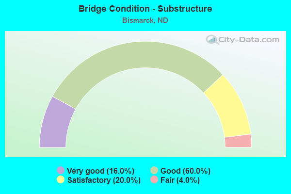
- Bridge Condition - Substructure
- 16.0%Very good
- 60.0%Good
- 20.0%Satisfactory
- 4.0%Fair

- Bridge Condition - Channel
- 15.4%Excellent
- 23.1%Very good
- 34.6%Good
- 15.4%Satisfactory
- 11.5%Fair
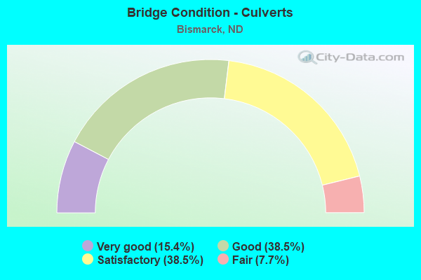
- Bridge Condition - Culverts
- 15.4%Very good
- 38.5%Good
- 38.5%Satisfactory
- 7.7%Fair
Find on map >> Show street view
Structure Number: 94158792 R, Location: 1 WEST OF US 83 NORTH (Lat: 46.831667, Lng: -100.785000), Route carried "under" structure: City street , Year Built: 1965, Structure Length: 0. m, Average Daily Traffic: 8,850 (year 2011), Truck Traffic: 11%, Features Intersected: 4TH STREET SEPARATION, Facility Carried by Structure: INTERSTATE 94
Minimum Vertical Clearance: 4.69m (15.39ft), Kilometerpoint: 0.000, Lanes on structure: 2, Lanes under structure: 2, Material/Design: Concrete continuous, Design/Construction: Tee Beam, Length of Maximum Span: 18.6m (61.0ft)
Find on map >> Show street view
Structure Number: 94159419, Location: JUNCTION OF US 83N & I-94 (Lat: 46.831403, Lng: -100.772967), Route carried "under" structure: Interstate 94, Year Built: 1965, Structure Length: 0. m, Average Daily Traffic: 17,700 (year 2011), Truck Traffic: 11%, Features Intersected: I-94/STATE STREET INT, Facility Carried by Structure: US HIGHWAY
Minimum Vertical Clearance: 5.02m (16.47ft), Kilometerpoint: 256.560, Lanes on structure: 4, Lanes under structure: 2, Material/Design: Prestressed concrete continuous, Design/Construction: Stringer/Multi-beam, Length of Maximum Span: 21.0m (68.9ft)
Find on map >> Show street view
Structure Number: 94159419, Location: JUNCTION OF US 83N & I-94 (Lat: 46.831403, Lng: -100.772967), Route carried "under" structure: Interstate 94, Year Built: 1965, Structure Length: 0. m, Average Daily Traffic: 17,700 (year 2011), Truck Traffic: 11%, Features Intersected: I-94/STATE STREET INT, Facility Carried by Structure: US HIGHWAY
Minimum Vertical Clearance: 5.23m (17.16ft), Kilometerpoint: 256.560, Lanes on structure: 4, Lanes under structure: 2, Material/Design: Prestressed concrete continuous, Design/Construction: Stringer/Multi-beam, Length of Maximum Span: 21.0m (68.9ft)
Find on map >> Show street view
Structure Number: 94159926, Location: 1 EAST OF US 83 NORTH (Lat: 46.831481, Lng: -100.762358), Route carried "under" structure: Interstate 94, Year Built: 1976, Structure Length: 0. m, Average Daily Traffic: 12,300 (year 2011), Truck Traffic: 13%, Features Intersected: I-94/19TH STREET SEP, Facility Carried by Structure: CITY STREET
Minimum Vertical Clearance: 5.15m (16.90ft), Kilometerpoint: 257.376, Lanes on structure: 2, Lanes under structure: 2, Material/Design: Steel continuous, Design/Construction: Stringer/Multi-beam, Length of Maximum Span: 33.2m (108.9ft)
Find on map >> Show street view
Structure Number: 94159926, Location: 1 EAST OF US 83 NORTH (Lat: 46.831481, Lng: -100.762358), Route carried "under" structure: Interstate 94, Year Built: 1976, Structure Length: 0. m, Average Daily Traffic: 12,300 (year 2011), Truck Traffic: 13%, Features Intersected: I-94/19TH STREET SEP, Facility Carried by Structure: CITY STREET
Minimum Vertical Clearance: 5.01m (16.44ft), Kilometerpoint: 257.376, Lanes on structure: 2, Lanes under structure: 2, Material/Design: Steel continuous, Design/Construction: Stringer/Multi-beam, Length of Maximum Span: 33.2m (108.9ft)
Find on map >> Show street view
Structure Number: 94161439, Location: 2 EAST OF US 83 NORTH (Lat: 46.831375, Lng: -100.730542), Route carried "under" structure: Interstate 94, Year Built: 1964, Structure Length: 0. m, Average Daily Traffic: 7,700 (year 2011), Truck Traffic: 20%, Features Intersected: I-94/EAST BISMARCK INT, Facility Carried by Structure: BIS EXPWY/CENT DR
Minimum Vertical Clearance: 5.11m (16.77ft), Kilometerpoint: 259.811, Lanes on structure: 5, Lanes under structure: 2, Material/Design: Prestressed concrete continuous, Design/Construction: Stringer/Multi-beam, Length of Maximum Span: 19.8m (65.0ft)
Find on map >> Show street view
Structure Number: 94161439, Location: 2 EAST OF US 83 NORTH (Lat: 46.831375, Lng: -100.730542), Route carried "under" structure: Interstate 94, Year Built: 1964, Structure Length: 0. m, Average Daily Traffic: 7,700 (year 2011), Truck Traffic: 20%, Features Intersected: I-94/EAST BISMARCK INT, Facility Carried by Structure: BIS EXPWY/CENT DR
Minimum Vertical Clearance: 5.46m (17.91ft), Kilometerpoint: 259.811, Lanes on structure: 5, Lanes under structure: 2, Material/Design: Prestressed concrete continuous, Design/Construction: Stringer/Multi-beam, Length of Maximum Span: 19.8m (65.0ft)
Find on map >> Show street view
Structure Number: 94164527, Location: 5 EAST OF US 83 NORTH (Lat: 46.838575, Lng: -100.667456), Route carried "under" structure: Interstate 94, Year Built: 1965, Structure Length: 0. m, Average Daily Traffic: 7,700 (year 2011), Truck Traffic: 20%, Features Intersected: GIBBS TWP SEPARATION
Minimum Vertical Clearance: 4.87m (15.98ft), Kilometerpoint: 264.781, Lanes on structure: 2, Lanes under structure: 2, Material/Design: Steel continuous, Design/Construction: Stringer/Multi-beam, Length of Maximum Span: 20.1m (65.9ft)
Find on map >> Show street view
Structure Number: 94164527, Location: 5 EAST OF US 83 NORTH (Lat: 46.838575, Lng: -100.667456), Route carried "under" structure: Interstate 94, Year Built: 1965, Structure Length: 0. m, Average Daily Traffic: 7,700 (year 2011), Truck Traffic: 20%, Features Intersected: GIBBS TWP SEPARATION
Minimum Vertical Clearance: 4.86m (15.94ft), Kilometerpoint: 264.781, Lanes on structure: 2, Lanes under structure: 2, Material/Design: Steel continuous, Design/Construction: Stringer/Multi-beam, Length of Maximum Span: 20.1m (65.9ft)
Find on map >> Show street view
Structure Number: 94921505 B, Location: WEST BISMARCK (Lat: 46.808911, Lng: -100.807150), Route carried "under" structure: Business State highway 94, Year Built: 1959, Structure Length: 0. m, Average Daily Traffic: 13,100 (year 2011), Truck Traffic: 2%, Features Intersected: PED WALK-MEMORIAL HWY, Facility Carried by Structure: PEDESTRIAN WALKWAY
Minimum Vertical Clearance: 4.65m (15.26ft), Kilometerpoint: 1483.019, Lanes under structure: 2, Material/Design: Steel, Design/Construction: Stringer/Multi-beam, Length of Maximum Span: 24.4m (80.1ft)
Find on map >> Show street view
Structure Number: 94921505 B, Location: WEST BISMARCK (Lat: 46.808911, Lng: -100.807150), Route carried "under" structure: Business State highway 94, Year Built: 1959, Structure Length: 0. m, Average Daily Traffic: 13,100 (year 2011), Truck Traffic: 2%, Features Intersected: PED WALK-MEMORIAL HWY, Facility Carried by Structure: PEDESTRIAN WALKWAY
Minimum Vertical Clearance: 4.67m (15.32ft), Kilometerpoint: 1483.019, Lanes under structure: 2, Material/Design: Steel, Design/Construction: Stringer/Multi-beam, Length of Maximum Span: 24.4m (80.1ft)
Find on map >> Show street view
Structure Number: 94921583 B, Location: BISMARCK (Lat: 46.808900, Lng: -100.805422), Route carried "under" structure: Business State highway 94, Year Built: 1959, Structure Length: 0. m, Average Daily Traffic: 13,340 (year 2011), Truck Traffic: 2%, Features Intersected: BNRR SEPARATION UP, Facility Carried by Structure: BNRR
Minimum Vertical Clearance: 4.57m (14.99ft), Kilometerpoint: 1483.144, Lanes under structure: 2, Material/Design: Steel, Design/Construction: Stringer/Multi-beam, Length of Maximum Span: 8.5m (27.9ft)
Find on map >> Show street view
Structure Number: 94921583 B, Location: BISMARCK (Lat: 46.808900, Lng: -100.805422), Route carried "under" structure: Business State highway 94, Year Built: 1959, Structure Length: 0. m, Average Daily Traffic: 13,340 (year 2011), Truck Traffic: 3%, Features Intersected: BNRR SEPARATION UP, Facility Carried by Structure: BNRR
Minimum Vertical Clearance: 4.63m (15.19ft), Kilometerpoint: 1483.144, Lanes under structure: 2, Material/Design: Steel, Design/Construction: Stringer/Multi-beam, Length of Maximum Span: 8.5m (27.9ft)
Find on map >> Show street view
Structure Number: 94922121, Location: WEST MAIN & WASHINGTON ST (Lat: 46.806667, Lng: -100.793333), Route carried "under" structure: City street , Year Built: 1993, Structure Length: 0. m, Average Daily Traffic: 200 (year 2011), Truck Traffic: 4%, Features Intersected: WASHINGTON STREET, Facility Carried by Structure: I-94 BUS LP BISMAR
Minimum Vertical Clearance: 4.58m (15.03ft), Kilometerpoint: 0.000, Lanes on structure: 4, Lanes under structure: 2, Material/Design: Prestressed concrete continuous, Design/Construction: Box Beam or Girders - Single/Spread, Length of Maximum Span: 20.4m (66.9ft)