Bridge Statistics for Bloomfield, New Jersey (NJ)
Condition, Traffic, Stress, Structural Evaluation, Project Costs
- National Bridge Inventory (NBI) Statistics
- 55Number of bridges
- 433ft / 132mTotal length
- $38,065,000Total costs
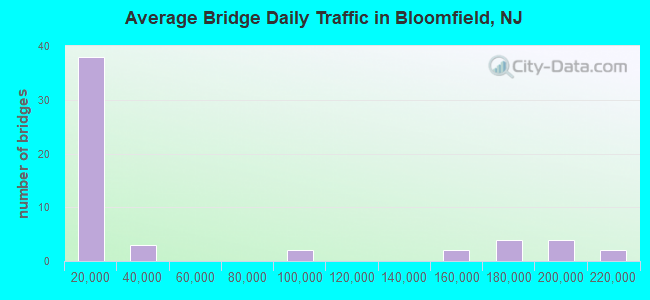
- 2,784,434Total average daily traffic
- 36,090Total average daily truck traffic
- National Bridge Inventory (NBI) Registered Bridges for Bloomfield
- No street view available for this location
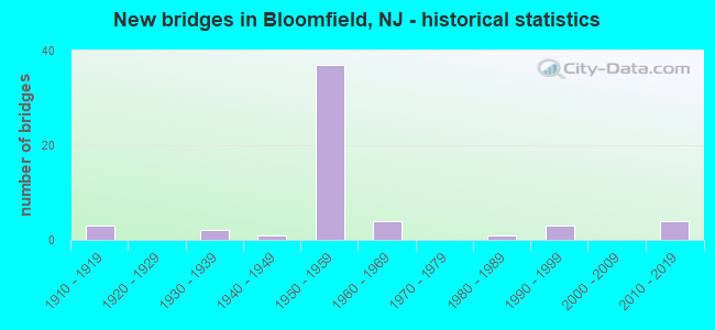
- New bridges - historical statistics
- 31910-1919
- 21930-1939
- 11940-1949
- 371950-1959
- 41960-1969
- 11980-1989
- 31990-1999
- 42010-2019
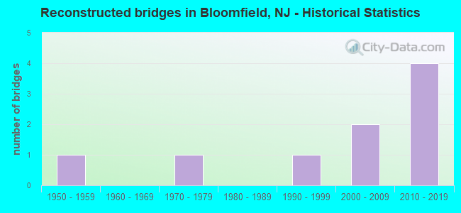
- Reconstructed bridges - Historical Statistics
- 11950-1959
- 01960-1969
- 11970-1979
- 01980-1989
- 11990-1999
- 22000-2009
- 42010-2019
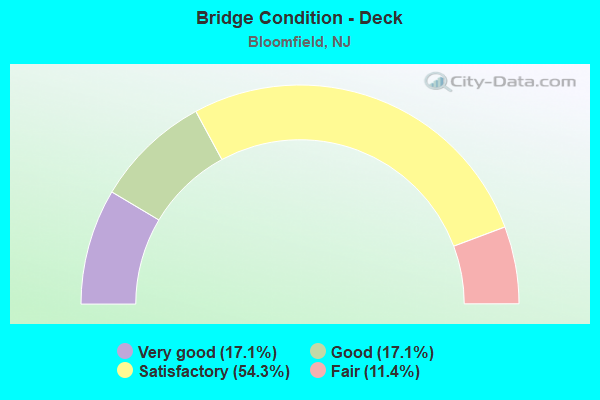
- Bridge Condition - Deck
- 17.1%Very good
- 17.1%Good
- 54.3%Satisfactory
- 11.4%Fair
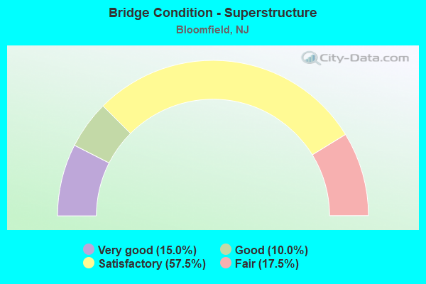
- Bridge Condition - Superstructure
- 15.0%Very good
- 10.0%Good
- 57.5%Satisfactory
- 17.5%Fair
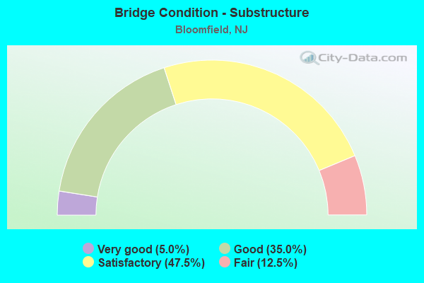
- Bridge Condition - Substructure
- 5.0%Very good
- 35.0%Good
- 47.5%Satisfactory
- 12.5%Fair
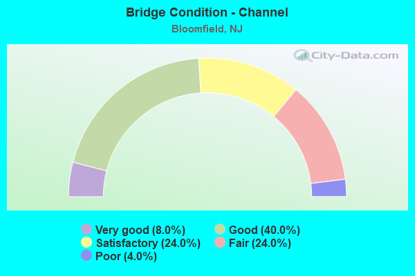
- Bridge Condition - Channel
- 8.0%Very good
- 40.0%Good
- 24.0%Satisfactory
- 24.0%Fair
- 4.0%Poor
Find on map >> Show street view
Structure Number: 361531A, Location: 1 MI S OF GSP & RT3 JCT (Lat: 40.838622, Lng: -74.178964), Route carried "on" structure: Ramp Other road GSP, Year Built: 1954, Status: Open, Structure Length: 1.92m (6.30ft), Average Daily Traffic: 4,142 (year 2020), Truck Traffic: 1%, Average Future Daily Traffic: 5,054 (year 2040), Design Load: H 20, Features Intersected: THIRD RIVER, Facility Carried by Structure: NB ENT FR SER AREA
Minimum Vertical Clearance: 30+ m (98+ ft), Kilometerpoint: 246.391, Lanes on structure: 1, Toll: On toll road, Owner: State Toll Authority, Approaching Roadway Width: 6.7m (22.0ft), Skew: 4 degrees, Material/Design: Steel, Design/Construction: Stringer/Multi-beam, Number Of Spans In Main Unit: 1, Length of Maximum Span: 17.7m (58.1ft), Curb-To-Curb Width: 5.5m (18.0ft), Out-to-Out Width: 7.6m (24.9ft)
Condition: Deck: Satisfactory, Superstructure: Satisfactory, Substructure: Satisfactory, Channel: Fair, Operating Rating: 56.7 metric tons, Method Used To Determine Operating Rating: Load and Resistance Factor Rating (LRFR) rating reported by rating factor(RF) method using HL-93 loadings, Inventory Rating: 43.7 metric tons, Method Used To Determine Inventory Rating: Load and Resistance Factor Rating (LRFR) rating reported by rating factor(RF) method using HL-93 loadings, Structural Evaluation: Equal to present minimum criteria, Deck Geometry: Meets minimum limits, Waterway Adequacy: Better than present minimum criteria, Approach Roadway Alignment: Equal to present desirable criteria, Designated Inspection Frequency: Every 24 months, Critical Feature Inspection Frequency: Every 24 months, Inspection Date: March 2020, Critical Feature Inspection Date: March 2020, Deck Structure Type: Concrete Cast-file-Place, Wearing Surface/Protective System: Wearing Surface: Bituminous, Membrane: Preformed Fabric
Find on map >> Show street view
Structure Number: 361531N, Location: 1 MI S OF GSP & RT 3 JCT (Lat: 40.838269, Lng: -74.179483), Route carried "on" structure: Other road GSP, Year Built: 1954, Year Reconstructed: 2017, Status: Open, Structure Length: 1.68m (5.51ft), Average Daily Traffic: 96,195 (year 2020), Truck Traffic: 1%, Average Future Daily Traffic: 115,475 (year 2040), Design Load: HL 93, Features Intersected: THIRD RIVER, Facility Carried by Structure: GARDEN ST PKWY NB
Minimum Vertical Clearance: 30+ m (98+ ft), Kilometerpoint: 246.391, Lanes on structure: 3, Base Highway Network: Yes, Toll: On toll road, Owner: State Toll Authority, Approaching Roadway Width: 15.5m (50.9ft), Skew: 3 degrees, Material/Design: Steel, Design/Construction: Stringer/Multi-beam, Number Of Spans In Main Unit: 1, Length of Maximum Span: 15.5m (50.9ft), Curb-To-Curb Width: 15.5m (50.9ft), Out-to-Out Width: 16.6m (54.5ft)
Condition: Deck: Very good, Superstructure: Very good, Substructure: Good, Channel: Good, Operating Rating: 96.9 metric tons, Method Used To Determine Operating Rating: Load and Resistance Factor Rating (LRFR) rating reported by rating factor(RF) method using HL-93 loadings, Inventory Rating: 76.5 metric tons, Method Used To Determine Inventory Rating: Load and Resistance Factor Rating (LRFR) rating reported by rating factor(RF) method using HL-93 loadings, Structural Evaluation: Better than present minimum criteria, Deck Geometry: Somewhat better than minimum adequacy, Waterway Adequacy: Better than present minimum criteria, Approach Roadway Alignment: Equal to present desirable criteria, Designated Inspection Frequency: Every 24 months, Inspection Date: March 2020, Deck Structure Type: Concrete Precast Panels, Wearing Surface/Protective System: Wearing Surface: Monolithic Concrete, Deck Protection: Epoxy Coated Reinforcing
Find on map >> Show street view
Structure Number: 700081, Location: 0.1 mi east of Rt 509 (Lat: 40.806231, Lng: -74.191911), Route carried "under" structure: County highway 652, Year Built: 1955, Structure Length: 0. m, Average Daily Traffic: 9,635 (year 2021), Truck Traffic: 4%, Features Intersected: JFK Drive (CR 652), Facility Carried by Structure: James Street
Minimum Vertical Clearance: 4.32m (14.17ft), Kilometerpoint: 0.772, Lanes on structure: 2, Lanes under structure: 2, Material/Design: Steel, Design/Construction: Stringer/Multi-beam, Length of Maximum Span: 8.5m (27.9ft)
Find on map >> Show street view
Structure Number: 700082, Location: 0.1 mi east of RT 509 (Lat: 40.807181, Lng: -74.191689), Route carried "under" structure: County highway 652, Year Built: 1956, Structure Length: 0. m, Average Daily Traffic: 15,612 (year 2021), Truck Traffic: 4%, Features Intersected: JFK Drive (CR 652), Facility Carried by Structure: Baldwin Street
Minimum Vertical Clearance: 4.40m (14.44ft), Kilometerpoint: 0.869, Lanes on structure: 2, Lanes under structure: 2, Material/Design: Steel, Design/Construction: Stringer/Multi-beam, Length of Maximum Span: 10.1m (33.1ft)
Find on map >> Show street view
Structure Number: 361488T, Location: 1.7 MILES NORTH OF I280 (Lat: 40.781786, Lng: -74.201506), Route carried "under" structure: City street , Year Built: 1954, Structure Length: 0. m, Average Daily Traffic: 6,873 (year 2021), Truck Traffic: 4%, Features Intersected: DODD ST, Facility Carried by Structure: GSP
Minimum Vertical Clearance: 4.67m (15.32ft), Kilometerpoint: 2.012, Lanes on structure: 8, Lanes under structure: 2, Material/Design: Steel, Design/Construction: Stringer/Multi-beam, Length of Maximum Span: 16.8m (55.1ft)
Find on map >> Show street view
Structure Number: 361489T, Location: 1.8 MILES NORTH OF I280 (Lat: 40.783678, Lng: -74.201133), Route carried "under" structure: City street , Year Built: 1954, Structure Length: 0. m, Average Daily Traffic: 3,564 (year 2021), Truck Traffic: 1%, Features Intersected: MYRTLE STREET, Facility Carried by Structure: GSP
Minimum Vertical Clearance: 4.78m (15.68ft), Kilometerpoint: 0.000, Lanes on structure: 11, Lanes under structure: 2, Material/Design: Steel, Design/Construction: Stringer/Multi-beam, Length of Maximum Span: 16.5m (54.1ft)
Find on map >> Show street view
Structure Number: 361491A, Location: 2 MI N OF GSP&RT280 JCT (Lat: 40.787025, Lng: -74.199578), Route carried "under" structure: City street , Year Built: 1964, Structure Length: 0. m, Average Daily Traffic: 6,630 (year 2020), Features Intersected: JFK Dr. SB & NJ TRANSIT, Facility Carried by Structure: GSP SB ENTR. RAMP
Minimum Vertical Clearance: 6.73m (22.08ft), Kilometerpoint: 1.416, Lanes on structure: 1, Lanes under structure: 1, Material/Design: Concrete, Design/Construction: Slab, Length of Maximum Span: 50.6m (166.0ft)
Find on map >> Show street view
Structure Number: 361494T, Location: 2.4 MILES NORTH OF I280 (Lat: 40.789550, Lng: -74.195419), Route carried "under" structure: County highway 506, Year Built: 1954, Structure Length: 0. m, Average Daily Traffic: 20,191 (year 2020), Truck Traffic: 4%, Features Intersected: CR509,CR506,SECOND RIVER, Facility Carried by Structure: GSP
Minimum Vertical Clearance: 5.08m (16.67ft), Kilometerpoint: 1.819, Lanes on structure: 6, Lanes under structure: 4, Material/Design: Steel, Design/Construction: Stringer/Multi-beam, Length of Maximum Span: 28.7m (94.2ft)
Find on map >> Show street view
Structure Number: 361494T, Location: 2.4 MILES NORTH OF I280 (Lat: 40.789550, Lng: -74.195419), Route carried "under" structure: County highway , Year Built: 1954, Structure Length: 0. m, Average Daily Traffic: 8,570 (year 2020), Truck Traffic: 4%, Features Intersected: CR509,CR506,SECOND RIVER, Facility Carried by Structure: GSP
Minimum Vertical Clearance: 4.82m (15.81ft), Kilometerpoint: 24.929, Lanes on structure: 6, Lanes under structure: 2, Material/Design: Steel, Design/Construction: Stringer/Multi-beam, Length of Maximum Span: 28.7m (94.2ft)
Find on map >> Show street view
Structure Number: 361494T, Location: 2.4 MILES NORTH OF I280 (Lat: 40.789550, Lng: -74.195419), Route carried "under" structure: Ramp City street , Year Built: 1954, Structure Length: 0. m, Average Daily Traffic: 7,855 (year 2020), Truck Traffic: 1%, Features Intersected: CR509,CR506,SECOND RIVER, Facility Carried by Structure: GSP
Minimum Vertical Clearance: 4.06m (13.32ft), Kilometerpoint: 0.000, Lanes on structure: 6, Lanes under structure: 1, Material/Design: Steel, Design/Construction: Stringer/Multi-beam, Length of Maximum Span: 28.7m (94.2ft)
Find on map >> Show street view
Structure Number: 361497T, Location: 2.5 MI N OF GSP&I280 JCT (Lat: 40.792311, Lng: -74.192581), Route carried "under" structure: Other road GSP, Year Built: 1954, Structure Length: 0. m, Average Daily Traffic: 165,685 (year 2020), Truck Traffic: 1%, Features Intersected: GARDEN STATE PARKWAY, Facility Carried by Structure: MONTGOMERY STREET
Minimum Vertical Clearance: 4.80m (15.75ft), Kilometerpoint: 240.935, Lanes on structure: 2, Lanes under structure: 6, Toll: On toll road, Material/Design: Steel, Design/Construction: Stringer/Multi-beam, Length of Maximum Span: 18.3m (60.0ft)
Find on map >> Show street view
Structure Number: 361499T, Location: 2.75 MI NE OF GSP&I280 JC (Lat: 40.795292, Lng: -74.191800), Route carried "under" structure: Other road GSP, Year Built: 1954, Structure Length: 0. m, Average Daily Traffic: 214,940 (year 2020), Truck Traffic: 1%, Features Intersected: GARDEN STATE PARKWAY, Facility Carried by Structure: LIBERTY STREET
Minimum Vertical Clearance: 4.42m (14.50ft), Kilometerpoint: 241.257, Lanes on structure: 3, Lanes under structure: 7, Toll: On toll road, Material/Design: Steel, Design/Construction: Stringer/Multi-beam, Length of Maximum Span: 17.4m (57.1ft)
Find on map >> Show street view
Structure Number: 361502T, Location: 3 MI NE OF GSP&I-280 JCT (Lat: 40.799161, Lng: -74.188967), Route carried "under" structure: Other road GSP, Year Built: 1954, Structure Length: 0. m, Average Daily Traffic: 163,150 (year 2020), Truck Traffic: 1%, Features Intersected: GARDEN STATE PARKWAY, Facility Carried by Structure: BELLEVILLE AVE
Minimum Vertical Clearance: 4.93m (16.17ft), Kilometerpoint: 241.756, Lanes on structure: 2, Lanes under structure: 7, Material/Design: Steel, Design/Construction: Stringer/Multi-beam, Length of Maximum Span: 19.5m (64.0ft)
Find on map >> Show street view
Structure Number: 361511T, Location: 4.0 MILES NORTH OF I280 (Lat: 40.810150, Lng: -74.180819), Route carried "under" structure: City street 651, Year Built: 1954, Structure Length: 0. m, Average Daily Traffic: 13,055 (year 2020), Truck Traffic: 3%, Features Intersected: HOOVER AVE (CR 651), Facility Carried by Structure: GARDEN ST PARKWAY
Minimum Vertical Clearance: 4.57m (14.99ft), Kilometerpoint: 0.499, Lanes on structure: 6, Lanes under structure: 2, Material/Design: Steel, Design/Construction: Stringer/Multi-beam, Length of Maximum Span: 17.4m (57.1ft)
Find on map >> Show street view
Structure Number: 361524T, Location: 1.75 MI S OF GSP&RT3 JCT (Lat: 40.828619, Lng: -74.177239), Route carried "under" structure: Other road GSP, Year Built: 2012, Structure Length: 0. m, Average Daily Traffic: 159,136 (year 2020), Truck Traffic: 1%, Features Intersected: GARDEN STATE PARKWAY, Facility Carried by Structure: WATCHUNG AVENUE
Minimum Vertical Clearance: 5.18m (16.99ft), Kilometerpoint: 245.344, Lanes on structure: 4, Lanes under structure: 6, Toll: On toll road, Material/Design: Steel continuous, Design/Construction: Stringer/Multi-beam, Length of Maximum Span: 42.1m (138.1ft)
Find on map >> Show street view
Structure Number: 361528T, Location: 5.7 MILES NORTH OF I280 (Lat: 40.833581, Lng: -74.179622), Route carried "under" structure: Other road GSP, Year Built: 1953, Structure Length: 0. m, Average Daily Traffic: 158,365 (year 2020), Truck Traffic: 1%, Features Intersected: GARDEN STATE PARKWAY, Facility Carried by Structure: WEST PASSAIC AVE
Minimum Vertical Clearance: 5.08m (16.67ft), Kilometerpoint: 245.956, Lanes on structure: 3, Lanes under structure: 8, Toll: On toll road, Material/Design: Steel, Design/Construction: Stringer/Multi-beam, Length of Maximum Span: 27.7m (90.9ft)