Bridge Statistics for Bloomington, Indiana (IN)
Condition, Traffic, Stress, Structural Evaluation, Project Costs
- National Bridge Inventory (NBI) Statistics
- 137Number of bridges
- 1,066ft / 325mTotal length
- $7,496,000Total costs
- 1,374,603Total average daily traffic
- 172,417Total average daily truck traffic
- National Bridge Inventory (NBI) Registered Bridges for Bloomington
- No street view available for this location
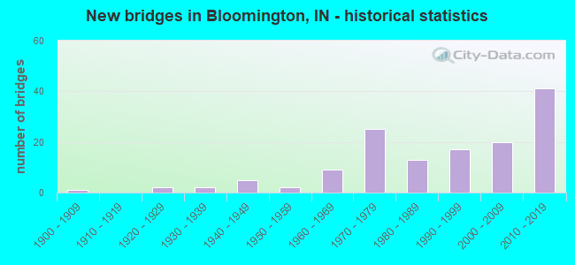
- New bridges - historical statistics
- 11900-1909
- 21920-1929
- 21930-1939
- 51940-1949
- 21950-1959
- 91960-1969
- 251970-1979
- 131980-1989
- 171990-1999
- 202000-2009
- 412010-2019
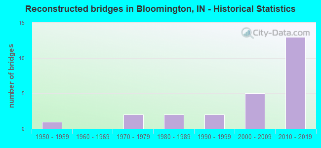
- Reconstructed bridges - Historical Statistics
- 11950-1959
- 01960-1969
- 21970-1979
- 21980-1989
- 21990-1999
- 52000-2009
- 132010-2019
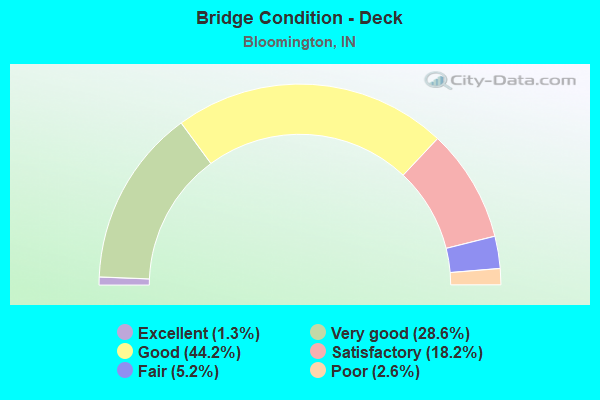
- Bridge Condition - Deck
- 1.3%Excellent
- 28.6%Very good
- 44.2%Good
- 18.2%Satisfactory
- 5.2%Fair
- 2.6%Poor
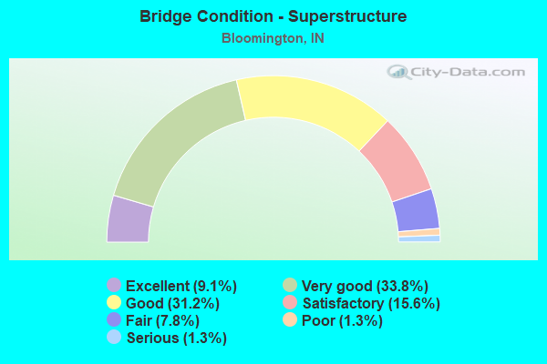
- Bridge Condition - Superstructure
- 9.1%Excellent
- 33.8%Very good
- 31.2%Good
- 15.6%Satisfactory
- 7.8%Fair
- 1.3%Poor
- 1.3%Serious
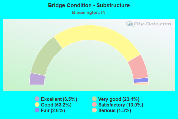
- Bridge Condition - Substructure
- 6.5%Excellent
- 23.4%Very good
- 53.2%Good
- 13.0%Satisfactory
- 2.6%Fair
- 1.3%Serious
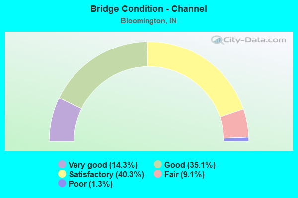
- Bridge Condition - Channel
- 14.3%Very good
- 35.1%Good
- 40.3%Satisfactory
- 9.1%Fair
- 1.3%Poor
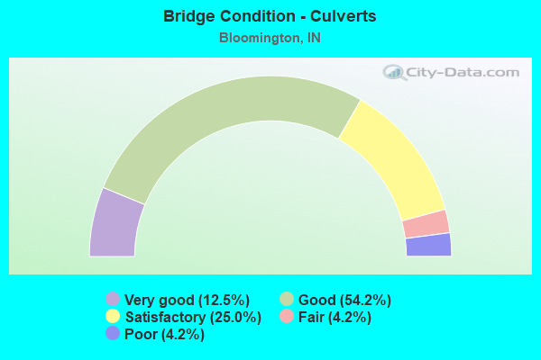
- Bridge Condition - Culverts
- 12.5%Very good
- 54.2%Good
- 25.0%Satisfactory
- 4.2%Fair
- 4.2%Poor
Find on map >> Show street view
Structure Number: 5300143, Location: 00.10 W SNODDY ROAD (Lat: 39.135850, Lng: -86.491611), Route carried "on" structure: City street , Year Built: 1994, Status: Open, Structure Length: 0.88m (2.89ft), Average Daily Traffic: 5,251 (year 2014), Truck Traffic: 5%, Average Future Daily Traffic: 9,410 (year 2034), Features Intersected: E FORK JACKSON CREEK, Facility Carried by Structure: ROGERS ROAD
Minimum Vertical Clearance: 30+ m (98+ ft), Kilometerpoint: 0.000, Lanes on structure: 2, Owner: County Highway Agency, Approaching Roadway Width: 5.8m (19.0ft), Skew: 3 degrees, Material/Design: Aluminum, Iron, Design/Construction: Culvert, Number Of Spans In Main Unit: 2, Length of Maximum Span: 4.1m (13.5ft), Curb-To-Curb Width: 9.0m (29.5ft), Out-to-Out Width: 9.0m (29.5ft)
Condition: Channel: Satisfactory, Culverts: Good, Inventory Rating: 80.3 metric tons, Method Used To Determine Inventory Rating: Field evaluation and documented engineering judgment, Structural Evaluation: Better than present minimum criteria, Deck Geometry: High priority of replacement, Waterway Adequacy: Better than present minimum criteria, Approach Roadway Alignment: Equal to present desirable criteria, Designated Inspection Frequency: Every 24 months, Inspection Date: March 2020
Find on map >> Show street view
Structure Number: 5300144, Location: 00.20 E OLD US 37 N (Lat: 39.239019, Lng: -86.495069), Route carried "on" structure: County highway , Year Built: 2001, Status: Open, Structure Length: 0.61m (2.00ft), Average Daily Traffic: 819 (year 2014), Truck Traffic: 5%, Average Future Daily Traffic: 1,468 (year 2034), Features Intersected: MUDDY FORK, Facility Carried by Structure: BOULTINGHOUSE ROAD
Minimum Vertical Clearance: 30+ m (98+ ft), Kilometerpoint: 0.000, Lanes on structure: 2, Owner: County Highway Agency, Approaching Roadway Width: 5.8m (19.0ft), Material/Design: Concrete, Design/Construction: Culvert, Number Of Spans In Main Unit: 1, Length of Maximum Span: 6.1m (20.0ft), Curb-To-Curb Width: 5.8m (19.0ft), Out-to-Out Width: 5.8m (19.0ft)
Condition: Channel: Satisfactory, Culverts: Good, Operating Rating: 54.5 metric tons, Method Used To Determine Operating Rating: Field evaluation and documented engineering judgment, Inventory Rating: 32.7 metric tons, Method Used To Determine Inventory Rating: Field evaluation and documented engineering judgment, Structural Evaluation: Better than present minimum criteria, Deck Geometry: High priority of replacement, Waterway Adequacy: Equal to present minimum criteria, Approach Roadway Alignment: Equal to present desirable criteria, Designated Inspection Frequency: Every 24 months, Inspection Date: March 2020
Find on map >> Show street view
Structure Number: 5300145, Location: 01.50 NE SR 46 (Lat: 39.175461, Lng: -86.440269), Route carried "on" structure: County highway , Year Built: 2001, Year Reconstructed: 2015, Status: Open, Structure Length: 0.86m (2.82ft), Average Daily Traffic: 69 (year 2014), Average Future Daily Traffic: 124 (year 2034), Features Intersected: KERR CREEK, Facility Carried by Structure: KERR CREEK ROAD
Minimum Vertical Clearance: 30+ m (98+ ft), Kilometerpoint: 0.000, Lanes on structure: 2, Owner: County Highway Agency, Approaching Roadway Width: 7.0m (23.0ft), Skew: 4 degrees, Material/Design: Concrete, Design/Construction: Culvert, Number Of Spans In Main Unit: 1, Length of Maximum Span: 8.6m (28.2ft), Curb-To-Curb Width: 7.0m (23.0ft), Out-to-Out Width: 7.0m (23.0ft)
Condition: Channel: Satisfactory, Culverts: Satisfactory, Operating Rating: 54.2 metric tons, Method Used To Determine Operating Rating: Field evaluation and documented engineering judgment, Inventory Rating: 32.7 metric tons, Method Used To Determine Inventory Rating: Field evaluation and documented engineering judgment, Structural Evaluation: Equal to present minimum criteria, Deck Geometry: Somewhat better than minimum adequacy, Waterway Adequacy: Equal to present minimum criteria, Approach Roadway Alignment: Equal to present minimum criteria, Designated Inspection Frequency: Every 24 months, Inspection Date: March 2020
Find on map >> Show street view
Structure Number: 5300146, Location: 0.2 MILE SW OF CURRY PIKE (Lat: 39.154839, Lng: -86.585989), Route carried "on" structure: City street , Year Built: 2000, Status: Open, Structure Length: 0.63m (2.07ft), Average Daily Traffic: 2,943 (year 2014), Truck Traffic: 5%, Average Future Daily Traffic: 5,274 (year 2034), Features Intersected: SINKING CREEK, Facility Carried by Structure: GIFFORD ROAD
Minimum Vertical Clearance: 30+ m (98+ ft), Kilometerpoint: 0.000, Lanes on structure: 2, Owner: County Highway Agency, Approaching Roadway Width: 7.0m (23.0ft), Skew: 1 degrees, Material/Design: Concrete, Design/Construction: Culvert, Number Of Spans In Main Unit: 1, Length of Maximum Span: 6.3m (20.7ft), Curb-To-Curb Width: 7.0m (23.0ft), Out-to-Out Width: 7.0m (23.0ft)
Condition: Channel: Good, Culverts: Satisfactory, Operating Rating: 54.5 metric tons, Method Used To Determine Operating Rating: Field evaluation and documented engineering judgment, Inventory Rating: 32.7 metric tons, Method Used To Determine Inventory Rating: Field evaluation and documented engineering judgment, Structural Evaluation: Equal to present minimum criteria, Deck Geometry: High priority of replacement, Waterway Adequacy: Better than present minimum criteria, Approach Roadway Alignment: Equal to present desirable criteria, Designated Inspection Frequency: Every 24 months, Inspection Date: March 2020
Find on map >> Show street view
Structure Number: 5300147, Location: 00.80 E WALNUT STREET (Lat: 39.121461, Lng: -86.510839), Route carried "on" structure: City street , Year Built: 2001, Status: Open, Structure Length: 0.67m (2.20ft), Average Daily Traffic: 3,429 (year 2014), Truck Traffic: 5%, Average Future Daily Traffic: 6,145 (year 2034), Design Load: HS 20, Features Intersected: JACKSON CREEK, Facility Carried by Structure: RHORER ROAD
Minimum Vertical Clearance: 30+ m (98+ ft), Kilometerpoint: 0.000, Lanes on structure: 2, Owner: County Highway Agency, Approaching Roadway Width: 7.6m (24.9ft), Skew: 2 degrees, Material/Design: Concrete, Design/Construction: Culvert, Number Of Spans In Main Unit: 1, Length of Maximum Span: 6.7m (22.0ft), Curb-To-Curb Width: 11.9m (39.0ft), Out-to-Out Width: 11.9m (39.0ft)
Condition: Channel: Fair, Culverts: Very good, Operating Rating: 54.5 metric tons, Method Used To Determine Operating Rating: Field evaluation and documented engineering judgment, Inventory Rating: 32.7 metric tons, Method Used To Determine Inventory Rating: Field evaluation and documented engineering judgment, Structural Evaluation: Equal to present desirable criteria, Deck Geometry: Somewhat better than minimum adequacy, Waterway Adequacy: Better than present minimum criteria, Approach Roadway Alignment: Equal to present desirable criteria, Length Of Structure Improvement: 1.43m (4.69ft), Designated Inspection Frequency: Every 24 months, Inspection Date: March 2020, Bridge Improvement Cost: $90,000, Roadway Improvement Cost: $50,000, Total Project Cost: $140,000 ( Estimate for 2020)
Find on map >> Show street view
Structure Number: 5300148, Location: 00.60 NW OF SWARTZ ROAD (Lat: 39.114600, Lng: -86.469681), Route carried "on" structure: County highway , Year Built: 2000, Status: Open, Structure Length: 1.34m (4.40ft), Average Daily Traffic: 411 (year 2014), Truck Traffic: 5%, Average Future Daily Traffic: 737 (year 2034), Features Intersected: MOORE CREEK, Facility Carried by Structure: MOORES CREEK ROAD
Minimum Vertical Clearance: 30+ m (98+ ft), Kilometerpoint: 0.000, Lanes on structure: 2, Owner: County Highway Agency, Approaching Roadway Width: 8.5m (27.9ft), Skew: 4 degrees, Material/Design: Prestressed concrete, Design/Construction: Box Beam or Girders - Multiple, Number Of Spans In Main Unit: 1, Length of Maximum Span: 13.1m (43.0ft), Curb-To-Curb Width: 8.5m (27.9ft), Out-to-Out Width: 8.5m (27.9ft)
Condition: Deck: Good, Superstructure: Good, Substructure: Good, Channel: Good, Operating Rating: 54.5 metric tons, Method Used To Determine Operating Rating: Field evaluation and documented engineering judgment, Inventory Rating: 32.7 metric tons, Method Used To Determine Inventory Rating: Field evaluation and documented engineering judgment, Structural Evaluation: Better than present minimum criteria, Deck Geometry: Somewhat better than minimum adequacy, Waterway Adequacy: Somewhat better than minimum adequacy, Approach Roadway Alignment: Equal to present desirable criteria, Designated Inspection Frequency: Every 24 months, Inspection Date: March 2020, Deck Structure Type: Concrete Precast Panels, Wearing Surface/Protective System: Wearing Surface: Bituminous
Find on map >> Show street view
Structure Number: 530015, Location: 00.10 S ALLEN STREET (Lat: 39.153900, Lng: -86.541611), Route carried "on" structure: City street , Year Built: 2001, Status: Open, Structure Length: 1.17m (3.84ft), Average Daily Traffic: 13,746 (year 2014), Truck Traffic: 5%, Average Future Daily Traffic: 24,633 (year 2034), Features Intersected: W BRANCH CLEAR CREEK, Facility Carried by Structure: PATTERSON DRIVE
Minimum Vertical Clearance: 30+ m (98+ ft), Kilometerpoint: 0.000, Lanes on structure: 2, Owner: County Highway Agency, Approaching Roadway Width: 9.4m (30.8ft), Skew: 2 degrees, Material/Design: Concrete, Design/Construction: Culvert, Number Of Spans In Main Unit: 1, Length of Maximum Span: 11.7m (38.4ft), Curb or Sidewalk Widths: Left: 1.8m (5.9ft), Right: 1.8m (5.9ft), Curb-To-Curb Width: 9.4m (30.8ft), Out-to-Out Width: 9.4m (30.8ft)
Condition: Channel: Satisfactory, Culverts: Good, Operating Rating: 54.9 metric tons, Method Used To Determine Operating Rating: Field evaluation and documented engineering judgment, Inventory Rating: 32.7 metric tons, Method Used To Determine Inventory Rating: Field evaluation and documented engineering judgment, Structural Evaluation: Better than present minimum criteria, Deck Geometry: High priority of corrective action, Waterway Adequacy: Better than present minimum criteria, Approach Roadway Alignment: Equal to present minimum criteria, Designated Inspection Frequency: Every 24 months, Inspection Date: March 2020
Find on map >> Show street view
Structure Number: 5300151, Location: 00.60 NW SR 37 (Lat: 39.200561, Lng: -86.560161), Route carried "on" structure: City street , Year Built: 1929, Year Reconstructed: 1961, Status: Open, Structure Length: 1.52m (4.99ft), Average Daily Traffic: 5,376 (year 2014), Truck Traffic: 5%, Average Future Daily Traffic: 9,634 (year 2034), Design Load: HS 20, Features Intersected: STOUT CREEK, Facility Carried by Structure: OLD SR 46
Minimum Vertical Clearance: 30+ m (98+ ft), Kilometerpoint: 0.000, Lanes on structure: 2, Owner: County Highway Agency, Approaching Roadway Width: 12.2m (40.0ft), Skew: 3 degrees, Material/Design: Concrete, Design/Construction: Culvert, Number Of Spans In Main Unit: 1, Length of Maximum Span: 15.2m (49.9ft), Curb-To-Curb Width: 12.5m (41.0ft), Out-to-Out Width: 13.4m (44.0ft)
Condition: Channel: Satisfactory, Culverts: Satisfactory, Operating Rating: 54.5 metric tons, Method Used To Determine Operating Rating: Field evaluation and documented engineering judgment, Inventory Rating: 32.7 metric tons, Method Used To Determine Inventory Rating: Field evaluation and documented engineering judgment, Structural Evaluation: Equal to present minimum criteria, Deck Geometry: Somewhat better than minimum adequacy, Waterway Adequacy: Equal to present desirable criteria, Approach Roadway Alignment: Equal to present desirable criteria, Designated Inspection Frequency: Every 24 months, Inspection Date: March 2020, Deck Structure Type: Concrete Cast-file-Place
Find on map >> Show street view
Structure Number: 5300152, Location: INT. N. GETTYS CREEK RD (Lat: 39.193339, Lng: -86.436478), Route carried "on" structure: County highway , Year Built: 2010, Status: Open, Structure Length: 1.55m (5.09ft), Average Daily Traffic: 312 (year 2014), Truck Traffic: 5%, Average Future Daily Traffic: 560 (year 2034), Design Load: HS 20, Features Intersected: BRANCH OF STEPHENS CREEK, Facility Carried by Structure: MT. GILEAD ROAD
Minimum Vertical Clearance: 30+ m (98+ ft), Kilometerpoint: 0.000, Lanes on structure: 2, Owner: County Highway Agency, Approaching Roadway Width: 6.1m (20.0ft), Material/Design: Prestressed concrete, Design/Construction: Box Beam or Girders - Multiple, Number Of Spans In Main Unit: 1, Length of Maximum Span: 15.2m (49.9ft), Curb-To-Curb Width: 8.4m (27.6ft), Out-to-Out Width: 8.6m (28.2ft)
Condition: Deck: Very good, Superstructure: Very good, Substructure: Very good, Channel: Very good, Operating Rating: 64.0 metric tons, Method Used To Determine Operating Rating: Load Factor (LF), Inventory Rating: 34.9 metric tons, Method Used To Determine Inventory Rating: Load Factor (LF), Structural Evaluation: Equal to present desirable criteria, Deck Geometry: Somewhat better than minimum adequacy, Waterway Adequacy: Equal to present desirable criteria, Approach Roadway Alignment: Equal to present minimum criteria, Designated Inspection Frequency: Every 48 months, Inspection Date: March 2018, Deck Structure Type: Concrete Cast-file-Place, Wearing Surface/Protective System: Wearing Surface: Monolithic Concrete, Deck Protection: Epoxy Coated Reinforcing
Find on map >> Show street view
Structure Number: 5300154, Location: 00.90 N SR 45 (Lat: 39.229639, Lng: -86.457361), Route carried "on" structure: County highway , Year Built: 1995, Status: Open, Structure Length: 0.74m (2.43ft), Average Daily Traffic: 1,084 (year 2014), Truck Traffic: 5%, Average Future Daily Traffic: 1,943 (year 2034), Features Intersected: MUDDY FORK, Facility Carried by Structure: EARL YOUNG ROAD
Minimum Vertical Clearance: 30+ m (98+ ft), Kilometerpoint: 0.000, Lanes on structure: 1, Owner: County Highway Agency, Approaching Roadway Width: 4.6m (15.1ft), Skew: 4 degrees, Material/Design: Aluminum, Iron, Design/Construction: Culvert, Number Of Spans In Main Unit: 1, Length of Maximum Span: 7.4m (24.3ft), Curb-To-Curb Width: 4.6m (15.1ft), Out-to-Out Width: 4.6m (15.1ft)
Condition: Channel: Satisfactory, Culverts: Good, Operating Rating: 54.5 metric tons, Method Used To Determine Operating Rating: Field evaluation and documented engineering judgment, Inventory Rating: 32.7 metric tons, Method Used To Determine Inventory Rating: Field evaluation and documented engineering judgment, Structural Evaluation: Better than present minimum criteria, Deck Geometry: High priority of replacement, Waterway Adequacy: Equal to present minimum criteria, Approach Roadway Alignment: High priority of corrective action, Designated Inspection Frequency: Every 24 months, Inspection Date: March 2020
Find on map >> Show street view
Structure Number: 5300158, Location: 01.00 S TAPP ROAD (Lat: 39.126600, Lng: -86.558219), Route carried "on" structure: County highway , Year Built: 1990, Status: Open, Structure Length: 1.05m (3.44ft), Average Daily Traffic: 5,626 (year 2014), Truck Traffic: 5%, Average Future Daily Traffic: 10,082 (year 2034), Features Intersected: BRANCH CLEAR CREEK, Facility Carried by Structure: ROCKPORT ROAD
Minimum Vertical Clearance: 30+ m (98+ ft), Kilometerpoint: 0.000, Lanes on structure: 2, Owner: County Highway Agency, Approaching Roadway Width: 5.8m (19.0ft), Skew: 3 degrees, Material/Design: Aluminum, Iron, Design/Construction: Culvert, Number Of Spans In Main Unit: 2, Length of Maximum Span: 4.9m (16.1ft), Curb-To-Curb Width: 7.7m (25.3ft), Out-to-Out Width: 7.7m (25.3ft)
Condition: Channel: Satisfactory, Culverts: Satisfactory, Operating Rating: 54.5 metric tons, Method Used To Determine Operating Rating: Field evaluation and documented engineering judgment, Inventory Rating: 32.7 metric tons, Method Used To Determine Inventory Rating: Field evaluation and documented engineering judgment, Structural Evaluation: Equal to present minimum criteria, Deck Geometry: High priority of replacement, Waterway Adequacy: Better than present minimum criteria, Approach Roadway Alignment: Equal to present desirable criteria, Designated Inspection Frequency: Every 24 months, Inspection Date: March 2020
Find on map >> Show street view
Structure Number: 5300159, Location: 00.25 S MAY ROAD (Lat: 39.090069, Lng: -86.588469), Route carried "on" structure: County highway , Year Built: 1987, Status: Open, Structure Length: 0.78m (2.56ft), Average Daily Traffic: 310 (year 2014), Truck Traffic: 5%, Average Future Daily Traffic: 556 (year 2034), Features Intersected: BRANCH CLEAR CREEK, Facility Carried by Structure: ROCKPORT ROAD
Minimum Vertical Clearance: 30+ m (98+ ft), Kilometerpoint: 0.000, Lanes on structure: 2, Owner: County Highway Agency, Approaching Roadway Width: 6.4m (21.0ft), Skew: 5 degrees, Material/Design: Aluminum, Iron, Design/Construction: Culvert, Number Of Spans In Main Unit: 1, Length of Maximum Span: 7.8m (25.6ft), Curb-To-Curb Width: 6.4m (21.0ft), Out-to-Out Width: 6.4m (21.0ft)
Condition: Channel: Good, Culverts: Good, Operating Rating: 54.5 metric tons, Method Used To Determine Operating Rating: Field evaluation and documented engineering judgment, Inventory Rating: 32.7 metric tons, Method Used To Determine Inventory Rating: Field evaluation and documented engineering judgment, Structural Evaluation: Better than present minimum criteria, Deck Geometry: Meets minimum limits, Waterway Adequacy: Equal to present desirable criteria, Approach Roadway Alignment: High priority of corrective action, Designated Inspection Frequency: Every 24 months, Inspection Date: March 2020
Find on map >> Show street view
Structure Number: 5300163, Location: 00.04 S BOLIN LANE (Lat: 39.102681, Lng: -86.575250), Route carried "on" structure: County highway 3, Year Built: 1980, Status: Open, Structure Length: 1.20m (3.94ft), Average Daily Traffic: 310 (year 2014), Truck Traffic: 10%, Average Future Daily Traffic: 556 (year 2034), Features Intersected: BRANCH CLEAR CREEK, Facility Carried by Structure: SOUTH ROCKPORT RD
Minimum Vertical Clearance: 30+ m (98+ ft), Kilometerpoint: 0.000, Lanes on structure: 2, Owner: County Highway Agency, Approaching Roadway Width: 6.1m (20.0ft), Skew: 2 degrees, Material/Design: Steel, Design/Construction: Culvert, Number Of Spans In Main Unit: 3, Length of Maximum Span: 3.3m (10.8ft), Curb-To-Curb Width: 6.6m (21.7ft), Out-to-Out Width: 6.6m (21.7ft)
Condition: Channel: Fair, Culverts: Poor, Operating Rating: 43.8 metric tons, Method Used To Determine Operating Rating: Field evaluation and documented engineering judgment, Inventory Rating: 26.1 metric tons, Method Used To Determine Inventory Rating: Field evaluation and documented engineering judgment, Structural Evaluation: Meets minimum limits, Deck Geometry: Meets minimum limits, Waterway Adequacy: Somewhat better than minimum adequacy, Approach Roadway Alignment: High priority of corrective action, Length Of Structure Improvement: 1.95m (6.40ft), Designated Inspection Frequency: Every 12 months, Inspection Date: March 2021, Bridge Improvement Cost: $1,100,000, Roadway Improvement Cost: $556,000, Total Project Cost: $1,656,000 ( Estimate for 2021)
Find on map >> Show street view
Structure Number: 5300165, Location: 00.02 E WEIMER ROAD (Lat: 39.136469, Lng: -86.561394), Route carried "on" structure: County highway 74, Year Built: 2013, Status: Open, Structure Length: 2.10m (6.89ft), Average Daily Traffic: 15,477 (year 2014), Truck Traffic: 5%, Average Future Daily Traffic: 27,735 (year 2034), Design Load: HL 93, Features Intersected: BRANCH CLEAR CREEK, Facility Carried by Structure: TAPP ROAD
Minimum Vertical Clearance: 30+ m (98+ ft), Kilometerpoint: 0.000, Lanes on structure: 2, Owner: County Highway Agency, Approaching Roadway Width: 9.8m (32.2ft), Material/Design: Prestressed concrete, Design/Construction: Box Beam or Girders - Single/Spread, Number Of Spans In Main Unit: 1, Length of Maximum Span: 20.6m (67.6ft), Curb or Sidewalk Widths: Left: 0.0m, Right: 1.5m (4.9ft), Curb-To-Curb Width: 15.6m (51.2ft), Out-to-Out Width: 17.9m (58.7ft)
Condition: Deck: Very good, Superstructure: Very good, Substructure: Very good, Channel: Very good, Operating Rating: 87.2 metric tons, Method Used To Determine Operating Rating: Load and Resistance Factor (LRFR), Inventory Rating: 60.4 metric tons, Method Used To Determine Inventory Rating: Load and Resistance Factor (LRFR), Structural Evaluation: Equal to present desirable criteria, Deck Geometry: Superior to present desirable criteria, Waterway Adequacy: Equal to present desirable criteria, Approach Roadway Alignment: Equal to present desirable criteria, Designated Inspection Frequency: Every 48 months, Inspection Date: March 2018, Deck Structure Type: Concrete Cast-file-Place, Wearing Surface/Protective System: Wearing Surface: Monolithic Concrete, Deck Protection: Epoxy Coated Reinforcing
Find on map >> Show street view
Structure Number: 530017, Location: .25 MI. N. OF MCNEELEY ST (Lat: 39.241431, Lng: -86.622219), Route carried "on" structure: County highway , Year Built: 2015, Status: Open, Structure Length: 5.43m (17.81ft), Average Daily Traffic: 3,312 (year 2012), Truck Traffic: 8%, Average Future Daily Traffic: 4,041 (year 2032), Design Load: HL 93, Features Intersected: JACKS DEFEAT CREEK, Facility Carried by Structure: MATTHEWS DRIVE
Minimum Vertical Clearance: 30+ m (98+ ft), Kilometerpoint: 0.000, Lanes on structure: 2, Owner: County Highway Agency, Approaching Roadway Width: 11.6m (38.1ft), Skew: 3 degrees, Material/Design: Prestressed concrete continuous, Design/Construction: Stringer/Multi-beam, Number Of Spans In Main Unit: 3, Length of Maximum Span: 19.5m (64.0ft), Curb-To-Curb Width: 11.8m (38.7ft), Out-to-Out Width: 12.4m (40.7ft)
Condition: Deck: Very good, Superstructure: Very good, Substructure: Very good, Channel: Very good, Operating Rating: 78.0 metric tons, Method Used To Determine Operating Rating: Load and Resistance Factor (LRFR), Inventory Rating: 47.7 metric tons, Method Used To Determine Inventory Rating: Load and Resistance Factor (LRFR), Structural Evaluation: Equal to present desirable criteria, Deck Geometry: Somewhat better than minimum adequacy, Waterway Adequacy: Equal to present desirable criteria, Approach Roadway Alignment: Equal to present desirable criteria, Designated Inspection Frequency: Every 24 months, Inspection Date: March 2020, Deck Structure Type: Concrete Cast-file-Place, Wearing Surface/Protective System: Wearing Surface: Monolithic Concrete, Deck Protection: Epoxy Coated Reinforcing
Find on map >> Show street view
Structure Number: 5300172, Location: .1 MILE S. OF OLD S.R. 37 (Lat: 39.206161, Lng: -86.528661), Route carried "on" structure: City street , Year Built: 2009, Status: Open, Structure Length: 0.73m (2.40ft), Average Daily Traffic: 206 (year 2014), Truck Traffic: 5%, Average Future Daily Traffic: 370 (year 2034), Design Load: HS 20, Features Intersected: GRIFFY CREEK, Facility Carried by Structure: NORTH DUNN STREET
Minimum Vertical Clearance: 30+ m (98+ ft), Kilometerpoint: 0.000, Lanes on structure: 2, Owner: County Highway Agency, Approaching Roadway Width: 6.7m (22.0ft), Material/Design: Concrete, Design/Construction: Culvert, Number Of Spans In Main Unit: 1, Length of Maximum Span: 7.3m (24.0ft), Curb-To-Curb Width: 8.3m (27.2ft), Out-to-Out Width: 9.8m (32.2ft)
Condition: Channel: Very good, Culverts: Good, Operating Rating: 54.5 metric tons, Method Used To Determine Operating Rating: Field evaluation and documented engineering judgment, Inventory Rating: 32.7 metric tons, Method Used To Determine Inventory Rating: Field evaluation and documented engineering judgment, Structural Evaluation: Better than present minimum criteria, Deck Geometry: Somewhat better than minimum adequacy, Waterway Adequacy: Equal to present desirable criteria, Approach Roadway Alignment: Equal to present desirable criteria, Designated Inspection Frequency: Every 24 months, Inspection Date: March 2020
Find on map >> Show street view
Structure Number: 5300173, Location: .3 MI WEST OF DUNLAP ROAD (Lat: 39.107961, Lng: -86.625569), Route carried "on" structure: County highway , Year Built: 1985, Status: Open, Structure Length: 0.80m (2.62ft), Average Daily Traffic: 385 (year 2014), Truck Traffic: 5%, Average Future Daily Traffic: 690 (year 2034), Features Intersected: TRIBUTARY TO INDIAN CR., Facility Carried by Structure: ISON ROAD
Minimum Vertical Clearance: 30+ m (98+ ft), Kilometerpoint: 0.000, Lanes on structure: 2, Owner: County Highway Agency, Approaching Roadway Width: 5.5m (18.0ft), Material/Design: Wood or Timber, Design/Construction: Slab, Number Of Spans In Main Unit: 1, Length of Maximum Span: 7.7m (25.3ft), Curb-To-Curb Width: 7.6m (24.9ft), Out-to-Out Width: 8.0m (26.2ft)
Condition: Deck: Satisfactory, Superstructure: Satisfactory, Substructure: Satisfactory, Channel: Satisfactory, Operating Rating: 54.2 metric tons, Method Used To Determine Operating Rating: Field evaluation and documented engineering judgment, Inventory Rating: 32.7 metric tons, Method Used To Determine Inventory Rating: Field evaluation and documented engineering judgment, Structural Evaluation: Equal to present minimum criteria, Deck Geometry: Somewhat better than minimum adequacy, Waterway Adequacy: Equal to present minimum criteria, Approach Roadway Alignment: Equal to present desirable criteria, Designated Inspection Frequency: Every 24 months, Inspection Date: March 2020, Deck Structure Type: Wood or Timber, Wearing Surface/Protective System: Wearing Surface: Bituminous
Find on map >> Show street view
Structure Number: 5300174, Location: 0.19 W OF SR 37 (Lat: 39.179119, Lng: -86.562400), Route carried "on" structure: City street , Year Built: 2016, Status: Open, Structure Length: 1.65m (5.41ft), Average Daily Traffic: 11,057 (year 2016), Truck Traffic: 1%, Average Future Daily Traffic: 15,410 (year 2035), Design Load: HL 93, Features Intersected: NORTH PACKINGHOUSE ROAD, Facility Carried by Structure: VERNAL PIKE
Minimum Vertical Clearance: 30+ m (98+ ft), Kilometerpoint: 0.000, Lanes on structure: 2, Lanes under structure: 2, Owner: County Highway Agency, Approaching Roadway Width: 9.8m (32.2ft), Material/Design: Concrete, Design/Construction: Culvert, Number Of Spans In Main Unit: 1, Length of Maximum Span: 16.5m (54.1ft), Curb or Sidewalk Widths: Left: 2.7m (8.9ft), Right: 1.8m (5.9ft), Curb-To-Curb Width: 9.8m (32.2ft), Out-to-Out Width: 17.4m (57.1ft)
Condition: Culverts: Good, Operating Rating: 78.4 metric tons, Method Used To Determine Operating Rating: Load and Resistance Factor (LRFR), Inventory Rating: 58.1 metric tons, Method Used To Determine Inventory Rating: Load and Resistance Factor (LRFR), Structural Evaluation: Better than present minimum criteria, Deck Geometry: Meets minimum limits, Underclear: Meets minimum limits, Approach Roadway Alignment: Equal to present desirable criteria, Designated Inspection Frequency: Every 24 months, Inspection Date: October 2020
Find on map >> Show street view
Structure Number: 5300175, Location: 00.70 N SR 37 (Lat: 39.229781, Lng: -86.546419), Route carried "on" structure: County highway , Year Built: 2017, Status: Open, Structure Length: 4.18m (13.71ft), Average Daily Traffic: 141 (year 2015), Truck Traffic: 1%, Average Future Daily Traffic: 1,756 (year 2035), Design Load: HL 93, Features Intersected: BEANBLOSSOM CREEK, Facility Carried by Structure: KINSER PIKE
Minimum Vertical Clearance: 30+ m (98+ ft), Kilometerpoint: 0.000, Lanes on structure: 2, Owner: County Highway Agency, Approaching Roadway Width: 6.7m (22.0ft), Navigation Control: Yes ( Vertical Clearance: 4.9m (16.1ft), Horizontal Clearance: 14.6m (47.9ft)), Material/Design: Prestressed concrete continuous, Design/Construction: Box Beam or Girders - Single/Spread, Number Of Spans In Main Unit: 3, Length of Maximum Span: 16.2m (53.1ft), Curb-To-Curb Width: 10.4m (34.1ft), Out-to-Out Width: 10.5m (34.4ft)
Condition: Deck: Very good, Superstructure: Very good, Substructure: Very good, Channel: Very good, Operating Rating: 54.9 metric tons, Method Used To Determine Operating Rating: Load and Resistance Factor (LRFR), Inventory Rating: 40.2 metric tons, Method Used To Determine Inventory Rating: Load and Resistance Factor (LRFR), Structural Evaluation: Equal to present desirable criteria, Deck Geometry: Better than present minimum criteria, Waterway Adequacy: Equal to present desirable criteria, Approach Roadway Alignment: Equal to present desirable criteria, Designated Inspection Frequency: Every 24 months, Inspection Date: March 2020, Deck Structure Type: Concrete Cast-file-Place, Wearing Surface/Protective System: Wearing Surface: Monolithic Concrete
Find on map >> Show street view
Structure Number: 5300176, Location: 0.1 MI. WEST OF WALNUT ST (Lat: 39.135939, Lng: -86.533489), Route carried "on" structure: City street , Year Built: 2018, Status: Open, Structure Length: 1.86m (6.10ft), Average Daily Traffic: 16,219 (year 2017), Truck Traffic: 5%, Average Future Daily Traffic: 26,599 (year 2034), Design Load: HL 93, Features Intersected: CLEAR CREEK, Facility Carried by Structure: COUNTRY CLUB ROAD
Minimum Vertical Clearance: 30+ m (98+ ft), Kilometerpoint: 0.000, Lanes on structure: 2, Owner: County Highway Agency, Approaching Roadway Width: 9.2m (30.2ft), Skew: 1 degrees, Material/Design: Concrete continuous, Design/Construction: Slab, Number Of Spans In Main Unit: 3, Length of Maximum Span: 7.0m (23.0ft), Curb or Sidewalk Widths: Left: 0.0m, Right: 2.0m (6.6ft), Curb-To-Curb Width: 9.2m (30.2ft), Out-to-Out Width: 11.9m (39.0ft)
Condition: Deck: Very good, Superstructure: Very good, Substructure: Very good, Channel: Very good, Operating Rating: 59.8 metric tons, Method Used To Determine Operating Rating: Load and Resistance Factor (LRFR), Inventory Rating: 44.4 metric tons, Method Used To Determine Inventory Rating: Load and Resistance Factor (LRFR), Structural Evaluation: Equal to present desirable criteria, Deck Geometry: High priority of corrective action, Waterway Adequacy: Equal to present minimum criteria, Approach Roadway Alignment: Equal to present desirable criteria, Designated Inspection Frequency: Every 24 months, Inspection Date: March 2020, Deck Structure Type: Concrete Cast-file-Place, Wearing Surface/Protective System: Wearing Surface: Monolithic Concrete, Deck Protection: Epoxy Coated Reinforcing
Find on map >> Show street view
Structure Number: 5300178, Location: 0.01 MI. N. FAIRWAY LANE (Lat: 39.132111, Lng: -86.538500), Route carried "on" structure: County highway , Year Built: 1988, Status: Open, Structure Length: 0.75m (2.46ft), Average Daily Traffic: 6,209 (year 2014), Truck Traffic: 5%, Average Future Daily Traffic: 11,127 (year 2034), Features Intersected: TRIBUTARY OF CLEAR CREEK, Facility Carried by Structure: SOUTH ROGERS ST.
Minimum Vertical Clearance: 30+ m (98+ ft), Kilometerpoint: 0.000, Lanes on structure: 2, Owner: County Highway Agency, Approaching Roadway Width: 6.7m (22.0ft), Skew: 4 degrees, Material/Design: Aluminum, Iron, Design/Construction: Culvert, Number Of Spans In Main Unit: 1, Number Of Approach Spans: 1, Length of Maximum Span: 3.8m (12.5ft), Curb-To-Curb Width: 6.7m (22.0ft), Out-to-Out Width: 6.7m (22.0ft)
Condition: Channel: Good, Culverts: Satisfactory, Operating Rating: 54.5 metric tons, Method Used To Determine Operating Rating: Field evaluation and documented engineering judgment, Inventory Rating: 32.7 metric tons, Method Used To Determine Inventory Rating: Field evaluation and documented engineering judgment, Structural Evaluation: Equal to present minimum criteria, Deck Geometry: High priority of replacement, Waterway Adequacy: Equal to present minimum criteria, Approach Roadway Alignment: Equal to present desirable criteria, Designated Inspection Frequency: Every 24 months, Inspection Date: March 2020
Find on map >> Show street view
Structure Number: 530018, Location: 2 MI S OF PRATHER RD (Lat: 39.306739, Lng: -86.603500), Route carried "on" structure: County highway , Year Built: 2019, Status: Open, Structure Length: 0.79m (2.59ft), Average Daily Traffic: 140 (year 2018), Truck Traffic: 5%, Average Future Daily Traffic: 253 (year 2038), Design Load: HL 93, Features Intersected: BRANCH OF BEANBLOSSOM CR, Facility Carried by Structure: BOTTOM ROAD
Minimum Vertical Clearance: 30+ m (98+ ft), Kilometerpoint: 0.000, Lanes on structure: 2, Owner: County Highway Agency, Approaching Roadway Width: 8.5m (27.9ft), Material/Design: Prestressed concrete, Design/Construction: Box Beam or Girders - Multiple, Number Of Spans In Main Unit: 1, Length of Maximum Span: 7.6m (24.9ft), Curb-To-Curb Width: 8.4m (27.6ft), Out-to-Out Width: 8.6m (28.2ft)
Condition: Deck: Very good, Superstructure: Very good, Substructure: Very good, Channel: Good, Structural Evaluation: Equal to present desirable criteria, Deck Geometry: Somewhat better than minimum adequacy, Waterway Adequacy: Better than present minimum criteria, Approach Roadway Alignment: Equal to present desirable criteria, Designated Inspection Frequency: Every 24 months, Inspection Date: March 2020, Deck Structure Type: Concrete Cast-file-Place, Wearing Surface/Protective System: Wearing Surface: Monolithic Concrete, Deck Protection: Epoxy Coated Reinforcing
Find on map >> Show street view
Structure Number: 5300181, Location: 0.1 MI. EAST OF ROGERS ST (Lat: 39.121519, Lng: -86.537411), Route carried "on" structure: City street , Year Built: 2019, Status: Open, Structure Length: 6.93m (22.74ft), Average Daily Traffic: 10,652 (year 2014), Truck Traffic: 5%, Average Future Daily Traffic: 19,089 (year 2034), Design Load: HL 93, Features Intersected: CLEAR CREEK, Facility Carried by Structure: GORDON PIKE
Minimum Vertical Clearance: 30+ m (98+ ft), Kilometerpoint: 0.000, Lanes on structure: 2, Owner: County Highway Agency, Approaching Roadway Width: 20.7m (67.9ft), Skew: 3 degrees, Material/Design: Prestressed concrete continuous, Design/Construction: Box Beam or Girders - Single/Spread, Number Of Spans In Main Unit: 4, Length of Maximum Span: 18.6m (61.0ft), Curb or Sidewalk Widths: Left: 3.0m (9.8ft), Right: 1.5m (4.9ft), Curb-To-Curb Width: 14.2m (46.6ft), Out-to-Out Width: 19.7m (64.6ft)
Condition: Deck: Excellent, Superstructure: Excellent, Substructure: Excellent, Channel: Good, Operating Rating: 45.1 metric tons, Method Used To Determine Operating Rating: Load and Resistance Factor (LRFR), Inventory Rating: 39.5 metric tons, Method Used To Determine Inventory Rating: Load and Resistance Factor (LRFR), Structural Evaluation: Superior to present desirable criteria, Deck Geometry: Superior to present desirable criteria, Waterway Adequacy: Superior to present desirable criteria, Approach Roadway Alignment: Equal to present desirable criteria, Designated Inspection Frequency: Every 24 months, Inspection Date: March 2020, Deck Structure Type: Concrete Cast-file-Place, Wearing Surface/Protective System: Wearing Surface: Monolithic Concrete, Deck Protection: Epoxy Coated Reinforcing
Find on map >> Show street view
Structure Number: 1211, Location: 00.25 S SR 48 (Lat: 39.160861, Lng: -86.573128), Route carried "under" structure: Interstate 69, Year Built: 1972, Structure Length: 0. m, Average Daily Traffic: 31,067 (year 2016), Truck Traffic: 16%, Features Intersected: I-69 NB, Facility Carried by Structure: INDIANA RR CO
Minimum Vertical Clearance: 5.05m (16.57ft), Kilometerpoint: 189.742, Lanes under structure: 3, Material/Design: Steel, Design/Construction: Girder and Floorbeam System, Length of Maximum Span: 23.6m (77.4ft)
Find on map >> Show street view
Structure Number: 1211, Location: 00.25 S SR 48 (Lat: 39.160861, Lng: -86.573128), Route carried "under" structure: Interstate 69, Year Built: 1972, Structure Length: 0. m, Average Daily Traffic: 29,189 (year 2016), Truck Traffic: 16%, Features Intersected: I-69 SB, Facility Carried by Structure: INDIANA RR CO
Minimum Vertical Clearance: 5.16m (16.93ft), Kilometerpoint: 189.742, Lanes under structure: 3, Material/Design: Steel, Design/Construction: Girder and Floorbeam System, Length of Maximum Span: 23.6m (77.4ft)
Find on map >> Show street view
Structure Number: 1214, Location: 00.07 N SR-46 (Lat: 39.194031, Lng: -86.554458), Route carried "under" structure: Interstate 69, Year Built: 1972, Structure Length: 0. m, Average Daily Traffic: 23,049 (year 2016), Truck Traffic: 14%, Features Intersected: I-69 NBL, Facility Carried by Structure: SB WALNUT ST, OLD4
Minimum Vertical Clearance: 5.29m (17.36ft), Kilometerpoint: 193.990, Lanes on structure: 2, Lanes under structure: 2, Material/Design: Steel continuous, Design/Construction: Stringer/Multi-beam, Length of Maximum Span: 36.9m (121.1ft)
Find on map >> Show street view
Structure Number: 1214, Location: 00.07 N SR-46 (Lat: 39.194031, Lng: -86.554458), Route carried "under" structure: Interstate 69, Year Built: 1972, Structure Length: 0. m, Average Daily Traffic: 23,855 (year 2016), Truck Traffic: 6%, Features Intersected: I-69 SBL, Facility Carried by Structure: SB WALNUT ST, OLD4
Minimum Vertical Clearance: 5.11m (16.77ft), Kilometerpoint: 193.990, Lanes on structure: 2, Lanes under structure: 2, Material/Design: Steel continuous, Design/Construction: Stringer/Multi-beam, Length of Maximum Span: 36.9m (121.1ft)
Find on map >> Show street view
Structure Number: 1219, Location: 02.92 N SR 46 (Lat: 39.233969, Lng: -86.541275), Route carried "under" structure: Interstate 69, Year Built: 1972, Structure Length: 0. m, Average Daily Traffic: 12,063 (year 2004), Truck Traffic: 10%, Features Intersected: I-69 NBL, Facility Carried by Structure: WALNUT ST SB RAMP
Minimum Vertical Clearance: 5.31m (17.42ft), Kilometerpoint: 198.674, Lanes on structure: 1, Lanes under structure: 4, Material/Design: Steel continuous, Design/Construction: Stringer/Multi-beam, Length of Maximum Span: 41.1m (134.8ft)
Find on map >> Show street view
Structure Number: 1219, Location: 02.92 N SR 46 (Lat: 39.233969, Lng: -86.541275), Route carried "under" structure: Interstate 69, Year Built: 1972, Structure Length: 0. m, Average Daily Traffic: 12,063 (year 2004), Truck Traffic: 10%, Features Intersected: I-69 SBL, Facility Carried by Structure: WALNUT ST SB RAMP
Minimum Vertical Clearance: 5.51m (18.08ft), Kilometerpoint: 198.674, Lanes on structure: 1, Lanes under structure: 4, Material/Design: Steel continuous, Design/Construction: Stringer/Multi-beam, Length of Maximum Span: 41.1m (134.8ft)
Find on map >> Show street view
Structure Number: 16845, Location: 03.06 S SR-37/SR-46 (Lat: 39.147561, Lng: -86.573083), Route carried "under" structure: Interstate 69, Year Built: 1991, Structure Length: 0. m, Average Daily Traffic: 29,189 (year 2016), Truck Traffic: 10%, Features Intersected: I-69 SBL, Facility Carried by Structure: SR 45
Minimum Vertical Clearance: 5.41m (17.75ft), Kilometerpoint: 188.261, Lanes on structure: 3, Lanes under structure: 4, Material/Design: Steel continuous, Design/Construction: Stringer/Multi-beam, Length of Maximum Span: 45.4m (149.0ft)
Find on map >> Show street view
Structure Number: 16845, Location: 03.06 S SR-37/SR-46 (Lat: 39.147561, Lng: -86.573083), Route carried "under" structure: Interstate 69, Year Built: 1991, Structure Length: 0. m, Average Daily Traffic: 31,067 (year 2016), Truck Traffic: 10%, Features Intersected: I-69 NBL, Facility Carried by Structure: SR 45
Minimum Vertical Clearance: 5.16m (16.93ft), Kilometerpoint: 188.261, Lanes on structure: 5, Lanes under structure: 4, Material/Design: Steel continuous, Design/Construction: Stringer/Multi-beam, Length of Maximum Span: 45.4m (149.0ft)
Find on map >> Show street view
Structure Number: 17145, Location: 00.02 E SR-45 (Lat: 39.187119, Lng: -86.555131), Route carried "under" structure: Interstate 69, Year Built: 2001, Structure Length: 0. m, Average Daily Traffic: 23,855 (year 2016), Truck Traffic: 22%, Features Intersected: I-69 SBL, Facility Carried by Structure: SR 46/45 SB
Minimum Vertical Clearance: 5.23m (17.16ft), Kilometerpoint: 193.218, Lanes on structure: 6, Lanes under structure: 6, Material/Design: Prestressed concrete continuous, Design/Construction: Stringer/Multi-beam, Length of Maximum Span: 40.2m (131.9ft)
Find on map >> Show street view
Structure Number: 17145, Location: 00.02 E SR-45 (Lat: 39.187119, Lng: -86.555131), Route carried "under" structure: Interstate 69, Year Built: 2001, Structure Length: 0. m, Average Daily Traffic: 23,049 (year 2016), Truck Traffic: 22%, Features Intersected: I-69 NBL, Facility Carried by Structure: SR 46/45 SB
Minimum Vertical Clearance: 5.31m (17.42ft), Kilometerpoint: 193.218, Lanes on structure: 6, Lanes under structure: 6, Material/Design: Prestressed concrete continuous, Design/Construction: Stringer/Multi-beam, Length of Maximum Span: 40.2m (131.9ft)
Find on map >> Show street view
Structure Number: 1715, Location: 00.15 N SR 37 (Lat: 39.186981, Lng: -86.551353), Route carried "under" structure: State highway 45, Year Built: 1971, Structure Length: 0. m, Average Daily Traffic: 12,372 (year 2004), Truck Traffic: 5%, Features Intersected: SR 45 WB, Facility Carried by Structure: OLD SR 46
Minimum Vertical Clearance: 4.57m (14.99ft), Kilometerpoint: 17.140, Lanes on structure: 2, Lanes under structure: 4, Material/Design: Steel continuous, Design/Construction: Stringer/Multi-beam, Length of Maximum Span: 29.3m (96.1ft)
Find on map >> Show street view
Structure Number: 1715, Location: 00.15 N SR 37 (Lat: 39.186981, Lng: -86.551353), Route carried "under" structure: State highway 45, Year Built: 1971, Structure Length: 0. m, Average Daily Traffic: 12,372 (year 2004), Truck Traffic: 5%, Features Intersected: SR 45 EB, Facility Carried by Structure: OLD SR 46
Minimum Vertical Clearance: 4.44m (14.57ft), Kilometerpoint: 17.140, Lanes on structure: 2, Lanes under structure: 4, Material/Design: Steel continuous, Design/Construction: Stringer/Multi-beam, Length of Maximum Span: 29.3m (96.1ft)
Find on map >> Show street view
Structure Number: 17172, Location: 01.09 N SR-46 (Lat: 39.186339, Lng: -86.535081), Route carried "under" structure: City street , Year Built: 2011, Structure Length: 0. m, Average Daily Traffic: 118 (year 2004), Truck Traffic: 5%, Features Intersected: CASCADE PARK ROAD, Facility Carried by Structure: SR 45
Minimum Vertical Clearance: 4.75m (15.58ft), Kilometerpoint: 0.000, Lanes on structure: 8, Lanes under structure: 2, Material/Design: Prestressed concrete continuous, Design/Construction: Box Beam or Girders - Single/Spread, Length of Maximum Span: 15.9m (52.2ft)
Find on map >> Show street view
Structure Number: 17843, Location: 05.96 E SR 43 (Lat: 39.164569, Lng: -86.573150), Route carried "under" structure: Interstate 69, Year Built: 1991, Structure Length: 0. m, Average Daily Traffic: 30,488 (year 2016), Truck Traffic: 16%, Features Intersected: I-69 NB, Facility Carried by Structure: SR 48
Minimum Vertical Clearance: 5.01m (16.44ft), Kilometerpoint: 190.160, Lanes on structure: 4, Lanes under structure: 4, Material/Design: Steel continuous, Design/Construction: Stringer/Multi-beam, Length of Maximum Span: 35.7m (117.1ft)
Find on map >> Show street view
Structure Number: 17843, Location: 05.96 E SR 43 (Lat: 39.164569, Lng: -86.573150), Route carried "under" structure: Interstate 69, Year Built: 1991, Structure Length: 0. m, Average Daily Traffic: 29,277 (year 2016), Truck Traffic: 17%, Features Intersected: I-69 SB, Facility Carried by Structure: SR 48
Minimum Vertical Clearance: 5.16m (16.93ft), Kilometerpoint: 190.160, Lanes on structure: 4, Lanes under structure: 4, Material/Design: Steel continuous, Design/Construction: Stringer/Multi-beam, Length of Maximum Span: 35.7m (117.1ft)
Find on map >> Show street view
Structure Number: 604, Location: 00.00 INDIANA UNIVERSITY (Lat: 39.173769, Lng: -86.518906), Route carried "under" structure: ServiceState lands road , Year Built: 1921, Structure Length: 0. m, Average Daily Traffic: 7,160 (year 2004), Truck Traffic: 5%, Features Intersected: FEE LANE, Facility Carried by Structure: INDIANA RR CO
Minimum Vertical Clearance: 4.78m (15.68ft), Kilometerpoint: 0.000, Lanes under structure: 2, Material/Design: Steel, Design/Construction: Girder and Floorbeam System, Length of Maximum Span: 14.9m (48.9ft)
Find on map >> Show street view
Structure Number: 60626, Location: 02.79 N SR 445 (Lat: 39.069067, Lng: -86.672819), Route carried "under" structure: City street , Year Built: 2015, Structure Length: 0. m, Average Daily Traffic: 918 (year 2014), Truck Traffic: 5%, Features Intersected: S BREEDEN RD, Facility Carried by Structure: I-69 SB
Minimum Vertical Clearance: 13.71m (44.98ft), Kilometerpoint: 0.000, Lanes on structure: 2, Lanes under structure: 2, Material/Design: Prestressed concrete continuous, Design/Construction: Tee Beam, Length of Maximum Span: 25.1m (82.3ft)
Find on map >> Show street view
Structure Number: 79, Location: 00.39 S FULLERTON PIKE (Lat: 39.117500, Lng: -86.567100), Route carried "under" structure: Interstate 69, Year Built: 2015, Structure Length: 0. m, Average Daily Traffic: 2,666 (year 2015), Truck Traffic: 19%, Features Intersected: I-69 NB, Facility Carried by Structure: ROCKPORT RD N
Minimum Vertical Clearance: 5.66m (18.57ft), Kilometerpoint: 184.785, Lanes on structure: 2, Lanes under structure: 2, Material/Design: Prestressed concrete continuous, Design/Construction: Box Beam or Girders - Multiple, Length of Maximum Span: 29.9m (98.1ft)
Find on map >> Show street view
Structure Number: 79, Location: 00.39 S FULLERTON PIKE (Lat: 39.117500, Lng: -86.567100), Route carried "under" structure: Interstate 69, Year Built: 2015, Structure Length: 0. m, Average Daily Traffic: 2,684 (year 2015), Truck Traffic: 19%, Features Intersected: I-69 SB, Facility Carried by Structure: ROCKPORT RD N
Minimum Vertical Clearance: 5.59m (18.34ft), Kilometerpoint: 184.785, Lanes on structure: 2, Lanes under structure: 2, Material/Design: Prestressed concrete continuous, Design/Construction: Box Beam or Girders - Multiple, Length of Maximum Span: 29.9m (98.1ft)
Find on map >> Show street view
Structure Number: 79004, Location: 1.8 S SR 45 (Lat: 39.122239, Lng: -86.571231), Route carried "under" structure: Interstate 69, Year Built: 2017, Structure Length: 0. m, Average Daily Traffic: 24,718 (year 2016), Truck Traffic: 19%, Features Intersected: I-69 NBL, Facility Carried by Structure: FULLERTON PIKE
Minimum Vertical Clearance: 5.79m (19.00ft), Kilometerpoint: 185.429, Lanes on structure: 3, Lanes under structure: 4, Material/Design: Prestressed concrete continuous, Design/Construction: Stringer/Multi-beam, Length of Maximum Span: 36.3m (119.1ft)
Find on map >> Show street view
Structure Number: 79004, Location: 1.8 S SR 45 (Lat: 39.122239, Lng: -86.571231), Route carried "under" structure: Interstate 69, Year Built: 2017, Structure Length: 0. m, Average Daily Traffic: 26,548 (year 2016), Truck Traffic: 17%, Features Intersected: I-69 SBL, Facility Carried by Structure: FULLERTON PIKE
Minimum Vertical Clearance: 5.50m (18.04ft), Kilometerpoint: 185.429, Lanes on structure: 3, Lanes under structure: 4, Material/Design: Prestressed concrete continuous, Design/Construction: Stringer/Multi-beam, Length of Maximum Span: 36.3m (119.1ft)
Find on map >> Show street view
Structure Number: 79012, Location: 00.59 S SR 46 (Lat: 39.179161, Lng: -86.558931), Route carried "under" structure: Interstate 69, Year Built: 2016, Structure Length: 0. m, Average Daily Traffic: 30,488 (year 2016), Truck Traffic: 16%, Features Intersected: I-69 NB, Facility Carried by Structure: VERNAL PIKE/17TH S
Minimum Vertical Clearance: 6.71m (22.01ft), Kilometerpoint: 192.268, Lanes on structure: 2, Lanes under structure: 3, Material/Design: Prestressed concrete continuous, Design/Construction: Stringer/Multi-beam, Length of Maximum Span: 39.9m (130.9ft)
Find on map >> Show street view
Structure Number: 79012, Location: 00.59 S SR 46 (Lat: 39.179161, Lng: -86.558931), Route carried "under" structure: Interstate 69, Year Built: 2016, Structure Length: 0. m, Average Daily Traffic: 29,277 (year 2016), Truck Traffic: 17%, Features Intersected: I-69 SB, Facility Carried by Structure: VERNAL PIKE/17TH S
Minimum Vertical Clearance: 5.18m (16.99ft), Kilometerpoint: 192.268, Lanes on structure: 2, Lanes under structure: 4, Material/Design: Prestressed concrete continuous, Design/Construction: Stringer/Multi-beam, Length of Maximum Span: 39.9m (130.9ft)
Find on map >> Show street view
Structure Number: 79016, Location: 00.39 S FULLERTON PIKE (Lat: 39.221347, Lng: -86.549861), Route carried "under" structure: Interstate 69, Year Built: 2016, Structure Length: 0. m, Average Daily Traffic: 2,927 (year 2014), Truck Traffic: 22%, Features Intersected: I-69 NB, Facility Carried by Structure: KINSER PIKE
Minimum Vertical Clearance: 5.43m (17.81ft), Kilometerpoint: 197.177, Lanes on structure: 2, Lanes under structure: 2, Material/Design: Prestressed concrete continuous, Design/Construction: Box Beam or Girders - Multiple, Length of Maximum Span: 33.5m (109.9ft)
Find on map >> Show street view
Structure Number: 79016, Location: 00.39 S FULLERTON PIKE (Lat: 39.221347, Lng: -86.549861), Route carried "under" structure: Interstate 69, Year Built: 2016, Structure Length: 0. m, Average Daily Traffic: 23,855 (year 2016), Truck Traffic: 22%, Features Intersected: I-69 SB, Facility Carried by Structure: KINSER PIKE
Minimum Vertical Clearance: 5.71m (18.73ft), Kilometerpoint: 197.177, Lanes on structure: 2, Lanes under structure: 2, Material/Design: Prestressed concrete continuous, Design/Construction: Box Beam or Girders - Multiple, Length of Maximum Span: 33.5m (109.9ft)
Find on map >> Show street view
Structure Number: 7902, Location: 6.30 N SR-46 (Lat: 39.117500, Lng: -86.567100), Route carried "under" structure: Interstate 69, Year Built: 2018, Structure Length: 0. m, Average Daily Traffic: 22,827 (year 2016), Truck Traffic: 22%, Features Intersected: I-69 SBL, Facility Carried by Structure: SAMPLE ROAD
Minimum Vertical Clearance: 5.31m (17.42ft), Kilometerpoint: 202.600, Lanes on structure: 2, Lanes under structure: 5, Material/Design: Prestressed concrete continuous, Design/Construction: Stringer/Multi-beam, Length of Maximum Span: 31.4m (103.0ft)
Find on map >> Show street view
Structure Number: 7902, Location: 6.30 N SR-46 (Lat: 39.265842, Lng: -86.522919), Route carried "under" structure: Interstate 69, Year Built: 2018, Structure Length: 0. m, Average Daily Traffic: 24,621 (year 2016), Truck Traffic: 20%, Features Intersected: I-69 NBL, Facility Carried by Structure: SAMPLE ROAD
Minimum Vertical Clearance: 5.03m (16.50ft), Kilometerpoint: 202.600, Lanes on structure: 2, Lanes under structure: 5, Material/Design: Prestressed concrete continuous, Design/Construction: Stringer/Multi-beam, Length of Maximum Span: 31.4m (103.0ft)
Find on map >> Show street view
Structure Number: 79908, Location: 03.00 S SR-45 (Lat: 39.107800, Lng: -86.559081), Route carried "under" structure: Interstate 69, Year Built: 2015, Structure Length: 0. m, Average Daily Traffic: 14,850 (year 2015), Truck Traffic: 22%, Features Intersected: I69 NBL, Facility Carried by Structure: SR 37 SB RAMP
Minimum Vertical Clearance: 5.08m (16.67ft), Kilometerpoint: 183.481, Lanes on structure: 2, Lanes under structure: 4, Material/Design: Prestressed concrete continuous, Design/Construction: Tee Beam, Length of Maximum Span: 26.7m (87.6ft)
Find on map >> Show street view
Structure Number: 79908, Location: 03.00 S SR-45 (Lat: 39.107842, Lng: -86.559311), Route carried "under" structure: Interstate 69, Year Built: 2015, Structure Length: 0. m, Average Daily Traffic: 14,728 (year 2015), Truck Traffic: 22%, Features Intersected: I69 SBL, Facility Carried by Structure: SR 37 SB RAMP
Minimum Vertical Clearance: 5.08m (16.67ft), Kilometerpoint: 183.481, Lanes on structure: 2, Lanes under structure: 4, Material/Design: Prestressed concrete continuous, Design/Construction: Tee Beam, Length of Maximum Span: 26.7m (87.6ft)
Find on map >> Show street view
Structure Number: 7991, Location: 02.91 S SR-45 (Lat: 39.108750, Lng: -86.559539), Route carried "under" structure: Interstate 69, Year Built: 2015, Structure Length: 0. m, Average Daily Traffic: 23,969 (year 2014), Truck Traffic: 16%, Features Intersected: I69 SB
Minimum Vertical Clearance: 5.10m (16.73ft), Kilometerpoint: 183.594, Lanes on structure: 2, Lanes under structure: 5, Material/Design: Prestressed concrete continuous, Design/Construction: Tee Beam, Length of Maximum Span: 30.9m (101.4ft)
Find on map >> Show street view
Structure Number: 7991, Location: 02.91 S SR-45 (Lat: 39.108728, Lng: -86.559289), Route carried "under" structure: Interstate 69, Year Built: 2015, Structure Length: 0. m, Average Daily Traffic: 23,969 (year 2014), Truck Traffic: 16%, Features Intersected: I69 NB
Minimum Vertical Clearance: 5.10m (16.73ft), Kilometerpoint: 183.594, Lanes on structure: 2, Lanes under structure: 5, Material/Design: Prestressed concrete continuous, Design/Construction: Tee Beam, Length of Maximum Span: 30.9m (101.4ft)
Find on map >> Show street view
Structure Number: 79938, Location: 08.95 N SR 54 (Lat: 39.072175, Lng: -86.627739), Route carried "under" structure: Interstate 69, Year Built: 2015, Structure Length: 0. m, Average Daily Traffic: 5,140 (year 2016), Truck Traffic: 21%, Features Intersected: I-69 NB, Facility Carried by Structure: HARMONY RD
Minimum Vertical Clearance: 26.14m (85.76ft), Kilometerpoint: 0.000, Lanes on structure: 2, Lanes under structure: 2, Material/Design: Prestressed concrete continuous, Design/Construction: Tee Beam, Length of Maximum Span: 42.5m (139.4ft)
Find on map >> Show street view
Structure Number: 79938, Location: 08.95 N SR 54 (Lat: 39.072175, Lng: -86.627739), Route carried "under" structure: Interstate 69, Year Built: 2015, Structure Length: 0. m, Average Daily Traffic: 5,140 (year 2016), Truck Traffic: 21%, Features Intersected: I-69 SB, Facility Carried by Structure: HARMONY RD
Minimum Vertical Clearance: 25.78m (84.58ft), Kilometerpoint: 0.000, Lanes on structure: 2, Lanes under structure: 2, Material/Design: Prestressed concrete continuous, Design/Construction: Tee Beam, Length of Maximum Span: 42.5m (139.4ft)
Find on map >> Show street view
Structure Number: 7994, Location: 07.02 N SR 54 (Lat: 39.071589, Lng: -86.662931), Route carried "under" structure: Interstate 69, Year Built: 2015, Structure Length: 0. m, Average Daily Traffic: 5,150 (year 2016), Truck Traffic: 15%, Features Intersected: I-69 NB, Facility Carried by Structure: BURCH RD
Minimum Vertical Clearance: 5.92m (19.42ft), Kilometerpoint: 0.000, Lanes on structure: 2, Lanes under structure: 2, Material/Design: Prestressed concrete continuous, Design/Construction: Tee Beam, Length of Maximum Span: 28.3m (92.8ft)
Find on map >> Show street view
Structure Number: 7994, Location: 07.02 N SR 54 (Lat: 39.071589, Lng: -86.662931), Route carried "under" structure: Interstate 69, Year Built: 2015, Structure Length: 0. m, Average Daily Traffic: 5,150 (year 2016), Truck Traffic: 15%, Features Intersected: I-69 SB, Facility Carried by Structure: BURCH RD
Minimum Vertical Clearance: 5.25m (17.22ft), Kilometerpoint: 0.000, Lanes on structure: 2, Lanes under structure: 2, Material/Design: Prestressed concrete continuous, Design/Construction: Tee Beam, Length of Maximum Span: 28.3m (92.8ft)
Find on map >> Show street view
Structure Number: 5300174, Location: 0.19 W OF SR 37 (Lat: 39.179119, Lng: -85.562400), Route carried "under" structure: City street , Year Built: 2016, Structure Length: 0. m, Average Daily Traffic: 400 (year 2016), Truck Traffic: 1%, Features Intersected: NORTH PACKINGHOUSE ROAD, Facility Carried by Structure: VERNAL PIKE
Minimum Vertical Clearance: 4.83m (15.85ft), Kilometerpoint: 0.000, Lanes on structure: 2, Lanes under structure: 2, Material/Design: Concrete, Design/Construction: Culvert, Length of Maximum Span: 16.5m (54.1ft)