Bridge Statistics for Boerne, Texas (TX)
Condition, Traffic, Stress, Structural Evaluation, Project Costs
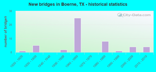
- New bridges - historical statistics
- 11920-1929
- 51930-1939
- 21950-1959
- 251960-1969
- 81980-1989
- 11990-1999
- 42000-2009
- 42010-2019
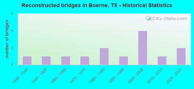
- Reconstructed bridges - Historical Statistics
- 11940-1949
- 11950-1959
- 11960-1969
- 11970-1979
- 21980-1989
- 11990-1999
- 42000-2009
- 12010-2019
- 22020-2022

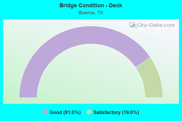
- Bridge Condition - Deck
- 81.0%Good
- 19.0%Satisfactory
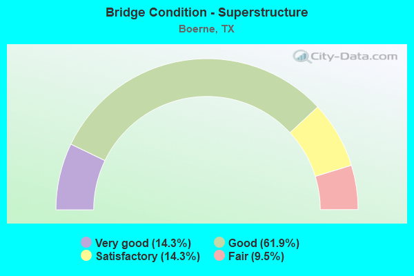
- Bridge Condition - Superstructure
- 14.3%Very good
- 61.9%Good
- 14.3%Satisfactory
- 9.5%Fair
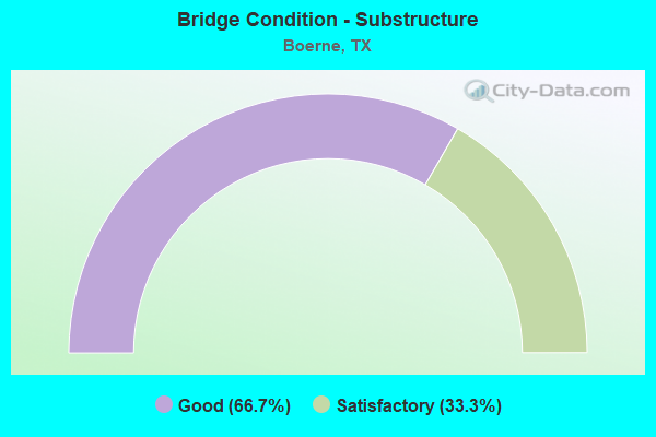
- Bridge Condition - Substructure
- 66.7%Good
- 33.3%Satisfactory
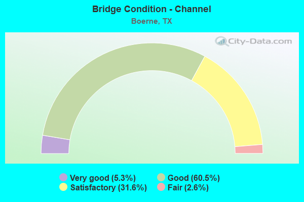
- Bridge Condition - Channel
- 5.3%Very good
- 60.5%Good
- 31.6%Satisfactory
- 2.6%Fair
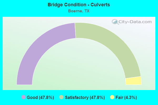
- Bridge Condition - Culverts
- 47.8%Good
- 47.8%Satisfactory
- 4.3%Fair
Find on map >> Show street view
Structure Number: 151310B00410002, Location: .1 MI S OF SAN ANTONIO ST (Lat: 29.789914, Lng: -98.737514), Route carried "on" structure: City street , Year Built: 1997, Status: Open, Structure Length: 1.19m (3.90ft), Average Daily Traffic: 5,028 (year 2020), Average Future Daily Traffic: 3,290 (year 2035), Features Intersected: FREDERICK CREEK, Facility Carried by Structure: SCHOOL STREET
Minimum Vertical Clearance: 30+ m (98+ ft), Kilometerpoint: 1.770, Lanes on structure: 2, Owner: City or Municipal Highway Agency, Approaching Roadway Width: 7.6m (24.9ft), Skew: 3 degrees, Material/Design: Prestressed concrete, Number Of Spans In Main Unit: 1, Length of Maximum Span: 11.9m (39.0ft), Curb or Sidewalk Widths: Left: 1.2m (3.9ft), Right: 0.0m, Curb-To-Curb Width: 9.4m (30.8ft), Out-to-Out Width: 11.1m (36.4ft)
Condition: Deck: Good, Superstructure: Very good, Substructure: Good, Channel: Good, Operating Rating: 32.7 metric tons, Method Used To Determine Operating Rating: Field evaluation and documented engineering judgment, Inventory Rating: 24.5 metric tons, Method Used To Determine Inventory Rating: Field evaluation and documented engineering judgment, Structural Evaluation: Equal to present minimum criteria, Deck Geometry: High priority of corrective action, Waterway Adequacy: Meets minimum limits, Approach Roadway Alignment: Equal to present desirable criteria, Designated Inspection Frequency: Every 24 months, Inspection Date: June 2021, Deck Structure Type: Concrete Cast-file-Place
Structure Number: 151310007205126, Location: 2.8 MI N OF SH 46, Route carried "under" structure: County highway , Year Built: 1966, Structure Length: 0. m, Average Daily Traffic: 1,780 (year 2012), Truck Traffic: 1%, Features Intersected: CIBOLO CRK & RANGER RD, Facility Carried by Structure: IH 10 WBML
Minimum Vertical Clearance: 4.95m (16.24ft), Kilometerpoint: 3.299, Lanes on structure: 2, Lanes under structure: 2, Material/Design: Prestressed concrete, Design/Construction: Stringer/Multi-beam, Length of Maximum Span: 16.8m (55.1ft)
Minimum Vertical Clearance: 4.95m (16.24ft), Kilometerpoint: 3.299, Lanes on structure: 2, Lanes under structure: 2, Material/Design: Prestressed concrete, Design/Construction: Stringer/Multi-beam, Length of Maximum Span: 16.8m (55.1ft)
Structure Number: 151310007205127, Location: 2.8 MI N OF SH 46, Route carried "under" structure: County highway , Year Built: 1966, Structure Length: 0. m, Average Daily Traffic: 1,780 (year 2012), Truck Traffic: 1%, Features Intersected: CIBOLO CRK & RANGER RD, Facility Carried by Structure: IH 10 EBML
Minimum Vertical Clearance: 4.80m (15.75ft), Kilometerpoint: 3.291, Lanes on structure: 2, Lanes under structure: 2, Material/Design: Prestressed concrete, Design/Construction: Stringer/Multi-beam, Length of Maximum Span: 16.8m (55.1ft)
Minimum Vertical Clearance: 4.80m (15.75ft), Kilometerpoint: 3.291, Lanes on structure: 2, Lanes under structure: 2, Material/Design: Prestressed concrete, Design/Construction: Stringer/Multi-beam, Length of Maximum Span: 16.8m (55.1ft)
Find on map >> Show street view
Structure Number: 151310007205168, Location: 6.1 MI SE OF FM 1621 (Lat: 29.870117, Lng: -98.793347), Route carried "under" structure: State highway 289, Year Built: 1969, Structure Length: 0. m, Average Daily Traffic: 2,960 (year 2012), Truck Traffic: 1%, Features Intersected: TURNAROUND, Facility Carried by Structure: IH 10 EBML
Minimum Vertical Clearance: 4.70m (15.42ft), Kilometerpoint: 11.895, Lanes on structure: 2, Lanes under structure: 2, Material/Design: Prestressed concrete, Design/Construction: Stringer/Multi-beam, Length of Maximum Span: 15.2m (49.9ft)
Find on map >> Show street view
Structure Number: 151310007206095, Location: 1.4 MI SE OF SH 16 (Lat: 29.767117, Lng: -98.719325), Route carried "under" structure: Interstate 10, Year Built: 1965, Structure Length: 0. m, Average Daily Traffic: 33,940 (year 2013), Truck Traffic: 10%, Features Intersected: IH 10, Facility Carried by Structure: BUS 87
Minimum Vertical Clearance: 5.56m (18.24ft), Kilometerpoint: 34.250, Lanes on structure: 2, Lanes under structure: 4, Material/Design: Steel continuous, Design/Construction: Stringer/Multi-beam, Length of Maximum Span: 25.9m (85.0ft)
Find on map >> Show street view
Structure Number: 151310007206131, Location: 1.7 MI SE OF US 87 BUS (Lat: 29.795225, Lng: -98.752339), Route carried "under" structure: Interstate 10, Year Built: 1966, Structure Length: 0. m, Average Daily Traffic: 23,780 (year 2013), Truck Traffic: 10%, Features Intersected: IH 10, Facility Carried by Structure: JOHNS RD
Minimum Vertical Clearance: 5.01m (16.44ft), Kilometerpoint: 29.717, Lanes on structure: 2, Lanes under structure: 4, Material/Design: Steel continuous, Design/Construction: Stringer/Multi-beam, Length of Maximum Span: 24.4m (80.1ft)
Find on map >> Show street view
Structure Number: 151310007206406, Location: 1.3 MI SE of US 87 (Lat: 29.754153, Lng: -98.704742), Route carried "under" structure: City street , Year Built: 2017, Structure Length: 0. m, Average Daily Traffic: 2,000 (year 2019), Truck Traffic: 12%, Features Intersected: Scenic Loop Road, Facility Carried by Structure: IH 10
Minimum Vertical Clearance: 6.68m (21.92ft), Kilometerpoint: 0.362, Lanes on structure: 4, Lanes under structure: 7, Material/Design: Prestressed concrete, Design/Construction: Stringer/Multi-beam, Length of Maximum Span: 30.5m (100.1ft)