Bridge Statistics for Boone, North Carolina (NC)
Condition, Traffic, Stress, Structural Evaluation, Project Costs
- National Bridge Inventory (NBI) Statistics
- 59Number of bridges
- 361ft / 110mTotal length
- $720,000Total costs
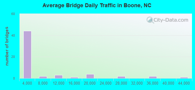
- 326,275Total average daily traffic
- 35,422Total average daily truck traffic
- 661,730Total future (year 2025) average daily traffic
- National Bridge Inventory (NBI) Registered Bridges for Boone
- No street view available for this location
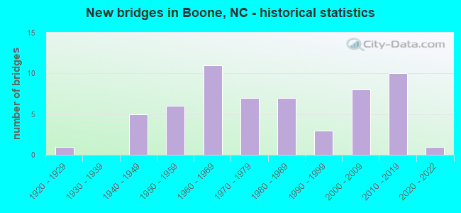
- New bridges - historical statistics
- 11920-1929
- 51940-1949
- 61950-1959
- 111960-1969
- 71970-1979
- 71980-1989
- 31990-1999
- 82000-2009
- 102010-2019
- 12020-2022
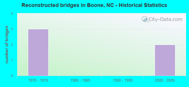
- Reconstructed bridges - Historical Statistics
- 31970-1979
- 01980-1989
- 01990-1999
- 22000-2009
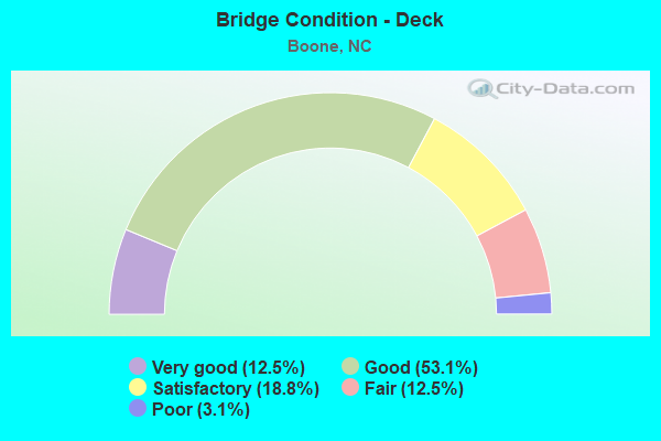
- Bridge Condition - Deck
- 12.5%Very good
- 53.1%Good
- 18.8%Satisfactory
- 12.5%Fair
- 3.1%Poor
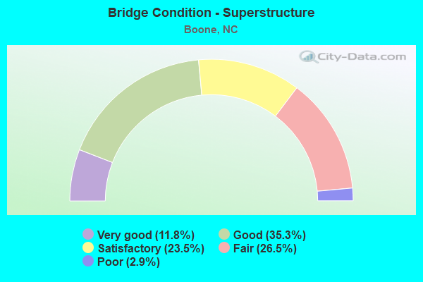
- Bridge Condition - Superstructure
- 11.8%Very good
- 35.3%Good
- 23.5%Satisfactory
- 26.5%Fair
- 2.9%Poor
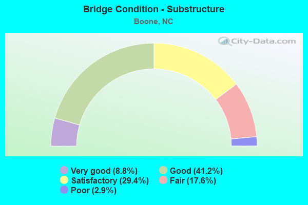
- Bridge Condition - Substructure
- 8.8%Very good
- 41.2%Good
- 29.4%Satisfactory
- 17.6%Fair
- 2.9%Poor
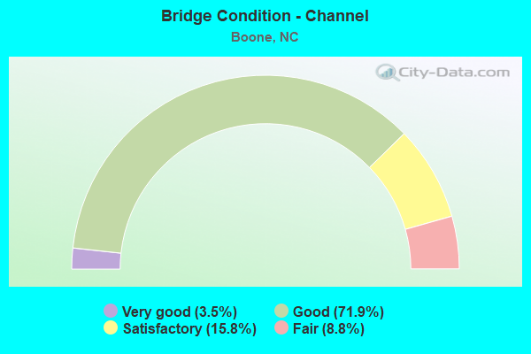
- Bridge Condition - Channel
- 3.5%Very good
- 71.9%Good
- 15.8%Satisfactory
- 8.8%Fair
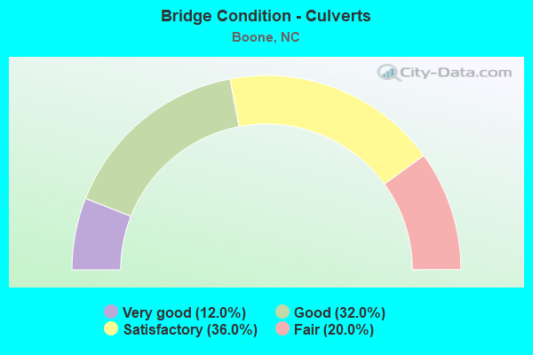
- Bridge Condition - Culverts
- 12.0%Very good
- 32.0%Good
- 36.0%Satisfactory
- 20.0%Fair
Find on map >> Show street view
Structure Number: 1890278, Location: 0.01MI.W.JCT. US221 (Lat: 36.169556, Lng: -81.646500), Route carried "on" structure: State highway 1540, Year Built: 2021, Status: Open, Structure Length: 1.31m (4.30ft), Average Daily Traffic: 680 (year 2017), Truck Traffic: 6%, Average Future Daily Traffic: 1,360 (year 2040), Design Load: HL 93, Features Intersected: MIDDLE FORK SOUTH FORK N
Minimum Vertical Clearance: 30+ m (98+ ft), Kilometerpoint: 0.000, Lanes on structure: 3, Owner: State Highway Agency, Approaching Roadway Width: 14.0m (45.9ft), Material/Design: Concrete continuous, Design/Construction: Culvert, Number Of Spans In Main Unit: 3, Length of Maximum Span: 4.2m (13.8ft)
Condition: Channel: Very good, Culverts: Good, Operating Rating: 72.5 metric tons, Method Used To Determine Operating Rating: Load and Resistance Factor (LRFR), Inventory Rating: 56.2 metric tons, Method Used To Determine Inventory Rating: Load and Resistance Factor (LRFR), Structural Evaluation: Better than present minimum criteria, Waterway Adequacy: Better than present minimum criteria, Approach Roadway Alignment: Equal to present desirable criteria, Designated Inspection Frequency: Every 24 months, Inspection Date: August 2021
Find on map >> Show street view
Structure Number: 1890317, Location: 1.5 MI.S.JCT.SR1392 (Lat: 36.245981, Lng: -81.594625), Route carried "on" structure: State highway 1355, Year Built: 2002, Status: Open, Structure Length: 5.48m (17.98ft), Average Daily Traffic: 770 (year 2017), Truck Traffic: 6%, Average Future Daily Traffic: 1,540 (year 2040), Design Load: HS 20+Mod, Features Intersected: SOUTH FORK NEW RIVER
Minimum Vertical Clearance: 30+ m (98+ ft), Kilometerpoint: 0.000, Lanes on structure: 2, Owner: State Highway Agency, Approaching Roadway Width: 6.0m (19.7ft), Skew: 2 degrees, Material/Design: Prestressed concrete, Design/Construction: Slab, Number Of Spans In Main Unit: 3, Length of Maximum Span: 17.9m (58.7ft), Curb-To-Curb Width: 7.2m (23.6ft), Out-to-Out Width: 8.2m (26.9ft)
Condition: Deck: Good, Superstructure: Good, Substructure: Good, Channel: Good, Operating Rating: 70.7 metric tons, Method Used To Determine Operating Rating: Load Factor (LF), Inventory Rating: 41.7 metric tons, Method Used To Determine Inventory Rating: Load Factor (LF), Structural Evaluation: Better than present minimum criteria, Deck Geometry: Meets minimum limits, Waterway Adequacy: Better than present minimum criteria, Approach Roadway Alignment: Equal to present minimum criteria, Designated Inspection Frequency: Every 24 months, Inspection Date: October 2021, Deck Structure Type: Concrete Cast-file-Place, Wearing Surface/Protective System: Wearing Surface: Bituminous, Deck Protection: Epoxy Coated Reinforcing
Find on map >> Show street view
Structure Number: 1890324, Location: 50 FT.S.JCT.SR1543 (Lat: 36.191428, Lng: -81.655233), Route carried "on" structure: State highway 1542, Year Built: 2005, Status: Open, Structure Length: 2.71m (8.89ft), Average Daily Traffic: 330 (year 2017), Truck Traffic: 6%, Average Future Daily Traffic: 660 (year 2040), Design Load: HS 20+Mod, Features Intersected: MID.FORK S.FORK NEW RVR.
Minimum Vertical Clearance: 30+ m (98+ ft), Kilometerpoint: 0.000, Lanes on structure: 2, Owner: State Highway Agency, Approaching Roadway Width: 4.5m (14.8ft), Skew: 2 degrees, Material/Design: Prestressed concrete, Design/Construction: Stringer/Multi-beam, Number Of Spans In Main Unit: 1, Length of Maximum Span: 25.6m (84.0ft), Curb-To-Curb Width: 6.5m (21.3ft), Out-to-Out Width: 7.3m (24.0ft)
Condition: Deck: Very good, Superstructure: Very good, Substructure: Good, Channel: Good, Operating Rating: 81.6 metric tons, Method Used To Determine Operating Rating: Load Factor (LF), Inventory Rating: 37.1 metric tons, Method Used To Determine Inventory Rating: Load Factor (LF), Structural Evaluation: Better than present minimum criteria, Deck Geometry: Meets minimum limits, Waterway Adequacy: Better than present minimum criteria, Approach Roadway Alignment: Equal to present minimum criteria, Designated Inspection Frequency: Every 24 months, Inspection Date: August 2021, Deck Structure Type: Concrete Cast-file-Place, Wearing Surface/Protective System: Wearing Surface: Monolithic Concrete
Find on map >> Show street view
Structure Number: 1890334, Location: 50 FT..W.JCT.SR1100 (Lat: 36.278047, Lng: -81.570589), Route carried "on" structure: State highway 1351, Year Built: 2011, Status: Open, Structure Length: 7.92m (25.98ft), Average Daily Traffic: 120 (year 2000), Truck Traffic: 6%, Average Future Daily Traffic: 240 (year 2040), Design Load: HL 93, Features Intersected: S.F.NEW RVR & NON-SYSTEM
Minimum Vertical Clearance: 30+ m (98+ ft), Kilometerpoint: 0.000, Lanes on structure: 2, Lanes under structure: 2, Owner: State Highway Agency, Approaching Roadway Width: 8.5m (27.9ft), Material/Design: Prestressed concrete, Design/Construction: Slab, Number Of Spans In Main Unit: 5, Length of Maximum Span: 17.9m (58.7ft), Curb-To-Curb Width: 8.8m (28.9ft), Out-to-Out Width: 10.0m (32.8ft)
Condition: Deck: Good, Superstructure: Good, Substructure: Good, Channel: Good, Operating Rating: 54.4 metric tons, Method Used To Determine Operating Rating: Load and Resistance Factor (LRFR), Inventory Rating: 40.8 metric tons, Method Used To Determine Inventory Rating: Load and Resistance Factor (LRFR), Structural Evaluation: Better than present minimum criteria, Deck Geometry: Equal to present minimum criteria, Underclear: High priority of corrective action, Waterway Adequacy: Better than present minimum criteria, Approach Roadway Alignment: Equal to present desirable criteria, Designated Inspection Frequency: Every 24 months, Underwater Inspection Frequency: Every 60 months, Inspection Date: June 2020, Underwater Inspection Date: July 2021, Deck Structure Type: Concrete Precast Panels, Wearing Surface/Protective System: Wearing Surface: Bituminous
Find on map >> Show street view
Structure Number: 1890335, Location: 0.1MI.S.JCT.NC105 (Lat: 36.202683, Lng: -81.671992), Route carried "on" structure: City street , Year Built: 1977, Status: Open, Structure Length: 0.64m (2.10ft), Average Daily Traffic: 100 (year 1992), Average Future Daily Traffic: 200 (year 2040), Design Load: HS 20+Mod, Features Intersected: HODGES CREEK, Facility Carried by Structure: WILSON DR.
Minimum Vertical Clearance: 30+ m (98+ ft), Kilometerpoint: 0.000, Lanes on structure: 3, Owner: City or Municipal Highway Agency, Approaching Roadway Width: 12.4m (40.7ft), Skew: 4 degrees, Material/Design: Steel, Design/Construction: Culvert, Number Of Spans In Main Unit: 2, Length of Maximum Span: 2.1m (6.9ft)
Condition: Channel: Good, Culverts: Satisfactory, Operating Rating: 89.8 metric tons, Method Used To Determine Operating Rating: Load Factor (LF), Inventory Rating: 62.5 metric tons, Method Used To Determine Inventory Rating: Load Factor (LF), Structural Evaluation: Equal to present minimum criteria, Waterway Adequacy: Better than present minimum criteria, Approach Roadway Alignment: Equal to present desirable criteria, Designated Inspection Frequency: Every 24 months, Inspection Date: June 2020
Find on map >> Show street view
Structure Number: 1890337, Location: .3 MI.S.JCT.SR1107 (Lat: 36.206694, Lng: -81.710789), Route carried "on" structure: State highway 105, Year Built: 1956, Status: Open, Structure Length: 0.67m (2.20ft), Average Daily Traffic: 19,000 (year 2019), Truck Traffic: 14%, Average Future Daily Traffic: 38,000 (year 2040), Design Load: HS 20+Mod, Features Intersected: LAUREL FORK CREEK
Minimum Vertical Clearance: 30+ m (98+ ft), Kilometerpoint: 0.000, Lanes on structure: 2, Base Highway Network: Yes (Inventory Route: 3, Subroute: 5), Owner: State Highway Agency, Approaching Roadway Width: 12.4m (40.7ft), Material/Design: Concrete continuous, Design/Construction: Culvert, Number Of Spans In Main Unit: 3, Length of Maximum Span: 2.1m (6.9ft)
Condition: Channel: Good, Culverts: Satisfactory, Operating Rating: 89.8 metric tons, Method Used To Determine Operating Rating: Load and Resistance Factor (LRFR), Inventory Rating: 79.8 metric tons, Method Used To Determine Inventory Rating: Load and Resistance Factor (LRFR), Structural Evaluation: Equal to present minimum criteria, Waterway Adequacy: Better than present minimum criteria, Approach Roadway Alignment: Equal to present desirable criteria, Designated Inspection Frequency: Every 24 months, Inspection Date: September 2021
Find on map >> Show street view
Structure Number: 1890339, Location: 0.05 MI.S.JCT.US321 (Lat: 36.201331, Lng: -81.664583), Route carried "on" structure: City street , Year Built: 1922, Status: Posted for load, Structure Length: 1.21m (3.97ft), Average Daily Traffic: 300 (year 1996), Truck Traffic: 7%, Average Future Daily Traffic: 600 (year 2040), Design Load: H 15, Features Intersected: WINKLER CREEK, Facility Carried by Structure: MEADOWVIEW DRIVE
Minimum Vertical Clearance: 30+ m (98+ ft), Kilometerpoint: 0.000, Lanes on structure: 2, Owner: City or Municipal Highway Agency, Approaching Roadway Width: 6.0m (19.7ft), Skew: 3 degrees, Material/Design: Concrete, Design/Construction: Tee Beam, Number Of Spans In Main Unit: 1, Length of Maximum Span: 11.5m (37.7ft), Curb or Sidewalk Widths: Left: 0.1m (0.3ft), Right: 0.1m (0.3ft), Curb-To-Curb Width: 6.1m (20.0ft), Out-to-Out Width: 7.1m (23.3ft)
Condition: Deck: Fair, Superstructure: Fair, Substructure: Fair, Channel: Good, Operating Rating: 24.4 metric tons, Method Used To Determine Operating Rating: Field evaluation and documented engineering judgment, Inventory Rating: 19.0 metric tons, Method Used To Determine Inventory Rating: Field evaluation and documented engineering judgment, Structural Evaluation: Somewhat better than minimum adequacy, Deck Geometry: Meets minimum limits, Waterway Adequacy: Better than present minimum criteria, Approach Roadway Alignment: Equal to present desirable criteria, Bridge Posting: Required (Relationship of Operating Rating to Maximum Legal Load: 0.1 - 9.9% below), Designated Inspection Frequency: Every 24 months, Inspection Date: June 2020, Deck Structure Type: Concrete Cast-file-Place, Wearing Surface/Protective System: Wearing Surface: Bituminous
Find on map >> Show street view
Structure Number: 189034, Location: 0.01 MI. S. JCT.US321 (Lat: 36.202489, Lng: -81.664364), Route carried "on" structure: City street , Year Built: 1970, Status: Open, Structure Length: 1.00m (3.28ft), Average Daily Traffic: 750 (year 1996), Truck Traffic: 7%, Average Future Daily Traffic: 1,500 (year 2040), Design Load: HS 20+Mod, Features Intersected: BOONE CREEK, Facility Carried by Structure: MEADOWVIEW DRIVE
Minimum Vertical Clearance: 30+ m (98+ ft), Kilometerpoint: 0.000, Lanes on structure: 3, Owner: City or Municipal Highway Agency, Approaching Roadway Width: 9.1m (29.9ft), Skew: 2 degrees, Material/Design: Concrete continuous, Design/Construction: Culvert, Number Of Spans In Main Unit: 3, Length of Maximum Span: 3.0m (9.8ft)
Condition: Channel: Fair, Culverts: Fair, Operating Rating: 41.7 metric tons, Method Used To Determine Operating Rating: Field evaluation and documented engineering judgment, Inventory Rating: 32.6 metric tons, Method Used To Determine Inventory Rating: Field evaluation and documented engineering judgment, Structural Evaluation: Somewhat better than minimum adequacy, Waterway Adequacy: Better than present minimum criteria, Approach Roadway Alignment: Equal to present desirable criteria, Designated Inspection Frequency: Every 24 months, Inspection Date: June 2020
Find on map >> Show street view
Structure Number: 1890346, Location: 0.2 MI.N.JCT.STATE FARM R (Lat: 36.205139, Lng: -81.650208), Route carried "on" structure: City street , Year Built: 1970, Status: Posted for load, Structure Length: 1.82m (5.97ft), Average Daily Traffic: 100 (year 1992), Average Future Daily Traffic: 200 (year 2040), Design Load: HS 20+Mod, Features Intersected: SOUTH FORK NEW RIVER, Facility Carried by Structure: HUNTING HILLS LANE
Minimum Vertical Clearance: 30+ m (98+ ft), Kilometerpoint: 0.000, Lanes on structure: 2, Owner: City or Municipal Highway Agency, Approaching Roadway Width: 8.5m (27.9ft), Material/Design: Prestressed concrete, Design/Construction: Channel Beam, Number Of Spans In Main Unit: 6, Length of Maximum Span: 6.7m (22.0ft), Curb or Sidewalk Widths: Left: 1.2m (3.9ft), Right: 0.0m, Curb-To-Curb Width: 6.1m (20.0ft), Out-to-Out Width: 7.4m (24.3ft)
Condition: Deck: Fair, Superstructure: Fair, Substructure: Satisfactory, Channel: Good, Operating Rating: 33.5 metric tons, Method Used To Determine Operating Rating: Field evaluation and documented engineering judgment, Inventory Rating: 19.9 metric tons, Method Used To Determine Inventory Rating: Field evaluation and documented engineering judgment, Structural Evaluation: Somewhat better than minimum adequacy, Deck Geometry: Somewhat better than minimum adequacy, Waterway Adequacy: Better than present minimum criteria, Approach Roadway Alignment: Equal to present desirable criteria, Bridge Posting: Required (Relationship of Operating Rating to Maximum Legal Load: 30.0 - 39.9% below), Designated Inspection Frequency: Every 24 months, Inspection Date: June 2020, Deck Structure Type: Concrete Cast-file-Place, Wearing Surface/Protective System: Wearing Surface: Bituminous
Find on map >> Show street view
Structure Number: 5140093P, Location: 9.2 MILES FROM U.S. ROUTE (Lat: 36.191933, Lng: -81.603100), Route carried "on" structure: Federal lands road 1, Year Built: 1941, Status: Open, Structure Length: 0.79m (2.59ft), Average Daily Traffic: 2,300 (year 2013), Truck Traffic: 1%, Average Future Daily Traffic: 2,530 (year 2033), Design Load: H 15, Features Intersected: BAMBOO ROAD, Facility Carried by Structure: BLUE RIDGE PARKWAY
Minimum Vertical Clearance: 30+ m (98+ ft), Kilometerpoint: 459.436, Lanes on structure: 2, Lanes under structure: 2, Owner: National Park Service, Approaching Roadway Width: 9.1m (29.9ft), Material/Design: Concrete, Design/Construction: Frame, Number Of Spans In Main Unit: 1, Length of Maximum Span: 7.9m (25.9ft), Curb-To-Curb Width: 9.2m (30.2ft), Out-to-Out Width: 10.4m (34.1ft)
Condition: Superstructure: Satisfactory, Substructure: Good, Operating Rating: 34.7 metric tons, Method Used To Determine Operating Rating: Load Factor (LF), Inventory Rating: 20.9 metric tons, Method Used To Determine Inventory Rating: Load Factor (LF), Structural Evaluation: Somewhat better than minimum adequacy, Deck Geometry: Meets minimum limits, Underclear: High priority of corrective action, Approach Roadway Alignment: Equal to present desirable criteria, Designated Inspection Frequency: Every 24 months, Inspection Date: June 2021, Bridge Improvement Cost: $70,000, Roadway Improvement Cost: $7,000, Total Project Cost: $105,000 ( Estimate for 2017), Wearing Surface/Protective System: Wearing Surface: Bituminous
Find on map >> Show street view
Structure Number: 5140094P, Location: 10 MILES FROM U.S. ROUTE (Lat: 36.183528, Lng: -81.609806), Route carried "on" structure: Federal lands road 1, Year Built: 1949, Year Reconstructed: 2009, Status: Open, Structure Length: 10.67m (35.01ft), Average Daily Traffic: 2,300 (year 2013), Truck Traffic: 1%, Average Future Daily Traffic: 2,530 (year 2033), Design Load: H 15, Features Intersected: GOSHEN CREEK & NC ROUTE, Facility Carried by Structure: BLUE RIDGE PARKWAY
Minimum Vertical Clearance: 30+ m (98+ ft), Kilometerpoint: 460.707, Lanes on structure: 2, Lanes under structure: 2, Owner: National Park Service, Approaching Roadway Width: 10.4m (34.1ft), Material/Design: Steel, Design/Construction: Girder and Floorbeam System, Number Of Spans In Main Unit: 4, Length of Maximum Span: 26.7m (87.6ft), Curb or Sidewalk Widths: Left: 1.1m (3.6ft), Right: 0.0m, Curb-To-Curb Width: 8.0m (26.2ft), Out-to-Out Width: 10.1m (33.1ft)
Condition: Deck: Good, Superstructure: Satisfactory, Substructure: Good, Channel: Good, Operating Rating: 31.6 metric tons, Method Used To Determine Operating Rating: Load Factor (LF), Inventory Rating: 19.0 metric tons, Method Used To Determine Inventory Rating: Load Factor (LF), Structural Evaluation: Somewhat better than minimum adequacy, Deck Geometry: High priority of corrective action, Waterway Adequacy: Superior to present desirable criteria, Approach Roadway Alignment: Equal to present desirable criteria, Designated Inspection Frequency: Every 24 months, Critical Feature Inspection Frequency: Every 24 months, Inspection Date: June 2021, Critical Feature Inspection Date: June 2021, Bridge Improvement Cost: $140,000, Roadway Improvement Cost: $14,000, Total Project Cost: $210,000 ( Estimate for 2015), Deck Structure Type: Concrete Cast-file-Place
Find on map >> Show street view
Structure Number: 5140167P, Location: 5.7 MILES FROM U.S. ROUTE (Lat: 36.224472, Lng: -81.576111), Route carried "on" structure: Federal lands road 1, Year Built: 1958, Status: Open, Structure Length: 0.75m (2.46ft), Average Daily Traffic: 2,300 (year 2007), Truck Traffic: 1%, Average Future Daily Traffic: 2,530 (year 2027), Features Intersected: NC ROUTE 1508, Facility Carried by Structure: BLUE RIDGE PARKWAY
Minimum Vertical Clearance: 30+ m (98+ ft), Kilometerpoint: 453.890, Lanes on structure: 2, Lanes under structure: 2, Owner: National Park Service, Approaching Roadway Width: 10.4m (34.1ft), Material/Design: Concrete, Design/Construction: Frame, Number Of Spans In Main Unit: 1, Length of Maximum Span: 7.5m (24.6ft), Curb-To-Curb Width: 9.1m (29.9ft), Out-to-Out Width: 10.4m (34.1ft)
Condition: Superstructure: Good, Substructure: Good, Structural Evaluation: Better than present minimum criteria, Deck Geometry: Meets minimum limits, Underclear: High priority of corrective action, Approach Roadway Alignment: Equal to present desirable criteria, Designated Inspection Frequency: Every 48 months, Inspection Date: June 2019, Bridge Improvement Cost: $46,000, Roadway Improvement Cost: $5,000, Total Project Cost: $69,000 ( Estimate for 2019), Wearing Surface/Protective System: Wearing Surface: Bituminous
Find on map >> Show street view
Structure Number: 5140168P, Location: 5.2 MILES FROM U.S. ROUTE (Lat: 36.177444, Lng: -81.611056), Route carried "on" structure: Federal lands road 1, Year Built: 1950, Status: Open, Structure Length: 0.78m (2.56ft), Average Daily Traffic: 2,300 (year 2013), Truck Traffic: 1%, Average Future Daily Traffic: 2,530 (year 2033), Design Load: H 15, Features Intersected: GOSHEN CREEK, Facility Carried by Structure: BLUE RIDGE PARKWAY
Minimum Vertical Clearance: 30+ m (98+ ft), Kilometerpoint: 461.383, Lanes on structure: 2, Owner: National Park Service, Approaching Roadway Width: 9.8m (32.2ft), Skew: 3 degrees, Material/Design: Concrete, Design/Construction: Culvert, Number Of Spans In Main Unit: 2, Length of Maximum Span: 3.4m (11.2ft)
Condition: Channel: Satisfactory, Culverts: Satisfactory, Operating Rating: 40.9 metric tons, Method Used To Determine Operating Rating: Field evaluation and documented engineering judgment, Inventory Rating: 24.5 metric tons, Method Used To Determine Inventory Rating: Field evaluation and documented engineering judgment, Structural Evaluation: Equal to present minimum criteria, Waterway Adequacy: Superior to present desirable criteria, Approach Roadway Alignment: Equal to present desirable criteria, Designated Inspection Frequency: Every 24 months, Inspection Date: June 2021, Bridge Improvement Cost: $80,000, Roadway Improvement Cost: $8,000, Total Project Cost: $120,000 ( Estimate for 2017)
Find on map >> Show street view
Structure Number: 5140169P, Location: 5.1 MILES FROM U.S. ROUTE (Lat: 36.176056, Lng: -81.610722), Route carried "on" structure: Federal lands road 1, Year Built: 1950, Status: Open, Structure Length: 0.75m (2.46ft), Average Daily Traffic: 2,300 (year 2013), Truck Traffic: 1%, Average Future Daily Traffic: 2,530 (year 2033), Features Intersected: GOSHEN CREEK, Facility Carried by Structure: BLUE RIDGE PARKWAY
Minimum Vertical Clearance: 30+ m (98+ ft), Kilometerpoint: 461.580, Lanes on structure: 2, Owner: National Park Service, Approaching Roadway Width: 10.4m (34.1ft), Skew: 3 degrees, Material/Design: Concrete, Design/Construction: Culvert, Number Of Spans In Main Unit: 2, Length of Maximum Span: 3.4m (11.2ft)
Condition: Channel: Satisfactory, Culverts: Satisfactory, Operating Rating: 40.9 metric tons, Method Used To Determine Operating Rating: Field evaluation and documented engineering judgment, Inventory Rating: 24.5 metric tons, Method Used To Determine Inventory Rating: Field evaluation and documented engineering judgment, Structural Evaluation: Equal to present minimum criteria, Waterway Adequacy: Superior to present desirable criteria, Approach Roadway Alignment: Equal to present desirable criteria, Designated Inspection Frequency: Every 48 months, Inspection Date: June 2019, Bridge Improvement Cost: $44,000, Roadway Improvement Cost: $4,000, Total Project Cost: $66,000 ( Estimate for 2019)
Find on map >> Show street view
Structure Number: 5140170P, Location: 5.0 MILES FROM U.S. ROUTE (Lat: 36.174389, Lng: -81.611361), Route carried "on" structure: Federal lands road 1, Year Built: 1950, Status: Open, Structure Length: 1.10m (3.61ft), Average Daily Traffic: 2,300 (year 2013), Truck Traffic: 1%, Average Future Daily Traffic: 2,530 (year 2033), Design Load: H 15, Features Intersected: GOSHEN CREEK, Facility Carried by Structure: BLUE RIDGE PARKWAY
Minimum Vertical Clearance: 30+ m (98+ ft), Kilometerpoint: 461.721, Lanes on structure: 2, Owner: National Park Service, Approaching Roadway Width: 12.2m (40.0ft), Skew: 5 degrees, Material/Design: Concrete, Design/Construction: Culvert, Number Of Spans In Main Unit: 2, Length of Maximum Span: 4.9m (16.1ft), Curb-To-Curb Width: 6.7m (22.0ft)
Condition: Channel: Fair, Culverts: Fair, Operating Rating: 40.9 metric tons, Method Used To Determine Operating Rating: Allowable Stress (AS), Inventory Rating: 24.5 metric tons, Method Used To Determine Inventory Rating: Allowable Stress (AS), Structural Evaluation: Somewhat better than minimum adequacy, Deck Geometry: High priority of replacement, Waterway Adequacy: Superior to present desirable criteria, Approach Roadway Alignment: Equal to present desirable criteria, Designated Inspection Frequency: Every 24 months, Inspection Date: June 2021, Bridge Improvement Cost: $100,000, Roadway Improvement Cost: $10,000, Total Project Cost: $150,000 ( Estimate for 2017)