Bridge Statistics for Bordentown, New Jersey (NJ)
Condition, Traffic, Stress, Structural Evaluation, Project Costs
- National Bridge Inventory (NBI) Statistics
- 62Number of bridges
- 1,257ft / 383mTotal length
- $9,310,000Total costs
- 2,246,034Total average daily traffic
- 213,516Total average daily truck traffic
- National Bridge Inventory (NBI) Registered Bridges for Bordentown
- No street view available for this location
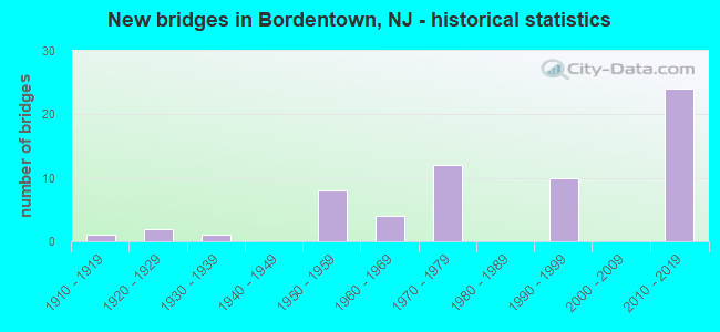
- New bridges - historical statistics
- 11910-1919
- 21920-1929
- 11930-1939
- 81950-1959
- 41960-1969
- 121970-1979
- 101990-1999
- 242010-2019

- Reconstructed bridges - Historical Statistics
- 11970-1979
- 21980-1989
- 01990-1999
- 12000-2009


- Bridge Condition - Deck
- 6.1%Very good
- 75.8%Good
- 6.1%Satisfactory
- 6.1%Fair
- 6.1%Poor

- Bridge Condition - Superstructure
- 20.0%Very good
- 34.3%Good
- 28.6%Satisfactory
- 11.4%Fair
- 5.7%Poor

- Bridge Condition - Substructure
- 22.9%Very good
- 37.1%Good
- 22.9%Satisfactory
- 14.3%Fair
- 2.9%Poor

- Bridge Condition - Channel
- 15.4%Excellent
- 15.4%Very good
- 30.8%Good
- 23.1%Satisfactory
- 15.4%Fair
Find on map >> Show street view
Structure Number: 31716, Location: 0.28 MI NORTH OF I295 JCT (Lat: 40.137119, Lng: -74.711189), Route carried "on" structure: US 130, Year Built: 1974, Status: Open, Structure Length: 2.29m (7.51ft), Average Daily Traffic: 29,672 (year 2020), Truck Traffic: 4%, Average Future Daily Traffic: 36,199 (year 2040), Features Intersected: BLACK'S CREEK
Minimum Vertical Clearance: 30+ m (98+ ft), Kilometerpoint: 88.755, Lanes on structure: 6, Base Highway Network: Yes, Owner: State Highway Agency, Approaching Roadway Width: 37.2m (122.0ft), Skew: 30 degrees, Material/Design: Steel, Design/Construction: Culvert, Number Of Spans In Main Unit: 3, Length of Maximum Span: 6.1m (20.0ft)
Condition: Channel: Satisfactory, Culverts: Satisfactory, Structural Evaluation: Equal to present minimum criteria, Waterway Adequacy: Equal to present desirable criteria, Approach Roadway Alignment: Equal to present desirable criteria, Designated Inspection Frequency: Every 24 months, Inspection Date: June 2020
Find on map >> Show street view
Structure Number: 325151, Location: JCT OF US130 & US206 (Lat: 40.141881, Lng: -74.703139), Route carried "on" structure: US 206, Year Built: 1962, Status: Open, Structure Length: 4.27m (14.01ft), Average Daily Traffic: 11,115 (year 2021), Truck Traffic: 4%, Average Future Daily Traffic: 13,339 (year 2041), Design Load: H 20, Features Intersected: US-130 NB
Minimum Vertical Clearance: 30+ m (98+ ft), Kilometerpoint: 57.309, Lanes on structure: 2, Lanes under structure: 2, Base Highway Network: Yes, Owner: State Highway Agency, Approaching Roadway Width: 11.3m (37.1ft), Skew: 6 degrees, Material/Design: Steel, Design/Construction: Stringer/Multi-beam, Number Of Spans In Main Unit: 1, Length of Maximum Span: 41.8m (137.1ft), Curb or Sidewalk Widths: Left: 0.5m (1.6ft), Right: 0.8m (2.6ft), Curb-To-Curb Width: 11.3m (37.1ft), Out-to-Out Width: 13.6m (44.6ft)
Condition: Deck: Poor, Superstructure: Satisfactory, Substructure: Satisfactory, Inventory Rating: 61.7 metric tons, Method Used To Determine Inventory Rating: Load Factor (LF), Structural Evaluation: Equal to present minimum criteria, Deck Geometry: Equal to present minimum criteria, Underclear: Equal to present minimum criteria, Approach Roadway Alignment: Equal to present minimum criteria, Designated Inspection Frequency: Every 24 months, Inspection Date: March 2021, Deck Structure Type: Concrete Cast-file-Place, Wearing Surface/Protective System: Wearing Surface: Monolithic Concrete
Find on map >> Show street view
Structure Number: 32615, Location: 0.39 MI S OF CR 662 (Lat: 40.152819, Lng: -74.699131), Route carried "on" structure: US 206, Year Built: 1961, Status: Open, Structure Length: 4.45m (14.60ft), Average Daily Traffic: 10,254 (year 2021), Truck Traffic: 4%, Average Future Daily Traffic: 12,512 (year 2041), Design Load: HS 20+Mod, Features Intersected: US-130 SB
Minimum Vertical Clearance: 30+ m (98+ ft), Kilometerpoint: 58.516, Lanes on structure: 2, Lanes under structure: 2, Base Highway Network: Yes, Owner: State Highway Agency, Approaching Roadway Width: 12.1m (39.7ft), Skew: 4 degrees, Material/Design: Steel, Design/Construction: Stringer/Multi-beam, Number Of Spans In Main Unit: 3, Length of Maximum Span: 20.1m (65.9ft), Curb or Sidewalk Widths: Left: 0.5m (1.6ft), Right: 1.4m (4.6ft), Curb-To-Curb Width: 12.1m (39.7ft), Out-to-Out Width: 14.8m (48.6ft)
Condition: Deck: Poor, Superstructure: Satisfactory, Substructure: Satisfactory, Operating Rating: 67.1 metric tons, Method Used To Determine Operating Rating: Load Factor (LF), Inventory Rating: 39.9 metric tons, Method Used To Determine Inventory Rating: Load Factor (LF), Structural Evaluation: Equal to present minimum criteria, Deck Geometry: Better than present minimum criteria, Underclear: Equal to present minimum criteria, Approach Roadway Alignment: Equal to present minimum criteria, Designated Inspection Frequency: Every 24 months, Inspection Date: March 2021, Deck Structure Type: Concrete Cast-file-Place, Wearing Surface/Protective System: Wearing Surface: Monolithic Concrete
Find on map >> Show street view
Structure Number: 328168, Location: 0.32 MI S OF US 130 JCT (Lat: 40.130950, Lng: -74.715819), Route carried "on" structure: City street , Year Built: 1973, Status: Open, Structure Length: 6.68m (21.92ft), Average Daily Traffic: 9,837 (year 2020), Truck Traffic: 3%, Average Future Daily Traffic: 12,004 (year 2040), Design Load: HS 20, Features Intersected: I-295, Facility Carried by Structure: DUNNS MILL ROAD
Minimum Vertical Clearance: 30+ m (98+ ft), Kilometerpoint: 1.336, Lanes on structure: 2, Lanes under structure: 6, Owner: State Highway Agency, Approaching Roadway Width: 9.1m (29.9ft), Skew: 1 degrees, Material/Design: Steel, Design/Construction: Stringer/Multi-beam, Number Of Spans In Main Unit: 2, Length of Maximum Span: 32.6m (107.0ft), Curb or Sidewalk Widths: Left: 1.8m (5.9ft), Right: 1.8m (5.9ft), Curb-To-Curb Width: 9.1m (29.9ft), Out-to-Out Width: 13.4m (44.0ft)
Condition: Deck: Satisfactory, Superstructure: Good, Substructure: Good, Operating Rating: 84.4 metric tons, Method Used To Determine Operating Rating: Load Factor (LF), Inventory Rating: 49.9 metric tons, Method Used To Determine Inventory Rating: Load Factor (LF), Structural Evaluation: Better than present minimum criteria, Deck Geometry: Meets minimum limits, Underclear: Somewhat better than minimum adequacy, Approach Roadway Alignment: Better than present minimum criteria, Designated Inspection Frequency: Every 24 months, Inspection Date: April 2020, Deck Structure Type: Concrete Cast-file-Place, Wearing Surface/Protective System: Wearing Surface: Monolithic Concrete
Find on map >> Show street view
Structure Number: 328169, Location: AT I-295 EXIT 57 (Lat: 40.135181, Lng: -74.715311), Route carried "on" structure: Interstate 295, Year Built: 1974, Status: Open, Structure Length: 5.52m (18.11ft), Average Daily Traffic: 81,755 (year 2021), Truck Traffic: 9%, Average Future Daily Traffic: 99,755 (year 2041), Design Load: HS 20+Mod, Features Intersected: US ROUTE 130
Minimum Vertical Clearance: 30+ m (98+ ft), Kilometerpoint: 91.443, Lanes on structure: 4, Lanes under structure: 9, Base Highway Network: Yes, Owner: State Highway Agency, Approaching Roadway Width: 17.1m (56.1ft), Skew: 2 degrees, Material/Design: Steel, Design/Construction: Stringer/Multi-beam, Number Of Spans In Main Unit: 2, Length of Maximum Span: 30.2m (99.1ft), Curb or Sidewalk Widths: Left: 0.2m (0.7ft), Right: 0.5m (1.6ft), Curb-To-Curb Width: 17.1m (56.1ft), Out-to-Out Width: 18.4m (60.4ft)
Condition: Deck: Good, Superstructure: Satisfactory, Substructure: Good, Operating Rating: 72.6 metric tons, Method Used To Determine Operating Rating: Load Factor (LF), Inventory Rating: 43.5 metric tons, Method Used To Determine Inventory Rating: Load Factor (LF), Structural Evaluation: Equal to present minimum criteria, Deck Geometry: High priority of corrective action, Underclear: Equal to present minimum criteria, Approach Roadway Alignment: Equal to present desirable criteria, Designated Inspection Frequency: Every 24 months, Inspection Date: March 2021, Deck Structure Type: Concrete Cast-file-Place, Wearing Surface/Protective System: Wearing Surface: Monolithic Concrete
Find on map >> Show street view
Structure Number: 32817, Location: AT RT 130 INTERCHANGE (Lat: 40.135469, Lng: -74.716069), Route carried "on" structure: Interstate 295, Year Built: 1973, Status: Open, Structure Length: 5.55m (18.21ft), Average Daily Traffic: 46,390 (year 2020), Truck Traffic: 9%, Average Future Daily Traffic: 56,597 (year 2040), Design Load: HS 20, Features Intersected: U.S 130 & RAMP
Minimum Vertical Clearance: 30+ m (98+ ft), Kilometerpoint: 91.443, Lanes on structure: 5, Lanes under structure: 14, Base Highway Network: Yes, Owner: State Highway Agency, Approaching Roadway Width: 24.1m (79.1ft), Skew: 32 degrees, Material/Design: Steel, Design/Construction: Stringer/Multi-beam, Number Of Spans In Main Unit: 2, Length of Maximum Span: 30.2m (99.1ft), Curb or Sidewalk Widths: Left: 0.4m (1.3ft), Right: 0.0m, Curb-To-Curb Width: 23.7m (77.8ft), Out-to-Out Width: 27.6m (90.6ft)
Condition: Deck: Good, Superstructure: Satisfactory, Substructure: Satisfactory, Operating Rating: 86.2 metric tons, Method Used To Determine Operating Rating: Load Factor (LF), Inventory Rating: 51.7 metric tons, Method Used To Determine Inventory Rating: Load Factor (LF), Structural Evaluation: Equal to present minimum criteria, Deck Geometry: Equal to present minimum criteria, Underclear: Equal to present minimum criteria, Approach Roadway Alignment: Equal to present desirable criteria, Designated Inspection Frequency: Every 24 months, Inspection Date: July 2020, Deck Structure Type: Concrete Cast-file-Place, Wearing Surface/Protective System: Wearing Surface: Latex Concrete
Find on map >> Show street view
Structure Number: 328171, Location: 0.74 MI N OF I-295/130 JN (Lat: 40.141781, Lng: -74.717450), Route carried "on" structure: Interstate 295, Year Built: 1973, Year Reconstructed: 1994, Status: Open, Structure Length: 2.96m (9.71ft), Average Daily Traffic: 41,290 (year 2021), Truck Traffic: 9%, Average Future Daily Traffic: 50,381 (year 2041), Design Load: HS 20+Mod, Features Intersected: W BURLINGTON ST (CO 662)
Minimum Vertical Clearance: 30+ m (98+ ft), Kilometerpoint: 92.167, Lanes on structure: 3, Lanes under structure: 2, Base Highway Network: Yes, Owner: State Highway Agency, Approaching Roadway Width: 16.5m (54.1ft), Material/Design: Steel, Design/Construction: Stringer/Multi-beam, Number Of Spans In Main Unit: 1, Length of Maximum Span: 28.3m (92.8ft), Curb or Sidewalk Widths: Left: 0.2m (0.7ft), Right: 0.2m (0.7ft), Curb-To-Curb Width: 16.5m (54.1ft), Out-to-Out Width: 17.6m (57.7ft)
Condition: Deck: Good, Superstructure: Good, Substructure: Good, Operating Rating: 88.0 metric tons, Method Used To Determine Operating Rating: Load Factor (LF), Inventory Rating: 52.6 metric tons, Method Used To Determine Inventory Rating: Load Factor (LF), Structural Evaluation: Better than present minimum criteria, Deck Geometry: Equal to present minimum criteria, Underclear: Superior to present desirable criteria, Approach Roadway Alignment: Equal to present desirable criteria, Designated Inspection Frequency: Every 24 months, Inspection Date: March 2021, Deck Structure Type: Concrete Cast-file-Place, Wearing Surface/Protective System: Wearing Surface: Latex Concrete
Find on map >> Show street view
Structure Number: 328172, Location: 0.45 MI N OF 295 EXIT 57 (Lat: 40.141669, Lng: -74.717781), Route carried "on" structure: Interstate 295, Year Built: 1973, Year Reconstructed: 1994, Status: Open, Structure Length: 2.96m (9.71ft), Average Daily Traffic: 40,476 (year 2021), Truck Traffic: 9%, Average Future Daily Traffic: 49,388 (year 2041), Design Load: HS 20, Features Intersected: W BURLINGTON ST (CO 662)
Minimum Vertical Clearance: 30+ m (98+ ft), Kilometerpoint: 92.167, Lanes on structure: 3, Lanes under structure: 2, Base Highway Network: Yes, Owner: State Highway Agency, Approaching Roadway Width: 16.5m (54.1ft), Material/Design: Steel, Design/Construction: Stringer/Multi-beam, Number Of Spans In Main Unit: 1, Length of Maximum Span: 28.3m (92.8ft), Curb or Sidewalk Widths: Left: 0.2m (0.7ft), Right: 0.2m (0.7ft), Curb-To-Curb Width: 16.5m (54.1ft), Out-to-Out Width: 17.6m (57.7ft)
Condition: Deck: Good, Superstructure: Good, Substructure: Satisfactory, Operating Rating: 88.0 metric tons, Method Used To Determine Operating Rating: Load Factor (LF), Inventory Rating: 52.6 metric tons, Method Used To Determine Inventory Rating: Load Factor (LF), Structural Evaluation: Equal to present minimum criteria, Deck Geometry: Equal to present minimum criteria, Underclear: Meets minimum limits, Approach Roadway Alignment: Equal to present desirable criteria, Designated Inspection Frequency: Every 24 months, Inspection Date: March 2021, Deck Structure Type: Concrete Cast-file-Place, Wearing Surface/Protective System: Wearing Surface: Latex Concrete
Find on map >> Show street view
Structure Number: 328173, Location: 0.71 MI NORTH OF US 130 (Lat: 40.145211, Lng: -74.718811), Route carried "on" structure: Interstate 295, Year Built: 1991, Status: Open, Structure Length: 4.48m (14.70ft), Average Daily Traffic: 44,881 (year 2020), Truck Traffic: 9%, Average Future Daily Traffic: 53,857 (year 2040), Design Load: HS 20+Mod, Features Intersected: NJ TRANSIT RIVER LINE
Minimum Vertical Clearance: 30+ m (98+ ft), Kilometerpoint: 92.586, Lanes on structure: 3, Base Highway Network: Yes, Owner: State Highway Agency, Approaching Roadway Width: 16.8m (55.1ft), Skew: 1 degrees, Material/Design: Steel, Design/Construction: Stringer/Multi-beam, Number Of Spans In Main Unit: 1, Length of Maximum Span: 42.7m (140.1ft), Curb-To-Curb Width: 16.8m (55.1ft), Out-to-Out Width: 17.8m (58.4ft)
Condition: Deck: Good, Superstructure: Good, Substructure: Good, Inventory Rating: 79.8 metric tons, Method Used To Determine Inventory Rating: Load Factor (LF), Structural Evaluation: Better than present minimum criteria, Deck Geometry: Equal to present minimum criteria, Underclear: Better than present minimum criteria, Approach Roadway Alignment: Equal to present desirable criteria, Designated Inspection Frequency: Every 24 months, Inspection Date: July 2020, Deck Structure Type: Concrete Cast-file-Place, Wearing Surface/Protective System: Wearing Surface: Latex Concrete, Deck Protection: Epoxy Coated Reinforcing
Find on map >> Show street view
Structure Number: 328174, Location: 0.71 MI NORTH OF US 130 (Lat: 40.145389, Lng: -74.719461), Route carried "on" structure: Interstate 295, Year Built: 1991, Status: Open, Structure Length: 4.39m (14.40ft), Average Daily Traffic: 47,891 (year 2020), Truck Traffic: 9%, Average Future Daily Traffic: 57,469 (year 2040), Design Load: HS 20+Mod, Features Intersected: NJ TRANSIT-RIVER LINE
Minimum Vertical Clearance: 30+ m (98+ ft), Kilometerpoint: 92.586, Lanes on structure: 3, Base Highway Network: Yes, Owner: State Highway Agency, Approaching Roadway Width: 16.8m (55.1ft), Skew: 1 degrees, Material/Design: Steel, Design/Construction: Stringer/Multi-beam, Number Of Spans In Main Unit: 1, Length of Maximum Span: 42.7m (140.1ft), Curb-To-Curb Width: 16.8m (55.1ft), Out-to-Out Width: 17.8m (58.4ft)
Condition: Deck: Good, Superstructure: Good, Substructure: Good, Inventory Rating: 79.8 metric tons, Method Used To Determine Inventory Rating: Load Factor (LF), Structural Evaluation: Better than present minimum criteria, Deck Geometry: Equal to present minimum criteria, Underclear: Better than present minimum criteria, Approach Roadway Alignment: Equal to present desirable criteria, Designated Inspection Frequency: Every 24 months, Inspection Date: July 2020, Deck Structure Type: Concrete Cast-file-Place, Wearing Surface/Protective System: Wearing Surface: Latex Concrete, Deck Protection: Epoxy Coated Reinforcing
Find on map >> Show street view
Structure Number: 328175, Location: 1 MI NORTH OF RT. 130 INT (Lat: 40.147231, Lng: -74.719200), Route carried "on" structure: Interstate 295, Year Built: 1994, Status: Open, Structure Length: 48.71m (159.81ft), Average Daily Traffic: 46,391 (year 2020), Truck Traffic: 9%, Average Future Daily Traffic: 56,605 (year 2040), Design Load: HS 20+Mod, Features Intersected: CROSSWICKS CREEK
Minimum Vertical Clearance: 30+ m (98+ ft), Kilometerpoint: 93.036, Lanes on structure: 3, Base Highway Network: Yes, Owner: State Highway Agency, Approaching Roadway Width: 16.2m (53.1ft), Skew: 1 degrees, Navigation Control: Yes ( Vertical Clearance: 11.0m (36.1ft), Horizontal Clearance: 31.7m (104.0ft)), Material/Design: Steel continuous, Design/Construction: Stringer/Multi-beam, Number Of Spans In Main Unit: 3, Number Of Approach Spans: 12, Length of Maximum Span: 54.9m (180.1ft), Curb-To-Curb Width: 16.8m (55.1ft), Out-to-Out Width: 17.8m (58.4ft)
Condition: Deck: Good, Superstructure: Good, Substructure: Satisfactory, Channel: Good, Operating Rating: 53.5 metric tons, Method Used To Determine Operating Rating: Load Factor (LF), Inventory Rating: 31.8 metric tons, Method Used To Determine Inventory Rating: Load Factor (LF), Structural Evaluation: Equal to present minimum criteria, Deck Geometry: Equal to present minimum criteria, Waterway Adequacy: Superior to present desirable criteria, Approach Roadway Alignment: Equal to present desirable criteria, Designated Inspection Frequency: Every 24 months, Underwater Inspection Frequency: Every 48 months, Inspection Date: May 2020, Underwater Inspection Date: April 2020, Deck Structure Type: Concrete Cast-file-Place, Wearing Surface/Protective System: Wearing Surface: Latex Concrete, Deck Protection: Epoxy Coated Reinforcing
Find on map >> Show street view
Structure Number: 328176, Location: 0.8MI NORTH OF RT.130 INT (Lat: 40.147031, Lng: -74.719781), Route carried "on" structure: Interstate 295, Year Built: 1994, Status: Open, Structure Length: 49.77m (163.29ft), Average Daily Traffic: 40,201 (year 2018), Truck Traffic: 9%, Average Future Daily Traffic: 48,242 (year 2038), Design Load: HS 20, Features Intersected: CROSSWICKS CREEK
Minimum Vertical Clearance: 30+ m (98+ ft), Kilometerpoint: 92.972, Lanes on structure: 3, Base Highway Network: Yes, Owner: State Highway Agency, Approaching Roadway Width: 16.2m (53.1ft), Skew: 1 degrees, Navigation Control: Yes ( Vertical Clearance: 11.0m (36.1ft), Horizontal Clearance: 31.7m (104.0ft)), Material/Design: Steel continuous, Design/Construction: Stringer/Multi-beam, Number Of Spans In Main Unit: 3, Number Of Approach Spans: 13, Length of Maximum Span: 54.9m (180.1ft), Curb-To-Curb Width: 16.8m (55.1ft), Out-to-Out Width: 17.8m (58.4ft)
Condition: Deck: Good, Superstructure: Good, Substructure: Satisfactory, Channel: Good, Operating Rating: 51.7 metric tons, Method Used To Determine Operating Rating: Load Factor (LF), Inventory Rating: 31.8 metric tons, Method Used To Determine Inventory Rating: Load Factor (LF), Structural Evaluation: Equal to present minimum criteria, Deck Geometry: Equal to present minimum criteria, Waterway Adequacy: Superior to present desirable criteria, Approach Roadway Alignment: Equal to present desirable criteria, Designated Inspection Frequency: Every 24 months, Underwater Inspection Frequency: Every 48 months, Inspection Date: April 2020, Underwater Inspection Date: April 2020, Deck Structure Type: Concrete Cast-file-Place, Wearing Surface/Protective System: Wearing Surface: Latex Concrete, Deck Protection: Epoxy Coated Reinforcing
Find on map >> Show street view
Structure Number: 350161, Location: 0.9MI NE OF I295&US130 JC (Lat: 40.147350, Lng: -74.714061), Route carried "on" structure: County highway 662, Year Built: 1925, Status: Open, Structure Length: 1.16m (3.81ft), Average Daily Traffic: 1,500 (year 2021), Truck Traffic: 3%, Average Future Daily Traffic: 1,830 (year 2041), Design Load: H 20, Features Intersected: ROBINSVILLE SECONDARY, Facility Carried by Structure: PRINCE ST (CR 622)
Minimum Vertical Clearance: 30+ m (98+ ft), Kilometerpoint: 3.541, Lanes on structure: 2, Maintenance Responsibility: State Highway Agency, Approaching Roadway Width: 11.0m (36.1ft), Material/Design: Steel, Design/Construction: Stringer/Multi-beam, Number Of Spans In Main Unit: 1, Length of Maximum Span: 10.4m (34.1ft), Curb or Sidewalk Widths: Left: 4.3m (14.1ft), Right: 4.3m (14.1ft), Curb-To-Curb Width: 10.4m (34.1ft), Out-to-Out Width: 20.4m (66.9ft)
Condition: Deck: Good, Superstructure: Fair, Substructure: Fair, Operating Rating: 45.4 metric tons, Method Used To Determine Operating Rating: Load Factor (LF), Inventory Rating: 27.2 metric tons, Method Used To Determine Inventory Rating: Load Factor (LF), Structural Evaluation: Somewhat better than minimum adequacy, Deck Geometry: Equal to present minimum criteria, Underclear: High priority of corrective action, Approach Roadway Alignment: Equal to present desirable criteria, Length Of Structure Improvement: 1.16m (3.81ft), Designated Inspection Frequency: Every 24 months, Inspection Date: September 2021, Bridge Improvement Cost: $2,120,000, Total Project Cost: $3,169,000 ( Estimate for 2021), Deck Structure Type: Concrete Cast-file-Place, Wearing Surface/Protective System: Wearing Surface: Bituminous
Find on map >> Show street view
Structure Number: 350162, Location: 0.9MI NE OF I295&US130 JC (Lat: 40.147811, Lng: -74.712989), Route carried "on" structure: County highway 545, Year Built: 1911, Status: Open, Structure Length: 0.67m (2.20ft), Average Daily Traffic: 5,336 (year 2021), Truck Traffic: 3%, Average Future Daily Traffic: 6,511 (year 2041), Features Intersected: ROBINSVILLE SECONDARY
Minimum Vertical Clearance: 30+ m (98+ ft), Kilometerpoint: 23.641, Lanes on structure: 2, Maintenance Responsibility: State Highway Agency, Approaching Roadway Width: 11.6m (38.1ft), Material/Design: Masonry, Design/Construction: Arch - Deck, Number Of Spans In Main Unit: 1, Length of Maximum Span: 6.7m (22.0ft), Curb or Sidewalk Widths: Left: 4.7m (15.4ft), Right: 4.4m (14.4ft), Curb-To-Curb Width: 11.6m (38.1ft), Out-to-Out Width: 28.6m (93.8ft)
Condition: Superstructure: Poor, Substructure: Poor, Operating Rating: 37.2 metric tons, Method Used To Determine Operating Rating: Field evaluation and documented engineering judgment, Inventory Rating: 21.8 metric tons, Method Used To Determine Inventory Rating: Field evaluation and documented engineering judgment, Structural Evaluation: Meets minimum limits, Deck Geometry: Somewhat better than minimum adequacy, Underclear: High priority of replacement, Approach Roadway Alignment: Equal to present desirable criteria, Length Of Structure Improvement: 0.67m (2.20ft), Designated Inspection Frequency: Every 24 months, Inspection Date: September 2021, Bridge Improvement Cost: $790,000, Roadway Improvement Cost: $159,000, Total Project Cost: $1,884,000 ( Estimate for 2021)
Find on map >> Show street view
Structure Number: 350163, Location: 0.9MI NE OF I295&US130 JC (Lat: 40.148519, Lng: -74.711489), Route carried "on" structure: City street , Year Built: 1933, Status: Open, Structure Length: 0.94m (3.08ft), Average Daily Traffic: 1,092 (year 2021), Truck Traffic: 1%, Average Future Daily Traffic: 1,332 (year 2041), Features Intersected: ROBINSVILLE SECONDARY, Facility Carried by Structure: SECOND STREET
Minimum Vertical Clearance: 30+ m (98+ ft), Kilometerpoint: 0.306, Lanes on structure: 2, Maintenance Responsibility: State Highway Agency, Approaching Roadway Width: 7.3m (24.0ft), Material/Design: Steel, Design/Construction: Stringer/Multi-beam, Number Of Spans In Main Unit: 1, Length of Maximum Span: 9.1m (29.9ft), Curb or Sidewalk Widths: Left: 3.3m (10.8ft), Right: 3.7m (12.1ft), Curb-To-Curb Width: 7.5m (24.6ft), Out-to-Out Width: 14.5m (47.6ft)
Condition: Deck: Fair, Superstructure: Satisfactory, Substructure: Good, Operating Rating: 39.9 metric tons, Method Used To Determine Operating Rating: Field evaluation and documented engineering judgment, Inventory Rating: 23.6 metric tons, Method Used To Determine Inventory Rating: Field evaluation and documented engineering judgment, Structural Evaluation: Equal to present minimum criteria, Deck Geometry: Meets minimum limits, Underclear: High priority of corrective action, Approach Roadway Alignment: Equal to present desirable criteria, Length Of Structure Improvement: 0.94m (3.08ft), Designated Inspection Frequency: Every 24 months, Inspection Date: September 2021, Total Project Cost: $3,001,000 ( Estimate for 2021), Deck Structure Type: Concrete Cast-file-Place, Wearing Surface/Protective System: Wearing Surface: Monolithic Concrete
Find on map >> Show street view
Structure Number: 3E246, Location: 0.8 Mi South of C.R. 660 (Lat: 40.114600, Lng: -74.679961), Route carried "on" structure: County highway 545, Year Built: 1998, Status: Open, Structure Length: 1.25m (4.10ft), Average Daily Traffic: 4,620 (year 2020), Truck Traffic: 3%, Average Future Daily Traffic: 5,635 (year 2040), Design Load: HS 20+Mod, Features Intersected: BLACKS CREEK
Minimum Vertical Clearance: 30+ m (98+ ft), Kilometerpoint: 18.878, Lanes on structure: 2, Owner: County Highway Agency, Approaching Roadway Width: 12.2m (40.0ft), Skew: 5 degrees, Material/Design: Concrete, Design/Construction: Frame, Number Of Spans In Main Unit: 1, Length of Maximum Span: 12.5m (41.0ft), Curb-To-Curb Width: 12.2m (40.0ft), Out-to-Out Width: 13.4m (44.0ft)
Condition: Superstructure: Good, Substructure: Very good, Channel: Good, Structural Evaluation: Better than present minimum criteria, Deck Geometry: Equal to present minimum criteria, Waterway Adequacy: Equal to present desirable criteria, Approach Roadway Alignment: Equal to present desirable criteria, Designated Inspection Frequency: Every 24 months, Inspection Date: September 2020
Find on map >> Show street view
Structure Number: 3E257, Location: 0.39 MI EAST OF RT US 206 (Lat: 40.117419, Lng: -74.699519), Route carried "on" structure: County highway 660, Year Built: 1951, Status: Open, Structure Length: 1.43m (4.69ft), Average Daily Traffic: 1,042 (year 2021), Truck Traffic: 3%, Average Future Daily Traffic: 1,250 (year 2041), Design Load: H 20, Features Intersected: BLACK'S CREEK
Minimum Vertical Clearance: 30+ m (98+ ft), Kilometerpoint: 14.355, Lanes on structure: 2, Owner: County Highway Agency, Approaching Roadway Width: 9.1m (29.9ft), Material/Design: Concrete, Design/Construction: Tee Beam, Number Of Spans In Main Unit: 1, Length of Maximum Span: 13.4m (44.0ft), Curb or Sidewalk Widths: Left: 0.2m (0.7ft), Right: 0.2m (0.7ft), Curb-To-Curb Width: 9.2m (30.2ft), Out-to-Out Width: 10.4m (34.1ft)
Condition: Deck: Satisfactory, Superstructure: Satisfactory, Substructure: Fair, Channel: Fair, Operating Rating: 30.8 metric tons, Method Used To Determine Operating Rating: Load Factor (LF), Inventory Rating: 19.1 metric tons, Method Used To Determine Inventory Rating: Load Factor (LF), Structural Evaluation: Somewhat better than minimum adequacy, Deck Geometry: Somewhat better than minimum adequacy, Waterway Adequacy: Equal to present minimum criteria, Approach Roadway Alignment: Better than present minimum criteria, Designated Inspection Frequency: Every 24 months, Inspection Date: October 2021, Deck Structure Type: Concrete Cast-file-Place, Wearing Surface/Protective System: Wearing Surface: Bituminous
Find on map >> Show street view
Structure Number: 3E258, Location: 0.7mi SW of CR662&528 JCT (Lat: 40.141961, Lng: -74.716789), Route carried "on" structure: County highway 662, Year Built: 1921, Year Reconstructed: 1979, Status: Open, Structure Length: 1.68m (5.51ft), Average Daily Traffic: 2,566 (year 2021), Truck Traffic: 3%, Average Future Daily Traffic: 3,079 (year 2041), Design Load: H 20, Features Intersected: BLACKS CREEK
Minimum Vertical Clearance: 30+ m (98+ ft), Kilometerpoint: 2.575, Lanes on structure: 2, Owner: County Highway Agency, Approaching Roadway Width: 9.1m (29.9ft), Material/Design: Steel, Design/Construction: Girder and Floorbeam System, Number Of Spans In Main Unit: 1, Length of Maximum Span: 15.2m (49.9ft), Curb or Sidewalk Widths: Left: 1.5m (4.9ft), Right: 0.0m, Curb-To-Curb Width: 9.1m (29.9ft), Out-to-Out Width: 9.8m (32.2ft)
Condition: Deck: Fair, Superstructure: Poor, Substructure: Fair, Channel: Fair, Operating Rating: 47.2 metric tons, Method Used To Determine Operating Rating: Load Factor (LF), Inventory Rating: 28.1 metric tons, Method Used To Determine Inventory Rating: Load Factor (LF), Structural Evaluation: Meets minimum limits, Deck Geometry: Meets minimum limits, Waterway Adequacy: Superior to present desirable criteria, Approach Roadway Alignment: Equal to present desirable criteria, Length Of Structure Improvement: 1.68m (5.51ft), Designated Inspection Frequency: Every 24 months, Critical Feature Inspection Frequency: Every 24 months, Underwater Inspection Frequency: Every 48 months, Inspection Date: October 2021, Critical Feature Inspection Date: October 2021, Underwater Inspection Date: October 2019, Bridge Improvement Cost: $736,000, Roadway Improvement Cost: $122,000, Total Project Cost: $1,166,000 ( Estimate for 2021), Deck Structure Type: Concrete Cast-file-Place, Wearing Surface/Protective System: Wearing Surface: Monolithic Concrete
Find on map >> Show street view
Structure Number: 1136178, Location: 1.5 MI S I-195/29 JCT (Lat: 40.159419, Lng: -74.718111), Route carried "on" structure: Interstate 295, Year Built: 1994, Status: Open, Structure Length: 22.07m (72.41ft), Average Daily Traffic: 40,378 (year 2020), Truck Traffic: 9%, Average Future Daily Traffic: 49,268 (year 2040), Design Load: HS 20+Mod, Features Intersected: DUCK CREEK
Minimum Vertical Clearance: 30+ m (98+ ft), Kilometerpoint: 94.275, Lanes on structure: 3, Base Highway Network: Yes, Owner: State Highway Agency, Approaching Roadway Width: 16.2m (53.1ft), Material/Design: Steel continuous, Design/Construction: Stringer/Multi-beam, Number Of Spans In Main Unit: 5, Number Of Approach Spans: 1, Length of Maximum Span: 48.8m (160.1ft), Curb-To-Curb Width: 16.2m (53.1ft), Out-to-Out Width: 17.2m (56.4ft)
Condition: Deck: Good, Superstructure: Good, Substructure: Good, Channel: Very good, Operating Rating: 63.5 metric tons, Method Used To Determine Operating Rating: Load Factor (LF), Inventory Rating: 39.0 metric tons, Method Used To Determine Inventory Rating: Load Factor (LF), Structural Evaluation: Better than present minimum criteria, Deck Geometry: Equal to present minimum criteria, Waterway Adequacy: Equal to present desirable criteria, Approach Roadway Alignment: Equal to present desirable criteria, Designated Inspection Frequency: Every 24 months, Underwater Inspection Frequency: Every 48 months, Inspection Date: May 2020, Underwater Inspection Date: May 2020, Deck Structure Type: Concrete Cast-file-Place, Wearing Surface/Protective System: Wearing Surface: Latex Concrete, Deck Protection: Epoxy Coated Reinforcing
Find on map >> Show street view
Structure Number: 113618, Location: 1.5 MI S OF I-195/29 JCT (Lat: 40.161089, Lng: -74.719311), Route carried "on" structure: Interstate 295, Year Built: 1994, Status: Open, Structure Length: 14.48m (47.51ft), Average Daily Traffic: 400,076 (year 2020), Truck Traffic: 9%, Average Future Daily Traffic: 56,107 (year 2040), Design Load: HS 20+Mod, Features Intersected: DUCK CREEK
Minimum Vertical Clearance: 30+ m (98+ ft), Kilometerpoint: 94.275, Lanes on structure: 3, Base Highway Network: Yes, Owner: State Highway Agency, Approaching Roadway Width: 16.2m (53.1ft), Material/Design: Steel continuous, Design/Construction: Stringer/Multi-beam, Number Of Spans In Main Unit: 4, Length of Maximum Span: 39.6m (129.9ft), Curb-To-Curb Width: 16.2m (53.1ft), Out-to-Out Width: 17.2m (56.4ft)
Condition: Deck: Good, Superstructure: Good, Substructure: Good, Channel: Very good, Operating Rating: 76.2 metric tons, Method Used To Determine Operating Rating: Load Factor (LF), Inventory Rating: 45.4 metric tons, Method Used To Determine Inventory Rating: Load Factor (LF), Structural Evaluation: Better than present minimum criteria, Deck Geometry: Equal to present minimum criteria, Waterway Adequacy: Equal to present desirable criteria, Approach Roadway Alignment: Equal to present desirable criteria, Designated Inspection Frequency: Every 24 months, Underwater Inspection Frequency: Every 48 months, Inspection Date: May 2020, Underwater Inspection Date: May 2020, Deck Structure Type: Concrete Cast-file-Place, Wearing Surface/Protective System: Wearing Surface: Latex Concrete, Deck Protection: Epoxy Coated Reinforcing
Find on map >> Show street view
Structure Number: I05341A, Location: 0.2 MI EAST OF US 206 (Lat: 40.123592, Lng: -74.702281), Route carried "on" structure: Ramp Interstate 95, Year Built: 1990, Status: Open, Structure Length: 16.76m (54.99ft), Average Daily Traffic: 17,392 (year 2020), Truck Traffic: 13%, Average Future Daily Traffic: 21,222 (year 2040), Design Load: HS 25 or greater, Features Intersected: BLACKS CREEK, Facility Carried by Structure: INT. 7 RAMPS WT&TE
Minimum Vertical Clearance: 30+ m (98+ ft), Kilometerpoint: 85.955, Lanes on structure: 4, Toll: On toll road, Owner: State Toll Authority, Approaching Roadway Width: 22.6m (74.1ft), Skew: 29 degrees, Material/Design: Steel continuous, Design/Construction: Stringer/Multi-beam, Number Of Spans In Main Unit: 4, Length of Maximum Span: 47.2m (154.9ft), Curb-To-Curb Width: 23.2m (76.1ft), Out-to-Out Width: 25.6m (84.0ft)
Condition: Deck: Good, Superstructure: Satisfactory, Substructure: Satisfactory, Channel: Satisfactory, Operating Rating: 45.0 metric tons, Method Used To Determine Operating Rating: Load and Resistance Factor Rating (LRFR) rating reported by rating factor(RF) method using HL-93 loadings, Inventory Rating: 34.7 metric tons, Method Used To Determine Inventory Rating: Load and Resistance Factor Rating (LRFR) rating reported by rating factor(RF) method using HL-93 loadings, Structural Evaluation: Equal to present minimum criteria, Deck Geometry: Superior to present desirable criteria, Waterway Adequacy: Superior to present desirable criteria, Approach Roadway Alignment: Equal to present desirable criteria, Designated Inspection Frequency: Every 24 months, Inspection Date: May 2020, Deck Structure Type: Concrete Cast-file-Place, Wearing Surface/Protective System: Wearing Surface: Latex Concrete, Deck Protection: Epoxy Coated Reinforcing
Find on map >> Show street view
Structure Number: M05301, Location: 0.5 MI SOUTH OF EXIT 7 (Lat: 40.119206, Lng: -74.706564), Route carried "on" structure: Interstate 95, Year Built: 1950, Year Reconstructed: 2012, Status: Open, Structure Length: 8.17m (26.80ft), Average Daily Traffic: 54,470 (year 2020), Truck Traffic: 15%, Average Future Daily Traffic: 66,464 (year 2040), Design Load: HS 20, Features Intersected: US 206 (OLD YORK ROAD)
Minimum Vertical Clearance: 30+ m (98+ ft), Kilometerpoint: 12.183, Lanes on structure: 6, Lanes under structure: 6, Base Highway Network: Yes, Toll: On toll road, Owner: State Toll Authority, Approaching Roadway Width: 37.2m (122.0ft), Skew: 34 degrees, Material/Design: Steel, Design/Construction: Stringer/Multi-beam, Number Of Spans In Main Unit: 4, Length of Maximum Span: 27.1m (88.9ft), Curb-To-Curb Width: 36.9m (121.1ft), Out-to-Out Width: 39.0m (128.0ft)
Condition: Deck: Good, Superstructure: Fair, Substructure: Fair, Operating Rating: 37.6 metric tons, Method Used To Determine Operating Rating: Load and Resistance Factor Rating (LRFR) rating reported by rating factor(RF) method using HL-93 loadings, Inventory Rating: 28.8 metric tons, Method Used To Determine Inventory Rating: Load and Resistance Factor Rating (LRFR) rating reported by rating factor(RF) method using HL-93 loadings, Structural Evaluation: Somewhat better than minimum adequacy, Deck Geometry: Superior to present desirable criteria, Underclear: Meets minimum limits, Approach Roadway Alignment: Equal to present desirable criteria, Designated Inspection Frequency: Every 24 months, Inspection Date: March 2020, Deck Structure Type: Concrete Cast-file-Place, Wearing Surface/Protective System: Wearing Surface: Other, Deck Protection: Epoxy Coated Reinforcing
Find on map >> Show street view
Structure Number: M05301N, Location: 1 MI SOUTH INTERCHANGE 6 (Lat: 40.119772, Lng: -74.706278), Route carried "on" structure: Interstate 95, Year Built: 2010, Status: Open, Structure Length: 8.17m (26.80ft), Average Daily Traffic: 26,779 (year 2020), Truck Traffic: 13%, Average Future Daily Traffic: 32,676 (year 2040), Design Load: HL 93, Features Intersected: U.S. Route 206
Minimum Vertical Clearance: 30+ m (98+ ft), Kilometerpoint: 12.183, Lanes on structure: 3, Lanes under structure: 6, Base Highway Network: Yes, Toll: On toll road, Owner: State Toll Authority, Approaching Roadway Width: 16.8m (55.1ft), Skew: 4 degrees, Material/Design: Steel continuous, Design/Construction: Stringer/Multi-beam, Number Of Spans In Main Unit: 2, Length of Maximum Span: 39.9m (130.9ft), Curb-To-Curb Width: 16.7m (54.8ft), Out-to-Out Width: 18.0m (59.1ft)
Condition: Deck: Good, Superstructure: Very good, Substructure: Very good, Operating Rating: 63.8 metric tons, Method Used To Determine Operating Rating: Load and Resistance Factor Rating (LRFR) rating reported by rating factor(RF) method using HL-93 loadings, Inventory Rating: 49.2 metric tons, Method Used To Determine Inventory Rating: Load and Resistance Factor Rating (LRFR) rating reported by rating factor(RF) method using HL-93 loadings, Structural Evaluation: Equal to present desirable criteria, Deck Geometry: Equal to present minimum criteria, Underclear: Meets minimum limits, Approach Roadway Alignment: Equal to present desirable criteria, Length Of Structure Improvement: 1.80m (5.91ft), Designated Inspection Frequency: Every 24 months, Inspection Date: April 2020, Roadway Improvement Cost: $15,000, Total Project Cost: $15,000 ( Estimate for 2018), Deck Structure Type: Concrete Cast-file-Place, Wearing Surface/Protective System: Wearing Surface: Monolithic Concrete, Deck Protection: Epoxy Coated Reinforcing
Find on map >> Show street view
Structure Number: M05301S, Location: 1 MI SOUTH INTERCHANGE 7 (Lat: 40.118547, Lng: -74.706875), Route carried "on" structure: Interstate 95, Year Built: 2010, Status: Open, Structure Length: 8.17m (26.80ft), Average Daily Traffic: 27,687 (year 2020), Truck Traffic: 14%, Average Future Daily Traffic: 33,784 (year 2040), Design Load: HL 93, Features Intersected: U.S. Route 206, Facility Carried by Structure: NSO Roadway
Minimum Vertical Clearance: 30+ m (98+ ft), Kilometerpoint: 12.183, Lanes on structure: 3, Lanes under structure: 6, Base Highway Network: Yes, Toll: On toll road, Owner: State Toll Authority, Approaching Roadway Width: 16.8m (55.1ft), Skew: 4 degrees, Material/Design: Steel continuous, Design/Construction: Stringer/Multi-beam, Number Of Spans In Main Unit: 2, Length of Maximum Span: 39.9m (130.9ft), Curb-To-Curb Width: 16.8m (55.1ft), Out-to-Out Width: 18.0m (59.1ft)
Condition: Deck: Good, Superstructure: Very good, Substructure: Very good, Operating Rating: 63.2 metric tons, Method Used To Determine Operating Rating: Load and Resistance Factor Rating (LRFR) rating reported by rating factor(RF) method using HL-93 loadings, Inventory Rating: 48.6 metric tons, Method Used To Determine Inventory Rating: Load and Resistance Factor Rating (LRFR) rating reported by rating factor(RF) method using HL-93 loadings, Structural Evaluation: Equal to present desirable criteria, Deck Geometry: Equal to present minimum criteria, Underclear: Meets minimum limits, Approach Roadway Alignment: Equal to present desirable criteria, Length Of Structure Improvement: 1.80m (5.91ft), Designated Inspection Frequency: Every 24 months, Inspection Date: April 2020, Roadway Improvement Cost: $15,000, Total Project Cost: $15,000 ( Estimate for 2018), Deck Structure Type: Concrete Cast-file-Place, Wearing Surface/Protective System: Wearing Surface: Monolithic Concrete, Deck Protection: Epoxy Coated Reinforcing
Find on map >> Show street view
Structure Number: M05328B, Location: AT INTERCHANGE 7 (Lat: 40.123947, Lng: -74.706472), Route carried "on" structure: Ramp Interstate 95, Year Built: 1950, Status: Open, Structure Length: 6.28m (20.60ft), Average Daily Traffic: 7,125 (year 2020), Truck Traffic: 14%, Average Future Daily Traffic: 8,694 (year 2040), Design Load: HS 20, Features Intersected: US 206, Facility Carried by Structure: INT 7 RAMP WT & TE
Minimum Vertical Clearance: 30+ m (98+ ft), Kilometerpoint: 12.633, Lanes on structure: 2, Lanes under structure: 5, Toll: On toll road, Owner: State Toll Authority, Approaching Roadway Width: 13.4m (44.0ft), Skew: 20 degrees, Material/Design: Steel, Design/Construction: Stringer/Multi-beam, Number Of Spans In Main Unit: 4, Length of Maximum Span: 22.6m (74.1ft), Curb-To-Curb Width: 13.4m (44.0ft), Out-to-Out Width: 15.8m (51.8ft)
Condition: Deck: Good, Superstructure: Satisfactory, Substructure: Satisfactory, Operating Rating: 42.4 metric tons, Method Used To Determine Operating Rating: Load and Resistance Factor Rating (LRFR) rating reported by rating factor(RF) method using HL-93 loadings, Inventory Rating: 32.7 metric tons, Method Used To Determine Inventory Rating: Load and Resistance Factor Rating (LRFR) rating reported by rating factor(RF) method using HL-93 loadings, Structural Evaluation: Equal to present minimum criteria, Deck Geometry: Superior to present desirable criteria, Underclear: Equal to present minimum criteria, Approach Roadway Alignment: Equal to present desirable criteria, Designated Inspection Frequency: Every 24 months, Inspection Date: June 2020, Deck Structure Type: Concrete Cast-file-Place, Wearing Surface/Protective System: Wearing Surface: Latex Concrete, Deck Protection: Epoxy Coated Reinforcing
Find on map >> Show street view
Structure Number: M05341, Location: 0.3 MI SOUTH OF EXIT 7 (Lat: 40.123861, Lng: -74.701028), Route carried "on" structure: Interstate 95, Year Built: 1950, Status: Open, Structure Length: 1.37m (4.49ft), Average Daily Traffic: 117,401 (year 2020), Truck Traffic: 7%, Average Future Daily Traffic: 143,251 (year 2040), Features Intersected: BLACKS CREEK
Minimum Vertical Clearance: 30+ m (98+ ft), Kilometerpoint: 12.939, Lanes on structure: 11, Base Highway Network: Yes, Toll: On toll road, Owner: State Toll Authority, Approaching Roadway Width: 97.2m (318.9ft), Skew: 32 degrees, Material/Design: Concrete, Design/Construction: Culvert, Number Of Spans In Main Unit: 2, Length of Maximum Span: 6.4m (21.0ft)
Condition: Channel: Satisfactory, Culverts: Satisfactory, Operating Rating: 96.9 metric tons, Method Used To Determine Operating Rating: Load and Resistance Factor Rating (LRFR) rating reported by rating factor(RF) method using HL-93 loadings, Inventory Rating: 96.9 metric tons, Method Used To Determine Inventory Rating: Load and Resistance Factor Rating (LRFR) rating reported by rating factor(RF) method using HL-93 loadings, Structural Evaluation: Equal to present minimum criteria, Waterway Adequacy: Equal to present desirable criteria, Approach Roadway Alignment: Equal to present desirable criteria, Designated Inspection Frequency: Every 24 months, Inspection Date: May 2020
Find on map >> Show street view
Structure Number: M05341N, Location: AT INTERCHANGE 7 (Lat: 40.122853, Lng: -74.701325), Route carried "on" structure: Interstate 95, Year Built: 2012, Status: Open, Structure Length: 8.23m (27.00ft), Average Daily Traffic: 28,070 (year 2020), Truck Traffic: 13%, Average Future Daily Traffic: 34,250 (year 2040), Design Load: HL 93, Features Intersected: Blacks Creek
Minimum Vertical Clearance: 30+ m (98+ ft), Kilometerpoint: 12.939, Lanes on structure: 4, Base Highway Network: Yes, Toll: On toll road, Owner: State Toll Authority, Approaching Roadway Width: 21.6m (70.9ft), Material/Design: Prestressed concrete, Design/Construction: Stringer/Multi-beam, Number Of Spans In Main Unit: 2, Length of Maximum Span: 41.1m (134.8ft), Curb-To-Curb Width: 20.7m (67.9ft), Out-to-Out Width: 21.8m (71.5ft)
Condition: Deck: Good, Superstructure: Fair, Substructure: Good, Channel: Good, Operating Rating: 24.3 metric tons, Method Used To Determine Operating Rating: Load and Resistance Factor Rating (LRFR) rating reported by rating factor(RF) method using HL-93 loadings, Inventory Rating: 18.8 metric tons, Method Used To Determine Inventory Rating: Load and Resistance Factor Rating (LRFR) rating reported by rating factor(RF) method using HL-93 loadings, Structural Evaluation: Meets minimum limits, Deck Geometry: Equal to present minimum criteria, Waterway Adequacy: Equal to present desirable criteria, Approach Roadway Alignment: Equal to present desirable criteria, Designated Inspection Frequency: Every 24 months, Inspection Date: May 2020, Deck Structure Type: Concrete Cast-file-Place, Wearing Surface/Protective System: Wearing Surface: Monolithic Concrete, Deck Protection: Epoxy Coated Reinforcing
Find on map >> Show street view
Structure Number: M05346N, Location: Interchange 7 (Lat: 40.124228, Lng: -74.699533), Route carried "on" structure: Interstate 95, Year Built: 2012, Status: Open, Structure Length: 42.55m (139.60ft), Average Daily Traffic: 30,313 (year 2020), Truck Traffic: 14%, Average Future Daily Traffic: 36,987 (year 2040), Design Load: HL 93, Features Intersected: Ramps SIT, TNI, TN/ST
Minimum Vertical Clearance: 30+ m (98+ ft), Kilometerpoint: 13.003, Lanes on structure: 3, Lanes under structure: 4, Base Highway Network: Yes, Toll: On toll road, Owner: State Toll Authority, Approaching Roadway Width: 16.8m (55.1ft), Material/Design: Steel continuous, Design/Construction: Stringer/Multi-beam, Number Of Spans In Main Unit: 9, Length of Maximum Span: 64.0m (210.0ft), Curb-To-Curb Width: 16.9m (55.4ft), Out-to-Out Width: 18.0m (59.1ft)
Condition: Deck: Good, Superstructure: Good, Substructure: Very good, Operating Rating: 68.4 metric tons, Method Used To Determine Operating Rating: Load and Resistance Factor Rating (LRFR) rating reported by rating factor(RF) method using HL-93 loadings, Inventory Rating: 52.5 metric tons, Method Used To Determine Inventory Rating: Load and Resistance Factor Rating (LRFR) rating reported by rating factor(RF) method using HL-93 loadings, Structural Evaluation: Better than present minimum criteria, Deck Geometry: Equal to present minimum criteria, Underclear: Somewhat better than minimum adequacy, Approach Roadway Alignment: Equal to present desirable criteria, Designated Inspection Frequency: Every 24 months, Inspection Date: June 2020, Deck Structure Type: Concrete Cast-file-Place, Wearing Surface/Protective System: Wearing Surface: Monolithic Concrete, Deck Protection: Epoxy Coated Reinforcing
Find on map >> Show street view
Structure Number: M05380A, Location: AT INT. 7 (Lat: 40.120961, Lng: -74.696572), Route carried "on" structure: Interstate 95, Year Built: 1990, Status: Open, Structure Length: 3.41m (11.19ft), Average Daily Traffic: 112,653 (year 2020), Truck Traffic: 13%, Average Future Daily Traffic: 137,459 (year 2040), Design Load: HS 25 or greater, Features Intersected: INT. 7 RAMPS ST & TN, Facility Carried by Structure: NSI, SNI, RAMP TNI
Minimum Vertical Clearance: 30+ m (98+ ft), Kilometerpoint: 13.567, Lanes on structure: 7, Lanes under structure: 2, Base Highway Network: Yes, Toll: On toll road, Owner: State Toll Authority, Approaching Roadway Width: 45.7m (149.9ft), Skew: 30 degrees, Material/Design: Steel, Design/Construction: Stringer/Multi-beam, Number Of Spans In Main Unit: 1, Length of Maximum Span: 32.3m (106.0ft), Curb-To-Curb Width: 44.2m (145.0ft), Out-to-Out Width: 46.7m (153.2ft)
Condition: Deck: Very good, Superstructure: Satisfactory, Substructure: Good, Operating Rating: 62.5 metric tons, Method Used To Determine Operating Rating: Load and Resistance Factor Rating (LRFR) rating reported by rating factor(RF) method using HL-93 loadings, Inventory Rating: 48.3 metric tons, Method Used To Determine Inventory Rating: Load and Resistance Factor Rating (LRFR) rating reported by rating factor(RF) method using HL-93 loadings, Structural Evaluation: Equal to present minimum criteria, Deck Geometry: Superior to present desirable criteria, Underclear: Meets minimum limits, Approach Roadway Alignment: Equal to present desirable criteria, Designated Inspection Frequency: Every 24 months, Inspection Date: May 2020, Deck Structure Type: Concrete Cast-file-Place, Wearing Surface/Protective System: Wearing Surface: Latex Concrete, Deck Protection: Epoxy Coated Reinforcing
Find on map >> Show street view
Structure Number: M05380S, Location: Intechange 7 (Lat: 40.129086, Lng: -74.694794), Route carried "on" structure: Interstate 95, Year Built: 2012, Status: Open, Structure Length: 43.59m (143.01ft), Average Daily Traffic: 57,069 (year 2020), Truck Traffic: 15%, Average Future Daily Traffic: 69,635 (year 2040), Design Load: HL 93, Features Intersected: Ramps TSI, TN/ST and NIT
Minimum Vertical Clearance: 30+ m (98+ ft), Kilometerpoint: 13.631, Lanes on structure: 3, Lanes under structure: 4, Base Highway Network: Yes, Toll: On toll road, Owner: State Toll Authority, Approaching Roadway Width: 16.8m (55.1ft), Material/Design: Steel continuous, Design/Construction: Stringer/Multi-beam, Number Of Spans In Main Unit: 9, Length of Maximum Span: 64.0m (210.0ft), Curb-To-Curb Width: 16.9m (55.4ft), Out-to-Out Width: 18.0m (59.1ft)
Condition: Deck: Good, Superstructure: Very good, Substructure: Very good, Channel: Excellent, Operating Rating: 65.8 metric tons, Method Used To Determine Operating Rating: Load and Resistance Factor Rating (LRFR) rating reported by rating factor(RF) method using HL-93 loadings, Inventory Rating: 50.9 metric tons, Method Used To Determine Inventory Rating: Load and Resistance Factor Rating (LRFR) rating reported by rating factor(RF) method using HL-93 loadings, Structural Evaluation: Equal to present desirable criteria, Deck Geometry: Equal to present minimum criteria, Underclear: Meets minimum limits, Waterway Adequacy: Superior to present desirable criteria, Approach Roadway Alignment: Better than present minimum criteria, Designated Inspection Frequency: Every 24 months, Inspection Date: June 2020, Roadway Improvement Cost: $60,000, Total Project Cost: $60,000 ( Estimate for 2018), Deck Structure Type: Concrete Cast-file-Place, Wearing Surface/Protective System: Wearing Surface: Monolithic Concrete, Deck Protection: Epoxy Coated Reinforcing
Find on map >> Show street view
Structure Number: M0539, Location: Interchange 7 (Lat: 40.128931, Lng: -74.695517), Route carried "on" structure: Ramp Interstate 95, Year Built: 2012, Status: Open, Structure Length: 10.39m (34.09ft), Average Daily Traffic: 2,170 (year 2020), Truck Traffic: 14%, Average Future Daily Traffic: 2,648 (year 2040), Design Load: HL 93, Features Intersected: Laurel Run
Minimum Vertical Clearance: 30+ m (98+ ft), Kilometerpoint: 13.792, Lanes on structure: 1, Toll: On toll road, Owner: State Toll Authority, Approaching Roadway Width: 8.6m (28.2ft), Material/Design: Prestressed concrete, Design/Construction: Stringer/Multi-beam, Number Of Spans In Main Unit: 3, Length of Maximum Span: 34.4m (112.9ft), Curb-To-Curb Width: 8.6m (28.2ft), Out-to-Out Width: 9.8m (32.2ft)
Condition: Deck: Good, Superstructure: Satisfactory, Substructure: Good, Channel: Excellent, Operating Rating: 24.9 metric tons, Method Used To Determine Operating Rating: Load and Resistance Factor Rating (LRFR) rating reported by rating factor(RF) method using HL-93 loadings, Inventory Rating: 19.1 metric tons, Method Used To Determine Inventory Rating: Load and Resistance Factor Rating (LRFR) rating reported by rating factor(RF) method using HL-93 loadings, Structural Evaluation: Meets minimum limits, Deck Geometry: Superior to present desirable criteria, Waterway Adequacy: Superior to present desirable criteria, Approach Roadway Alignment: Superior to present desirable criteria, Designated Inspection Frequency: Every 24 months, Inspection Date: June 2020, Deck Structure Type: Concrete Cast-file-Place, Wearing Surface/Protective System: Wearing Surface: Monolithic Concrete, Deck Protection: Epoxy Coated Reinforcing
Find on map >> Show street view
Structure Number: M054, Location: 0.8 MI NORTH OF EXIT 7 (Lat: 40.129589, Lng: -74.693550), Route carried "on" structure: Interstate 95, Year Built: 1950, Status: Open, Structure Length: 3.54m (11.61ft), Average Daily Traffic: 57,459 (year 2020), Truck Traffic: 14%, Average Future Daily Traffic: 70,111 (year 2040), Design Load: HS 20, Features Intersected: GEORGETOWN RD
Minimum Vertical Clearance: 30+ m (98+ ft), Kilometerpoint: 13.953, Lanes on structure: 7, Lanes under structure: 2, Base Highway Network: Yes, Toll: On toll road, Owner: State Toll Authority, Approaching Roadway Width: 39.9m (130.9ft), Skew: 32 degrees, Material/Design: Steel, Design/Construction: Stringer/Multi-beam, Number Of Spans In Main Unit: 3, Length of Maximum Span: 13.7m (44.9ft), Curb or Sidewalk Widths: Left: 0.0m, Right: 0.6m (2.0ft), Curb-To-Curb Width: 40.1m (131.6ft), Out-to-Out Width: 42.5m (139.4ft)
Condition: Deck: Good, Superstructure: Fair, Substructure: Fair, Operating Rating: 31.4 metric tons, Method Used To Determine Operating Rating: Load and Resistance Factor Rating (LRFR) rating reported by rating factor(RF) method using HL-93 loadings, Inventory Rating: 24.3 metric tons, Method Used To Determine Inventory Rating: Load and Resistance Factor Rating (LRFR) rating reported by rating factor(RF) method using HL-93 loadings, Structural Evaluation: Somewhat better than minimum adequacy, Deck Geometry: Superior to present desirable criteria, Underclear: Meets minimum limits, Approach Roadway Alignment: Equal to present desirable criteria, Length Of Structure Improvement: 3.54m (11.61ft), Designated Inspection Frequency: Every 24 months, Inspection Date: April 2020, Deck Structure Type: Concrete Cast-file-Place, Wearing Surface/Protective System: Wearing Surface: Latex Concrete
Find on map >> Show street view
Structure Number: M05400N, Location: 0.1 Mi North Int. 7 (Lat: 40.129439, Lng: -74.693247), Route carried "on" structure: Interstate 95, Year Built: 2012, Status: Open, Structure Length: 3.35m (10.99ft), Average Daily Traffic: 28,351 (year 2020), Truck Traffic: 15%, Average Future Daily Traffic: 34,594 (year 2040), Design Load: HL 93, Features Intersected: Georgetown Road
Minimum Vertical Clearance: 30+ m (98+ ft), Kilometerpoint: 13.953, Lanes on structure: 4, Lanes under structure: 2, Base Highway Network: Yes, Toll: On toll road, Owner: State Toll Authority, Approaching Roadway Width: 20.4m (66.9ft), Skew: 2 degrees, Material/Design: Prestressed concrete, Design/Construction: Tee Beam, Number Of Spans In Main Unit: 1, Length of Maximum Span: 33.5m (109.9ft), Curb-To-Curb Width: 20.6m (67.6ft), Out-to-Out Width: 21.8m (71.5ft)
Condition: Deck: Very good, Superstructure: Very good, Substructure: Very good, Operating Rating: 74.5 metric tons, Method Used To Determine Operating Rating: Load and Resistance Factor Rating (LRFR) rating reported by rating factor(RF) method using HL-93 loadings, Inventory Rating: 41.8 metric tons, Method Used To Determine Inventory Rating: Load and Resistance Factor Rating (LRFR) rating reported by rating factor(RF) method using HL-93 loadings, Structural Evaluation: Equal to present desirable criteria, Deck Geometry: Equal to present minimum criteria, Underclear: Equal to present minimum criteria, Approach Roadway Alignment: Superior to present desirable criteria, Designated Inspection Frequency: Every 24 months, Inspection Date: April 2020, Deck Structure Type: Concrete Cast-file-Place, Wearing Surface/Protective System: Wearing Surface: Monolithic Concrete, Deck Protection: Epoxy Coated Reinforcing
Find on map >> Show street view
Structure Number: M05400S, Location: 0.1 Mi North Int. 7 (Lat: 40.129858, Lng: -74.693869), Route carried "on" structure: Interstate 95, Year Built: 2012, Status: Open, Structure Length: 3.57m (11.71ft), Average Daily Traffic: 28,819 (year 2020), Truck Traffic: 14%, Average Future Daily Traffic: 35,165 (year 2040), Design Load: HL 93, Features Intersected: Georgetown Road
Minimum Vertical Clearance: 30+ m (98+ ft), Kilometerpoint: 13.953, Lanes on structure: 4, Lanes under structure: 2, Base Highway Network: Yes, Toll: On toll road, Owner: State Toll Authority, Approaching Roadway Width: 20.4m (66.9ft), Skew: 6 degrees, Material/Design: Prestressed concrete, Design/Construction: Stringer/Multi-beam, Number Of Spans In Main Unit: 1, Length of Maximum Span: 33.5m (109.9ft), Curb-To-Curb Width: 20.7m (67.9ft), Out-to-Out Width: 21.8m (71.5ft)
Condition: Deck: Good, Superstructure: Very good, Substructure: Good, Operating Rating: 93.6 metric tons, Method Used To Determine Operating Rating: Load and Resistance Factor Rating (LRFR) rating reported by rating factor(RF) method using HL-93 loadings, Inventory Rating: 63.8 metric tons, Method Used To Determine Inventory Rating: Load and Resistance Factor Rating (LRFR) rating reported by rating factor(RF) method using HL-93 loadings, Structural Evaluation: Better than present minimum criteria, Deck Geometry: Equal to present minimum criteria, Underclear: Superior to present desirable criteria, Approach Roadway Alignment: Equal to present desirable criteria, Designated Inspection Frequency: Every 24 months, Inspection Date: April 2020, Deck Structure Type: Concrete Cast-file-Place, Wearing Surface/Protective System: Wearing Surface: Monolithic Concrete, Deck Protection: Epoxy Coated Reinforcing
Find on map >> Show street view
Structure Number: M05472, Location: 1 Mile North of Exit 7 (Lat: 40.137094, Lng: -74.684161), Route carried "on" structure: Interstate 95, Year Built: 2011, Status: Open, Structure Length: 9.57m (31.40ft), Average Daily Traffic: 51 (year 2020), Truck Traffic: 13%, Average Future Daily Traffic: 62 (year 2040), Design Load: HL 93, Features Intersected: Turnpike Mainline, Facility Carried by Structure: Mile 55 U-Turn
Minimum Vertical Clearance: 30+ m (98+ ft), Kilometerpoint: 15.080, Lanes on structure: 2, Lanes under structure: 12, Toll: On toll road, Owner: State Toll Authority, Approaching Roadway Width: 7.9m (25.9ft), Material/Design: Steel continuous, Design/Construction: Stringer/Multi-beam, Number Of Spans In Main Unit: 3, Length of Maximum Span: 39.3m (128.9ft), Curb-To-Curb Width: 8.0m (26.2ft), Out-to-Out Width: 9.1m (29.9ft)
Condition: Deck: Good, Superstructure: Good, Substructure: Good, Operating Rating: 60.9 metric tons, Method Used To Determine Operating Rating: Load and Resistance Factor Rating (LRFR) rating reported by rating factor(RF) method using HL-93 loadings, Inventory Rating: 47.0 metric tons, Method Used To Determine Inventory Rating: Load and Resistance Factor Rating (LRFR) rating reported by rating factor(RF) method using HL-93 loadings, Structural Evaluation: Better than present minimum criteria, Deck Geometry: Equal to present minimum criteria, Underclear: Meets minimum limits, Approach Roadway Alignment: Equal to present desirable criteria, Designated Inspection Frequency: Every 24 months, Inspection Date: May 2020, Deck Structure Type: Concrete Cast-file-Place, Wearing Surface/Protective System: Deck Protection: Epoxy Coated Reinforcing
Find on map >> Show street view
Structure Number: M05510R, Location: 1.8 MI NORTH OF EXIT 7 (Lat: 40.140981, Lng: -74.679247), Route carried "on" structure: County highway 528, Year Built: 2011, Status: Open, Structure Length: 9.30m (30.51ft), Average Daily Traffic: 6,906 (year 2020), Truck Traffic: 3%, Average Future Daily Traffic: 8,426 (year 2040), Design Load: HL 93, Features Intersected: NJTPK(I-95), Facility Carried by Structure: BORDNTOWN-CHESTERF
Minimum Vertical Clearance: 30+ m (98+ ft), Kilometerpoint: 2.865, Lanes on structure: 2, Lanes under structure: 12, Owner: State Toll Authority, Approaching Roadway Width: 14.3m (46.9ft), Material/Design: Steel continuous, Design/Construction: Stringer/Multi-beam, Number Of Spans In Main Unit: 3, Length of Maximum Span: 39.6m (129.9ft), Curb or Sidewalk Widths: Left: 2.1m (6.9ft), Right: 0.0m, Curb-To-Curb Width: 14.3m (46.9ft), Out-to-Out Width: 17.3m (56.8ft)
Condition: Deck: Good, Superstructure: Very good, Substructure: Very good, Operating Rating: 56.4 metric tons, Method Used To Determine Operating Rating: Load and Resistance Factor Rating (LRFR) rating reported by rating factor(RF) method using HL-93 loadings, Inventory Rating: 43.4 metric tons, Method Used To Determine Inventory Rating: Load and Resistance Factor Rating (LRFR) rating reported by rating factor(RF) method using HL-93 loadings, Structural Evaluation: Equal to present desirable criteria, Deck Geometry: Superior to present desirable criteria, Underclear: Meets minimum limits, Approach Roadway Alignment: Equal to present desirable criteria, Designated Inspection Frequency: Every 24 months, Inspection Date: May 2020, Deck Structure Type: Concrete Cast-file-Place, Wearing Surface/Protective System: Wearing Surface: Monolithic Concrete, Deck Protection: Epoxy Coated Reinforcing
Find on map >> Show street view
Structure Number: M5328AR, Location: 0.2 mi North of US 206 (Lat: 40.121058, Lng: -74.704200), Route carried "on" structure: Interstate 95, Year Built: 2013, Status: Open, Structure Length: 10.67m (35.01ft), Average Daily Traffic: 204 (year 2020), Truck Traffic: 12%, Average Future Daily Traffic: 248 (year 2040), Design Load: HL 93, Features Intersected: Turnpike Mainline, Facility Carried by Structure: Mile 53 U-Turn
Minimum Vertical Clearance: 30+ m (98+ ft), Kilometerpoint: 12.521, Lanes on structure: 2, Lanes under structure: 12, Toll: On toll road, Owner: State Toll Authority, Approaching Roadway Width: 7.9m (25.9ft), Material/Design: Steel continuous, Design/Construction: Stringer/Multi-beam, Number Of Spans In Main Unit: 3, Length of Maximum Span: 42.7m (140.1ft), Curb-To-Curb Width: 8.0m (26.2ft), Out-to-Out Width: 9.1m (29.9ft)
Condition: Deck: Good, Superstructure: Very good, Substructure: Very good, Operating Rating: 59.3 metric tons, Method Used To Determine Operating Rating: Load and Resistance Factor Rating (LRFR) rating reported by rating factor(RF) method using HL-93 loadings, Inventory Rating: 45.7 metric tons, Method Used To Determine Inventory Rating: Load and Resistance Factor Rating (LRFR) rating reported by rating factor(RF) method using HL-93 loadings, Structural Evaluation: Equal to present desirable criteria, Deck Geometry: Somewhat better than minimum adequacy, Underclear: Meets minimum limits, Approach Roadway Alignment: Equal to present desirable criteria, Designated Inspection Frequency: Every 24 months, Inspection Date: May 2020, Deck Structure Type: Concrete Cast-file-Place, Wearing Surface/Protective System: Deck Protection: Epoxy Coated Reinforcing
Find on map >> Show street view
Structure Number: 325151, Location: JCT OF US130 & US206 (Lat: 40.141881, Lng: -74.703139), Route carried "under" structure: US 130, Year Built: 1962, Structure Length: 0. m, Average Daily Traffic: 14,174 (year 2021), Truck Traffic: 4%, Features Intersected: US-130 NB, Facility Carried by Structure: US-206 SB
Minimum Vertical Clearance: 4.51m (14.80ft), Kilometerpoint: 89.657, Lanes on structure: 2, Lanes under structure: 2, Material/Design: Steel, Design/Construction: Stringer/Multi-beam, Length of Maximum Span: 41.8m (137.1ft)
Find on map >> Show street view
Structure Number: 32615, Location: 0.39 MI S OF CR 662 (Lat: 40.152819, Lng: -74.699131), Route carried "under" structure: US 130, Year Built: 1961, Structure Length: 0. m, Average Daily Traffic: 13,390 (year 2021), Truck Traffic: 4%, Features Intersected: US-130 SB, Facility Carried by Structure: US-206 NB
Minimum Vertical Clearance: 4.61m (15.12ft), Kilometerpoint: 90.783, Lanes on structure: 2, Lanes under structure: 2, Material/Design: Steel, Design/Construction: Stringer/Multi-beam, Length of Maximum Span: 20.1m (65.9ft)
Find on map >> Show street view
Structure Number: 328168, Location: 0.32 MI S OF US 130 JCT (Lat: 40.130950, Lng: -74.715819), Route carried "under" structure: Interstate 295, Year Built: 1973, Structure Length: 0. m, Average Daily Traffic: 70,545 (year 2020), Truck Traffic: 9%, Features Intersected: I-295, Facility Carried by Structure: DUNNS MILL ROAD
Minimum Vertical Clearance: 4.98m (16.34ft), Kilometerpoint: 90.928, Lanes on structure: 2, Lanes under structure: 6, Material/Design: Steel, Design/Construction: Stringer/Multi-beam, Length of Maximum Span: 32.6m (107.0ft)
Find on map >> Show street view
Structure Number: 328169, Location: AT I-295 EXIT 57 (Lat: 40.135181, Lng: -74.715311), Route carried "under" structure: US 130, Year Built: 1974, Structure Length: 0. m, Average Daily Traffic: 90,950 (year 2021), Truck Traffic: 4%, Features Intersected: US ROUTE 130, Facility Carried by Structure: I-295 NORTHBOUND
Minimum Vertical Clearance: 4.82m (15.81ft), Kilometerpoint: 88.353, Lanes on structure: 4, Lanes under structure: 9, Material/Design: Steel, Design/Construction: Stringer/Multi-beam, Length of Maximum Span: 30.2m (99.1ft)
Find on map >> Show street view
Structure Number: 32817, Location: AT RT 130 INTERCHANGE (Lat: 40.135469, Lng: -74.716069), Route carried "under" structure: US 130, Year Built: 1973, Structure Length: 0. m, Average Daily Traffic: 31,187 (year 2020), Truck Traffic: 4%, Features Intersected: U.S 130 & RAMP, Facility Carried by Structure: I-295 SB & RAMP
Minimum Vertical Clearance: 4.62m (15.16ft), Kilometerpoint: 88.353, Lanes on structure: 5, Lanes under structure: 9, Material/Design: Steel, Design/Construction: Stringer/Multi-beam, Length of Maximum Span: 30.2m (99.1ft)