Bridge Statistics for Bothell, Washington (WA)
Condition, Traffic, Stress, Structural Evaluation, Project Costs
- National Bridge Inventory (NBI) Statistics
- 42Number of bridges
- 1,181ft / 360mTotal length
- $216,675,000Total costs
- 1,534,173Total average daily traffic
- 82,299Total average daily truck traffic
- National Bridge Inventory (NBI) Registered Bridges for Bothell
- No street view available for this location
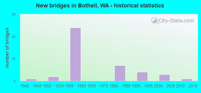
- New bridges - historical statistics
- 11940-1949
- 21950-1959
- 241960-1969
- 71980-1989
- 41990-1999
- 32000-2009
- 12010-2019
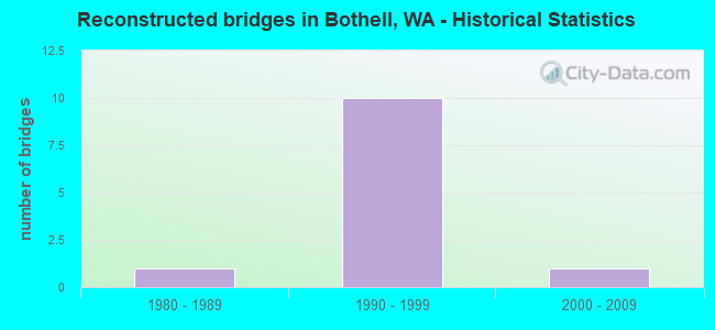
- Reconstructed bridges - Historical Statistics
- 11980-1989
- 101990-1999
- 12000-2009
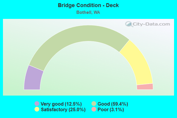
- Bridge Condition - Deck
- 12.5%Very good
- 59.4%Good
- 25.0%Satisfactory
- 3.1%Poor
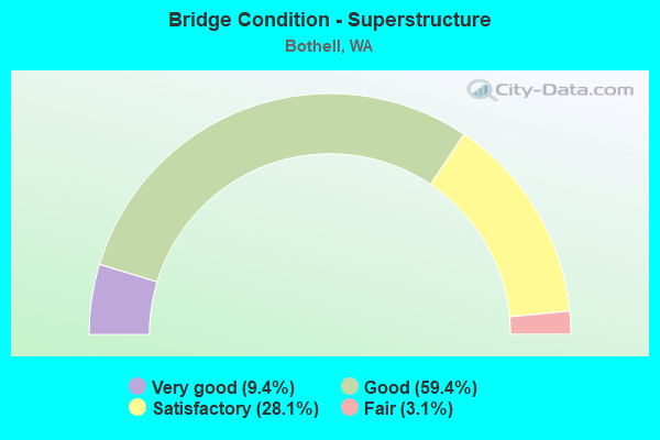
- Bridge Condition - Superstructure
- 9.4%Very good
- 59.4%Good
- 28.1%Satisfactory
- 3.1%Fair
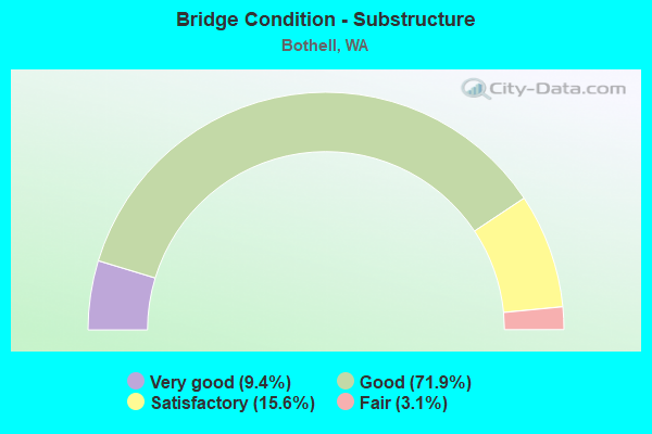
- Bridge Condition - Substructure
- 9.4%Very good
- 71.9%Good
- 15.6%Satisfactory
- 3.1%Fair
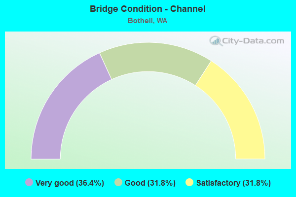
- Bridge Condition - Channel
- 36.4%Very good
- 31.8%Good
- 31.8%Satisfactory
Find on map >> Show street view
Structure Number: 13494A, Location: 1.0 E JCT I-405 (Lat: 47.758597, Lng: -122.163864), Route carried "under" structure: State highway 522, Year Built: 1989, Structure Length: 0. m, Average Daily Traffic: 65,961 (year 2019), Truck Traffic: 4%, Features Intersected: SR 522, Facility Carried by Structure: SR 202
Minimum Vertical Clearance: 6.63m (21.75ft), Kilometerpoint: 19.409, Lanes on structure: 5, Lanes under structure: 4, Material/Design: Prestressed concrete continuous, Design/Construction: Box Beam or Girders - Multiple, Length of Maximum Span: 43.0m (141.1ft)
Find on map >> Show street view
Structure Number: 17144A, Location: 1.6 N KING CO (Lat: 47.793861, Lng: -122.212389), Route carried "under" structure: Interstate 405, Year Built: 2007, Structure Length: 0. m, Average Daily Traffic: 98,501 (year 2019), Truck Traffic: 5%, Features Intersected: I-405, Facility Carried by Structure: CANYON PARK PED
Minimum Vertical Clearance: 6.17m (20.24ft), Kilometerpoint: 42.889, Lanes under structure: 11, Material/Design: Prestressed concrete continuous, Design/Construction: Box Beam or Girders - Single/Spread, Length of Maximum Span: 37.8m (124.0ft)