Bridge Statistics for Bozrah, Connecticut (CT)
Condition, Traffic, Stress, Structural Evaluation, Project Costs
- National Bridge Inventory (NBI) Statistics
- 22Number of bridges
- 210ft / 64.1mTotal length
- 159,288Total average daily traffic
- 8,815Total average daily truck traffic
- National Bridge Inventory (NBI) Registered Bridges for Bozrah
- No street view available for this location
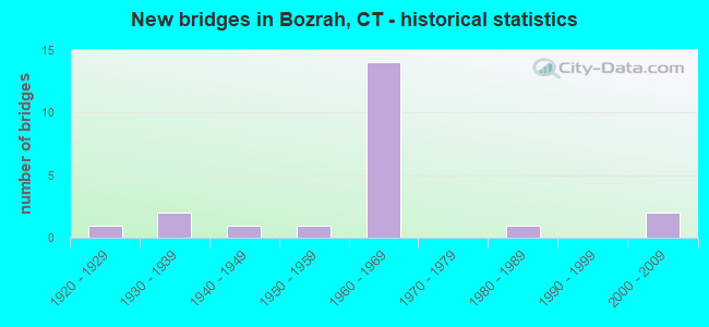
- New bridges - historical statistics
- 11920-1929
- 21930-1939
- 11940-1949
- 11950-1959
- 141960-1969
- 11980-1989
- 22000-2009

- Reconstructed bridges - Historical Statistics
- 11970-1979
- 71980-1989
- 21990-1999
- 22000-2009


- Bridge Condition - Deck
- 6.7%Very good
- 53.3%Good
- 33.3%Satisfactory
- 6.7%Fair

- Bridge Condition - Superstructure
- 6.3%Very good
- 43.8%Good
- 43.8%Satisfactory
- 6.3%Fair

- Bridge Condition - Substructure
- 43.8%Good
- 50.0%Satisfactory
- 6.3%Fair

- Bridge Condition - Channel
- 27.3%Good
- 63.6%Satisfactory
- 9.1%Fair
Find on map >> Show street view
Structure Number: 398, Location: 1.10 MI EAST LEBANON TL. (Lat: 41.570183, Lng: -72.183492), Route carried "on" structure: City street , Year Built: 1961, Year Reconstructed: 1999, Status: Open, Structure Length: 6.19m (20.31ft), Average Daily Traffic: 1,200 (year 2018), Truck Traffic: 7%, Average Future Daily Traffic: 1,783 (year 2038), Design Load: HS 20, Features Intersected: ROUTE 2, Facility Carried by Structure: BASHON HILL ROAD
Minimum Vertical Clearance: 30+ m (98+ ft), Kilometerpoint: 3.895, Lanes on structure: 2, Lanes under structure: 5, Owner: State Highway Agency, Approaching Roadway Width: 10.1m (33.1ft), Skew: 4 degrees, Material/Design: Steel continuous, Design/Construction: Stringer/Multi-beam, Number Of Spans In Main Unit: 2, Length of Maximum Span: 32.0m (105.0ft), Curb-To-Curb Width: 9.8m (32.2ft), Out-to-Out Width: 10.9m (35.8ft)
Condition: Deck: Good, Superstructure: Fair, Substructure: Fair, Operating Rating: 93.1 metric tons, Method Used To Determine Operating Rating: Load Factor (LF), Inventory Rating: 55.9 metric tons, Method Used To Determine Inventory Rating: Load Factor (LF), Structural Evaluation: Somewhat better than minimum adequacy, Deck Geometry: Somewhat better than minimum adequacy, Underclear: Meets minimum limits, Approach Roadway Alignment: Equal to present desirable criteria, Designated Inspection Frequency: Every 24 months, Inspection Date: May 2020, Deck Structure Type: Concrete Cast-file-Place, Wearing Surface/Protective System: Wearing Surface: Bituminous, Membrane: Built-up, Deck Protection: Epoxy Coated Reinforcing
Find on map >> Show street view
Structure Number: 399, Location: 1.88 MI WEST OF NORWICH (Lat: 41.562078, Lng: -72.165022), Route carried "on" structure: State highway 2, Year Built: 1961, Year Reconstructed: 1993, Status: Open, Structure Length: 3.69m (12.11ft), Average Daily Traffic: 13,100 (year 2018), Truck Traffic: 6%, Average Future Daily Traffic: 19,465 (year 2038), Design Load: HS 20, Features Intersected: ROUTE 163
Minimum Vertical Clearance: 30+ m (98+ ft), Kilometerpoint: 53.623, Lanes on structure: 3, Lanes under structure: 2, Base Highway Network: Yes, Owner: State Highway Agency, Approaching Roadway Width: 12.5m (41.0ft), Skew: 1 degrees, Material/Design: Steel, Design/Construction: Stringer/Multi-beam, Number Of Spans In Main Unit: 3, Length of Maximum Span: 14.0m (45.9ft), Curb-To-Curb Width: 15.5m (50.9ft), Out-to-Out Width: 16.7m (54.8ft)
Condition: Deck: Satisfactory, Superstructure: Satisfactory, Substructure: Good, Operating Rating: 61.6 metric tons, Method Used To Determine Operating Rating: Load and Resistance Factor Rating (LRFR) rating reported by rating factor(RF) method using HL-93 loadings, Inventory Rating: 47.3 metric tons, Method Used To Determine Inventory Rating: Load and Resistance Factor Rating (LRFR) rating reported by rating factor(RF) method using HL-93 loadings, Structural Evaluation: Equal to present minimum criteria, Deck Geometry: Equal to present minimum criteria, Underclear: Somewhat better than minimum adequacy, Approach Roadway Alignment: Equal to present desirable criteria, Designated Inspection Frequency: Every 24 months, Inspection Date: August 2021, Deck Structure Type: Concrete Cast-file-Place, Wearing Surface/Protective System: Wearing Surface: Bituminous, Membrane: Built-up, Deck Protection: Epoxy Coated Reinforcing
Find on map >> Show street view
Structure Number: 4, Location: 1.88 MI WEST OF NORWIC TL (Lat: 41.562286, Lng: -72.164983), Route carried "on" structure: State highway 2, Year Built: 1961, Year Reconstructed: 1993, Status: Open, Structure Length: 3.69m (12.11ft), Average Daily Traffic: 12,200 (year 2018), Truck Traffic: 6%, Average Future Daily Traffic: 18,128 (year 2038), Design Load: HS 20, Features Intersected: ROUTE 163
Minimum Vertical Clearance: 30+ m (98+ ft), Kilometerpoint: 53.623, Lanes on structure: 2, Lanes under structure: 2, Base Highway Network: Yes, Owner: State Highway Agency, Approaching Roadway Width: 11.9m (39.0ft), Skew: 1 degrees, Material/Design: Steel, Design/Construction: Stringer/Multi-beam, Number Of Spans In Main Unit: 3, Length of Maximum Span: 14.0m (45.9ft), Curb-To-Curb Width: 12.2m (40.0ft), Out-to-Out Width: 13.6m (44.6ft)
Condition: Deck: Good, Superstructure: Good, Substructure: Satisfactory, Operating Rating: 59.0 metric tons, Method Used To Determine Operating Rating: Load and Resistance Factor Rating (LRFR) rating reported by rating factor(RF) method using HL-93 loadings, Inventory Rating: 45.7 metric tons, Method Used To Determine Inventory Rating: Load and Resistance Factor Rating (LRFR) rating reported by rating factor(RF) method using HL-93 loadings, Structural Evaluation: Equal to present minimum criteria, Deck Geometry: Better than present minimum criteria, Underclear: Somewhat better than minimum adequacy, Approach Roadway Alignment: Equal to present desirable criteria, Designated Inspection Frequency: Every 24 months, Inspection Date: August 2021, Deck Structure Type: Concrete Cast-file-Place, Wearing Surface/Protective System: Wearing Surface: Bituminous, Membrane: Built-up, Deck Protection: Epoxy Coated Reinforcing
Find on map >> Show street view
Structure Number: 401, Location: 1.53MI WEST OF NORWICH TL (Lat: 41.560553, Lng: -72.158431), Route carried "on" structure: State highway 2, Year Built: 1961, Year Reconstructed: 1988, Status: Open, Structure Length: 8.45m (27.72ft), Average Daily Traffic: 13,300 (year 2018), Truck Traffic: 6%, Average Future Daily Traffic: 19,762 (year 2038), Design Load: H 20, Features Intersected: FITCHVLLE POND&BOZRAH ST
Minimum Vertical Clearance: 30+ m (98+ ft), Kilometerpoint: 54.171, Lanes on structure: 3, Lanes under structure: 2, Base Highway Network: Yes, Owner: State Highway Agency, Approaching Roadway Width: 14.9m (48.9ft), Skew: 4 degrees, Material/Design: Steel, Design/Construction: Stringer/Multi-beam, Number Of Spans In Main Unit: 4, Length of Maximum Span: 23.5m (77.1ft), Curb or Sidewalk Widths: Left: 0.5m (1.6ft), Right: 0.5m (1.6ft), Curb-To-Curb Width: 14.9m (48.9ft), Out-to-Out Width: 16.7m (54.8ft)
Condition: Deck: Satisfactory, Superstructure: Satisfactory, Substructure: Satisfactory, Channel: Good, Operating Rating: 79.9 metric tons, Method Used To Determine Operating Rating: Load Factor (LF), Inventory Rating: 48.0 metric tons, Method Used To Determine Inventory Rating: Load Factor (LF), Structural Evaluation: Equal to present minimum criteria, Deck Geometry: Meets minimum limits, Underclear: Meets minimum limits, Waterway Adequacy: Superior to present desirable criteria, Approach Roadway Alignment: Equal to present desirable criteria, Designated Inspection Frequency: Every 24 months, Underwater Inspection Frequency: Every 48 months, Inspection Date: October 2020, Underwater Inspection Date: May 2020, Deck Structure Type: Concrete Cast-file-Place, Wearing Surface/Protective System: Wearing Surface: Bituminous, Membrane: Preformed Fabric
Find on map >> Show street view
Structure Number: 402, Location: 1.53MI WEST OF NORWICH TL (Lat: 41.560753, Lng: -72.158139), Route carried "on" structure: State highway 2, Year Built: 1961, Year Reconstructed: 1988, Status: Open, Structure Length: 8.90m (29.20ft), Average Daily Traffic: 27,000 (year 2018), Truck Traffic: 6%, Average Future Daily Traffic: 40,119 (year 2038), Design Load: HS 20, Features Intersected: FITCHVLLE POND&BOZRAH ST
Minimum Vertical Clearance: 30+ m (98+ ft), Kilometerpoint: 54.187, Lanes on structure: 2, Lanes under structure: 2, Base Highway Network: Yes, Owner: State Highway Agency, Approaching Roadway Width: 11.3m (37.1ft), Skew: 9 degrees, Material/Design: Steel, Design/Construction: Stringer/Multi-beam, Number Of Spans In Main Unit: 4, Length of Maximum Span: 24.7m (81.0ft), Curb or Sidewalk Widths: Left: 0.5m (1.6ft), Right: 0.5m (1.6ft), Curb-To-Curb Width: 11.9m (39.0ft), Out-to-Out Width: 13.7m (44.9ft)
Condition: Deck: Satisfactory, Superstructure: Satisfactory, Substructure: Satisfactory, Channel: Good, Operating Rating: 80.0 metric tons, Method Used To Determine Operating Rating: Load Factor (LF), Inventory Rating: 48.0 metric tons, Method Used To Determine Inventory Rating: Load Factor (LF), Structural Evaluation: Equal to present minimum criteria, Deck Geometry: Equal to present minimum criteria, Underclear: Meets minimum limits, Waterway Adequacy: Superior to present desirable criteria, Approach Roadway Alignment: Equal to present desirable criteria, Designated Inspection Frequency: Every 24 months, Underwater Inspection Frequency: Every 48 months, Inspection Date: October 2020, Underwater Inspection Date: May 2020, Deck Structure Type: Concrete Cast-file-Place, Wearing Surface/Protective System: Wearing Surface: Bituminous, Membrane: Preformed Fabric
Find on map >> Show street view
Structure Number: 403, Location: .67 MI WEST OF NORWICH TL (Lat: 41.565372, Lng: -72.143414), Route carried "on" structure: State highway 2, Year Built: 1961, Year Reconstructed: 1992, Status: Open, Structure Length: 4.08m (13.39ft), Average Daily Traffic: 13,700 (year 2018), Truck Traffic: 6%, Average Future Daily Traffic: 20,357 (year 2038), Design Load: HS 20, Features Intersected: SR 608 NWCH/CLCHST
Minimum Vertical Clearance: 30+ m (98+ ft), Kilometerpoint: 55.571, Lanes on structure: 2, Lanes under structure: 2, Base Highway Network: Yes, Owner: State Highway Agency, Approaching Roadway Width: 12.5m (41.0ft), Skew: 3 degrees, Material/Design: Steel, Design/Construction: Stringer/Multi-beam, Number Of Spans In Main Unit: 3, Length of Maximum Span: 15.9m (52.2ft), Curb-To-Curb Width: 12.5m (41.0ft), Out-to-Out Width: 13.7m (44.9ft)
Condition: Deck: Good, Superstructure: Satisfactory, Substructure: Good, Operating Rating: 42.1 metric tons, Method Used To Determine Operating Rating: Load and Resistance Factor Rating (LRFR) rating reported by rating factor(RF) method using HL-93 loadings, Inventory Rating: 32.7 metric tons, Method Used To Determine Inventory Rating: Load and Resistance Factor Rating (LRFR) rating reported by rating factor(RF) method using HL-93 loadings, Structural Evaluation: Equal to present minimum criteria, Deck Geometry: Better than present minimum criteria, Underclear: Meets minimum limits, Approach Roadway Alignment: Equal to present desirable criteria, Designated Inspection Frequency: Every 24 months, Inspection Date: June 2021, Deck Structure Type: Concrete Cast-file-Place, Wearing Surface/Protective System: Wearing Surface: Bituminous, Membrane: Built-up, Deck Protection: Epoxy Coated Reinforcing
Find on map >> Show street view
Structure Number: 404, Location: .67 MI WEST OF NORWICH TL (Lat: 41.565531, Lng: -72.143658), Route carried "on" structure: State highway 2, Year Built: 1961, Year Reconstructed: 1992, Status: Open, Structure Length: 4.08m (13.39ft), Average Daily Traffic: 13,300 (year 2018), Truck Traffic: 6%, Average Future Daily Traffic: 19,762 (year 2038), Design Load: HS 20, Features Intersected: SR 608 NWCH/CLCHST
Minimum Vertical Clearance: 30+ m (98+ ft), Kilometerpoint: 55.571, Lanes on structure: 3, Lanes under structure: 2, Base Highway Network: Yes, Owner: State Highway Agency, Approaching Roadway Width: 12.8m (42.0ft), Skew: 3 degrees, Material/Design: Steel, Design/Construction: Stringer/Multi-beam, Number Of Spans In Main Unit: 3, Length of Maximum Span: 15.9m (52.2ft), Curb-To-Curb Width: 13.7m (44.9ft), Out-to-Out Width: 14.9m (48.9ft)
Condition: Deck: Good, Superstructure: Satisfactory, Substructure: Good, Operating Rating: 39.5 metric tons, Method Used To Determine Operating Rating: Load and Resistance Factor Rating (LRFR) rating reported by rating factor(RF) method using HL-93 loadings, Inventory Rating: 30.5 metric tons, Method Used To Determine Inventory Rating: Load and Resistance Factor Rating (LRFR) rating reported by rating factor(RF) method using HL-93 loadings, Structural Evaluation: Equal to present minimum criteria, Deck Geometry: Somewhat better than minimum adequacy, Underclear: Meets minimum limits, Approach Roadway Alignment: Equal to present desirable criteria, Designated Inspection Frequency: Every 24 months, Inspection Date: June 2021, Deck Structure Type: Concrete Cast-file-Place, Wearing Surface/Protective System: Wearing Surface: Bituminous, Membrane: Built-up, Deck Protection: Epoxy Coated Reinforcing
Find on map >> Show street view
Structure Number: 459, Location: 75' EAST OF DANBURY TL (Lat: 41.416025, Lng: -73.405061), Route carried "on" structure: US 6, Year Built: 1962, Year Reconstructed: 1989, Status: Open, Structure Length: 8.96m (29.40ft), Average Daily Traffic: 18,400 (year 2016), Truck Traffic: 5%, Average Future Daily Traffic: 27,341 (year 2036), Design Load: HS 20, Features Intersected: INTERSTATE-84
Minimum Vertical Clearance: 30+ m (98+ ft), Kilometerpoint: 14.098, Lanes on structure: 3, Lanes under structure: 6, Owner: State Highway Agency, Approaching Roadway Width: 12.2m (40.0ft), Skew: 4 degrees, Material/Design: Steel, Design/Construction: Stringer/Multi-beam, Number Of Spans In Main Unit: 4, Length of Maximum Span: 33.2m (108.9ft), Curb or Sidewalk Widths: Left: 1.5m (4.9ft), Right: 0.0m, Curb-To-Curb Width: 12.2m (40.0ft), Out-to-Out Width: 14.7m (48.2ft)
Condition: Deck: Satisfactory, Superstructure: Satisfactory, Substructure: Good, Operating Rating: 78.6 metric tons, Method Used To Determine Operating Rating: Load Factor (LF), Inventory Rating: 47.2 metric tons, Method Used To Determine Inventory Rating: Load Factor (LF), Structural Evaluation: Equal to present minimum criteria, Deck Geometry: Meets minimum limits, Underclear: High priority of corrective action, Approach Roadway Alignment: Equal to present minimum criteria, Designated Inspection Frequency: Every 24 months, Inspection Date: September 2021, Deck Structure Type: Concrete Cast-file-Place, Wearing Surface/Protective System: Wearing Surface: Bituminous, Membrane: Preformed Fabric, Deck Protection: Epoxy Coated Reinforcing
Find on map >> Show street view
Structure Number: 1407, Location: 1.65 MI. SO. OF RTE 2 EB (Lat: 41.544078, Lng: -72.179425), Route carried "on" structure: State highway 163, Year Built: 1925, Status: Open, Structure Length: 0.98m (3.22ft), Average Daily Traffic: 2,200 (year 2017), Truck Traffic: 3%, Average Future Daily Traffic: 3,269 (year 2037), Design Load: HS 15, Features Intersected: PEARSONS BROOK
Minimum Vertical Clearance: 30+ m (98+ ft), Kilometerpoint: 17.944, Lanes on structure: 2, Owner: State Highway Agency, Approaching Roadway Width: 7.3m (24.0ft), Material/Design: Steel, Design/Construction: Stringer/Multi-beam, Number Of Spans In Main Unit: 1, Length of Maximum Span: 7.9m (25.9ft), Curb-To-Curb Width: 8.7m (28.5ft), Out-to-Out Width: 9.4m (30.8ft)
Condition: Deck: Fair, Superstructure: Satisfactory, Substructure: Satisfactory, Channel: Satisfactory, Operating Rating: 61.7 metric tons, Method Used To Determine Operating Rating: Load Factor (LF), Inventory Rating: 53.5 metric tons, Method Used To Determine Inventory Rating: Load Factor (LF), Structural Evaluation: Equal to present minimum criteria, Deck Geometry: Meets minimum limits, Waterway Adequacy: Equal to present minimum criteria, Approach Roadway Alignment: Equal to present desirable criteria, Designated Inspection Frequency: Every 24 months, Inspection Date: August 2020, Deck Structure Type: Concrete Cast-file-Place, Wearing Surface/Protective System: Wearing Surface: Bituminous, Membrane: Preformed Fabric
Find on map >> Show street view
Structure Number: 1632, Location: 1.49 MI EAST OF BOZRAH TL (Lat: 41.570067, Lng: -72.175789), Route carried "on" structure: State highway 608, Year Built: 1941, Year Reconstructed: 1999, Status: Open, Structure Length: 2.50m (8.20ft), Average Daily Traffic: 1,200 (year 2017), Truck Traffic: 2%, Average Future Daily Traffic: 1,783 (year 2037), Design Load: HS 20, Features Intersected: YANTIC RIVER
Minimum Vertical Clearance: 30+ m (98+ ft), Kilometerpoint: 2.720, Lanes on structure: 2, Base Highway Network: Yes, Owner: State Highway Agency, Approaching Roadway Width: 10.0m (32.8ft), Skew: 1 degrees, Material/Design: Prestressed concrete, Design/Construction: Box Beam or Girders - Multiple, Number Of Spans In Main Unit: 1, Length of Maximum Span: 23.2m (76.1ft), Curb-To-Curb Width: 10.0m (32.8ft), Out-to-Out Width: 11.1m (36.4ft)
Condition: Deck: Satisfactory, Superstructure: Good, Substructure: Good, Channel: Satisfactory, Operating Rating: 73.6 metric tons, Method Used To Determine Operating Rating: Load Factor (LF), Inventory Rating: 44.1 metric tons, Method Used To Determine Inventory Rating: Load Factor (LF), Structural Evaluation: Better than present minimum criteria, Deck Geometry: Somewhat better than minimum adequacy, Waterway Adequacy: Equal to present minimum criteria, Approach Roadway Alignment: Equal to present desirable criteria, Designated Inspection Frequency: Every 24 months, Inspection Date: May 2021, Deck Structure Type: Other, Wearing Surface/Protective System: Wearing Surface: Bituminous, Membrane: Built-up, Deck Protection: Epoxy Coated Reinforcing
Find on map >> Show street view
Structure Number: 1634, Location: 0.5 MI NORTH OF ROUTE 2 (Lat: 41.563964, Lng: -72.164614), Route carried "on" structure: State highway 612, Year Built: 2002, Status: Open, Structure Length: 3.72m (12.20ft), Average Daily Traffic: 1,900 (year 2017), Truck Traffic: 2%, Average Future Daily Traffic: 2,823 (year 2037), Design Load: HS 20, Features Intersected: FITCHVILLE POND
Minimum Vertical Clearance: 30+ m (98+ ft), Kilometerpoint: 0.097, Lanes on structure: 2, Owner: State Highway Agency, Approaching Roadway Width: 12.5m (41.0ft), Material/Design: Prestressed concrete, Design/Construction: Box Beam or Girders - Multiple, Number Of Spans In Main Unit: 2, Length of Maximum Span: 18.0m (59.1ft), Curb-To-Curb Width: 12.4m (40.7ft), Out-to-Out Width: 13.6m (44.6ft)
Condition: Deck: Good, Superstructure: Good, Substructure: Satisfactory, Channel: Fair, Operating Rating: 69.1 metric tons, Method Used To Determine Operating Rating: Load Factor (LF), Inventory Rating: 41.4 metric tons, Method Used To Determine Inventory Rating: Load Factor (LF), Structural Evaluation: Equal to present minimum criteria, Deck Geometry: Better than present minimum criteria, Waterway Adequacy: Equal to present minimum criteria, Approach Roadway Alignment: Equal to present desirable criteria, Designated Inspection Frequency: Every 24 months, Inspection Date: July 2021, Deck Structure Type: Other, Wearing Surface/Protective System: Wearing Surface: Bituminous, Membrane: Built-up, Deck Protection: Epoxy Coated Reinforcing
Find on map >> Show street view
Structure Number: 4172, Location: 0.49 MI WEST OF SR 612 (Lat: 41.564017, Lng: -72.155447), Route carried "on" structure: State highway 608, Year Built: 1934, Year Reconstructed: 1978, Status: Open, Structure Length: 2.71m (8.89ft), Average Daily Traffic: 2,800 (year 2015), Truck Traffic: 2%, Average Future Daily Traffic: 4,161 (year 2035), Design Load: HS 20, Features Intersected: YANTIC RIVER
Minimum Vertical Clearance: 30+ m (98+ ft), Kilometerpoint: 4.651, Lanes on structure: 2, Owner: State Highway Agency, Approaching Roadway Width: 8.5m (27.9ft), Skew: 3 degrees, Material/Design: Prestressed concrete, Design/Construction: Box Beam or Girders - Multiple, Number Of Spans In Main Unit: 1, Length of Maximum Span: 26.2m (86.0ft), Curb or Sidewalk Widths: Left: 1.2m (3.9ft), Right: 0.0m, Curb-To-Curb Width: 8.5m (27.9ft), Out-to-Out Width: 9.8m (32.2ft)
Condition: Deck: Good, Superstructure: Good, Substructure: Satisfactory, Channel: Satisfactory, Inventory Rating: 68.9 metric tons, Method Used To Determine Inventory Rating: Load Factor (LF), Structural Evaluation: Equal to present minimum criteria, Deck Geometry: Meets minimum limits, Waterway Adequacy: Equal to present desirable criteria, Approach Roadway Alignment: Somewhat better than minimum adequacy, Designated Inspection Frequency: Every 24 months, Inspection Date: January 2020, Deck Structure Type: Other, Wearing Surface/Protective System: Wearing Surface: Bituminous, Membrane: Built-up
Find on map >> Show street view
Structure Number: 4587, Location: 400 FT SE OF ROUTE 163 (Lat: 41.543169, Lng: -72.173631), Route carried "on" structure: City street , Year Built: 2001, Status: Open, Structure Length: 0.88m (2.89ft), Average Daily Traffic: 476 (year 2019), Truck Traffic: 7%, Average Future Daily Traffic: 707 (year 2039), Design Load: HS 20, Features Intersected: GARDNER BROOK, Facility Carried by Structure: BISHOP ROAD
Minimum Vertical Clearance: 30+ m (98+ ft), Kilometerpoint: 1.899, Lanes on structure: 2, Owner: Town or Township Highway Agency, Approaching Roadway Width: 7.0m (23.0ft), Material/Design: Concrete, Design/Construction: Culvert, Number Of Spans In Main Unit: 3, Length of Maximum Span: 3.0m (9.8ft), Curb-To-Curb Width: 6.7m (22.0ft), Out-to-Out Width: 8.1m (26.6ft)
Condition: Channel: Good, Culverts: Satisfactory, Operating Rating: 42.6 metric tons, Method Used To Determine Operating Rating: Field evaluation and documented engineering judgment, Inventory Rating: 32.7 metric tons, Method Used To Determine Inventory Rating: Field evaluation and documented engineering judgment, Structural Evaluation: Equal to present minimum criteria, Deck Geometry: Meets minimum limits, Waterway Adequacy: Better than present minimum criteria, Approach Roadway Alignment: Equal to present desirable criteria, Designated Inspection Frequency: Every 24 months, Inspection Date: Febuary 2021, Deck Structure Type: Other, Wearing Surface/Protective System: Wearing Surface: Bituminous
Find on map >> Show street view
Structure Number: 4589, Location: 700 FT E OF ROUTE 163 (Lat: 41.559672, Lng: -72.159569), Route carried "on" structure: City street , Year Built: 1930, Year Reconstructed: 2006, Status: Open, Structure Length: 0.82m (2.69ft), Average Daily Traffic: 2,680 (year 2021), Truck Traffic: 4%, Average Future Daily Traffic: 3,982 (year 2041), Design Load: HS 20, Features Intersected: FITCHVILLE POND, Facility Carried by Structure: BOZRAH STREET EXT
Minimum Vertical Clearance: 30+ m (98+ ft), Kilometerpoint: 1.030, Lanes on structure: 2, Owner: Town or Township Highway Agency, Approaching Roadway Width: 9.1m (29.9ft), Skew: 1 degrees, Material/Design: Prestressed concrete, Design/Construction: Slab, Number Of Spans In Main Unit: 1, Length of Maximum Span: 6.7m (22.0ft), Curb or Sidewalk Widths: Left: 0.0m, Right: 1.4m (4.6ft), Curb-To-Curb Width: 9.1m (29.9ft), Out-to-Out Width: 12.1m (39.7ft)
Condition: Deck: Good, Superstructure: Good, Substructure: Satisfactory, Channel: Satisfactory, Inventory Rating: 79.7 metric tons, Method Used To Determine Inventory Rating: Load Factor (LF), Structural Evaluation: Equal to present minimum criteria, Deck Geometry: Meets minimum limits, Waterway Adequacy: Better than present minimum criteria, Approach Roadway Alignment: Equal to present minimum criteria, Designated Inspection Frequency: Every 24 months, Underwater Inspection Frequency: Every 24 months, Inspection Date: January 2021, Underwater Inspection Date: January 2021, Deck Structure Type: Other, Wearing Surface/Protective System: Wearing Surface: Bituminous, Membrane: Built-up, Deck Protection: Epoxy Coated Reinforcing
Find on map >> Show street view
Structure Number: 459, Location: 600 FT N OF ROUTE 608 (Lat: 41.575950, Lng: -72.191056), Route carried "on" structure: City street , Year Built: 1957, Year Reconstructed: 2011, Status: Open, Structure Length: 1.62m (5.31ft), Average Daily Traffic: 386 (year 2019), Truck Traffic: 7%, Average Future Daily Traffic: 574 (year 2039), Design Load: HL 93, Features Intersected: YANTIC RIVER, Facility Carried by Structure: STANTON ROAD
Minimum Vertical Clearance: 30+ m (98+ ft), Kilometerpoint: 1.159, Lanes on structure: 2, Owner: Town or Township Highway Agency, Approaching Roadway Width: 6.7m (22.0ft), Skew: 3 degrees, Material/Design: Prestressed concrete, Design/Construction: Box Beam or Girders - Multiple, Number Of Spans In Main Unit: 1, Length of Maximum Span: 15.5m (50.9ft), Curb-To-Curb Width: 6.7m (22.0ft), Out-to-Out Width: 7.9m (25.9ft)
Condition: Deck: Very good, Superstructure: Very good, Substructure: Good, Channel: Satisfactory, Operating Rating: 58.3 metric tons, Method Used To Determine Operating Rating: Load and Resistance Factor Rating (LRFR) rating reported by rating factor(RF) method using HL-93 loadings, Inventory Rating: 45.0 metric tons, Method Used To Determine Inventory Rating: Load and Resistance Factor Rating (LRFR) rating reported by rating factor(RF) method using HL-93 loadings, Structural Evaluation: Better than present minimum criteria, Deck Geometry: Meets minimum limits, Waterway Adequacy: Better than present minimum criteria, Approach Roadway Alignment: Equal to present desirable criteria, Designated Inspection Frequency: Every 24 months, Inspection Date: Febuary 2021, Deck Structure Type: Other, Wearing Surface/Protective System: Wearing Surface: Bituminous, Membrane: Built-up, Deck Protection: Epoxy Coated Reinforcing
Find on map >> Show street view
Structure Number: 4591, Location: 75 FT N OF GILMAN ROAD (Lat: 41.579408, Lng: -72.197378), Route carried "on" structure: City street , Year Built: 1963, Status: Open, Structure Length: 1.95m (6.40ft), Average Daily Traffic: 385 (year 2019), Truck Traffic: 7%, Average Future Daily Traffic: 572 (year 2039), Design Load: HS 20, Features Intersected: YANTIC RIVER, Facility Carried by Structure: STANTON HILL RD EX
Minimum Vertical Clearance: 30+ m (98+ ft), Kilometerpoint: 2.350, Lanes on structure: 2, Owner: Town or Township Highway Agency, Approaching Roadway Width: 7.6m (24.9ft), Material/Design: Steel, Design/Construction: Stringer/Multi-beam, Number Of Spans In Main Unit: 1, Length of Maximum Span: 18.3m (60.0ft), Curb or Sidewalk Widths: Left: 1.5m (4.9ft), Right: 0.5m (1.6ft), Curb-To-Curb Width: 6.7m (22.0ft), Out-to-Out Width: 8.7m (28.5ft)
Condition: Deck: Good, Superstructure: Good, Substructure: Satisfactory, Channel: Satisfactory, Operating Rating: 70.8 metric tons, Method Used To Determine Operating Rating: Load Factor (LF), Inventory Rating: 42.4 metric tons, Method Used To Determine Inventory Rating: Load Factor (LF), Structural Evaluation: Equal to present minimum criteria, Deck Geometry: Meets minimum limits, Waterway Adequacy: Better than present minimum criteria, Approach Roadway Alignment: Better than present minimum criteria, Designated Inspection Frequency: Every 24 months, Inspection Date: Febuary 2021, Deck Structure Type: Concrete Cast-file-Place, Wearing Surface/Protective System: Wearing Surface: Monolithic Concrete
Find on map >> Show street view
Structure Number: 5517, Location: 500 FT. EAST OF ROUTE 163 (Lat: 41.551500, Lng: -72.166242), Route carried "on" structure: City street , Year Built: 1984, Status: Open, Structure Length: 0.88m (2.89ft), Average Daily Traffic: 261 (year 2019), Truck Traffic: 7%, Average Future Daily Traffic: 388 (year 2039), Features Intersected: GARDNER BROOK, Facility Carried by Structure: GAGER ROAD
Minimum Vertical Clearance: 30+ m (98+ ft), Kilometerpoint: 1.287, Lanes on structure: 2, Owner: Town or Township Highway Agency, Approaching Roadway Width: 8.8m (28.9ft), Material/Design: Concrete, Design/Construction: Arch - Deck, Number Of Spans In Main Unit: 1, Length of Maximum Span: 8.8m (28.9ft), Curb-To-Curb Width: 7.0m (23.0ft), Out-to-Out Width: 8.0m (26.2ft)
Condition: Superstructure: Good, Substructure: Good, Channel: Satisfactory, Operating Rating: 42.6 metric tons, Method Used To Determine Operating Rating: Field evaluation and documented engineering judgment, Inventory Rating: 32.7 metric tons, Method Used To Determine Inventory Rating: Field evaluation and documented engineering judgment, Structural Evaluation: Better than present minimum criteria, Deck Geometry: Meets minimum limits, Waterway Adequacy: Better than present minimum criteria, Approach Roadway Alignment: Better than present minimum criteria, Designated Inspection Frequency: Every 24 months, Inspection Date: Febuary 2021
Find on map >> Show street view
Structure Number: 398, Location: 1.10 MI EAST LEBANON TL. (Lat: 41.570183, Lng: -72.183492), Route carried "under" structure: State highway 2, Year Built: 1961, Structure Length: 0. m, Average Daily Traffic: 25,800 (year 2018), Truck Traffic: 6%, Features Intersected: ROUTE 2, Facility Carried by Structure: BASHON HILL ROAD
Minimum Vertical Clearance: 7.19m (23.59ft), Kilometerpoint: 51.837, Lanes on structure: 2, Lanes under structure: 5, Material/Design: Steel continuous, Design/Construction: Stringer/Multi-beam, Length of Maximum Span: 32.0m (105.0ft)
Find on map >> Show street view
Structure Number: 399, Location: 1.88 MI WEST OF NORWICH (Lat: 41.562078, Lng: -72.165022), Route carried "under" structure: State highway 163, Year Built: 1961, Structure Length: 0. m, Average Daily Traffic: 2,300 (year 2017), Truck Traffic: 2%, Features Intersected: ROUTE 163, Facility Carried by Structure: ROUTE 2 EASTBOUND
Minimum Vertical Clearance: 5.00m (16.40ft), Kilometerpoint: 20.600, Lanes on structure: 3, Lanes under structure: 2, Material/Design: Steel, Design/Construction: Stringer/Multi-beam, Length of Maximum Span: 14.0m (45.9ft)
Find on map >> Show street view
Structure Number: 4, Location: 1.88 MI WEST OF NORWIC TL (Lat: 41.562286, Lng: -72.164983), Route carried "under" structure: State highway 163, Year Built: 1961, Structure Length: 0. m, Average Daily Traffic: 2,300 (year 2017), Truck Traffic: 2%, Features Intersected: ROUTE 163, Facility Carried by Structure: ROUTE 2 WESTBOUND
Minimum Vertical Clearance: 5.59m (18.34ft), Kilometerpoint: 20.632, Lanes on structure: 2, Lanes under structure: 2, Material/Design: Steel, Design/Construction: Stringer/Multi-beam, Length of Maximum Span: 14.0m (45.9ft)
Find on map >> Show street view
Structure Number: 403, Location: .67 MI WEST OF NORWICH TL (Lat: 41.565372, Lng: -72.143414), Route carried "under" structure: State highway 608, Year Built: 1961, Structure Length: 0. m, Average Daily Traffic: 2,200 (year 2017), Truck Traffic: 5%, Features Intersected: SR 608 NWCH/CLCHST, Facility Carried by Structure: ROUTE 2 EASTBOUND
Minimum Vertical Clearance: 4.57m (14.99ft), Kilometerpoint: 5.890, Lanes on structure: 2, Lanes under structure: 2, Material/Design: Steel, Design/Construction: Stringer/Multi-beam, Length of Maximum Span: 15.9m (52.2ft)
Find on map >> Show street view
Structure Number: 404, Location: .67 MI WEST OF NORWICH TL (Lat: 41.565531, Lng: -72.143658), Route carried "under" structure: State highway 608, Year Built: 1961, Structure Length: 0. m, Average Daily Traffic: 2,200 (year 2017), Truck Traffic: 5%, Features Intersected: SR 608 NWCH/CLCHST, Facility Carried by Structure: ROUTE 2 WESTBOUND
Minimum Vertical Clearance: 5.46m (17.91ft), Kilometerpoint: 5.858, Lanes on structure: 3, Lanes under structure: 2, Material/Design: Steel, Design/Construction: Stringer/Multi-beam, Length of Maximum Span: 15.9m (52.2ft)