Bozrah, Connecticut
Submit your own pictures of this town and show them to the world
- OSM Map
- Google Map
- MSN Map
Population change since 2000: +11.5%
 |
| Males: 1,327 | |
| Females: 1,300 |
| Median resident age: | 43.9 years |
| Connecticut median age: | 39.2 years |
Zip codes: 06334.
| Bozrah: | $93,551 |
| CT: | $88,429 |
Estimated per capita income in 2022: $47,642 (it was $26,569 in 2000)
Bozrah town income, earnings, and wages data
Estimated median house or condo value in 2022: $315,204 (it was $145,800 in 2000)
| Bozrah: | $315,204 |
| CT: | $347,200 |
Mean prices in 2022: all housing units: $336,024; detached houses: $358,368; townhouses or other attached units: $232,367; in 2-unit structures: $294,123; in 3-to-4-unit structures: $234,423; in 5-or-more-unit structures: $212,293; mobile homes: $38,564; occupied boats, rvs, vans, etc.: $86,722
Detailed information about poverty and poor residents in Bozrah, CT


- 2,44593.1%White alone
- 913.5%Hispanic
- 381.4%Two or more races
- 291.1%Black alone
- 130.5%Asian alone
- 90.3%American Indian alone
- 20.08%Other race alone
Races in Bozrah detailed stats: ancestries, foreign born residents, place of birth
According to our research of Connecticut and other state lists, there were 4 registered sex offenders living in Bozrah, Connecticut as of May 21, 2024.
The ratio of all residents to sex offenders in Bozrah is 657 to 1.
The ratio of registered sex offenders to all residents in this city is near the state average.
 Recent articles from our blog. Our writers, many of them Ph.D. graduates or candidates, create easy-to-read articles on a wide variety of topics.

Ancestries: English (16.8%), Polish (16.4%), Irish (16.2%), French (11.5%), Italian (11.5%), United States (9.2%).
Current Local Time: EST time zone
Incorporated on 05/1786
Land area: 20.0 square miles.
Population density: 132 people per square mile (very low).
64 residents are foreign born (1.6% Europe, 0.6% Latin America, 0.5% North America).
| This town: | 2.7% |
| Connecticut: | 10.9% |
| Bozrah town: | 1.3% ($1,881) |
| Connecticut: | 1.8% ($2,961) |
Nearest city with pop. 50,000+: Manchester, CT  (23.8 miles , pop. 54,740).
Nearest city with pop. 200,000+: Boston, MA (77.5 miles , pop. 589,141).
Nearest city with pop. 1,000,000+: Bronx, NY (100.6 miles , pop. 1,332,650).
Nearest cities:
), ), ), ), )Latitude: 41.55 N, Longitude: 72.18 W
Area code commonly used in this area: 860
Single-family new house construction building permits:
- 2022: 3 buildings, average cost: $408,300
- 2021: 1 building, cost: $156,100
- 2020: 2 buildings, average cost: $376,000
- 2019: 2 buildings, average cost: $201,000
- 2018: 1 building, cost: $300,000
- 2016: 1 building, cost: $325,000
- 2014: 2 buildings, average cost: $172,000
- 2013: 1 building, cost: $200,000
- 2012: 3 buildings, average cost: $133,300
- 2011: 2 buildings, average cost: $135,000
- 2010: 4 buildings, average cost: $154,800
- 2009: 1 building, cost: $388,000
- 2008: 2 buildings, average cost: $148,500
- 2007: 8 buildings, average cost: $181,400
- 2006: 12 buildings, average cost: $169,700
- 2005: 9 buildings, average cost: $171,900
- 2004: 11 buildings, average cost: $166,400
- 2003: 11 buildings, average cost: $170,900
- 2002: 9 buildings, average cost: $151,100
- 2001: 13 buildings, average cost: $182,700
- 2000: 11 buildings, average cost: $132,200
- 1999: 15 buildings, average cost: $114,700
- 1998: 6 buildings, average cost: $92,500
- 1997: 5 buildings, average cost: $95,600
| Here: | 2.9% |
| Connecticut: | 3.9% |
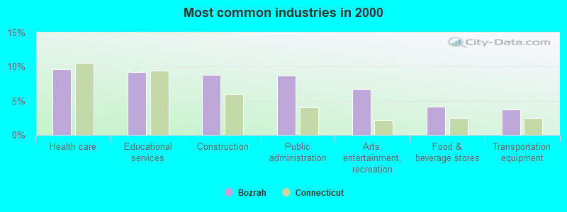
- Health care (9.6%)
- Educational services (9.2%)
- Construction (8.8%)
- Public administration (8.7%)
- Arts, entertainment, recreation (6.7%)
- Food & beverage stores (4.1%)
- Transportation equipment (3.7%)
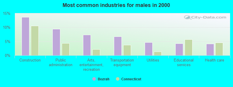
- Construction (13.6%)
- Public administration (9.4%)
- Arts, entertainment, recreation (7.3%)
- Transportation equipment (6.7%)
- Utilities (4.7%)
- Educational services (4.2%)
- Health care (4.1%)
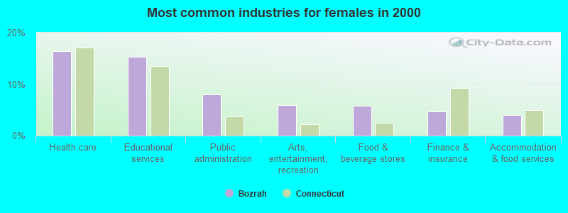
- Health care (16.5%)
- Educational services (15.4%)
- Public administration (8.0%)
- Arts, entertainment, recreation (6.0%)
- Food & beverage stores (5.8%)
- Finance & insurance (4.7%)
- Accommodation & food services (4.0%)
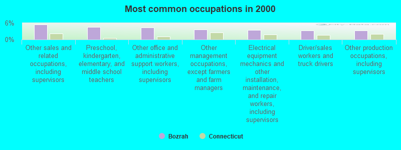
- Other sales and related occupations, including supervisors (5.4%)
- Preschool, kindergarten, elementary, and middle school teachers (4.6%)
- Other office and administrative support workers, including supervisors (4.4%)
- Other management occupations, except farmers and farm managers (3.6%)
- Electrical equipment mechanics and other installation, maintenance, and repair workers, including supervisors (3.4%)
- Driver/sales workers and truck drivers (3.3%)
- Other production occupations, including supervisors (3.3%)
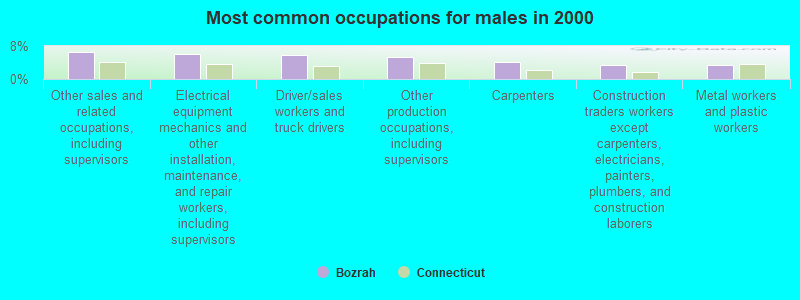
- Other sales and related occupations, including supervisors (6.4%)
- Electrical equipment mechanics and other installation, maintenance, and repair workers, including supervisors (6.1%)
- Driver/sales workers and truck drivers (5.7%)
- Other production occupations, including supervisors (5.3%)
- Carpenters (4.1%)
- Construction traders workers except carpenters, electricians, painters, plumbers, and construction laborers (3.5%)
- Metal workers and plastic workers (3.4%)
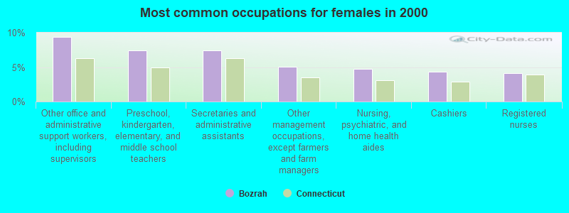
- Other office and administrative support workers, including supervisors (9.4%)
- Preschool, kindergarten, elementary, and middle school teachers (7.4%)
- Secretaries and administrative assistants (7.4%)
- Other management occupations, except farmers and farm managers (5.1%)
- Nursing, psychiatric, and home health aides (4.7%)
- Cashiers (4.3%)
- Registered nurses (4.2%)
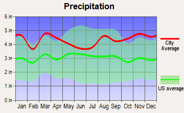
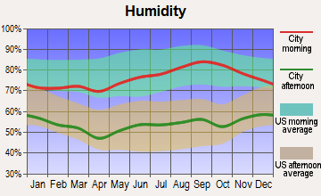
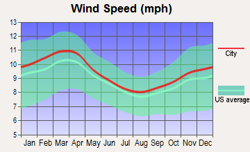
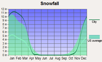
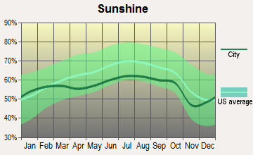
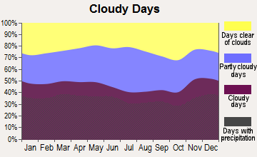
Average climate in Bozrah, Connecticut
Based on data reported by over 4,000 weather stations
(lower is better)
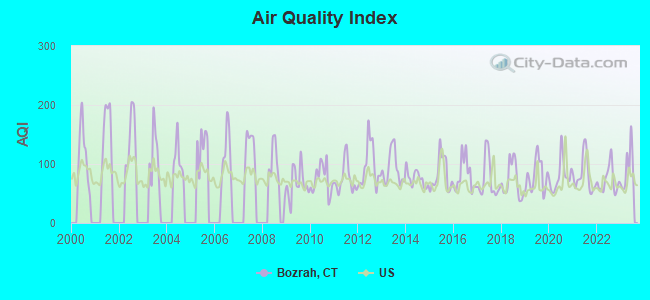
Air Quality Index (AQI) level in 2023 was 91.8. This is worse than average.
| City: | 91.8 |
| U.S.: | 72.6 |
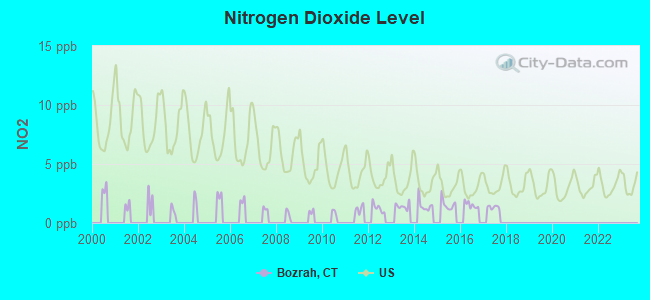
Nitrogen Dioxide (NO2) [ppb] level in 2017 was 1.35. This is significantly better than average. Closest monitor was 5.7 miles away from the city center.
| City: | 1.35 |
| U.S.: | 5.11 |
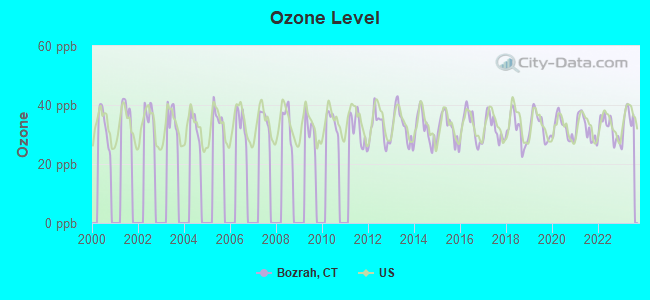
Ozone [ppb] level in 2023 was 34.8. This is about average. Closest monitor was 13.9 miles away from the city center.
| City: | 34.8 |
| U.S.: | 33.3 |
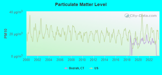
Particulate Matter (PM10) [µg/m3] level in 2022 was 12.6. This is significantly better than average. Closest monitor was 5.6 miles away from the city center.
| City: | 12.6 |
| U.S.: | 19.2 |
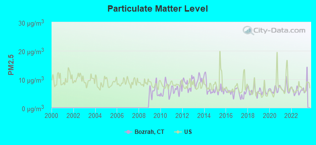
Particulate Matter (PM2.5) [µg/m3] level in 2022 was 5.88. This is better than average. Closest monitor was 5.6 miles away from the city center.
| City: | 5.88 |
| U.S.: | 8.11 |
Tornado activity:
Bozrah-area historical tornado activity is slightly below Connecticut state average. It is 40% smaller than the overall U.S. average.
On 10/3/1979, a category F4 (max. wind speeds 207-260 mph) tornado 34.1 miles away from the Bozrah town center killed 3 people and injured 500 people and caused between $50,000,000 and $500,000,000 in damages.
On 8/21/1951, a category F3 (max. wind speeds 158-206 mph) tornado 16.7 miles away from the town center injured 8 people and caused between $50,000 and $500,000 in damages.
Earthquake activity:
Bozrah-area historical earthquake activity is significantly above Connecticut state average. It is 72% smaller than the overall U.S. average.On 10/7/1983 at 10:18:46, a magnitude 5.3 (5.1 MB, 5.3 LG, 5.1 ML, Class: Moderate, Intensity: VI - VII) earthquake occurred 199.3 miles away from the city center
On 4/20/2002 at 10:50:47, a magnitude 5.3 (5.3 ML, Depth: 3.0 mi) earthquake occurred 218.9 miles away from Bozrah center
On 4/20/2002 at 10:50:47, a magnitude 5.2 (5.2 MB, 4.2 MS, 5.2 MW, 5.0 MW) earthquake occurred 217.6 miles away from the city center
On 1/19/1982 at 00:14:42, a magnitude 4.7 (4.5 MB, 4.7 MD, 4.5 LG, Class: Light, Intensity: IV - V) earthquake occurred 138.2 miles away from the city center
On 10/16/2012 at 23:12:25, a magnitude 4.7 (4.7 ML, Depth: 10.0 mi) earthquake occurred 161.6 miles away from Bozrah center
On 8/22/1992 at 12:20:32, a magnitude 4.8 (4.8 MB, 3.8 MS, 4.7 LG, Depth: 6.2 mi) earthquake occurred 195.4 miles away from the city center
Magnitude types: regional Lg-wave magnitude (LG), body-wave magnitude (MB), duration magnitude (MD), local magnitude (ML), surface-wave magnitude (MS), moment magnitude (MW)
Natural disasters:
The number of natural disasters in New London County (22) is greater than the US average (15).Major Disasters (Presidential) Declared: 12
Emergencies Declared: 10
Causes of natural disasters: Hurricanes: 6, Snowstorms: 5, Storms: 5, Floods: 4, Blizzards: 3, Winter Storms: 3, Snows: 2, Snowfall: 1, Tropical Storm: 1, Wind: 1 (Note: some incidents may be assigned to more than one category).
Hospitals and medical centers near Bozrah:
- BACKUS HOME HEALTH CARE (Home Health Center, about 4 miles away; NORWICH, CT)
- INTERIM HEALTH CARE OF EASTERN (Home Health Center, about 4 miles away; NORWICH, CT)
- NORWICHTOWN REHABILITATION AND C (Nursing Home, about 4 miles away; NORWICH, CT)
- NORWICH DIALYSIS (Dialysis Facility, about 5 miles away; NORWICH, CT)
- UNITED COMM SVCS INC PHN DEPT-HOSPICE (Hospital, about 5 miles away; NORWICH, CT)
- WILLIAM W BACKUS HOSPITAL Acute Care Hospitals (about 5 miles away; NORWICH, CT)
- HOSPICE OF SOUTHEASTERN CT INC (Home Health Center, about 5 miles away; NORWICH, CT)
Airports located in Bozrah:
- Gager Field Airport (CT36) (Runways: 1)
Amtrak stations near Bozrah:
- 13 miles: FOXWOOD CASINO (LEDYARD, ROUTE 2) - Bus Station
- 15 miles: NEW LONDON (27 WATER ST.) . Services: ticket office, partially wheelchair accessible, enclosed waiting area, public restrooms, public payphones, paid short-term parking, paid long-term parking, call for car rental service, taxi stand, intercity bus service, public transit connection.
- 18 miles: MYSTIC (RTE. 1) . Services: enclosed waiting area, public restrooms, public payphones, free short-term parking, call for car rental service, call for taxi service, public transit connection.
Operable nuclear power plants near Bozrah:
- 14 miles: Millstone 1 and 2 in Waterford, CT.
- 14 miles: Millstone 3 in Waterford, CT.
Colleges/universities with over 2000 students nearest to Bozrah:
- Three Rivers Community College (about 5 miles; Norwich, CT; Full-time enrollment: 2,897)
- Eastern Connecticut State University (about 13 miles; Willimantic, CT; FT enrollment: 4,985)
- Connecticut College (about 13 miles; New London, CT; FT enrollment: 2,068)
- University of Connecticut (about 19 miles; Storrs, CT; FT enrollment: 22,037)
- Manchester Community College (about 25 miles; Manchester, CT; FT enrollment: 4,667)
- Wesleyan University (about 25 miles; Middletown, CT; FT enrollment: 3,517)
- Goodwin College (about 28 miles; East Hartford, CT; FT enrollment: 3,017)
Public elementary/middle school in Bozrah:
- FIELDS MEMORIAL SCHOOL (Students: 277, Location: 8 BOZRAH STREET EXTENSION B, Grades: PK-8)
Points of interest:
Notable locations in Bozrah: Camp Tadma (A), Camp Odetah (B), Bozrah Street (C), Bozrah Volunteer Fire Company Station 26 (D), Bozrah Town Hall (E). Display/hide their locations on the map
Churches in Bozrah include: Bozrah Center Congregational Church (A), Fitchville Baptist Church (B), Leffingwell Baptist Church (C). Display/hide their locations on the map
Cemeteries: Parker Cemetery (1), Gardner Bulkeley Cemetery (2), Scott Hill Cemetery (3), Bozrah Cemetery (4), Gardner Cemetery (5), Johnson Cemetery (6). Display/hide their locations on the map
Lakes, reservoirs, and swamps: Tadma Pond (A), Bishop Pond (B), Gilman Pond (C), Lake Marie (D), Fitchville Pond (E), Dark Swamp (F). Display/hide their locations on the map
Streams, rivers, and creeks: Mineral Spring Brook (A), Pearson Brook (B), Pease Brook (C), Austin Brook (D), Driscoll Brook (E), Gardner Brook (F), Kahn Brook (G). Display/hide their locations on the map
Park in Bozrah: Hopemead State Park (1). Display/hide its location on the map
Birthplace of: Reuben H. Walworth - Politician.
| This town: | 2.6 people |
| Connecticut: | 2.5 people |
| This town: | 72.0% |
| Whole state: | 66.3% |
| This town: | 6.0% |
| Whole state: | 6.6% |
Likely homosexual households (counted as self-reported same-sex unmarried-partner households)
- Lesbian couples: 0.3% of all households
- Gay men: 0.4% of all households
| This town: | 3.7% |
| Whole state: | 7.9% |
| This town: | 1.5% |
| Whole state: | 3.9% |
6 people in residential treatment centers for adults in 2010
24 people in nursing homes in 2000
6 people in homes for the mentally retarded in 2000
For population 15 years and over in Bozrah:
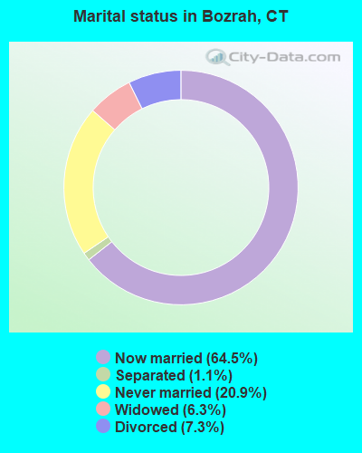
- Never married: 20.9%
- Now married: 64.5%
- Separated: 1.1%
- Widowed: 6.3%
- Divorced: 7.3%
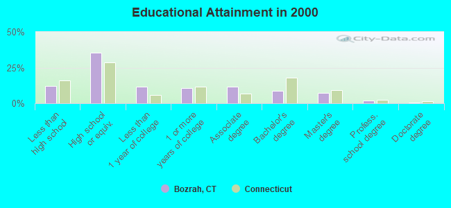
For population 25 years and over in Bozrah:
- High school or higher: 87.8%
- Bachelor's degree or higher: 18.7%
- Graduate or professional degree: 9.9%
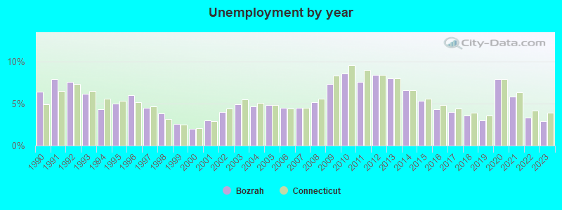
- Unemployed: 2.6%
- Mean travel time to work (commute): 25.6 minutes
| Here: | 10.7 |
| Connecticut average: | 12.8 |
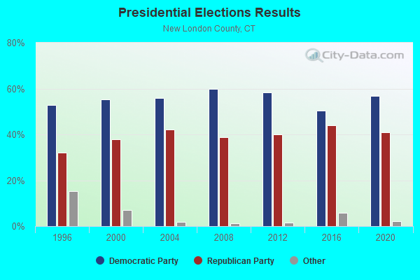
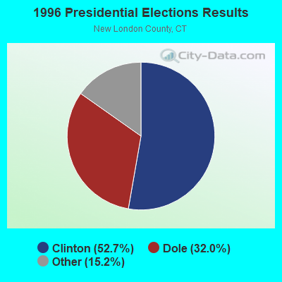
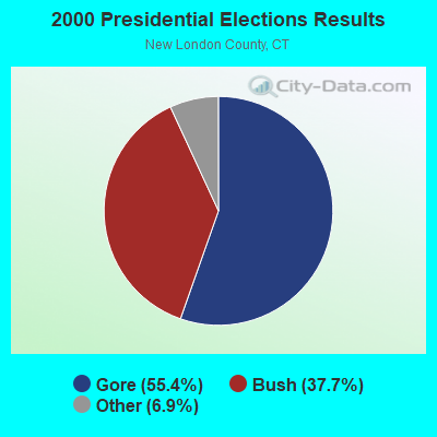

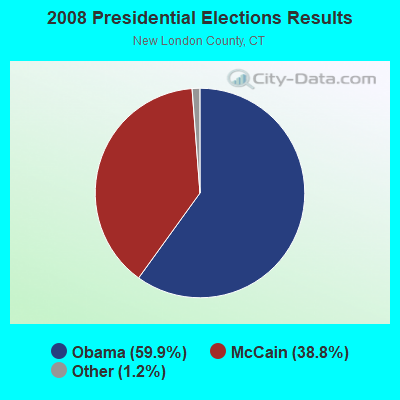

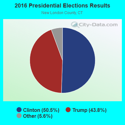
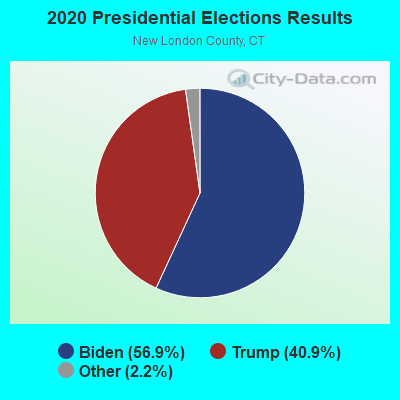
Graphs represent county-level data. Detailed 2008 Election Results
Religion statistics for Bozrah, CT (based on New London County data)
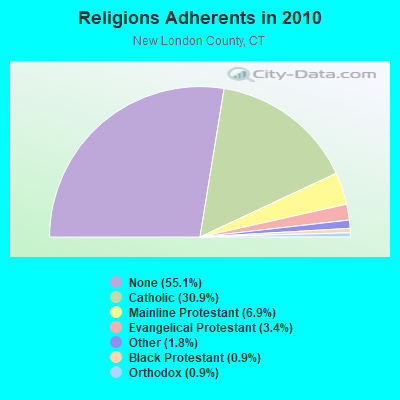
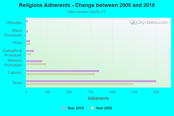
| Religion | Adherents | Congregations |
|---|---|---|
| Catholic | 84,765 | 34 |
| Mainline Protestant | 18,993 | 79 |
| Evangelical Protestant | 9,320 | 75 |
| Other | 5,022 | 32 |
| Black Protestant | 2,594 | 10 |
| Orthodox | 2,456 | 4 |
| None | 150,905 | - |
Food Environment Statistics:
| New London County: | 1.82 / 10,000 pop. |
| Connecticut: | 2.21 / 10,000 pop. |
| This county: | 0.11 / 10,000 pop. |
| State: | 0.07 / 10,000 pop. |
| New London County: | 1.36 / 10,000 pop. |
| Connecticut: | 1.02 / 10,000 pop. |
| New London County: | 3.22 / 10,000 pop. |
| State: | 2.27 / 10,000 pop. |
| Here: | 10.01 / 10,000 pop. |
| State: | 9.19 / 10,000 pop. |
| This county: | 7.6% |
| Connecticut: | 7.3% |
| New London County: | 22.4% |
| Connecticut: | 21.5% |
| This county: | 16.5% |
| State: | 15.8% |
6.16% of this county's 2021 resident taxpayers lived in other counties in 2020 ($81,025 average adjusted gross income)
| Here: | 6.16% |
| Connecticut average: | 5.79% |
0.04% of residents moved from foreign countries ($359 average AGI)
New London County: 0.04% Connecticut average: 0.02%
Top counties from which taxpayers relocated into this county between 2020 and 2021:
| from Hartford County, CT | |
| from Windham County, CT | |
| from Middlesex County, CT |
6.02% of this county's 2020 resident taxpayers moved to other counties in 2021 ($71,482 average adjusted gross income)
| Here: | 6.02% |
| Connecticut average: | 5.82% |
0.05% of residents moved to foreign countries ($502 average AGI)
New London County: 0.05% Connecticut average: 0.02%
Top counties to which taxpayers relocated from this county between 2020 and 2021:
| to Hartford County, CT | |
| to Windham County, CT | |
| to Middlesex County, CT |
Businesses in Bozrah, CT
- UPS: 2
Strongest AM radio stations in Bozrah:
- WICH (1310 AM; 5 kW; NORWICH, CT; Owner: WICH, INCORPORATED)
- WTIC (1080 AM; 50 kW; HARTFORD, CT; Owner: INFINITY RADIO OPERATIONS INC.)
- WALE (990 AM; 50 kW; GREENVILLE, RI; Owner: NORTH AMERICAN BROADCASTING CO., INC.)
- WNNZ (640 AM; 50 kW; WESTFIELD, MA; Owner: CLEAR CHANNEL BROADCASTING LICENSES, INC.)
- WCRN (830 AM; 50 kW; WORCESTER, MA; Owner: CARTER BROADCASTING CORPORATION)
- WVNE (760 AM; daytime; 25 kW; LEICESTER, MA; Owner: BLOUNT MASSCOM, INC.)
- WEEI (850 AM; 50 kW; BOSTON, MA; Owner: ENTERCOM BOSTON LICENSE, LLC)
- WRKO (680 AM; 50 kW; BOSTON, MA; Owner: ENTERCOM BOSTON LICENSE, LLC)
- WKOX (1200 AM; 50 kW; FRAMINGHAM, MA; Owner: CAPSTAR TX LIMITED PARTNERSHIP)
- WLIS (1420 AM; 5 kW; OLD SAYBROOK, CT; Owner: CROSSROADS COMM. OLD SAYBROOK, LLC)
- WBIX (1060 AM; 40 kW; NATICK, MA; Owner: LANGER BROADCASTING CORPORATION)
- WFAN (660 AM; 50 kW; NEW YORK, NY; Owner: INFINITY BROADCASTING OPERATIONS, INC.)
- WAMG (890 AM; 25 kW; DEDHAM, MA; Owner: MEGA COMMUNICATIONS OF DEDHAM LICENSEE, LLC)
Strongest FM radio stations in Bozrah:
- WCTY (97.7 FM; NORWICH, CT; Owner: WICH, INC.)
- WILI-FM (98.3 FM; WILLIMANTIC, CT; Owner: NUTMEG BROADCASTING COMPANY)
- WKNL (100.9 FM; NEW LONDON, CT; Owner: HALL COMMUNICATIONS, INC.)
- WBMW (106.5 FM; LEDYARD, CT; Owner: RED WOLF BROADCASTING CORPORATION)
- WECS (90.1 FM; WILLIMANTIC, CT; Owner: EASTERN CONNECTICUT STATE COLLEGE)
- WHJM (107.7 FM; PAWCATUCK, CT; Owner: FULLER BROADCASTING INTERNATIONAL, LLC)
- WNPR (89.1 FM; NORWICH, CT; Owner: CONNECTICUT PUBLIC B/NG, INC.)
- WRCH (100.5 FM; NEW BRITAIN, CT; Owner: INFINITY RADIO OPERATIONS INC.)
- WHUS (91.7 FM; STORRS, CT; Owner: THE BD. OF TRUSTEES, THE UNIV. OF CT)
- WWRX-FM (103.7 FM; WESTERLY, RI; Owner: FNX BROADCASTING OF RHODE ISLAND, LLC)
- WQGN-FM (105.5 FM; GROTON, CT; Owner: CITADEL BROADCASTING COMPANY)
- WNLC (98.7 FM; EAST LYME, CT; Owner: HALL COMMUNICATIONS, INC.)
- WKSS (95.7 FM; HARTFORD-MERIDEN, CT; Owner: CAPSTAR TX LIMITED PARTNERSHIP)
- WWYZ (92.5 FM; WATERBURY, CT; Owner: CAPSTAR TX LIMITED PARTNERSHIP)
- WZMX (93.7 FM; HARTFORD, CT; Owner: INFINITY RADIO OPERATIONS INC.)
- WHCN (105.9 FM; HARTFORD, CT; Owner: CAPSTAR TX LIMITED PARTNERSHIP)
- WKCI-FM (101.3 FM; HAMDEN, CT; Owner: CLEAR CHANNEL BROADCASTING LICENSES, INC.)
- WMRQ (104.1 FM; WATERBURY, CT; Owner: CAPSTAR TX LIMITED PARTNERSHIP)
- WPKT (90.5 FM; MERIDEN, CT; Owner: CONNECTICUT PUBLIC BROADCASTING, INC)
- WDRC-FM (102.9 FM; HARTFORD, CT; Owner: BUCKLEY BROADCASTING CORPORATION)
TV broadcast stations around Bozrah:
- WEDN (Channel 53; NORWICH, CT; Owner: CONNECTICUT PUBLIC BROADCASTING, INC.)
- WHPX (Channel 26; NEW LONDON, CT; Owner: PAXSON HARTFORD LICENSE, INC.)
- WPXQ (Channel 69; BLOCK ISLAND, RI; Owner: OCEAN STATE TELEVISION, L.L.C.)
- WTIC-TV (Channel 61; HARTFORD, CT; Owner: TRIBUNE TELEVISION COMPANY)
- W11BJ (Channel 11; HARTFORD, CT; Owner: COMMUNICATIONS SITE MANAGEMENT LLC)
- WTXX (Channel 20; WATERBURY, CT; Owner: WTXX INC.)
- WVIT (Channel 30; NEW BRITAIN, CT; Owner: OUTLET BROADCASTING, INC)
- WUVN (Channel 18; HARTFORD, CT; Owner: ENTRAVISION HOLDINGS, LLC)
- WEDH (Channel 24; HARTFORD, CT; Owner: CONNECTICUT PUBLIC BROADCASTING, INC.)
- WYDN (Channel 48; WORCESTER, MA; Owner: EDUCATIONAL PUBLIC TV CORPORATION)
- WTNH (Channel 8; NEW HAVEN, CT; Owner: WTNH BROADCASTING, INC.)
- National Bridge Inventory (NBI) Statistics
- 22Number of bridges
- 210ft / 64.1mTotal length
- 159,288Total average daily traffic
- 8,815Total average daily truck traffic
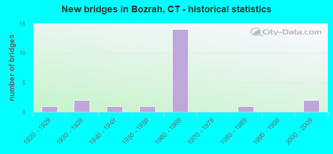
- New bridges - historical statistics
- 11920-1929
- 21930-1939
- 11940-1949
- 11950-1959
- 141960-1969
- 11980-1989
- 22000-2009
FCC Registered Cell Phone Towers:
1 (See the full list of FCC Registered Cell Phone Towers in Bozrah)FCC Registered Antenna Towers:
7 (See the full list of FCC Registered Antenna Towers)FCC Registered Broadcast Land Mobile Towers:
4- Scott Hill Rd 1 Mi W Of Rt 163 (Lat: 41.542333 Lon: -72.209806), Call Sign: KKW515,
Assigned Frequencies: 35.3200 MHz, Grant Date: 05/13/1997, Expiration Date: 05/13/2002, Cancellation Date: 09/15/2002, Registrant: Connecticut Carting Corp, Bozrah, CT 06334, Phone: (203) 889-3394
- Lat: 41.573056 Lon: -72.141389, Call Sign: WQUR356,
Assigned Frequencies: 451.712 MHz, 456.712 MHz, Grant Date: 09/17/2014, Expiration Date: 09/17/2024, Certifier: Christopher R Jewell, Registrant: Connecticut Radio, Inc., 1208 Cromwell Ave, Rocky Hill, CT 06067, Phone: (860) 563-4867, Fax: (860) 563-1179, Email:
- 380 Salem Turnpike (Lat: 41.506000 Lon: -72.139972), Call Sign: WRDL668,
Assigned Frequencies: 456.412 MHz, 456.662 MHz, 457.037 MHz, 457.987 MHz, Grant Date: 05/29/2019, Expiration Date: 05/29/2029, Certifier: Chad Sisco, Registrant: National License, 12591 Brompton Road, Carmel, IN 46033, Phone: (317) 564-8018, Email:
- Lat: 41.565444 Lon: -72.151361, Call Sign: WRYH741,
Assigned Frequencies: 451.412 MHz, 452.312 MHz, 456.412 MHz, 457.312 MHz, 457.687 MHz, Grant Date: 08/11/2023, Expiration Date: 08/11/2033, Certifier: Keegan D Kelley, Registrant: United Parcel Service, Inc., 2200 Outer Loop, Louisville, KY 40219-3565, Phone: (502) 961-1406, Fax: (502) 961-4141, Email:
FCC Registered Microwave Towers:
2- Bishop Rd 3.2 Mi S Of Fitchville (Lat: 41.520639 Lon: -72.167000), Overall height: 145.4 m, Call Sign: WPOT890,
Assigned Frequencies: 947.500 MHz, Grant Date: 06/16/1999, Expiration Date: 06/01/2030, Registrant: Lerman Senter Pllc, 2001 L Street, Nw Suite 400, Washington, DC 20036, Phone: (202) 416-6744, Email:
- Norwich, Bishop Road, 3.2 Miles South Of Fitchville, Ct (Lat: 41.520556 Lon: -72.166944), Type: Tower, Structure height: 137.1 m, Overall height: 145.3 m, Call Sign: WQGC681,
Assigned Frequencies: 6900.00 MHz, Grant Date: 12/11/2006, Expiration Date: 04/01/2031, Certifier: Meg Sakellarides, Registrant: Lerman Senter Pllc, 2001 L Street, Nw Suite 400, Washington, DC 20036, Phone: (202) 416-6744, Email:
FCC Registered Amateur Radio Licenses:
27 (See the full list of FCC Registered Amateur Radio Licenses in Bozrah)FAA Registered Aircraft:
1- Aircraft: BEECH B19 (Category: Land, Seats: 4, Weight: Up to 12,499 Pounds, Speed: 116 mph), Engine: LYCOMING 0-320 SERIES (180 HP) (Reciprocating)
N-Number: 24597, N24597, N-24597, Serial Number: MB-549, Year manufactured: 1972, Airworthiness Date: 09/06/1972, Certificate Issue Date: 08/14/2002
Registrant (Individual): George Iii Pillar, 32 Lake Rd, Bozrah, CT 06334
2002 - 2018 National Fire Incident Reporting System (NFIRS) incidents
- Fire incident types reported to NFIRS in Bozrah, CT
- 11751.8%Structure Fires
- 5624.8%Outside Fires
- 3515.5%Mobile Property/Vehicle Fires
- 188.0%Other
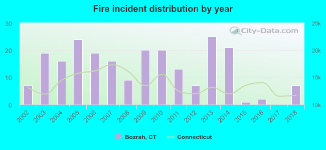 According to the data from the years 2002 - 2018 the average number of fires per year is 13. The highest number of reported fire incidents - 25 took place in 2013, and the least - 0 in 2017. The data has a constant trend.
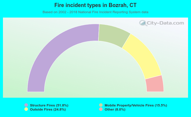 When looking into fire subcategories, the most incidents belonged to: Structure Fires (51.8%), and Outside Fires (24.8%).
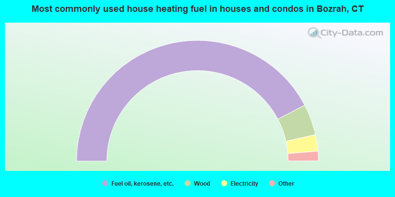
- 84.7%Fuel oil, kerosene, etc.
- 8.3%Wood
- 4.4%Electricity
- 1.2%Utility gas
- 0.6%Bottled, tank, or LP gas
- 0.4%Solar energy
- 0.4%Other fuel
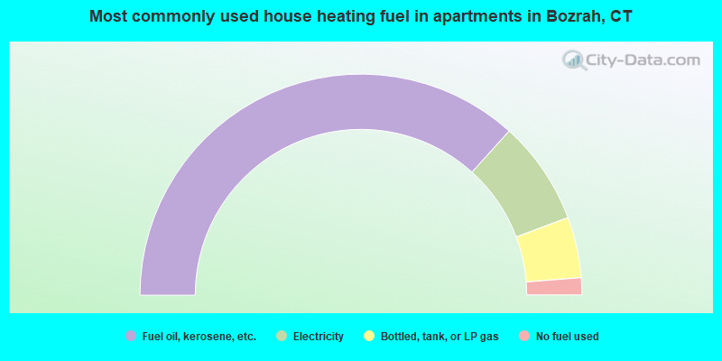
- 73.4%Fuel oil, kerosene, etc.
- 15.2%Electricity
- 8.9%Bottled, tank, or LP gas
- 2.5%No fuel used
Bozrah compared to Connecticut state average:
- Unemployed percentage significantly below state average.
- Black race population percentage significantly below state average.
- Hispanic race population percentage significantly below state average.
- Median age above state average.
- Foreign-born population percentage significantly below state average.
- Renting percentage below state average.
- Length of stay since moving in significantly above state average.
- Number of rooms per house significantly below state average.
- House age significantly below state average.
- Percentage of population with a bachelor's degree or higher below state average.

|
|
Total of 58 patent applications in 2008-2024.