Bridge Statistics for Bradford, Pennsylvania (PA)
Condition, Traffic, Stress, Structural Evaluation, Project Costs
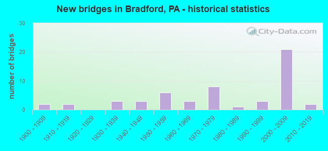
- New bridges - historical statistics
- 21900-1909
- 21910-1919
- 31930-1939
- 31940-1949
- 61950-1959
- 31960-1969
- 81970-1979
- 11980-1989
- 31990-1999
- 212000-2009
- 22010-2019
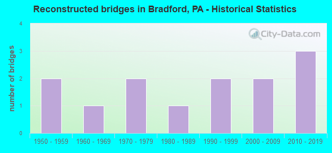
- Reconstructed bridges - Historical Statistics
- 21950-1959
- 11960-1969
- 21970-1979
- 11980-1989
- 21990-1999
- 22000-2009
- 32010-2019
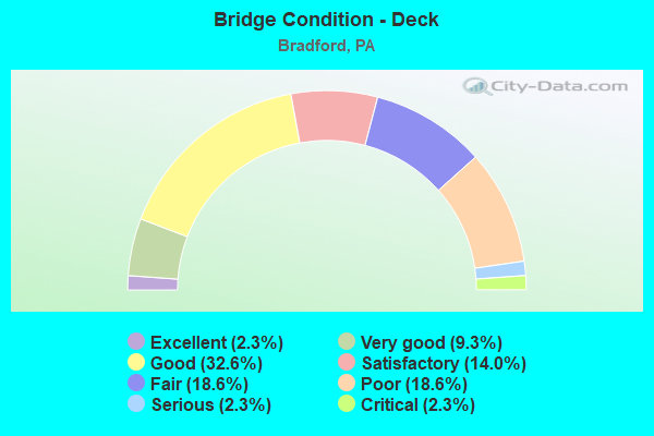
- Bridge Condition - Deck
- 2.3%Excellent
- 9.3%Very good
- 32.6%Good
- 14.0%Satisfactory
- 18.6%Fair
- 18.6%Poor
- 2.3%Serious
- 2.3%Critical
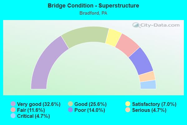
- Bridge Condition - Superstructure
- 32.6%Very good
- 25.6%Good
- 7.0%Satisfactory
- 11.6%Fair
- 14.0%Poor
- 4.7%Serious
- 4.7%Critical
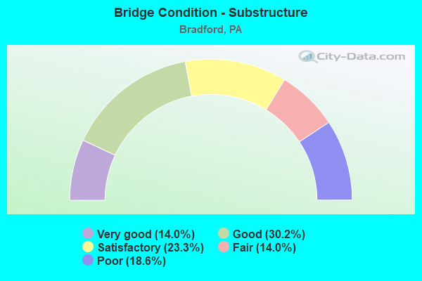
- Bridge Condition - Substructure
- 14.0%Very good
- 30.2%Good
- 23.3%Satisfactory
- 14.0%Fair
- 18.6%Poor
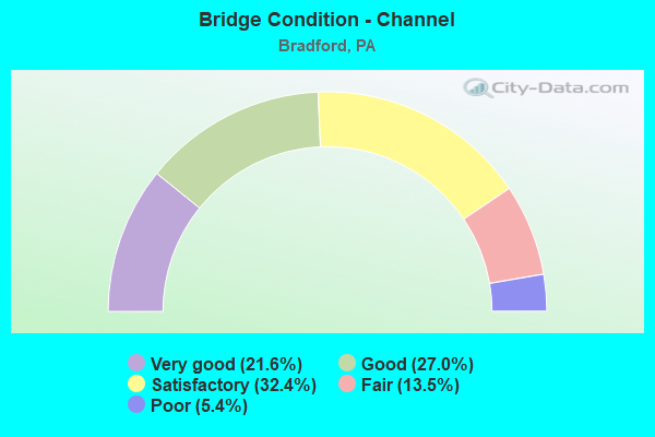
- Bridge Condition - Channel
- 21.6%Very good
- 27.0%Good
- 32.4%Satisfactory
- 13.5%Fair
- 5.4%Poor
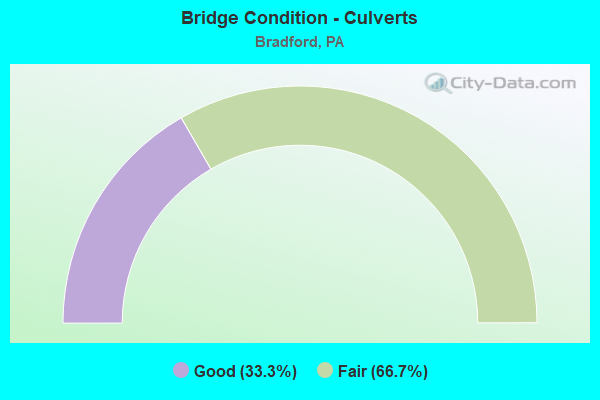
- Bridge Condition - Culverts
- 33.3%Good
- 66.7%Fair
Find on map >> Show street view
Structure Number: 4413, Location: OVER KENDALL AVE (Lat: 41.968925, Lng: -78.629619), Route carried "on" structure: US 219, Year Built: 2006, Status: Open, Structure Length: 3.75m (12.30ft), Average Daily Traffic: 3,845 (year 2022), Truck Traffic: 12%, Average Future Daily Traffic: 6,158 (year 2040), Design Load: HL 93, Features Intersected: SR 4013 (PA 46)
Minimum Vertical Clearance: 30+ m (98+ ft), Kilometerpoint: 43.111, Lanes on structure: 2, Lanes under structure: 4, Base Highway Network: Yes, Owner: State Highway Agency, Approaching Roadway Width: 14.0m (45.9ft), Skew: 33 degrees, Material/Design: Prestressed concrete, Design/Construction: Stringer/Multi-beam, Number Of Spans In Main Unit: 1, Length of Maximum Span: 36.6m (120.1ft), Curb or Sidewalk Widths: Left: 0.1m (0.3ft), Right: 0.1m (0.3ft), Curb-To-Curb Width: 14.0m (45.9ft), Out-to-Out Width: 15.0m (49.2ft)
Condition: Deck: Good, Superstructure: Good, Substructure: Good, Operating Rating: 77.1 metric tons, Method Used To Determine Operating Rating: Load Factor (LF), Inventory Rating: 46.3 metric tons, Method Used To Determine Inventory Rating: Load Factor (LF), Structural Evaluation: Better than present minimum criteria, Deck Geometry: Superior to present desirable criteria, Underclear: Somewhat better than minimum adequacy, Approach Roadway Alignment: Equal to present desirable criteria, Designated Inspection Frequency: Every 24 months, Inspection Date: June 2020, Deck Structure Type: Concrete Cast-file-Place, Wearing Surface/Protective System: Wearing Surface: Monolithic Concrete, Deck Protection: Epoxy Coated Reinforcing
Find on map >> Show street view
Structure Number: 44146, Location: CITY OF BRADFORD (Lat: 41.963678, Lng: -78.639067), Route carried "on" structure: US 219, Year Built: 2006, Status: Open, Structure Length: 18.23m (59.81ft), Average Daily Traffic: 7,192 (year 2021), Truck Traffic: 10%, Average Future Daily Traffic: 7,097 (year 2040), Design Load: HS 25 or greater, Features Intersected: MILL ST - B&P RAILROAD
Minimum Vertical Clearance: 30+ m (98+ ft), Kilometerpoint: 42.041, Lanes on structure: 2, Lanes under structure: 2, Base Highway Network: Yes, Owner: State Highway Agency, Approaching Roadway Width: 10.4m (34.1ft), Skew: 10 degrees, Material/Design: Steel continuous, Design/Construction: Stringer/Multi-beam, Number Of Spans In Main Unit: 4, Length of Maximum Span: 51.8m (169.9ft), Curb or Sidewalk Widths: Left: 0.2m (0.7ft), Right: 0.2m (0.7ft), Curb-To-Curb Width: 10.4m (34.1ft), Out-to-Out Width: 11.4m (37.4ft)
Condition: Deck: Good, Superstructure: Very good, Substructure: Very good, Operating Rating: 43.5 metric tons, Method Used To Determine Operating Rating: Load Factor (LF), Inventory Rating: 25.4 metric tons, Method Used To Determine Inventory Rating: Load Factor (LF), Structural Evaluation: Equal to present minimum criteria, Deck Geometry: Meets minimum limits, Underclear: Equal to present minimum criteria, Approach Roadway Alignment: Equal to present minimum criteria, Designated Inspection Frequency: Every 24 months, Inspection Date: June 2020, Deck Structure Type: Concrete Cast-file-Place, Wearing Surface/Protective System: Wearing Surface: Epoxy Overlay, Deck Protection: Epoxy Coated Reinforcing
Find on map >> Show street view
Structure Number: 44156, Location: BRADFORD BYPASS (Lat: 41.930878, Lng: -78.648639), Route carried "on" structure: US 219, Year Built: 2007, Status: Open, Structure Length: 1.92m (6.30ft), Average Daily Traffic: 3,845 (year 2022), Truck Traffic: 12%, Average Future Daily Traffic: 6,158 (year 2040), Design Load: HL 93, Features Intersected: BOLIVAR RUN
Minimum Vertical Clearance: 30+ m (98+ ft), Kilometerpoint: 43.111, Lanes on structure: 3, Base Highway Network: Yes, Owner: State Highway Agency, Approaching Roadway Width: 14.6m (47.9ft), Skew: 10 degrees, Material/Design: Prestressed concrete, Design/Construction: Box Beam or Girders - Single/Spread, Number Of Spans In Main Unit: 1, Length of Maximum Span: 18.3m (60.0ft), Curb-To-Curb Width: 14.6m (47.9ft), Out-to-Out Width: 15.7m (51.5ft)
Condition: Deck: Good, Superstructure: Very good, Substructure: Good, Channel: Very good, Operating Rating: 63.5 metric tons, Method Used To Determine Operating Rating: Load Factor (LF), Inventory Rating: 38.1 metric tons, Method Used To Determine Inventory Rating: Load Factor (LF), Structural Evaluation: Better than present minimum criteria, Deck Geometry: Meets minimum limits, Waterway Adequacy: Better than present minimum criteria, Approach Roadway Alignment: Equal to present desirable criteria, Designated Inspection Frequency: Every 24 months, Inspection Date: June 2020, Deck Structure Type: Concrete Cast-file-Place, Wearing Surface/Protective System: Wearing Surface: Monolithic Concrete, Deck Protection: Epoxy Coated Reinforcing
Find on map >> Show street view
Structure Number: 44169, Location: CITY OF BRADFORD (Lat: 41.953039, Lng: -78.645864), Route carried "on" structure: US 219, Year Built: 2008, Status: Open, Structure Length: 2.96m (9.71ft), Average Daily Traffic: 3,297 (year 2021), Truck Traffic: 14%, Average Future Daily Traffic: 3,977 (year 2040), Design Load: HL 93, Features Intersected: SR 4015 (ELM STREET)
Minimum Vertical Clearance: 30+ m (98+ ft), Kilometerpoint: 40.782, Lanes on structure: 2, Lanes under structure: 2, Base Highway Network: Yes, Owner: State Highway Agency, Approaching Roadway Width: 10.4m (34.1ft), Skew: 11 degrees, Material/Design: Steel, Design/Construction: Stringer/Multi-beam, Number Of Spans In Main Unit: 1, Length of Maximum Span: 29.0m (95.1ft), Curb or Sidewalk Widths: Left: 1.5m (4.9ft), Right: 1.5m (4.9ft), Curb-To-Curb Width: 10.4m (34.1ft), Out-to-Out Width: 11.4m (37.4ft)
Condition: Deck: Good, Superstructure: Very good, Substructure: Very good, Operating Rating: 61.7 metric tons, Method Used To Determine Operating Rating: Load Factor (LF), Inventory Rating: 37.2 metric tons, Method Used To Determine Inventory Rating: Load Factor (LF), Structural Evaluation: Equal to present desirable criteria, Deck Geometry: Meets minimum limits, Underclear: Meets minimum limits, Approach Roadway Alignment: Equal to present desirable criteria, Designated Inspection Frequency: Every 24 months, Inspection Date: July 2020, Deck Structure Type: Concrete Cast-file-Place, Wearing Surface/Protective System: Wearing Surface: Monolithic Concrete, Deck Protection: Epoxy Coated Reinforcing
Find on map >> Show street view
Structure Number: 44352, Location: BRADFORD BYPASS (Lat: 41.625056, Lng: -78.676094), Route carried "on" structure: US 219, Year Built: 2007, Status: Open, Structure Length: 1.89m (6.20ft), Average Daily Traffic: 4,539 (year 2022), Truck Traffic: 10%, Average Future Daily Traffic: 7,095 (year 2040), Design Load: HL 93, Features Intersected: BOLIVAR RUN
Minimum Vertical Clearance: 30+ m (98+ ft), Kilometerpoint: 43.084, Lanes on structure: 3, Base Highway Network: Yes, Owner: State Highway Agency, Approaching Roadway Width: 14.0m (45.9ft), Skew: 10 degrees, Material/Design: Prestressed concrete, Design/Construction: Box Beam or Girders - Single/Spread, Number Of Spans In Main Unit: 1, Length of Maximum Span: 18.3m (60.0ft), Curb or Sidewalk Widths: Left: 0.1m (0.3ft), Right: 0.1m (0.3ft), Curb-To-Curb Width: 14.0m (45.9ft), Out-to-Out Width: 15.1m (49.5ft)
Condition: Deck: Good, Superstructure: Very good, Substructure: Good, Channel: Very good, Operating Rating: 63.5 metric tons, Method Used To Determine Operating Rating: Load Factor (LF), Inventory Rating: 38.1 metric tons, Method Used To Determine Inventory Rating: Load Factor (LF), Structural Evaluation: Better than present minimum criteria, Deck Geometry: Meets minimum limits, Waterway Adequacy: Equal to present desirable criteria, Approach Roadway Alignment: Equal to present desirable criteria, Designated Inspection Frequency: Every 24 months, Inspection Date: June 2020, Deck Structure Type: Concrete Cast-file-Place, Wearing Surface/Protective System: Wearing Surface: Monolithic Concrete, Deck Protection: Epoxy Coated Reinforcing
Find on map >> Show street view
Structure Number: 44353, Location: OVER KENDALL AVE (Lat: 41.968725, Lng: -78.629578), Route carried "on" structure: US 219, Year Built: 2007, Status: Open, Structure Length: 3.78m (12.40ft), Average Daily Traffic: 4,539 (year 2022), Truck Traffic: 10%, Average Future Daily Traffic: 7,095 (year 2040), Design Load: HL 93, Features Intersected: SR 4013 (PA 46)
Minimum Vertical Clearance: 30+ m (98+ ft), Kilometerpoint: 43.084, Lanes on structure: 2, Lanes under structure: 4, Base Highway Network: Yes, Owner: State Highway Agency, Approaching Roadway Width: 9.8m (32.2ft), Skew: 33 degrees, Material/Design: Prestressed concrete, Design/Construction: Stringer/Multi-beam, Number Of Spans In Main Unit: 1, Length of Maximum Span: 36.6m (120.1ft), Curb or Sidewalk Widths: Left: 0.1m (0.3ft), Right: 0.1m (0.3ft), Curb-To-Curb Width: 10.4m (34.1ft), Out-to-Out Width: 11.4m (37.4ft)
Condition: Deck: Good, Superstructure: Good, Substructure: Good, Operating Rating: 76.2 metric tons, Method Used To Determine Operating Rating: Load Factor (LF), Inventory Rating: 45.4 metric tons, Method Used To Determine Inventory Rating: Load Factor (LF), Structural Evaluation: Better than present minimum criteria, Deck Geometry: Meets minimum limits, Underclear: Equal to present minimum criteria, Approach Roadway Alignment: Equal to present desirable criteria, Designated Inspection Frequency: Every 24 months, Inspection Date: June 2020, Deck Structure Type: Concrete Cast-file-Place, Wearing Surface/Protective System: Wearing Surface: Monolithic Concrete, Deck Protection: Epoxy Coated Reinforcing
Find on map >> Show street view
Structure Number: 44354, Location: CITY OF BRADFORD (Lat: 41.963606, Lng: -78.638944), Route carried "on" structure: US 219, Year Built: 2007, Status: Open, Structure Length: 18.32m (60.10ft), Average Daily Traffic: 6,119 (year 2021), Truck Traffic: 11%, Average Future Daily Traffic: 8,422 (year 2040), Design Load: HS 25 or greater, Features Intersected: MILL ST - B&P RAILROAD
Minimum Vertical Clearance: 30+ m (98+ ft), Kilometerpoint: 42.026, Lanes on structure: 2, Lanes under structure: 2, Base Highway Network: Yes, Owner: State Highway Agency, Approaching Roadway Width: 10.4m (34.1ft), Skew: 10 degrees, Material/Design: Steel continuous, Design/Construction: Stringer/Multi-beam, Number Of Spans In Main Unit: 4, Length of Maximum Span: 54.9m (180.1ft), Curb or Sidewalk Widths: Left: 0.2m (0.7ft), Right: 0.2m (0.7ft), Curb-To-Curb Width: 10.4m (34.1ft), Out-to-Out Width: 11.4m (37.4ft)
Condition: Deck: Very good, Superstructure: Very good, Substructure: Very good, Operating Rating: 43.5 metric tons, Method Used To Determine Operating Rating: Load Factor (LF), Inventory Rating: 22.7 metric tons, Method Used To Determine Inventory Rating: Load Factor (LF), Structural Evaluation: Somewhat better than minimum adequacy, Deck Geometry: Meets minimum limits, Underclear: Equal to present minimum criteria, Approach Roadway Alignment: Equal to present desirable criteria, Designated Inspection Frequency: Every 24 months, Inspection Date: July 2020, Deck Structure Type: Concrete Cast-file-Place, Wearing Surface/Protective System: Wearing Surface: Epoxy Overlay, Deck Protection: Epoxy Coated Reinforcing
Find on map >> Show street view
Structure Number: 53497, Location: 1200 FT SOUTH OF SR 346 (Lat: 41.941200, Lng: -78.680197), Route carried "on" structure: City street , Year Built: 2016, Status: Open, Structure Length: 1.62m (5.31ft), Average Daily Traffic: 400 (year 2018), Truck Traffic: 3%, Average Future Daily Traffic: 560 (year 2038), Design Load: HL 93, Features Intersected: MARILLA CREEK, Facility Carried by Structure: T-339 LANGMAID LN
Minimum Vertical Clearance: 30+ m (98+ ft), Kilometerpoint: 0.000, Lanes on structure: 2, Owner: Town or Township Highway Agency, Approaching Roadway Width: 5.2m (17.1ft), Skew: 1 degrees, Material/Design: Steel, Design/Construction: Stringer/Multi-beam, Number Of Spans In Main Unit: 1, Length of Maximum Span: 15.2m (49.9ft), Curb-To-Curb Width: 7.4m (24.3ft), Out-to-Out Width: 7.6m (24.9ft)
Condition: Deck: Excellent, Superstructure: Very good, Substructure: Very good, Channel: Satisfactory, Operating Rating: 70.8 metric tons, Method Used To Determine Operating Rating: Assigned rating based on Load Factor Design (LFD) reported in metric tons, Inventory Rating: 42.6 metric tons, Method Used To Determine Inventory Rating: Assigned rating based on Load Factor Design (LFD) reported in metric tons, Structural Evaluation: Equal to present desirable criteria, Deck Geometry: Somewhat better than minimum adequacy, Waterway Adequacy: Superior to present desirable criteria, Approach Roadway Alignment: Equal to present desirable criteria, Designated Inspection Frequency: Every 24 months, Inspection Date: August 2020, Deck Structure Type: Open Grating
Find on map >> Show street view
Structure Number: 56075, Location: AT SR 346 INTERSECTION (Lat: 41.947194, Lng: -78.706597), Route carried "on" structure: City street , Year Built: 2018, Status: Open, Structure Length: 1.46m (4.79ft), Average Daily Traffic: 75 (year 2018), Truck Traffic: 2%, Average Future Daily Traffic: 100 (year 2038), Design Load: HS 20, Features Intersected: MARILLA CREEK, Facility Carried by Structure: T594 SLEEPY HOLLOW
Minimum Vertical Clearance: 30+ m (98+ ft), Kilometerpoint: 0.000, Lanes on structure: 2, Owner: Town or Township Highway Agency, Approaching Roadway Width: 5.5m (18.0ft), Material/Design: Steel, Design/Construction: Stringer/Multi-beam, Number Of Spans In Main Unit: 1, Length of Maximum Span: 14.0m (45.9ft), Curb-To-Curb Width: 6.7m (22.0ft), Out-to-Out Width: 7.0m (23.0ft)
Condition: Deck: Very good, Superstructure: Very good, Substructure: Very good, Channel: Satisfactory, Operating Rating: 67.1 metric tons, Method Used To Determine Operating Rating: Assigned rating based on Load Factor Design (LFD) reported in metric tons, Inventory Rating: 39.9 metric tons, Method Used To Determine Inventory Rating: Assigned rating based on Load Factor Design (LFD) reported in metric tons, Structural Evaluation: Equal to present desirable criteria, Deck Geometry: Somewhat better than minimum adequacy, Waterway Adequacy: Equal to present desirable criteria, Approach Roadway Alignment: Equal to present desirable criteria, Designated Inspection Frequency: Every 24 months, Inspection Date: September 2020, Deck Structure Type: Wood or Timber, Wearing Surface/Protective System: Wearing Surface: Wood or Timber
Find on map >> Show street view
Structure Number: 25352, Location: BRADFORD (Lat: 41.976886, Lng: -78.625942), Route carried "under" structure: State highway , Year Built: 1977, Structure Length: 0. m, Average Daily Traffic: 5,123 (year 2022), Truck Traffic: 9%, Features Intersected: SR 346 AND SR 4013, Facility Carried by Structure: SR 219-US 219
Minimum Vertical Clearance: 5.11m (16.77ft), Kilometerpoint: 0.893, Lanes on structure: 6, Lanes under structure: 2, Material/Design: Steel, Design/Construction: Stringer/Multi-beam, Length of Maximum Span: 30.5m (100.1ft)
Find on map >> Show street view
Structure Number: 25352, Location: BRADFORD (Lat: 41.976886, Lng: -78.625942), Route carried "under" structure: State highway 346, Year Built: 1977, Structure Length: 0. m, Average Daily Traffic: 9,436 (year 2021), Truck Traffic: 4%, Features Intersected: SR 346 AND SR 4013, Facility Carried by Structure: SR 219-US 219
Minimum Vertical Clearance: 5.11m (16.77ft), Kilometerpoint: 25.790, Lanes on structure: 6, Lanes under structure: 2, Material/Design: Steel, Design/Construction: Stringer/Multi-beam, Length of Maximum Span: 30.5m (100.1ft)
Find on map >> Show street view
Structure Number: 43486, Location: CITY OF BRADFORD (Lat: 41.957900, Lng: -78.642686), Route carried "under" structure: City street , Year Built: 2007, Structure Length: 0. m, Average Daily Traffic: 2,798 (year 1996), Features Intersected: FORMAN ST & TUNUNGWANT C, Facility Carried by Structure: SR 219-US 219
Minimum Vertical Clearance: 4.93m (16.17ft), Kilometerpoint: 0.000, Lanes on structure: 2, Lanes under structure: 2, Material/Design: Steel continuous, Design/Construction: Stringer/Multi-beam, Length of Maximum Span: 35.7m (117.1ft)
Find on map >> Show street view
Structure Number: 43511, Location: CITY OF BRADFORD (Lat: 41.957583, Lng: -78.643356), Route carried "under" structure: City street , Year Built: 2006, Structure Length: 0. m, Average Daily Traffic: 2,798 (year 1996), Features Intersected: FORMAN ST & TUNUNGWANT C, Facility Carried by Structure: SR 219-US 219
Minimum Vertical Clearance: 4.64m (15.22ft), Kilometerpoint: 0.000, Lanes on structure: 2, Lanes under structure: 2, Material/Design: Steel continuous, Design/Construction: Stringer/Multi-beam, Length of Maximum Span: 35.7m (117.1ft)
Find on map >> Show street view
Structure Number: 44117, Location: CITY OF BRADFORD (Lat: 41.952983, Lng: -78.646022), Route carried "under" structure: State highway , Year Built: 2006, Structure Length: 0. m, Average Daily Traffic: 4,664 (year 2022), Truck Traffic: 3%, Features Intersected: SR 4015 (ELM STREET), Facility Carried by Structure: SR 219-US 219
Minimum Vertical Clearance: 5.02m (16.47ft), Kilometerpoint: 0.000, Lanes on structure: 2, Lanes under structure: 2, Material/Design: Steel, Design/Construction: Stringer/Multi-beam, Length of Maximum Span: 29.0m (95.1ft)
Find on map >> Show street view
Structure Number: 4413, Location: OVER KENDALL AVE (Lat: 41.968925, Lng: -78.629619), Route carried "under" structure: State highway , Year Built: 2006, Structure Length: 0. m, Average Daily Traffic: 6,103 (year 2022), Truck Traffic: 6%, Features Intersected: SR 4013 (PA 46), Facility Carried by Structure: SR 219-US 219
Minimum Vertical Clearance: 4.39m (14.40ft), Kilometerpoint: 0.000, Lanes on structure: 2, Lanes under structure: 4, Material/Design: Prestressed concrete, Design/Construction: Stringer/Multi-beam, Length of Maximum Span: 36.6m (120.1ft)
Find on map >> Show street view
Structure Number: 44169, Location: CITY OF BRADFORD (Lat: 41.953039, Lng: -78.645864), Route carried "under" structure: State highway , Year Built: 2008, Structure Length: 0. m, Average Daily Traffic: 4,664 (year 2022), Truck Traffic: 3%, Features Intersected: SR 4015 (ELM STREET), Facility Carried by Structure: SR 219-US 219
Minimum Vertical Clearance: 4.57m (14.99ft), Kilometerpoint: 0.000, Lanes on structure: 2, Lanes under structure: 2, Material/Design: Steel, Design/Construction: Stringer/Multi-beam, Length of Maximum Span: 29.0m (95.1ft)
Find on map >> Show street view
Structure Number: 44353, Location: OVER KENDALL AVE (Lat: 41.968725, Lng: -78.629578), Route carried "under" structure: State highway 46, Year Built: 2007, Structure Length: 0. m, Average Daily Traffic: 5,224 (year 2022), Truck Traffic: 3%, Features Intersected: SR 4013 (PA 46), Facility Carried by Structure: SR 219-US 219
Minimum Vertical Clearance: 6.34m (20.80ft), Kilometerpoint: 52.902, Lanes on structure: 2, Lanes under structure: 4, Material/Design: Prestressed concrete, Design/Construction: Stringer/Multi-beam, Length of Maximum Span: 36.6m (120.1ft)