Bridge Statistics for Branson, Missouri (MO)
Condition, Traffic, Stress, Structural Evaluation, Project Costs
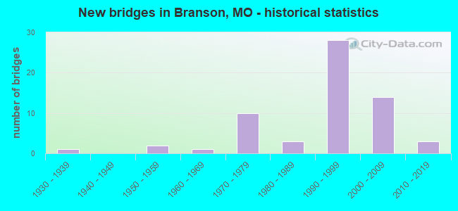
- New bridges - historical statistics
- 11930-1939
- 21950-1959
- 11960-1969
- 101970-1979
- 31980-1989
- 281990-1999
- 142000-2009
- 32010-2019
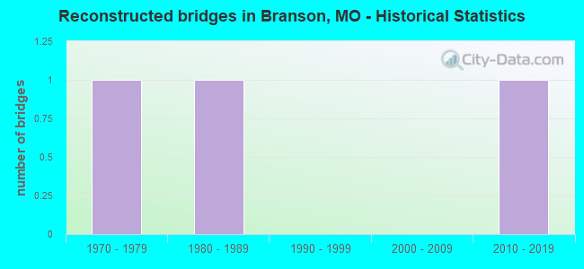
- Reconstructed bridges - Historical Statistics
- 11970-1979
- 11980-1989
- 01990-1999
- 02000-2009
- 12010-2019
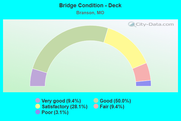
- Bridge Condition - Deck
- 9.4%Very good
- 50.0%Good
- 28.1%Satisfactory
- 9.4%Fair
- 3.1%Poor
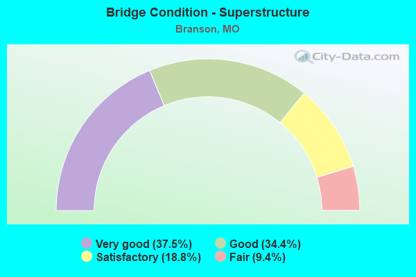
- Bridge Condition - Superstructure
- 37.5%Very good
- 34.4%Good
- 18.8%Satisfactory
- 9.4%Fair

- Bridge Condition - Substructure
- 25.0%Very good
- 43.8%Good
- 18.8%Satisfactory
- 3.1%Fair
- 9.4%Poor
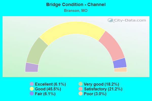
- Bridge Condition - Channel
- 6.1%Excellent
- 18.2%Very good
- 45.5%Good
- 21.2%Satisfactory
- 6.1%Fair
- 3.0%Poor
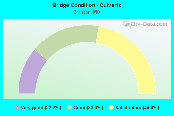
- Bridge Condition - Culverts
- 22.2%Very good
- 33.3%Good
- 44.4%Satisfactory
Find on map >> Show street view
Structure Number: 2634, Location: S 29 T 23 N R 21 W (Lat: 36.657258, Lng: -93.221953), Route carried "under" structure: US 65, Year Built: 1973, Structure Length: 0. m, Average Daily Traffic: 18,888 (year 2021), Truck Traffic: 8%, Features Intersected: US 65, Facility Carried by Structure: MO 248 E
Minimum Vertical Clearance: 4.80m (15.75ft), Kilometerpoint: 483.824, Lanes on structure: 3, Lanes under structure: 2, Material/Design: Steel continuous, Design/Construction: Stringer/Multi-beam, Length of Maximum Span: 32.6m (107.0ft)
Find on map >> Show street view
Structure Number: 2634, Location: S 29 T 23 N R 21 W (Lat: 36.657258, Lng: -93.221953), Route carried "under" structure: US 65, Year Built: 1973, Structure Length: 0. m, Average Daily Traffic: 14,269 (year 2021), Truck Traffic: 7%, Features Intersected: US 65, Facility Carried by Structure: MO 248 E
Minimum Vertical Clearance: 5.11m (16.77ft), Kilometerpoint: 19.980, Lanes on structure: 3, Lanes under structure: 2, Material/Design: Steel continuous, Design/Construction: Stringer/Multi-beam, Length of Maximum Span: 32.6m (107.0ft)
Find on map >> Show street view
Structure Number: 2635, Location: S 32 T 23 N R 21 W (Lat: 36.649947, Lng: -93.224147), Route carried "under" structure: City street , Year Built: 1973, Structure Length: 0. m, Average Daily Traffic: 4,662 (year 2021), Truck Traffic: 5%, Features Intersected: CST CAHILL RD, Facility Carried by Structure: US 65 N
Minimum Vertical Clearance: 4.65m (15.26ft), Kilometerpoint: 1.003, Lanes on structure: 2, Lanes under structure: 2, Material/Design: Steel continuous, Design/Construction: Stringer/Multi-beam, Length of Maximum Span: 21.0m (68.9ft)
Find on map >> Show street view
Structure Number: 2636, Location: S 32 T 23 N R 21 W (Lat: 36.650092, Lng: -93.224317), Route carried "under" structure: City street , Year Built: 1989, Structure Length: 0. m, Average Daily Traffic: 4,662 (year 2021), Truck Traffic: 5%, Features Intersected: CST CAHILL RD, Facility Carried by Structure: US 65 S
Minimum Vertical Clearance: 4.65m (15.26ft), Kilometerpoint: 0.980, Lanes on structure: 2, Lanes under structure: 2, Material/Design: Steel continuous, Design/Construction: Stringer/Multi-beam, Length of Maximum Span: 21.0m (68.9ft)
Find on map >> Show street view
Structure Number: 2637, Location: S 32 T 23 N R 21 W (Lat: 36.644333, Lng: -93.227542), Route carried "under" structure: US 65, Year Built: 1973, Structure Length: 0. m, Average Daily Traffic: 13,729 (year 2021), Truck Traffic: 11%, Features Intersected: US 65, Facility Carried by Structure: MO 76 E
Minimum Vertical Clearance: 5.49m (18.01ft), Kilometerpoint: 18.424, Lanes on structure: 4, Lanes under structure: 3, Material/Design: Prestressed concrete continuous, Design/Construction: Box Beam or Girders - Single/Spread, Length of Maximum Span: 33.8m (110.9ft)
Find on map >> Show street view
Structure Number: 2637, Location: S 32 T 23 N R 21 W (Lat: 36.644333, Lng: -93.227542), Route carried "under" structure: US 65, Year Built: 1973, Structure Length: 0. m, Average Daily Traffic: 14,376 (year 2021), Truck Traffic: 8%, Features Intersected: US 65, Facility Carried by Structure: MO 76 E
Minimum Vertical Clearance: 5.49m (18.01ft), Kilometerpoint: 485.398, Lanes on structure: 4, Lanes under structure: 3, Material/Design: Prestressed concrete continuous, Design/Construction: Box Beam or Girders - Single/Spread, Length of Maximum Span: 33.8m (110.9ft)
Find on map >> Show street view
Structure Number: 2638, Location: S 5 T 22 N R 21 W (Lat: 36.636994, Lng: -93.226075), Route carried "under" structure: US 65, Year Built: 1973, Structure Length: 0. m, Average Daily Traffic: 14,376 (year 2021), Truck Traffic: 8%, Features Intersected: US 65, Facility Carried by Structure: CLIFF DR E
Minimum Vertical Clearance: 5.49m (18.01ft), Kilometerpoint: 486.222, Lanes on structure: 2, Lanes under structure: 2, Material/Design: Steel continuous, Design/Construction: Frame, Length of Maximum Span: 36.0m (118.1ft)
Find on map >> Show street view
Structure Number: 2638, Location: S 5 T 22 N R 21 W (Lat: 36.636994, Lng: -93.226075), Route carried "under" structure: US 65, Year Built: 1973, Structure Length: 0. m, Average Daily Traffic: 28,105 (year 2021), Truck Traffic: 11%, Features Intersected: US 65, Facility Carried by Structure: CLIFF DR E
Minimum Vertical Clearance: 5.49m (18.01ft), Kilometerpoint: 17.597, Lanes on structure: 2, Lanes under structure: 2, Material/Design: Steel continuous, Design/Construction: Frame, Length of Maximum Span: 36.0m (118.1ft)
Find on map >> Show street view
Structure Number: 2639, Location: S 5 T 22 N R 21 W (Lat: 36.633622, Lng: -93.225264), Route carried "under" structure: City street , Year Built: 1973, Structure Length: 0. m, Average Daily Traffic: 176 (year 2021), Truck Traffic: 5%, Features Intersected: CST SUNSET RD, Facility Carried by Structure: US 65 S
Minimum Vertical Clearance: 7.21m (23.65ft), Kilometerpoint: 0.626, Lanes on structure: 2, Lanes under structure: 2, Material/Design: Steel continuous, Design/Construction: Stringer/Multi-beam, Length of Maximum Span: 70.2m (230.3ft)
Find on map >> Show street view
Structure Number: 2639, Location: S 5 T 22 N R 21 W (Lat: 36.633622, Lng: -93.225264), Route carried "under" structure: City street , Year Built: 1973, Structure Length: 0. m, Average Daily Traffic: 406 (year 2021), Truck Traffic: 4%, Features Intersected: CST WILSHIRE DR, Facility Carried by Structure: US 65 S
Minimum Vertical Clearance: 4.57m (14.99ft), Kilometerpoint: 0.272, Lanes on structure: 2, Lanes under structure: 2, Material/Design: Steel continuous, Design/Construction: Stringer/Multi-beam, Length of Maximum Span: 70.2m (230.3ft)
Find on map >> Show street view
Structure Number: 31045, Location: S 5 T 22 N R 21 W (Lat: 36.633747, Lng: -93.225064), Route carried "under" structure: City street , Year Built: 2005, Structure Length: 0. m, Average Daily Traffic: 406 (year 2021), Truck Traffic: 4%, Features Intersected: CST WILSHIRE DR, Facility Carried by Structure: US 65 N
Minimum Vertical Clearance: 4.57m (14.99ft), Kilometerpoint: 0.290, Lanes on structure: 2, Lanes under structure: 2, Material/Design: Steel continuous, Design/Construction: Stringer/Multi-beam, Length of Maximum Span: 70.1m (230.0ft)
Find on map >> Show street view
Structure Number: 31045, Location: S 5 T 22 N R 21 W (Lat: 36.633747, Lng: -93.225064), Route carried "under" structure: City street , Year Built: 2005, Structure Length: 0. m, Average Daily Traffic: 176 (year 2021), Truck Traffic: 5%, Features Intersected: CST SUNSET RD, Facility Carried by Structure: US 65 N
Minimum Vertical Clearance: 6.88m (22.57ft), Kilometerpoint: 0.649, Lanes on structure: 2, Lanes under structure: 2, Material/Design: Steel continuous, Design/Construction: Stringer/Multi-beam, Length of Maximum Span: 70.1m (230.0ft)
Find on map >> Show street view
Structure Number: 4249, Location: S 29 T 23 N R 21 W (Lat: 36.669381, Lng: -93.220997), Route carried "under" structure: US 65, Year Built: 1993, Structure Length: 0. m, Average Daily Traffic: 17,177 (year 2021), Truck Traffic: 11%, Features Intersected: US 65, Facility Carried by Structure: BRANSON HILLS PKWY
Minimum Vertical Clearance: 5.16m (16.93ft), Kilometerpoint: 21.330, Lanes on structure: 5, Lanes under structure: 2, Material/Design: Steel continuous, Design/Construction: Stringer/Multi-beam, Length of Maximum Span: 28.3m (92.8ft)
Find on map >> Show street view
Structure Number: 4249, Location: S 29 T 23 N R 21 W (Lat: 36.669381, Lng: -93.220997), Route carried "under" structure: US 65, Year Built: 1993, Structure Length: 0. m, Average Daily Traffic: 18,888 (year 2021), Truck Traffic: 8%, Features Intersected: US 65, Facility Carried by Structure: BRANSON HILLS PKWY
Minimum Vertical Clearance: 5.26m (17.26ft), Kilometerpoint: 482.490, Lanes on structure: 5, Lanes under structure: 2, Material/Design: Steel continuous, Design/Construction: Stringer/Multi-beam, Length of Maximum Span: 28.3m (92.8ft)
Find on map >> Show street view
Structure Number: 4273, Location: S 8 T 23 N R 21 W (Lat: 36.710889, Lng: -93.228831), Route carried "under" structure: State highway 76, Year Built: 1995, Structure Length: 0. m, Average Daily Traffic: 3,192 (year 2021), Truck Traffic: 5%, Features Intersected: MO 76, Facility Carried by Structure: VICTOR CHURCH RD E
Minimum Vertical Clearance: 5.18m (16.99ft), Kilometerpoint: 165.917, Lanes on structure: 2, Lanes under structure: 2, Material/Design: Steel continuous, Design/Construction: Stringer/Multi-beam, Length of Maximum Span: 36.6m (120.1ft)
Find on map >> Show street view
Structure Number: 4273, Location: S 8 T 23 N R 21 W (Lat: 36.710889, Lng: -93.228831), Route carried "under" structure: State highway 76, Year Built: 1995, Structure Length: 0. m, Average Daily Traffic: 3,280 (year 2021), Truck Traffic: 7%, Features Intersected: MO 76, Facility Carried by Structure: VICTOR CHURCH RD E
Minimum Vertical Clearance: 7.34m (24.08ft), Kilometerpoint: 171.663, Lanes on structure: 2, Lanes under structure: 2, Material/Design: Steel continuous, Design/Construction: Stringer/Multi-beam, Length of Maximum Span: 36.6m (120.1ft)
Find on map >> Show street view
Structure Number: 4274, Location: S 12 T 23 N R 22 W (Lat: 36.714642, Lng: -93.268933), Route carried "under" structure: State highway 76, Year Built: 1996, Structure Length: 0. m, Average Daily Traffic: 3,280 (year 2021), Truck Traffic: 7%, Features Intersected: MO 76, Facility Carried by Structure: MO 248 W
Minimum Vertical Clearance: 6.99m (22.93ft), Kilometerpoint: 175.470, Lanes on structure: 4, Lanes under structure: 2, Material/Design: Prestressed concrete continuous, Design/Construction: Tee Beam, Length of Maximum Span: 33.5m (109.9ft)
Find on map >> Show street view
Structure Number: 4274, Location: S 12 T 23 N R 22 W (Lat: 36.714642, Lng: -93.268933), Route carried "under" structure: State highway 76, Year Built: 1996, Structure Length: 0. m, Average Daily Traffic: 2,976 (year 2021), Truck Traffic: 8%, Features Intersected: MO 76, Facility Carried by Structure: MO 248 W
Minimum Vertical Clearance: 6.91m (22.67ft), Kilometerpoint: 162.114, Lanes on structure: 4, Lanes under structure: 2, Material/Design: Prestressed concrete continuous, Design/Construction: Tee Beam, Length of Maximum Span: 33.5m (109.9ft)
Find on map >> Show street view
Structure Number: 4275, Location: S 21 T 23 N R 22 W (Lat: 36.675517, Lng: -93.317625), Route carried "under" structure: State highway 76, Year Built: 1994, Structure Length: 0. m, Average Daily Traffic: 3,053 (year 2021), Truck Traffic: 7%, Features Intersected: MO 76
Minimum Vertical Clearance: 5.36m (17.59ft), Kilometerpoint: 183.031, Lanes on structure: 5, Lanes under structure: 1, Material/Design: Steel continuous, Design/Construction: Stringer/Multi-beam, Length of Maximum Span: 41.8m (137.1ft)
Find on map >> Show street view
Structure Number: 4313, Location: S 8 T 23 N R 21 W (Lat: 36.711336, Lng: -93.220767), Route carried "under" structure: State highway 76, Year Built: 1995, Structure Length: 0. m, Average Daily Traffic: 7,491 (year 2021), Truck Traffic: 7%, Features Intersected: MO 76, Facility Carried by Structure: US 65 N
Minimum Vertical Clearance: 5.08m (16.67ft), Kilometerpoint: 170.921, Lanes on structure: 2, Lanes under structure: 4, Material/Design: Steel continuous, Design/Construction: Stringer/Multi-beam, Length of Maximum Span: 31.7m (104.0ft)
Find on map >> Show street view
Structure Number: 4329, Location: S 8 T 23 N R 21 W (Lat: 36.711392, Lng: -93.220894), Route carried "under" structure: State highway 76, Year Built: 1995, Structure Length: 0. m, Average Daily Traffic: 7,491 (year 2021), Truck Traffic: 7%, Features Intersected: MO 76, Facility Carried by Structure: US 65 S
Minimum Vertical Clearance: 5.08m (16.67ft), Kilometerpoint: 170.932, Lanes on structure: 2, Lanes under structure: 4, Material/Design: Steel continuous, Design/Construction: Stringer/Multi-beam, Length of Maximum Span: 31.7m (104.0ft)