Bridge Statistics for Bridge City, Louisiana (LA)
Condition, Traffic, Stress, Structural Evaluation, Project Costs
- National Bridge Inventory (NBI) Statistics
- 16Number of bridges
- 1,247ft / 380mTotal length
- 91,984Total average daily traffic
- 4,428Total average daily truck traffic
- National Bridge Inventory (NBI) Registered Bridges for Bridge City
- No street view available for this location
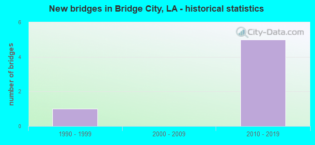
- New bridges - historical statistics
- 11990-1999
- 52010-2019
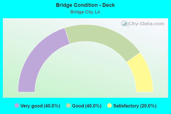
- Bridge Condition - Deck
- 40.0%Very good
- 40.0%Good
- 20.0%Satisfactory
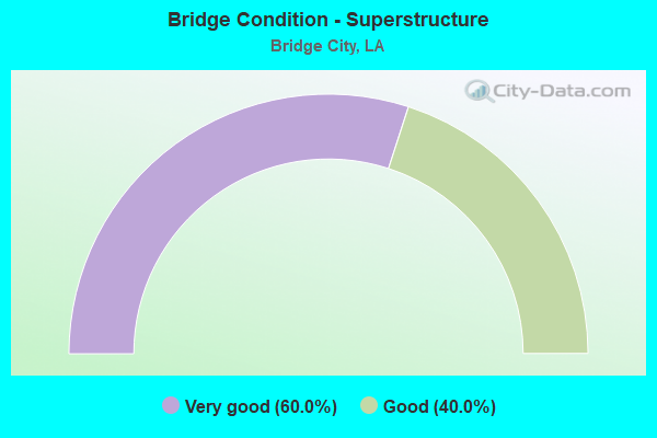
- Bridge Condition - Superstructure
- 60.0%Very good
- 40.0%Good
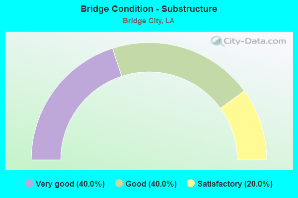
- Bridge Condition - Substructure
- 40.0%Very good
- 40.0%Good
- 20.0%Satisfactory
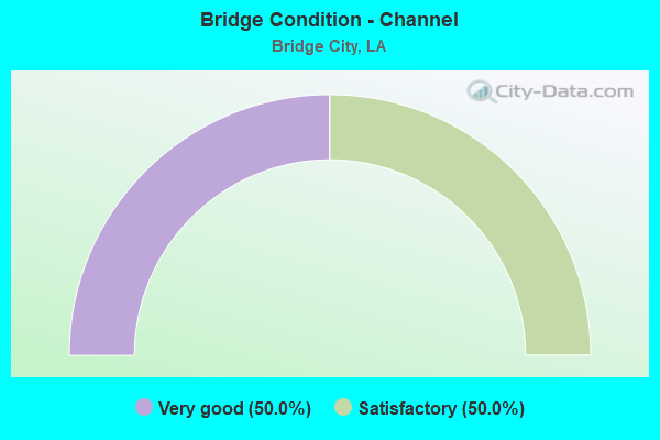
- Bridge Condition - Channel
- 50.0%Very good
- 50.0%Satisfactory
Find on map >> Show street view
Structure Number: 22600000000039, Location: 0.3 MI E OF LA 3017 (Lat: 29.872881, Lng: -90.064100), Route carried "on" structure: County highway , Year Built: 2010, Status: Open, Structure Length: 1.31m (4.30ft), Average Daily Traffic: 1,974 (year 2007), Average Future Daily Traffic: 2,500 (year 2027), Design Load: HL 93, Features Intersected: MURPHY CANAL, Facility Carried by Structure: LAPALCO BLVD
Minimum Vertical Clearance: 30+ m (98+ ft), Kilometerpoint: 0.000, Lanes on structure: 1, Owner: County Highway Agency, Approaching Roadway Width: 6.1m (20.0ft), Material/Design: Concrete, Design/Construction: Culvert, Number Of Spans In Main Unit: 4, Length of Maximum Span: 3.0m (9.8ft), Curb-To-Curb Width: 5.9m (19.4ft), Out-to-Out Width: 15.2m (49.9ft)
Condition: Channel: Very good, Culverts: Satisfactory, Operating Rating: 30.8 metric tons, Method Used To Determine Operating Rating: Load and Resistance Factor Rating (LRFR) rating reported by rating factor(RF) method using HL-93 loadings, Inventory Rating: 24.0 metric tons, Method Used To Determine Inventory Rating: Load and Resistance Factor Rating (LRFR) rating reported by rating factor(RF) method using HL-93 loadings, Structural Evaluation: Equal to present minimum criteria, Deck Geometry: High priority of replacement, Waterway Adequacy: Equal to present desirable criteria, Approach Roadway Alignment: Equal to present desirable criteria, Designated Inspection Frequency: Every 24 months, Inspection Date: August 2021
Find on map >> Show street view
Structure Number: 22600000020493, Location: 1.0 MI S OF THE MISSISSIP (Lat: 29.927450, Lng: -90.166200), Route carried "on" structure: US 90, Year Built: 2013, Status: Open, Structure Length: 157.34m (516.21ft), Average Daily Traffic: 18,450 (year 2016), Truck Traffic: 10%, Average Future Daily Traffic: 37,638 (year 2036), Design Load: HS 20, Features Intersected: LA 18 AND 541
Minimum Vertical Clearance: 30+ m (98+ ft), Kilometerpoint: 0.039, Lanes on structure: 3, Lanes under structure: 9, Base Highway Network: Yes (Inventory Route: 6-01-1, Subroute: 10), Owner: State Highway Agency, Approaching Roadway Width: 10.4m (34.1ft), Skew: 30 degrees, Material/Design: Steel continuous, Design/Construction: Girder and Floorbeam System, Number Of Spans In Main Unit: 5, Number Of Approach Spans: 57, Length of Maximum Span: 70.1m (230.0ft), Curb-To-Curb Width: 10.4m (34.1ft), Out-to-Out Width: 11.0m (36.1ft)
Condition: Deck: Good, Superstructure: Good, Substructure: Good, Operating Rating: 46.7 metric tons, Method Used To Determine Operating Rating: Load and Resistance Factor Rating (LRFR) rating reported by rating factor(RF) method using HL-93 loadings, Inventory Rating: 29.2 metric tons, Method Used To Determine Inventory Rating: Load and Resistance Factor Rating (LRFR) rating reported by rating factor(RF) method using HL-93 loadings, Structural Evaluation: Better than present minimum criteria, Deck Geometry: High priority of replacement, Underclear: Equal to present minimum criteria, Approach Roadway Alignment: Equal to present desirable criteria, Designated Inspection Frequency: Every 24 months, Inspection Date: September 2021, Deck Structure Type: Concrete Cast-file-Place, Wearing Surface/Protective System: Wearing Surface: Monolithic Concrete
Find on map >> Show street view
Structure Number: 22600000020494, Location: 1.0 MI S OF THE MISSISSIP (Lat: 29.941189, Lng: -90.165700), Route carried "on" structure: US 90, Year Built: 2013, Status: Open, Structure Length: 157.34m (516.21ft), Average Daily Traffic: 18,450 (year 2016), Truck Traffic: 10%, Average Future Daily Traffic: 37,638 (year 2036), Design Load: HS 20, Features Intersected: LA 18 AND 541
Minimum Vertical Clearance: 30+ m (98+ ft), Kilometerpoint: 2.313, Lanes on structure: 3, Lanes under structure: 9, Base Highway Network: Yes (Inventory Route: 6-01-2, Subroute: 10), Owner: State Highway Agency, Approaching Roadway Width: 10.4m (34.1ft), Skew: 30 degrees, Material/Design: Steel continuous, Design/Construction: Girder and Floorbeam System, Number Of Spans In Main Unit: 5, Number Of Approach Spans: 54, Length of Maximum Span: 70.1m (230.0ft), Curb-To-Curb Width: 10.4m (34.1ft), Out-to-Out Width: 11.0m (36.1ft)
Condition: Deck: Good, Superstructure: Good, Substructure: Good, Operating Rating: 48.0 metric tons, Method Used To Determine Operating Rating: Load and Resistance Factor Rating (LRFR) rating reported by rating factor(RF) method using HL-93 loadings, Inventory Rating: 33.0 metric tons, Method Used To Determine Inventory Rating: Load and Resistance Factor Rating (LRFR) rating reported by rating factor(RF) method using HL-93 loadings, Structural Evaluation: Better than present minimum criteria, Deck Geometry: High priority of replacement, Underclear: Equal to present minimum criteria, Approach Roadway Alignment: Equal to present desirable criteria, Designated Inspection Frequency: Every 24 months, Inspection Date: September 2021, Deck Structure Type: Concrete Cast-file-Place, Wearing Surface/Protective System: Wearing Surface: Monolithic Concrete
Find on map >> Show street view
Structure Number: 22600000020495, Location: 0.5 MI S EAST OF MISSISSI (Lat: 29.931350, Lng: -90.164500), Route carried "on" structure: Ramp US 90, Year Built: 2013, Status: Open, Structure Length: 31.09m (102.00ft), Average Daily Traffic: 3,690 (year 2016), Truck Traffic: 10%, Average Future Daily Traffic: 6,273 (year 2036), Design Load: HS 20, Features Intersected: GROUND
Minimum Vertical Clearance: 30+ m (98+ ft), Kilometerpoint: 0.172, Lanes on structure: 2, Owner: State Highway Agency, Approaching Roadway Width: 9.8m (32.2ft), Skew: 30 degrees, Material/Design: Prestressed concrete continuous, Design/Construction: Stringer/Multi-beam, Number Of Spans In Main Unit: 9, Number Of Approach Spans: 15, Length of Maximum Span: 24.4m (80.1ft), Curb-To-Curb Width: 9.8m (32.2ft), Out-to-Out Width: 10.4m (34.1ft)
Condition: Deck: Very good, Superstructure: Very good, Substructure: Very good, Operating Rating: 49.2 metric tons, Method Used To Determine Operating Rating: Load and Resistance Factor Rating (LRFR) rating reported by rating factor(RF) method using HL-93 loadings, Inventory Rating: 37.3 metric tons, Method Used To Determine Inventory Rating: Load and Resistance Factor Rating (LRFR) rating reported by rating factor(RF) method using HL-93 loadings, Structural Evaluation: Equal to present desirable criteria, Deck Geometry: Equal to present minimum criteria, Approach Roadway Alignment: Equal to present desirable criteria, Designated Inspection Frequency: Every 24 months, Inspection Date: September 2021, Deck Structure Type: Concrete Cast-file-Place, Wearing Surface/Protective System: Wearing Surface: Monolithic Concrete
Find on map >> Show street view
Structure Number: 22600000020496, Location: 0.5 MI SOUTHWEST OF MISSI (Lat: 29.934100, Lng: -90.164200), Route carried "on" structure: Ramp US 90, Year Built: 2013, Status: Open, Structure Length: 29.69m (97.41ft), Average Daily Traffic: 3,690 (year 2016), Truck Traffic: 10%, Average Future Daily Traffic: 6,273 (year 2036), Design Load: HS 20, Features Intersected: GROUND
Minimum Vertical Clearance: 30+ m (98+ ft), Kilometerpoint: 0.158, Lanes on structure: 2, Owner: State Highway Agency, Approaching Roadway Width: 9.8m (32.2ft), Skew: 30 degrees, Material/Design: Prestressed concrete continuous, Design/Construction: Stringer/Multi-beam, Number Of Spans In Main Unit: 10, Number Of Approach Spans: 10, Length of Maximum Span: 23.5m (77.1ft), Curb-To-Curb Width: 9.8m (32.2ft), Out-to-Out Width: 10.7m (35.1ft)
Condition: Deck: Very good, Superstructure: Very good, Substructure: Very good, Operating Rating: 49.9 metric tons, Method Used To Determine Operating Rating: Load and Resistance Factor Rating (LRFR) rating reported by rating factor(RF) method using HL-93 loadings, Inventory Rating: 38.2 metric tons, Method Used To Determine Inventory Rating: Load and Resistance Factor Rating (LRFR) rating reported by rating factor(RF) method using HL-93 loadings, Structural Evaluation: Equal to present desirable criteria, Deck Geometry: Equal to present minimum criteria, Approach Roadway Alignment: Equal to present desirable criteria, Designated Inspection Frequency: Every 24 months, Inspection Date: September 2021, Deck Structure Type: Concrete Cast-file-Place, Wearing Surface/Protective System: Wearing Surface: Monolithic Concrete
Find on map >> Show street view
Structure Number: 22629541900961, Location: 02268003201281 (Lat: 29.902200, Lng: -90.160100), Route carried "on" structure: County highway , Year Built: 1999, Status: Posted for load, Structure Length: 2.93m (9.61ft), Truck Traffic: 11%, Design Load: H 10, Features Intersected: WHISKY BAYOU, Facility Carried by Structure: B. SEGNETTE ST PK
Minimum Vertical Clearance: 30+ m (98+ ft), Kilometerpoint: 2.060, Lanes on structure: 2, Owner: State Park, Forest, or Reservation Agency, Approaching Roadway Width: 7.3m (24.0ft), Material/Design: Wood or Timber, Design/Construction: Stringer/Multi-beam, Number Of Spans In Main Unit: 6, Length of Maximum Span: 4.9m (16.1ft), Curb or Sidewalk Widths: Left: 0.0m, Right: 1.5m (4.9ft), Curb-To-Curb Width: 7.4m (24.3ft), Out-to-Out Width: 10.1m (33.1ft)
Condition: Deck: Satisfactory, Superstructure: Very good, Substructure: Satisfactory, Channel: Satisfactory, Operating Rating: 21.5 metric tons, Method Used To Determine Operating Rating: Allowable Stress (AS), Inventory Rating: 15.9 metric tons, Method Used To Determine Inventory Rating: Allowable Stress (AS), Structural Evaluation: Meets minimum limits, Deck Geometry: Equal to present minimum criteria, Waterway Adequacy: Equal to present minimum criteria, Approach Roadway Alignment: Equal to present minimum criteria, Bridge Posting: Required (Relationship of Operating Rating to Maximum Legal Load: 20.0 - 29.9% below), Designated Inspection Frequency: Every 24 months, Underwater Inspection Frequency: Every 60 months, Inspection Date: March 2020, Underwater Inspection Date: March 2019, Deck Structure Type: Wood or Timber, Wearing Surface/Protective System: Wearing Surface: Wood or Timber
Find on map >> Show street view
Structure Number: 22600000020493, Location: 0.03 MI S OF LA 18 EB (Lat: 29.929200, Lng: -90.165431), Route carried "under" structure: Ramp US 90, Structure Length: 0. m, Average Daily Traffic: 1,730 (year 2015), Features Intersected: US 90 NB EXIT TO US 90 S
Minimum Vertical Clearance: 6.25m (20.51ft), Kilometerpoint: 0.013, Lanes on structure: 2, Lanes under structure: 1, Length of Maximum Span: 0.0m
Find on map >> Show street view
Structure Number: 22600000020493, Location: 0.75 MA E OF LA 541 (Lat: 29.929700, Lng: -90.165369), Route carried "under" structure: State highway 18, Structure Length: 0. m, Average Daily Traffic: 8,650 (year 2014), Features Intersected: LA 18 EB UNDER US 90 NB
Minimum Vertical Clearance: 5.97m (19.59ft), Kilometerpoint: 0.375, Lanes on structure: 2, Lanes under structure: 2, Length of Maximum Span: 0.0m
Find on map >> Show street view
Structure Number: 22600000020493, Location: 1.30 MI W OF RIVER (Lat: 29.929700, Lng: -90.165369), Route carried "under" structure: State highway 18, Structure Length: 0. m, Average Daily Traffic: 8,650 (year 2014), Features Intersected: LA 18 WB UNDER US 90 NB
Minimum Vertical Clearance: 5.97m (19.59ft), Kilometerpoint: 8.554, Lanes on structure: 2, Lanes under structure: 2, Length of Maximum Span: 0.0m
Find on map >> Show street view
Structure Number: 22600000020493, Location: 1.84 MI NE OF LA 18 (Lat: 29.941339, Lng: -90.165450), Route carried "under" structure: State highway 541, Structure Length: 0. m, Average Daily Traffic: 1,030 (year 2014), Features Intersected: LA 541 UNDER US 90 NB @
Minimum Vertical Clearance: 30+ m (98+ ft), Kilometerpoint: 5.200, Lanes on structure: 3, Lanes under structure: 2, Length of Maximum Span: 0.0m
Find on map >> Show street view
Structure Number: 22600000020494, Location: 0.01 MI S OF LA 18 EB (Lat: 29.929481, Lng: -90.165889), Route carried "under" structure: Ramp US 90, Structure Length: 0. m, Average Daily Traffic: 1,730 (year 2015), Features Intersected: US 90 NB EXIT TO US 90 S
Minimum Vertical Clearance: 6.25m (20.51ft), Kilometerpoint: 0.068, Lanes on structure: 2, Lanes under structure: 1, Length of Maximum Span: 0.0m
Find on map >> Show street view
Structure Number: 22600000020494, Location: 1.83 MI NE OF LA 18 (Lat: 29.941069, Lng: -90.065761), Route carried "under" structure: State highway 541, Structure Length: 0. m, Average Daily Traffic: 1,030 (year 2014), Features Intersected: LA 541 UNDER US 90 SB @
Minimum Vertical Clearance: 30+ m (98+ ft), Kilometerpoint: 5.242, Lanes on structure: 3, Lanes under structure: 2, Length of Maximum Span: 0.0m
Find on map >> Show street view
Structure Number: 22600000020494, Location: 1.33 MI W OF RIVER (Lat: 29.930081, Lng: -90.165639), Route carried "under" structure: State highway 18, Structure Length: 0. m, Average Daily Traffic: 8,650 (year 2014), Features Intersected: LA 18 WB UNDER US 90 SB
Minimum Vertical Clearance: 6.07m (19.91ft), Kilometerpoint: 8.604, Lanes on structure: 2, Lanes under structure: 2, Length of Maximum Span: 0.0m
Find on map >> Show street view
Structure Number: 22600000020494, Location: 0.70 MI E OF LA 541 (Lat: 29.929731, Lng: -90.165919), Route carried "under" structure: State highway 18, Structure Length: 0. m, Average Daily Traffic: 8,650 (year 2014), Features Intersected: LA 18 EB UNDER US 90 SB
Minimum Vertical Clearance: 6.13m (20.11ft), Kilometerpoint: 0.322, Lanes on structure: 2, Lanes under structure: 2, Length of Maximum Span: 0.0m
Find on map >> Show street view
Structure Number: 22600051005871, Location: 1.0 MI SW OF LA 541 (Lat: 29.914839, Lng: -90.174431), Route carried "under" structure: Ramp US 90, Structure Length: 0. m, Average Daily Traffic: 1,730 (year 2014), Features Intersected: US 90 SB OFF RAMP TO US
Minimum Vertical Clearance: 5.18m (16.99ft), Kilometerpoint: 0.632, Lanes on structure: 4, Lanes under structure: 2, Length of Maximum Span: 0.0m
Find on map >> Show street view
Structure Number: 22600051005871, Location: 5.0 MI W OF LA 45 (Lat: 29.914831, Lng: -90.174231), Route carried "under" structure: Ramp US 90, Structure Length: 0. m, Average Daily Traffic: 3,880 (year 2014), Features Intersected: US 90 B WB OFF RAMP TO U
Minimum Vertical Clearance: 5.67m (18.60ft), Kilometerpoint: 14.915, Lanes on structure: 4, Lanes under structure: 2, Length of Maximum Span: 0.0m