Bridge Statistics for Bridgeton, Missouri (MO)
Condition, Traffic, Stress, Structural Evaluation, Project Costs
- National Bridge Inventory (NBI) Statistics
- 108Number of bridges
- 1,506ft / 459mTotal length
- $25,537,000Total costs
- 3,204,669Total average daily traffic
- 396,324Total average daily truck traffic
- National Bridge Inventory (NBI) Registered Bridges for Bridgeton
- No street view available for this location
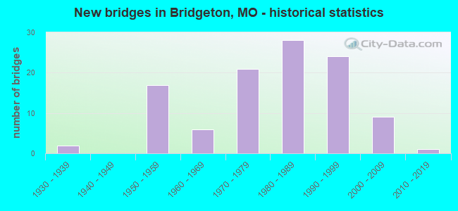
- New bridges - historical statistics
- 21930-1939
- 171950-1959
- 61960-1969
- 211970-1979
- 281980-1989
- 241990-1999
- 92000-2009
- 12010-2019
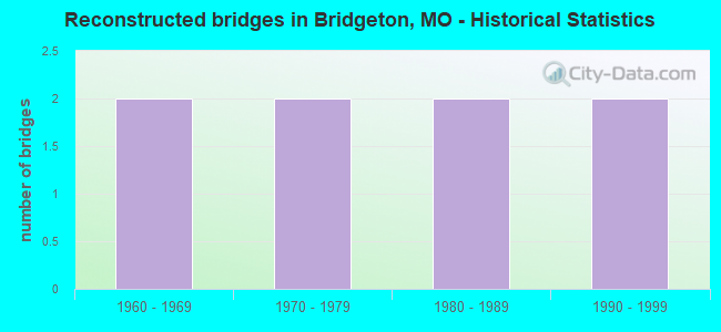
- Reconstructed bridges - Historical Statistics
- 21960-1969
- 21970-1979
- 21980-1989
- 21990-1999
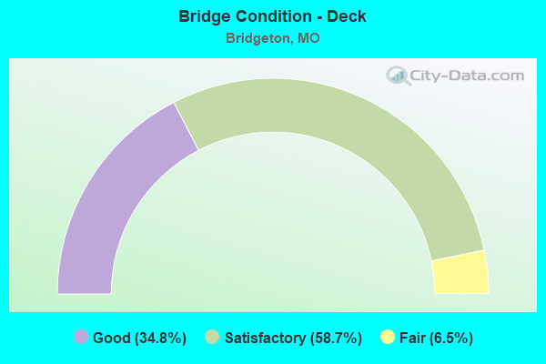
- Bridge Condition - Deck
- 34.8%Good
- 58.7%Satisfactory
- 6.5%Fair
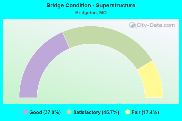
- Bridge Condition - Superstructure
- 37.0%Good
- 45.7%Satisfactory
- 17.4%Fair
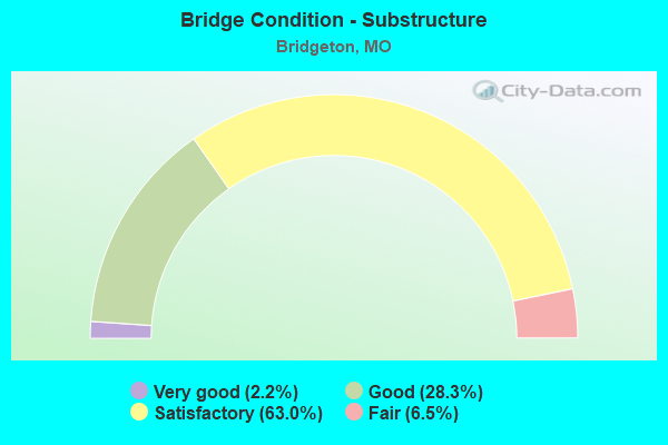
- Bridge Condition - Substructure
- 2.2%Very good
- 28.3%Good
- 63.0%Satisfactory
- 6.5%Fair
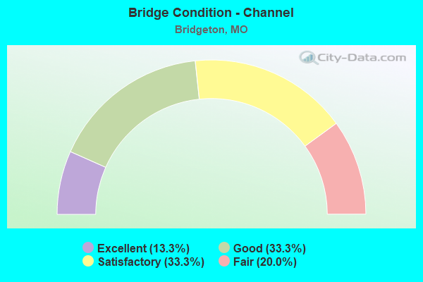
- Bridge Condition - Channel
- 13.3%Excellent
- 33.3%Good
- 33.3%Satisfactory
- 20.0%Fair
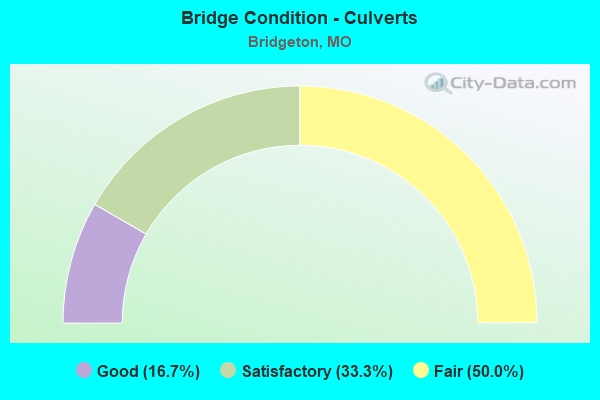
- Bridge Condition - Culverts
- 16.7%Good
- 33.3%Satisfactory
- 50.0%Fair
Find on map >> Show street view
Structure Number: 3992, Location: S 2039 T 46 N R 5 E (Lat: 38.770631, Lng: -90.402000), Route carried "on" structure: Ramp State highway , Year Built: 1991, Status: Open, Structure Length: 5.43m (17.81ft), Average Daily Traffic: 5,814 (year 2021), Truck Traffic: 18%, Average Future Daily Traffic: 7,268 (year 2041), Design Load: HS 20+Mod, Features Intersected: NS RR, Facility Carried by Structure: RP IS270E TO MISSO
Minimum Vertical Clearance: 30+ m (98+ ft), Kilometerpoint: 0.869, Lanes on structure: 2, Base Highway Network: Yes, Owner: State Highway Agency, Approaching Roadway Width: 12.2m (40.0ft), Skew: 1 degrees, Material/Design: Prestressed concrete continuous, Design/Construction: Stringer/Multi-beam, Number Of Spans In Main Unit: 3, Length of Maximum Span: 18.2m (59.7ft), Curb or Sidewalk Widths: Left: 0.2m (0.7ft), Right: 0.2m (0.7ft), Curb-To-Curb Width: 11.8m (38.7ft), Out-to-Out Width: 12.6m (41.3ft)
Condition: Deck: Satisfactory, Superstructure: Good, Substructure: Good, Operating Rating: 70.2 metric tons, Method Used To Determine Operating Rating: Load Factor (LF), Inventory Rating: 37.8 metric tons, Method Used To Determine Inventory Rating: Load Factor (LF), Structural Evaluation: Better than present minimum criteria, Deck Geometry: Superior to present desirable criteria, Underclear: Equal to present minimum criteria, Approach Roadway Alignment: Equal to present desirable criteria, Designated Inspection Frequency: Every 24 months, Inspection Date: August 2020, Deck Structure Type: Concrete Cast-file-Place, Wearing Surface/Protective System: Wearing Surface: Epoxy Overlay, Deck Protection: Epoxy Coated Reinforcing
Find on map >> Show street view
Structure Number: 3997, Location: S 2038 T 47 N R 5 E (Lat: 38.792236, Lng: -90.452283), Route carried "on" structure: State highway 141, Year Built: 1991, Status: Open, Structure Length: 9.11m (29.89ft), Average Daily Traffic: 16,990 (year 2021), Truck Traffic: 21%, Average Future Daily Traffic: 21,238 (year 2041), Design Load: HS 20+Mod, Features Intersected: MO 370
Minimum Vertical Clearance: 30+ m (98+ ft), Kilometerpoint: 49.468, Lanes on structure: 6, Lanes under structure: 7, Base Highway Network: Yes, Owner: State Highway Agency, Approaching Roadway Width: 25.6m (84.0ft), Skew: 3 degrees, Material/Design: Steel continuous, Design/Construction: Stringer/Multi-beam, Number Of Spans In Main Unit: 2, Length of Maximum Span: 36.7m (120.4ft), Curb or Sidewalk Widths: Left: 0.2m (0.7ft), Right: 0.2m (0.7ft), Curb-To-Curb Width: 27.7m (90.9ft), Out-to-Out Width: 28.5m (93.5ft)
Condition: Deck: Satisfactory, Superstructure: Satisfactory, Substructure: Satisfactory, Operating Rating: 51.3 metric tons, Method Used To Determine Operating Rating: Load Factor (LF), Inventory Rating: 30.6 metric tons, Method Used To Determine Inventory Rating: Load Factor (LF), Structural Evaluation: Equal to present minimum criteria, Deck Geometry: Equal to present minimum criteria, Underclear: Equal to present minimum criteria, Approach Roadway Alignment: Equal to present desirable criteria, Designated Inspection Frequency: Every 24 months, Inspection Date: August 2020, Deck Structure Type: Concrete Cast-file-Place, Wearing Surface/Protective System: Wearing Surface: Monolithic Concrete, Deck Protection: Epoxy Coated Reinforcing
Find on map >> Show street view
Structure Number: 4014, Location: S 2038 T 47 N R 5 E (Lat: 38.769797, Lng: -90.407239), Route carried "on" structure: Interstate 270, Year Built: 1990, Status: Open, Structure Length: 8.08m (26.51ft), Average Daily Traffic: 60,611 (year 2021), Truck Traffic: 18%, Average Future Daily Traffic: 75,764 (year 2041), Design Load: HS 20+Mod, Features Intersected: RP IS270E TO MO370W
Minimum Vertical Clearance: 5.11m (16.77ft), Kilometerpoint: 20.968, Lanes on structure: 5, Lanes under structure: 1, Base Highway Network: Yes, Owner: State Highway Agency, Approaching Roadway Width: 19.5m (64.0ft), Skew: 4 degrees, Material/Design: Prestressed concrete continuous, Design/Construction: Stringer/Multi-beam, Number Of Spans In Main Unit: 5, Length of Maximum Span: 18.6m (61.0ft), Curb or Sidewalk Widths: Left: 0.2m (0.7ft), Right: 0.2m (0.7ft), Curb-To-Curb Width: 21.3m (69.9ft), Out-to-Out Width: 22.1m (72.5ft)
Condition: Deck: Satisfactory, Superstructure: Good, Substructure: Satisfactory, Operating Rating: 63.0 metric tons, Method Used To Determine Operating Rating: Load Factor (LF), Inventory Rating: 36.0 metric tons, Method Used To Determine Inventory Rating: Load Factor (LF), Structural Evaluation: Equal to present minimum criteria, Deck Geometry: Meets minimum limits, Underclear: Superior to present desirable criteria, Approach Roadway Alignment: Equal to present desirable criteria, Designated Inspection Frequency: Every 24 months, Inspection Date: August 2020, Deck Structure Type: Concrete Cast-file-Place, Wearing Surface/Protective System: Wearing Surface: Epoxy Overlay, Deck Protection: Epoxy Coated Reinforcing
Find on map >> Show street view
Structure Number: 4048, Location: S 2038 T 47 N R 5 E (Lat: 38.788047, Lng: -90.421883), Route carried "on" structure: State highway 370, Year Built: 1990, Status: Open, Structure Length: 5.55m (18.21ft), Average Daily Traffic: 22,098 (year 2021), Truck Traffic: 5%, Average Future Daily Traffic: 27,623 (year 2041), Design Load: HS 20+Mod, Features Intersected: COWMIRE CR
Minimum Vertical Clearance: 30+ m (98+ ft), Kilometerpoint: 17.769, Lanes on structure: 3, Base Highway Network: Yes, Owner: State Highway Agency, Approaching Roadway Width: 17.1m (56.1ft), Skew: 1 degrees, Material/Design: Prestressed concrete continuous, Design/Construction: Stringer/Multi-beam, Number Of Spans In Main Unit: 3, Length of Maximum Span: 21.7m (71.2ft), Curb or Sidewalk Widths: Left: 0.2m (0.7ft), Right: 0.2m (0.7ft), Curb-To-Curb Width: 16.7m (54.8ft), Out-to-Out Width: 17.6m (57.7ft)
Condition: Deck: Satisfactory, Superstructure: Satisfactory, Substructure: Satisfactory, Channel: Good, Operating Rating: 66.6 metric tons, Method Used To Determine Operating Rating: Load Factor (LF), Inventory Rating: 40.5 metric tons, Method Used To Determine Inventory Rating: Load Factor (LF), Structural Evaluation: Equal to present minimum criteria, Deck Geometry: Equal to present minimum criteria, Waterway Adequacy: Equal to present desirable criteria, Approach Roadway Alignment: Equal to present desirable criteria, Designated Inspection Frequency: Every 24 months, Inspection Date: August 2020, Deck Structure Type: Concrete Cast-file-Place, Wearing Surface/Protective System: Wearing Surface: Monolithic Concrete, Deck Protection: Epoxy Coated Reinforcing
Find on map >> Show street view
Structure Number: 4142, Location: S 24 T 46 N R 6 E (Lat: 38.743283, Lng: -90.385481), Route carried "on" structure: Ramp State highway , Year Built: 1994, Status: Open, Structure Length: 5.00m (16.40ft), Average Daily Traffic: 4,603 (year 2021), Truck Traffic: 19%, Average Future Daily Traffic: 5,754 (year 2041), Design Load: HS 20+Mod, Features Intersected: CST CYPRESS RD, Facility Carried by Structure: RP IS70W TO NATURA
Minimum Vertical Clearance: 30+ m (98+ ft), Kilometerpoint: 0.169, Lanes on structure: 1, Lanes under structure: 3, Base Highway Network: Yes, Owner: State Highway Agency, Approaching Roadway Width: 9.1m (29.9ft), Skew: 1 degrees, Material/Design: Prestressed concrete continuous, Design/Construction: Stringer/Multi-beam, Number Of Spans In Main Unit: 3, Length of Maximum Span: 23.2m (76.1ft), Curb or Sidewalk Widths: Left: 0.2m (0.7ft), Right: 0.2m (0.7ft), Curb-To-Curb Width: 8.8m (28.9ft), Out-to-Out Width: 9.6m (31.5ft)
Condition: Deck: Satisfactory, Superstructure: Good, Substructure: Good, Operating Rating: 72.9 metric tons, Method Used To Determine Operating Rating: Load Factor (LF), Inventory Rating: 37.8 metric tons, Method Used To Determine Inventory Rating: Load Factor (LF), Structural Evaluation: Better than present minimum criteria, Deck Geometry: Superior to present desirable criteria, Underclear: Equal to present minimum criteria, Approach Roadway Alignment: Somewhat better than minimum adequacy, Designated Inspection Frequency: Every 24 months, Inspection Date: September 2020, Deck Structure Type: Concrete Cast-file-Place, Wearing Surface/Protective System: Wearing Surface: Monolithic Concrete, Deck Protection: Epoxy Coated Reinforcing
Find on map >> Show street view
Structure Number: 6527, Location: S 9 T 46 N R 6 E (Lat: 38.732733, Lng: -90.349664), Route carried "on" structure: State highway 115, Year Built: 1958, Year Reconstructed: 2004, Status: Open, Structure Length: 6.25m (20.51ft), Average Daily Traffic: 4,936 (year 2021), Truck Traffic: 3%, Average Future Daily Traffic: 6,910 (year 2041), Design Load: H 20, Features Intersected: IS 70
Minimum Vertical Clearance: 30+ m (98+ ft), Kilometerpoint: 16.274, Lanes on structure: 1, Lanes under structure: 3, Base Highway Network: Yes, Owner: State Highway Agency, Approaching Roadway Width: 13.4m (44.0ft), Skew: 4 degrees, Material/Design: Steel continuous, Design/Construction: Stringer/Multi-beam, Number Of Spans In Main Unit: 3, Length of Maximum Span: 24.4m (80.1ft), Curb-To-Curb Width: 8.5m (27.9ft), Out-to-Out Width: 10.0m (32.8ft)
Condition: Deck: Good, Superstructure: Satisfactory, Substructure: Good, Operating Rating: 55.8 metric tons, Method Used To Determine Operating Rating: Load Factor (LF), Inventory Rating: 33.3 metric tons, Method Used To Determine Inventory Rating: Load Factor (LF), Structural Evaluation: Equal to present minimum criteria, Deck Geometry: Meets minimum limits, Underclear: Meets minimum limits, Approach Roadway Alignment: Better than present minimum criteria, Designated Inspection Frequency: Every 24 months, Inspection Date: September 2020, Deck Structure Type: Concrete Cast-file-Place, Wearing Surface/Protective System: Wearing Surface: Monolithic Concrete, Deck Protection: Epoxy Coated Reinforcing
Find on map >> Show street view
Structure Number: 6571, Location: S 12 T 46 N R 5 E (Lat: 38.743878, Lng: -90.412661), Route carried "on" structure: State highway 180, Year Built: 1957, Year Reconstructed: 1973, Status: Open, Structure Length: 15.21m (49.90ft), Average Daily Traffic: 15,452 (year 2021), Truck Traffic: 3%, Average Future Daily Traffic: 21,633 (year 2041), Design Load: HS 20, Features Intersected: IS 70
Minimum Vertical Clearance: 30+ m (98+ ft), Kilometerpoint: 2.570, Lanes on structure: 3, Lanes under structure: 8, Base Highway Network: Yes, Owner: State Highway Agency, Approaching Roadway Width: 14.6m (47.9ft), Skew: 26 degrees, Material/Design: Concrete continuous, Design/Construction: Box Beam or Girders - Single/Spread, Number Of Spans In Main Unit: 4, Length of Maximum Span: 45.7m (149.9ft), Curb or Sidewalk Widths: Left: 1.5m (4.9ft), Right: 1.5m (4.9ft), Curb-To-Curb Width: 11.6m (38.1ft), Out-to-Out Width: 13.4m (44.0ft)
Condition: Deck: Satisfactory, Superstructure: Fair, Substructure: Satisfactory, Operating Rating: 52.2 metric tons, Method Used To Determine Operating Rating: Load Factor (LF), Inventory Rating: 31.5 metric tons, Method Used To Determine Inventory Rating: Load Factor (LF), Structural Evaluation: Somewhat better than minimum adequacy, Deck Geometry: High priority of replacement, Underclear: High priority of corrective action, Approach Roadway Alignment: Better than present minimum criteria, Length Of Structure Improvement: 1.60m (5.25ft), Designated Inspection Frequency: Every 24 months, Inspection Date: September 2020, Bridge Improvement Cost: $2,162,000, Roadway Improvement Cost: $216,000, Total Project Cost: $3,243,000 ( Estimate for 2022), Deck Structure Type: Concrete Cast-file-Place, Wearing Surface/Protective System: Wearing Surface: Latex Concrete, Membrane: Built-up, Deck Protection: Cathodic Protection
Find on map >> Show street view
Structure Number: 6572, Location: S 12 T 46 N R 5 E (Lat: 38.743900, Lng: -90.412356), Route carried "on" structure: State highway 180, Year Built: 1957, Year Reconstructed: 1973, Status: Open, Structure Length: 15.21m (49.90ft), Average Daily Traffic: 11,919 (year 2021), Truck Traffic: 5%, Average Future Daily Traffic: 16,687 (year 2041), Design Load: HS 20, Features Intersected: IS 70
Minimum Vertical Clearance: 30+ m (98+ ft), Kilometerpoint: 13.295, Lanes on structure: 3, Lanes under structure: 8, Base Highway Network: Yes, Owner: State Highway Agency, Approaching Roadway Width: 14.6m (47.9ft), Skew: 26 degrees, Material/Design: Concrete continuous, Design/Construction: Box Beam or Girders - Single/Spread, Number Of Spans In Main Unit: 4, Length of Maximum Span: 45.7m (149.9ft), Curb or Sidewalk Widths: Left: 1.5m (4.9ft), Right: 1.5m (4.9ft), Curb-To-Curb Width: 11.6m (38.1ft), Out-to-Out Width: 13.4m (44.0ft)
Condition: Deck: Satisfactory, Superstructure: Satisfactory, Substructure: Satisfactory, Operating Rating: 52.2 metric tons, Method Used To Determine Operating Rating: Load Factor (LF), Inventory Rating: 31.5 metric tons, Method Used To Determine Inventory Rating: Load Factor (LF), Structural Evaluation: Equal to present minimum criteria, Deck Geometry: High priority of replacement, Underclear: High priority of corrective action, Approach Roadway Alignment: Better than present minimum criteria, Length Of Structure Improvement: 1.60m (5.25ft), Designated Inspection Frequency: Every 24 months, Inspection Date: September 2020, Bridge Improvement Cost: $2,162,000, Roadway Improvement Cost: $216,000, Total Project Cost: $3,243,000 ( Estimate for 2022), Deck Structure Type: Concrete Cast-file-Place, Wearing Surface/Protective System: Wearing Surface: Latex Concrete, Membrane: Built-up, Deck Protection: Cathodic Protection
Find on map >> Show street view
Structure Number: 6573, Location: S 406 T 46 N R 5 E (Lat: 38.743892, Lng: -90.400178), Route carried "on" structure: City street , Year Built: 1957, Year Reconstructed: 1985, Status: Open, Structure Length: 6.89m (22.60ft), Average Daily Traffic: 14,128 (year 2021), Truck Traffic: 5%, Average Future Daily Traffic: 21,192 (year 2041), Design Load: H 15, Features Intersected: IS 70, Facility Carried by Structure: FEE FEE RD S
Minimum Vertical Clearance: 30+ m (98+ ft), Kilometerpoint: 0.919, Lanes on structure: 2, Lanes under structure: 7, Owner: State Highway Agency, Approaching Roadway Width: 7.3m (24.0ft), Material/Design: Concrete continuous, Design/Construction: Box Beam or Girders - Single/Spread, Number Of Spans In Main Unit: 4, Length of Maximum Span: 22.1m (72.5ft), Curb or Sidewalk Widths: Left: 1.5m (4.9ft), Right: 1.5m (4.9ft), Curb-To-Curb Width: 8.5m (27.9ft), Out-to-Out Width: 12.1m (39.7ft)
Condition: Deck: Good, Superstructure: Satisfactory, Substructure: Good, Operating Rating: 55.8 metric tons, Method Used To Determine Operating Rating: Allowable Stress (AS), Inventory Rating: 30.6 metric tons, Method Used To Determine Inventory Rating: Allowable Stress (AS), Structural Evaluation: Equal to present minimum criteria, Deck Geometry: Meets minimum limits, Underclear: Meets minimum limits, Approach Roadway Alignment: Better than present minimum criteria, Designated Inspection Frequency: Every 24 months, Inspection Date: September 2020, Deck Structure Type: Concrete Cast-file-Place, Wearing Surface/Protective System: Wearing Surface: Other
Find on map >> Show street view
Structure Number: 6574, Location: S 12 T 46 N R 5 E (Lat: 38.743608, Lng: -90.395550), Route carried "on" structure: US 67, Year Built: 1957, Status: Open, Structure Length: 7.56m (24.80ft), Average Daily Traffic: 10,716 (year 2021), Truck Traffic: 5%, Average Future Daily Traffic: 15,002 (year 2041), Design Load: HS 20, Features Intersected: IS 70
Minimum Vertical Clearance: 30+ m (98+ ft), Kilometerpoint: 28.798, Lanes on structure: 3, Lanes under structure: 9, Base Highway Network: Yes, Owner: State Highway Agency, Approaching Roadway Width: 14.6m (47.9ft), Skew: 1 degrees, Material/Design: Concrete continuous, Design/Construction: Box Beam or Girders - Single/Spread, Number Of Spans In Main Unit: 4, Length of Maximum Span: 22.6m (74.1ft), Curb-To-Curb Width: 11.2m (36.7ft), Out-to-Out Width: 12.6m (41.3ft)
Condition: Deck: Satisfactory, Superstructure: Satisfactory, Substructure: Satisfactory, Operating Rating: 97.2 metric tons, Method Used To Determine Operating Rating: Load Factor (LF), Inventory Rating: 57.6 metric tons, Method Used To Determine Inventory Rating: Load Factor (LF), Structural Evaluation: Equal to present minimum criteria, Deck Geometry: High priority of replacement, Underclear: Meets minimum limits, Approach Roadway Alignment: Equal to present minimum criteria, Length Of Structure Improvement: 0.86m (2.82ft), Designated Inspection Frequency: Every 24 months, Inspection Date: September 2020, Bridge Improvement Cost: $909,000, Roadway Improvement Cost: $91,000, Total Project Cost: $1,363,000 ( Estimate for 2022), Deck Structure Type: Concrete Cast-file-Place, Wearing Surface/Protective System: Wearing Surface: Other, Deck Protection: Cathodic Protection
Find on map >> Show street view
Structure Number: 6575, Location: S 12 T 46 N R 5 E (Lat: 38.743594, Lng: -90.395419), Route carried "on" structure: US 67, Year Built: 1957, Status: Open, Structure Length: 7.56m (24.80ft), Average Daily Traffic: 18,841 (year 2021), Truck Traffic: 8%, Average Future Daily Traffic: 26,377 (year 2041), Design Load: HS 20, Features Intersected: IS 70
Minimum Vertical Clearance: 30+ m (98+ ft), Kilometerpoint: 289.280, Lanes on structure: 3, Lanes under structure: 9, Base Highway Network: Yes, Owner: State Highway Agency, Approaching Roadway Width: 14.6m (47.9ft), Skew: 1 degrees, Material/Design: Concrete continuous, Design/Construction: Box Beam or Girders - Single/Spread, Number Of Spans In Main Unit: 4, Length of Maximum Span: 22.6m (74.1ft), Curb-To-Curb Width: 11.2m (36.7ft), Out-to-Out Width: 12.6m (41.3ft)
Condition: Deck: Satisfactory, Superstructure: Satisfactory, Substructure: Satisfactory, Operating Rating: 97.2 metric tons, Method Used To Determine Operating Rating: Load Factor (LF), Inventory Rating: 57.6 metric tons, Method Used To Determine Inventory Rating: Load Factor (LF), Structural Evaluation: Equal to present minimum criteria, Deck Geometry: High priority of replacement, Underclear: Meets minimum limits, Approach Roadway Alignment: Somewhat better than minimum adequacy, Length Of Structure Improvement: 0.86m (2.82ft), Designated Inspection Frequency: Every 24 months, Inspection Date: September 2020, Bridge Improvement Cost: $909,000, Roadway Improvement Cost: $91,000, Total Project Cost: $1,363,000 ( Estimate for 2022), Deck Structure Type: Concrete Cast-file-Place, Wearing Surface/Protective System: Wearing Surface: Other, Deck Protection: Cathodic Protection
Find on map >> Show street view
Structure Number: 758, Location: S 131 T 47 N R 5 E (Lat: 38.757686, Lng: -90.433342), Route carried "on" structure: Interstate 270, Year Built: 1960, Year Reconstructed: 1996, Status: Open, Structure Length: 5.64m (18.50ft), Average Daily Traffic: 71,755 (year 2021), Truck Traffic: 18%, Average Future Daily Traffic: 89,694 (year 2041), Design Load: HS 20+Mod, Features Intersected: MO 180
Minimum Vertical Clearance: 30+ m (98+ ft), Kilometerpoint: 33.886, Lanes on structure: 5, Lanes under structure: 6, Base Highway Network: Yes, Owner: State Highway Agency, Approaching Roadway Width: 18.3m (60.0ft), Skew: 11 degrees, Material/Design: Concrete continuous, Design/Construction: Box Beam or Girders - Single/Spread, Number Of Spans In Main Unit: 3, Length of Maximum Span: 26.5m (86.9ft), Curb-To-Curb Width: 12.8m (42.0ft), Out-to-Out Width: 14.3m (46.9ft)
Condition: Deck: Good, Superstructure: Satisfactory, Substructure: Satisfactory, Operating Rating: 61.2 metric tons, Method Used To Determine Operating Rating: Load Factor (LF), Inventory Rating: 36.9 metric tons, Method Used To Determine Inventory Rating: Load Factor (LF), Structural Evaluation: Equal to present minimum criteria, Deck Geometry: High priority of replacement, Underclear: Equal to present minimum criteria, Approach Roadway Alignment: Equal to present desirable criteria, Length Of Structure Improvement: 0.67m (2.20ft), Designated Inspection Frequency: Every 24 months, Inspection Date: August 2020, Bridge Improvement Cost: $1,032,000, Roadway Improvement Cost: $103,000, Total Project Cost: $1,548,000 ( Estimate for 2022), Deck Structure Type: Concrete Cast-file-Place, Wearing Surface/Protective System: Wearing Surface: Epoxy Overlay, Deck Protection: Epoxy Coated Reinforcing
Find on map >> Show street view
Structure Number: 12019, Location: S 24 T 46 N R 6 E (Lat: 38.742992, Lng: -90.385650), Route carried "under" structure: City street , Year Built: 2000, Structure Length: 0. m, Average Daily Traffic: 5,889 (year 2021), Truck Traffic: 5%, Features Intersected: CST CYPRESS RD, Facility Carried by Structure: IS 70 E
Minimum Vertical Clearance: 5.16m (16.93ft), Kilometerpoint: 0.164, Lanes on structure: 7, Lanes under structure: 5, Material/Design: Steel, Design/Construction: Stringer/Multi-beam, Length of Maximum Span: 34.1m (111.9ft)
Find on map >> Show street view
Structure Number: 154, Location: S 131 T 47 N R 5 E (Lat: 38.757800, Lng: -90.433467), Route carried "under" structure: State highway 180, Year Built: 1960, Structure Length: 0. m, Average Daily Traffic: 37,567 (year 2021), Truck Traffic: 5%, Features Intersected: MO 180, Facility Carried by Structure: IS 270 W
Minimum Vertical Clearance: 4.42m (14.50ft), Kilometerpoint: 0.211, Lanes on structure: 3, Lanes under structure: 6, Material/Design: Concrete continuous, Design/Construction: Box Beam or Girders - Single/Spread, Length of Maximum Span: 26.5m (86.9ft)
Find on map >> Show street view
Structure Number: 29667, Location: S 26 T 47 N R 5 E (Lat: 38.787053, Lng: -90.420489), Route carried "under" structure: State highway 370, Year Built: 2003, Structure Length: 0. m, Average Daily Traffic: 22,691 (year 2021), Truck Traffic: 5%, Features Intersected: MO 370, Facility Carried by Structure: WEST ST LOUIS MILL
Minimum Vertical Clearance: 5.18m (16.99ft), Kilometerpoint: 2.615, Lanes on structure: 4, Lanes under structure: 4, Material/Design: Steel continuous, Design/Construction: Stringer/Multi-beam, Length of Maximum Span: 35.1m (115.2ft)
Find on map >> Show street view
Structure Number: 29667, Location: S 26 T 47 N R 5 E (Lat: 38.787053, Lng: -90.420489), Route carried "under" structure: State highway 370, Year Built: 2003, Structure Length: 0. m, Average Daily Traffic: 22,098 (year 2021), Truck Traffic: 5%, Features Intersected: MO 370, Facility Carried by Structure: WEST ST LOUIS MILL
Minimum Vertical Clearance: 5.18m (16.99ft), Kilometerpoint: 17.954, Lanes on structure: 4, Lanes under structure: 3, Material/Design: Steel continuous, Design/Construction: Stringer/Multi-beam, Length of Maximum Span: 35.1m (115.2ft)
Find on map >> Show street view
Structure Number: 3103, Location: S 11 T 46 N R 5 E (Lat: 38.746558, Lng: -90.434017), Route carried "under" structure: Interstate 70, Year Built: 1979, Structure Length: 0. m, Average Daily Traffic: 50,833 (year 2021), Truck Traffic: 11%, Features Intersected: IS 70, Facility Carried by Structure: MCKELVEY RD S
Minimum Vertical Clearance: 5.33m (17.49ft), Kilometerpoint: 27.412, Lanes on structure: 4, Lanes under structure: 3, Material/Design: Steel continuous, Design/Construction: Stringer/Multi-beam, Length of Maximum Span: 30.7m (100.7ft)
Find on map >> Show street view
Structure Number: 3103, Location: S 11 T 46 N R 5 E (Lat: 38.746558, Lng: -90.434017), Route carried "under" structure: Interstate 70, Year Built: 1979, Structure Length: 0. m, Average Daily Traffic: 52,273 (year 2021), Truck Traffic: 9%, Features Intersected: IS 70, Facility Carried by Structure: MCKELVEY RD S
Minimum Vertical Clearance: 5.64m (18.50ft), Kilometerpoint: 375.115, Lanes on structure: 4, Lanes under structure: 3, Material/Design: Steel continuous, Design/Construction: Stringer/Multi-beam, Length of Maximum Span: 30.7m (100.7ft)
Find on map >> Show street view
Structure Number: 3115, Location: S 729 T 46 N R 5 E (Lat: 38.750225, Lng: -90.439058), Route carried "under" structure: Ramp State highway , Year Built: 1979, Structure Length: 0. m, Average Daily Traffic: 22,155 (year 2021), Truck Traffic: 11%, Features Intersected: RP IS70E TO IS270E, Facility Carried by Structure: IS 270 E
Minimum Vertical Clearance: 5.86m (19.23ft), Kilometerpoint: 0.766, Lanes on structure: 4, Lanes under structure: 1, Material/Design: Prestressed concrete continuous, Design/Construction: Stringer/Multi-beam, Length of Maximum Span: 26.0m (85.3ft)
Find on map >> Show street view
Structure Number: 3116, Location: S 729 T 46 N R 5 E (Lat: 38.749917, Lng: -90.439375), Route carried "under" structure: Ramp State highway , Year Built: 1979, Structure Length: 0. m, Average Daily Traffic: 22,155 (year 2021), Truck Traffic: 11%, Features Intersected: RP IS70E TO IS270E, Facility Carried by Structure: IS 270 W
Minimum Vertical Clearance: 5.15m (16.90ft), Kilometerpoint: 0.729, Lanes on structure: 3, Lanes under structure: 1, Material/Design: Prestressed concrete continuous, Design/Construction: Stringer/Multi-beam, Length of Maximum Span: 25.6m (84.0ft)
Find on map >> Show street view
Structure Number: 3117, Location: S 131 T 46 N R 5 E (Lat: 38.757969, Lng: -90.433647), Route carried "under" structure: State highway 180, Year Built: 1982, Structure Length: 0. m, Average Daily Traffic: 37,567 (year 2021), Truck Traffic: 5%, Features Intersected: MO 180, Facility Carried by Structure: RP IS270W TO IS70E
Minimum Vertical Clearance: 4.50m (14.76ft), Kilometerpoint: 0.188, Lanes on structure: 2, Lanes under structure: 6, Material/Design: Prestressed concrete continuous, Design/Construction: Stringer/Multi-beam, Length of Maximum Span: 26.8m (87.9ft)
Find on map >> Show street view
Structure Number: 3118, Location: S 729 T 46 N R 5 E (Lat: 38.747300, Lng: -90.439769), Route carried "under" structure: Ramp State highway , Year Built: 1979, Structure Length: 0. m, Average Daily Traffic: 12,433 (year 2021), Truck Traffic: 16%, Features Intersected: RP IS70W TO IS270W, Facility Carried by Structure: IS 270 E
Minimum Vertical Clearance: 5.23m (17.16ft), Kilometerpoint: 0.847, Lanes on structure: 4, Lanes under structure: 1, Material/Design: Prestressed concrete continuous, Design/Construction: Stringer/Multi-beam, Length of Maximum Span: 24.7m (81.0ft)
Find on map >> Show street view
Structure Number: 312, Location: S 131 T 46 N R 5 E (Lat: 38.753492, Lng: -90.437736), Route carried "under" structure: Ramp State highway , Year Built: 1981, Structure Length: 0. m, Average Daily Traffic: 7,166 (year 2021), Truck Traffic: 7%, Features Intersected: RP IS270E TO MO180, Facility Carried by Structure: RP IS70E TO IS270E
Minimum Vertical Clearance: 5.21m (17.09ft), Kilometerpoint: 0.174, Lanes on structure: 2, Lanes under structure: 1, Material/Design: Steel continuous, Design/Construction: Stringer/Multi-beam, Length of Maximum Span: 32.6m (107.0ft)
Find on map >> Show street view
Structure Number: 3121, Location: S 729 T 46 N R 5 E (Lat: 38.749164, Lng: -90.440992), Route carried "under" structure: Ramp State highway , Year Built: 1978, Structure Length: 0. m, Average Daily Traffic: 22,155 (year 2021), Truck Traffic: 11%, Features Intersected: RP IS70E TO IS270E, Facility Carried by Structure: IS 70 W
Minimum Vertical Clearance: 7.02m (23.03ft), Kilometerpoint: 0.573, Lanes on structure: 3, Lanes under structure: 1, Material/Design: Prestressed concrete continuous, Design/Construction: Stringer/Multi-beam, Length of Maximum Span: 25.9m (85.0ft)
Find on map >> Show street view
Structure Number: 3122, Location: S 729 T 46 N R 5 E (Lat: 38.749125, Lng: -90.441389), Route carried "under" structure: Ramp State highway , Year Built: 1978, Structure Length: 0. m, Average Daily Traffic: 22,155 (year 2021), Truck Traffic: 11%, Features Intersected: RP IS70E TO IS270E, Facility Carried by Structure: IS 70 E
Minimum Vertical Clearance: 5.18m (16.99ft), Kilometerpoint: 0.539, Lanes on structure: 3, Lanes under structure: 1, Material/Design: Prestressed concrete continuous, Design/Construction: Stringer/Multi-beam, Length of Maximum Span: 26.1m (85.6ft)
Find on map >> Show street view
Structure Number: 3123, Location: S 729 T 46 N R 5 E (Lat: 38.748006, Lng: -90.437828), Route carried "under" structure: Ramp State highway , Year Built: 1978, Structure Length: 0. m, Average Daily Traffic: 12,433 (year 2021), Truck Traffic: 16%, Features Intersected: RP IS70W TO IS270W, Facility Carried by Structure: IS 70 W
Minimum Vertical Clearance: 6.48m (21.26ft), Kilometerpoint: 0.650, Lanes on structure: 3, Lanes under structure: 1, Material/Design: Prestressed concrete continuous, Design/Construction: Stringer/Multi-beam, Length of Maximum Span: 24.3m (79.7ft)
Find on map >> Show street view
Structure Number: 3124, Location: S 729 T 46 N R 5 E (Lat: 38.747947, Lng: -90.438178), Route carried "under" structure: Ramp State highway , Year Built: 1978, Structure Length: 0. m, Average Daily Traffic: 12,433 (year 2021), Truck Traffic: 16%, Features Intersected: RP IS70W TO IS270W, Facility Carried by Structure: IS 70 E
Minimum Vertical Clearance: 7.53m (24.70ft), Kilometerpoint: 0.686, Lanes on structure: 3, Lanes under structure: 1, Material/Design: Prestressed concrete continuous, Design/Construction: Stringer/Multi-beam, Length of Maximum Span: 24.3m (79.7ft)
Find on map >> Show street view
Structure Number: 3132, Location: S 131 T 46 N R 5 E (Lat: 38.748589, Lng: -90.437803), Route carried "under" structure: Interstate 70, Year Built: 1982, Structure Length: 0. m, Average Daily Traffic: 52,273 (year 2021), Truck Traffic: 9%, Features Intersected: IS 70
Minimum Vertical Clearance: 5.49m (18.01ft), Kilometerpoint: 374.764, Lanes on structure: 1, Lanes under structure: 4, Material/Design: Steel continuous, Design/Construction: Stringer/Multi-beam, Length of Maximum Span: 46.6m (152.9ft)
Find on map >> Show street view
Structure Number: 3132, Location: S 131 T 46 N R 5 E (Lat: 38.748589, Lng: -90.437803), Route carried "under" structure: Interstate 70, Year Built: 1982, Structure Length: 0. m, Average Daily Traffic: 50,833 (year 2021), Truck Traffic: 11%, Features Intersected: IS 70
Minimum Vertical Clearance: 5.36m (17.59ft), Kilometerpoint: 27.774, Lanes on structure: 1, Lanes under structure: 4, Material/Design: Steel continuous, Design/Construction: Stringer/Multi-beam, Length of Maximum Span: 46.6m (152.9ft)
Find on map >> Show street view
Structure Number: 3132, Location: S 131 T 46 N R 5 E (Lat: 38.748589, Lng: -90.437803), Route carried "under" structure: Interstate 270, Year Built: 1982, Structure Length: 0. m, Average Daily Traffic: 71,755 (year 2021), Truck Traffic: 18%, Features Intersected: IS 270
Minimum Vertical Clearance: 6.50m (21.33ft), Kilometerpoint: 32.873, Lanes on structure: 1, Lanes under structure: 4, Material/Design: Steel continuous, Design/Construction: Stringer/Multi-beam, Length of Maximum Span: 46.6m (152.9ft)
Find on map >> Show street view
Structure Number: 3132, Location: S 131 T 46 N R 5 E (Lat: 38.748589, Lng: -90.437803), Route carried "under" structure: Interstate 270, Year Built: 1982, Structure Length: 0. m, Average Daily Traffic: 84,285 (year 2021), Truck Traffic: 18%, Features Intersected: IS 270
Minimum Vertical Clearance: 5.64m (18.50ft), Kilometerpoint: 24.703, Lanes on structure: 1, Lanes under structure: 4, Material/Design: Steel continuous, Design/Construction: Stringer/Multi-beam, Length of Maximum Span: 46.6m (152.9ft)
Find on map >> Show street view
Structure Number: 3132, Location: S 131 T 46 N R 5 E (Lat: 38.748589, Lng: -90.437803), Route carried "under" structure: Ramp State highway , Year Built: 1982, Structure Length: 0. m, Average Daily Traffic: 22,155 (year 2021), Truck Traffic: 11%, Features Intersected: RP IS70E TO IS270E, Facility Carried by Structure: RP IS270E TO IS70W
Minimum Vertical Clearance: 5.54m (18.18ft), Kilometerpoint: 0.766, Lanes on structure: 1, Lanes under structure: 1, Material/Design: Steel continuous, Design/Construction: Stringer/Multi-beam, Length of Maximum Span: 46.6m (152.9ft)
Find on map >> Show street view
Structure Number: 3132, Location: S 131 T 46 N R 5 E (Lat: 38.748589, Lng: -90.437803), Route carried "under" structure: Ramp State highway , Year Built: 1982, Structure Length: 0. m, Average Daily Traffic: 12,433 (year 2021), Truck Traffic: 16%, Features Intersected: RP IS70W TO IS270W, Facility Carried by Structure: RP IS270E TO IS70W
Minimum Vertical Clearance: 5.54m (18.18ft), Kilometerpoint: 0.650, Lanes on structure: 1, Lanes under structure: 1, Material/Design: Steel continuous, Design/Construction: Stringer/Multi-beam, Length of Maximum Span: 46.6m (152.9ft)
Find on map >> Show street view
Structure Number: 3132, Location: S 131 T 46 N R 5 E (Lat: 38.748589, Lng: -90.437803), Route carried "under" structure: Ramp State highway , Year Built: 1982, Structure Length: 0. m, Average Daily Traffic: 5,260 (year 2021), Truck Traffic: 10%, Features Intersected: RP IS270W TO IS70E, Facility Carried by Structure: RP IS270E TO IS70W
Minimum Vertical Clearance: 5.74m (18.83ft), Kilometerpoint: 2.092, Lanes on structure: 1, Lanes under structure: 1, Material/Design: Steel continuous, Design/Construction: Stringer/Multi-beam, Length of Maximum Span: 46.6m (152.9ft)
Find on map >> Show street view
Structure Number: 3133, Location: S 131 T 46 N R 5 E (Lat: 38.754156, Lng: -90.438767), Route carried "under" structure: Ramp State highway , Year Built: 1982, Structure Length: 0. m, Average Daily Traffic: 6,447 (year 2021), Truck Traffic: 18%, Features Intersected: RP MO180 TO IS270W, Facility Carried by Structure: RP IS270W TO IS70E
Minimum Vertical Clearance: 5.03m (16.50ft), Kilometerpoint: 0.650, Lanes on structure: 2, Lanes under structure: 1, Material/Design: Steel continuous, Design/Construction: Stringer/Multi-beam, Length of Maximum Span: 27.2m (89.2ft)
Find on map >> Show street view
Structure Number: 3134, Location: S 131 T 46 N R 5 E (Lat: 38.748392, Lng: -90.441225), Route carried "under" structure: Ramp State highway , Year Built: 1982, Structure Length: 0. m, Average Daily Traffic: 12,433 (year 2021), Truck Traffic: 16%, Features Intersected: RP IS70W TO IS270W, Facility Carried by Structure: RP IS270W TO IS70E
Minimum Vertical Clearance: 5.22m (17.13ft), Kilometerpoint: 0.875, Lanes on structure: 1, Lanes under structure: 2, Material/Design: Steel continuous, Design/Construction: Stringer/Multi-beam, Length of Maximum Span: 46.6m (152.9ft)
Find on map >> Show street view
Structure Number: 3134, Location: S 131 T 46 N R 5 E (Lat: 38.748392, Lng: -90.441225), Route carried "under" structure: Ramp State highway , Year Built: 1982, Structure Length: 0. m, Average Daily Traffic: 18,784 (year 2021), Truck Traffic: 10%, Features Intersected: RP IS270E TO IS70W, Facility Carried by Structure: RP IS270W TO IS70E
Minimum Vertical Clearance: 5.79m (19.00ft), Kilometerpoint: 0.993, Lanes on structure: 1, Lanes under structure: 2, Material/Design: Steel continuous, Design/Construction: Stringer/Multi-beam, Length of Maximum Span: 46.6m (152.9ft)
Find on map >> Show street view
Structure Number: 3134, Location: S 131 T 46 N R 5 E (Lat: 38.748392, Lng: -90.441225), Route carried "under" structure: Interstate 70, Year Built: 1982, Structure Length: 0. m, Average Daily Traffic: 80,719 (year 2021), Truck Traffic: 12%, Features Intersected: IS 70
Minimum Vertical Clearance: 5.94m (19.49ft), Kilometerpoint: 374.427, Lanes on structure: 1, Lanes under structure: 4, Material/Design: Steel continuous, Design/Construction: Stringer/Multi-beam, Length of Maximum Span: 46.6m (152.9ft)
Find on map >> Show street view
Structure Number: 3134, Location: S 131 T 46 N R 5 E (Lat: 38.748392, Lng: -90.441225), Route carried "under" structure: Interstate 70, Year Built: 1982, Structure Length: 0. m, Average Daily Traffic: 80,429 (year 2021), Truck Traffic: 12%, Features Intersected: IS 70
Minimum Vertical Clearance: 5.53m (18.14ft), Kilometerpoint: 28.114, Lanes on structure: 1, Lanes under structure: 4, Material/Design: Steel continuous, Design/Construction: Stringer/Multi-beam, Length of Maximum Span: 46.6m (152.9ft)
Find on map >> Show street view
Structure Number: 3134, Location: S 131 T 46 N R 5 E (Lat: 38.748392, Lng: -90.441225), Route carried "under" structure: Ramp State highway , Year Built: 1982, Structure Length: 0. m, Average Daily Traffic: 22,155 (year 2021), Truck Traffic: 11%, Features Intersected: RP IS70E TO IS270E, Facility Carried by Structure: RP IS270W TO IS70E
Minimum Vertical Clearance: 5.33m (17.49ft), Kilometerpoint: 0.547, Lanes on structure: 1, Lanes under structure: 2, Material/Design: Steel continuous, Design/Construction: Stringer/Multi-beam, Length of Maximum Span: 46.6m (152.9ft)
Find on map >> Show street view
Structure Number: 31419, Location: S 12 T 46 N R 5 E (Lat: 38.749794, Lng: -90.394508), Route carried "under" structure: US 67, Year Built: 2006, Structure Length: 0. m, Average Daily Traffic: 11,004 (year 2021), Truck Traffic: 5%, Features Intersected: US 67, Facility Carried by Structure: NATURAL BRIDGE RD
Minimum Vertical Clearance: 5.03m (16.50ft), Kilometerpoint: 290.027, Lanes on structure: 4, Lanes under structure: 2, Material/Design: Steel continuous, Design/Construction: Stringer/Multi-beam, Length of Maximum Span: 50.9m (167.0ft)
Find on map >> Show street view
Structure Number: 31419, Location: S 12 T 46 N R 5 E (Lat: 38.749794, Lng: -90.394508), Route carried "under" structure: US 67, Year Built: 2006, Structure Length: 0. m, Average Daily Traffic: 10,861 (year 2021), Truck Traffic: 5%, Features Intersected: US 67, Facility Carried by Structure: NATURAL BRIDGE RD
Minimum Vertical Clearance: 5.03m (16.50ft), Kilometerpoint: 28.088, Lanes on structure: 4, Lanes under structure: 3, Material/Design: Steel continuous, Design/Construction: Stringer/Multi-beam, Length of Maximum Span: 50.9m (167.0ft)
Find on map >> Show street view
Structure Number: 3514, Location: S 2083 T 46 N R 5 E (Lat: 38.762689, Lng: -90.422644), Route carried "under" structure: Interstate 270, Year Built: 1988, Structure Length: 0. m, Average Daily Traffic: 60,611 (year 2021), Truck Traffic: 18%, Features Intersected: IS 270, Facility Carried by Structure: WOODFORD WAY S
Minimum Vertical Clearance: 6.63m (21.75ft), Kilometerpoint: 22.565, Lanes on structure: 2, Lanes under structure: 5, Material/Design: Steel continuous, Design/Construction: Stringer/Multi-beam, Length of Maximum Span: 26.5m (86.9ft)
Find on map >> Show street view
Structure Number: 3514, Location: S 2083 T 46 N R 5 E (Lat: 38.762689, Lng: -90.422644), Route carried "under" structure: Interstate 270, Year Built: 1988, Structure Length: 0. m, Average Daily Traffic: 53,039 (year 2021), Truck Traffic: 18%, Features Intersected: IS 270, Facility Carried by Structure: WOODFORD WAY S
Minimum Vertical Clearance: 6.63m (21.75ft), Kilometerpoint: 35.003, Lanes on structure: 2, Lanes under structure: 5, Material/Design: Steel continuous, Design/Construction: Stringer/Multi-beam, Length of Maximum Span: 26.5m (86.9ft)
Find on map >> Show street view
Structure Number: 3515, Location: S 130 T 46 N R 5 E (Lat: 38.767619, Lng: -90.411786), Route carried "under" structure: Interstate 270, Year Built: 1988, Structure Length: 0. m, Average Daily Traffic: 53,039 (year 2021), Truck Traffic: 18%, Features Intersected: IS 270, Facility Carried by Structure: GIST RD E
Minimum Vertical Clearance: 7.32m (24.02ft), Kilometerpoint: 36.090, Lanes on structure: 2, Lanes under structure: 6, Material/Design: Steel continuous, Design/Construction: Stringer/Multi-beam, Length of Maximum Span: 36.8m (120.7ft)
Find on map >> Show street view
Structure Number: 3515, Location: S 130 T 46 N R 5 E (Lat: 38.767619, Lng: -90.411786), Route carried "under" structure: Interstate 270, Year Built: 1988, Structure Length: 0. m, Average Daily Traffic: 60,611 (year 2021), Truck Traffic: 18%, Features Intersected: IS 270, Facility Carried by Structure: GIST RD E
Minimum Vertical Clearance: 6.10m (20.01ft), Kilometerpoint: 21.461, Lanes on structure: 2, Lanes under structure: 6, Material/Design: Steel continuous, Design/Construction: Stringer/Multi-beam, Length of Maximum Span: 36.8m (120.7ft)
Find on map >> Show street view
Structure Number: 3986, Location: S 2038 T 47 N R 5 E (Lat: 38.789408, Lng: -90.424622), Route carried "under" structure: City street , Year Built: 1990, Structure Length: 0. m, Average Daily Traffic: 13,069 (year 2021), Truck Traffic: 5%, Features Intersected: CST MISSOURI BOTTOM RD, Facility Carried by Structure: MO 370 E
Minimum Vertical Clearance: 4.45m (14.60ft), Kilometerpoint: 3.166, Lanes on structure: 6, Lanes under structure: 2, Material/Design: Steel continuous, Design/Construction: Stringer/Multi-beam, Length of Maximum Span: 37.8m (124.0ft)
Find on map >> Show street view
Structure Number: 3987, Location: S 2038 T 47 N R 5 E (Lat: 38.791547, Lng: -90.443642), Route carried "under" structure: City street , Year Built: 1990, Structure Length: 0. m, Average Daily Traffic: 400 (year 2021), Truck Traffic: 10%, Features Intersected: CST FERGUSON LN, Facility Carried by Structure: MO 370 E
Minimum Vertical Clearance: 4.50m (14.76ft), Kilometerpoint: 2.018, Lanes on structure: 3, Lanes under structure: 2, Material/Design: Prestressed concrete continuous, Design/Construction: Stringer/Multi-beam, Length of Maximum Span: 21.9m (71.9ft)
Find on map >> Show street view
Structure Number: 3988, Location: S 2038 T 47 N R 5 E (Lat: 38.791692, Lng: -90.443828), Route carried "under" structure: City street , Year Built: 1990, Structure Length: 0. m, Average Daily Traffic: 400 (year 2021), Truck Traffic: 10%, Features Intersected: CST FERGUSON LN, Facility Carried by Structure: MO 370 W
Minimum Vertical Clearance: 4.50m (14.76ft), Kilometerpoint: 2.042, Lanes on structure: 3, Lanes under structure: 2, Material/Design: Prestressed concrete continuous, Design/Construction: Stringer/Multi-beam, Length of Maximum Span: 21.9m (71.9ft)
Find on map >> Show street view
Structure Number: 399, Location: S 2039 T 46 N R 5 E (Lat: 38.772158, Lng: -90.403856), Route carried "under" structure: State highway 370, Year Built: 1990, Structure Length: 0. m, Average Daily Traffic: 19,201 (year 2021), Truck Traffic: 22%, Features Intersected: MO 370, Facility Carried by Structure: RP MISSOURI BOTTOM
Minimum Vertical Clearance: 5.13m (16.83ft), Kilometerpoint: 0.283, Lanes on structure: 2, Lanes under structure: 2, Material/Design: Steel continuous, Design/Construction: Stringer/Multi-beam, Length of Maximum Span: 34.7m (113.8ft)
Find on map >> Show street view
Structure Number: 3997, Location: S 2038 T 47 N R 5 E (Lat: 38.792236, Lng: -90.452283), Route carried "under" structure: State highway 370, Year Built: 1991, Structure Length: 0. m, Average Daily Traffic: 25,313 (year 2021), Truck Traffic: 5%, Features Intersected: MO 370, Facility Carried by Structure: MO 141 N
Minimum Vertical Clearance: 5.13m (16.83ft), Kilometerpoint: 15.068, Lanes on structure: 6, Lanes under structure: 3, Material/Design: Steel continuous, Design/Construction: Stringer/Multi-beam, Length of Maximum Span: 36.7m (120.4ft)
Find on map >> Show street view
Structure Number: 3997, Location: S 2038 T 47 N R 5 E (Lat: 38.792236, Lng: -90.452283), Route carried "under" structure: State highway 370, Year Built: 1991, Structure Length: 0. m, Average Daily Traffic: 22,691 (year 2021), Truck Traffic: 5%, Features Intersected: MO 370, Facility Carried by Structure: MO 141 N
Minimum Vertical Clearance: 5.13m (16.83ft), Kilometerpoint: 5.499, Lanes on structure: 6, Lanes under structure: 4, Material/Design: Steel continuous, Design/Construction: Stringer/Multi-beam, Length of Maximum Span: 36.7m (120.4ft)
Find on map >> Show street view
Structure Number: 3998, Location: S 26 T 47 N R 5 E (Lat: 38.780778, Lng: -90.416578), Route carried "under" structure: State highway 370, Year Built: 1991, Structure Length: 0. m, Average Daily Traffic: 22,674 (year 2021), Truck Traffic: 5%, Features Intersected: MO 370, Facility Carried by Structure: TAUSSIG AVE E
Minimum Vertical Clearance: 5.16m (16.93ft), Kilometerpoint: 1.839, Lanes on structure: 3, Lanes under structure: 4, Material/Design: Steel continuous, Design/Construction: Stringer/Multi-beam, Length of Maximum Span: 32.3m (106.0ft)
Find on map >> Show street view
Structure Number: 3998, Location: S 26 T 47 N R 5 E (Lat: 38.780778, Lng: -90.416578), Route carried "under" structure: State highway 370, Year Built: 1991, Structure Length: 0. m, Average Daily Traffic: 22,098 (year 2021), Truck Traffic: 5%, Features Intersected: MO 370, Facility Carried by Structure: TAUSSIG AVE E
Minimum Vertical Clearance: 5.13m (16.83ft), Kilometerpoint: 18.720, Lanes on structure: 3, Lanes under structure: 4, Material/Design: Steel continuous, Design/Construction: Stringer/Multi-beam, Length of Maximum Span: 32.3m (106.0ft)
Find on map >> Show street view
Structure Number: 4014, Location: S 2038 T 47 N R 5 E (Lat: 38.769797, Lng: -90.407239), Route carried "under" structure: Ramp State highway , Year Built: 1990, Structure Length: 0. m, Average Daily Traffic: 6,914 (year 2021), Truck Traffic: 10%, Features Intersected: RP IS270E TO MO370W, Facility Carried by Structure: IS 270 W
Minimum Vertical Clearance: 5.78m (18.96ft), Kilometerpoint: 0.463, Lanes on structure: 5, Lanes under structure: 1, Material/Design: Prestressed concrete continuous, Design/Construction: Stringer/Multi-beam, Length of Maximum Span: 18.6m (61.0ft)
Find on map >> Show street view
Structure Number: 4142, Location: S 24 T 46 N R 6 E (Lat: 38.743283, Lng: -90.385481), Route carried "under" structure: City street , Year Built: 1994, Structure Length: 0. m, Average Daily Traffic: 5,889 (year 2021), Truck Traffic: 5%, Features Intersected: CST CYPRESS RD, Facility Carried by Structure: RP IS70W TO NATURA
Minimum Vertical Clearance: 5.16m (16.93ft), Kilometerpoint: 0.119, Lanes on structure: 1, Lanes under structure: 3, Material/Design: Prestressed concrete continuous, Design/Construction: Stringer/Multi-beam, Length of Maximum Span: 23.2m (76.1ft)
Find on map >> Show street view
Structure Number: 6527, Location: S 9 T 46 N R 6 E (Lat: 38.732733, Lng: -90.349664), Route carried "under" structure: Interstate 70, Year Built: 1958, Structure Length: 0. m, Average Daily Traffic: 59,468 (year 2021), Truck Traffic: 18%, Features Intersected: IS 70, Facility Carried by Structure: MO 115 N
Minimum Vertical Clearance: 4.78m (15.68ft), Kilometerpoint: 382.794, Lanes on structure: 1, Lanes under structure: 3, Material/Design: Steel continuous, Design/Construction: Stringer/Multi-beam, Length of Maximum Span: 24.4m (80.1ft)
Find on map >> Show street view
Structure Number: 6571, Location: S 12 T 46 N R 5 E (Lat: 38.743878, Lng: -90.412661), Route carried "under" structure: Interstate 70, Year Built: 1957, Structure Length: 0. m, Average Daily Traffic: 52,273 (year 2021), Truck Traffic: 9%, Features Intersected: IS 70, Facility Carried by Structure: MO 180 E
Minimum Vertical Clearance: 4.70m (15.42ft), Kilometerpoint: 377.049, Lanes on structure: 3, Lanes under structure: 4, Material/Design: Concrete continuous, Design/Construction: Box Beam or Girders - Single/Spread, Length of Maximum Span: 45.7m (149.9ft)
Find on map >> Show street view
Structure Number: 6571, Location: S 12 T 46 N R 5 E (Lat: 38.743878, Lng: -90.412661), Route carried "under" structure: Interstate 70, Year Built: 1957, Structure Length: 0. m, Average Daily Traffic: 50,833 (year 2021), Truck Traffic: 11%, Features Intersected: IS 70, Facility Carried by Structure: MO 180 E
Minimum Vertical Clearance: 4.70m (15.42ft), Kilometerpoint: 25.540, Lanes on structure: 3, Lanes under structure: 4, Material/Design: Concrete continuous, Design/Construction: Box Beam or Girders - Single/Spread, Length of Maximum Span: 45.7m (149.9ft)
Find on map >> Show street view
Structure Number: 6572, Location: S 12 T 46 N R 5 E (Lat: 38.743900, Lng: -90.412356), Route carried "under" structure: Interstate 70, Year Built: 1957, Structure Length: 0. m, Average Daily Traffic: 52,273 (year 2021), Truck Traffic: 9%, Features Intersected: IS 70, Facility Carried by Structure: MO 180 W
Minimum Vertical Clearance: 4.70m (15.42ft), Kilometerpoint: 377.072, Lanes on structure: 3, Lanes under structure: 4, Material/Design: Concrete continuous, Design/Construction: Box Beam or Girders - Single/Spread, Length of Maximum Span: 45.7m (149.9ft)
Find on map >> Show street view
Structure Number: 6572, Location: S 12 T 46 N R 5 E (Lat: 38.743900, Lng: -90.412356), Route carried "under" structure: Interstate 70, Year Built: 1957, Structure Length: 0. m, Average Daily Traffic: 46,577 (year 2021), Truck Traffic: 11%, Features Intersected: IS 70, Facility Carried by Structure: MO 180 W
Minimum Vertical Clearance: 4.70m (15.42ft), Kilometerpoint: 25.515, Lanes on structure: 3, Lanes under structure: 4, Material/Design: Concrete continuous, Design/Construction: Box Beam or Girders - Single/Spread, Length of Maximum Span: 45.7m (149.9ft)
Find on map >> Show street view
Structure Number: 6573, Location: S 406 T 46 N R 5 E (Lat: 38.743892, Lng: -90.400178), Route carried "under" structure: Interstate 70, Year Built: 1957, Structure Length: 0. m, Average Daily Traffic: 45,537 (year 2021), Truck Traffic: 9%, Features Intersected: IS 70, Facility Carried by Structure: FEE FEE RD S
Minimum Vertical Clearance: 4.67m (15.32ft), Kilometerpoint: 378.110, Lanes on structure: 2, Lanes under structure: 3, Material/Design: Concrete continuous, Design/Construction: Box Beam or Girders - Single/Spread, Length of Maximum Span: 22.1m (72.5ft)
Find on map >> Show street view
Structure Number: 6573, Location: S 406 T 46 N R 5 E (Lat: 38.743892, Lng: -90.400178), Route carried "under" structure: Interstate 70, Year Built: 1957, Structure Length: 0. m, Average Daily Traffic: 46,577 (year 2021), Truck Traffic: 11%, Features Intersected: IS 70, Facility Carried by Structure: FEE FEE RD S
Minimum Vertical Clearance: 4.73m (15.52ft), Kilometerpoint: 24.428, Lanes on structure: 2, Lanes under structure: 4, Material/Design: Concrete continuous, Design/Construction: Box Beam or Girders - Single/Spread, Length of Maximum Span: 22.1m (72.5ft)
Find on map >> Show street view
Structure Number: 6574, Location: S 12 T 46 N R 5 E (Lat: 38.743608, Lng: -90.395550), Route carried "under" structure: Interstate 70, Year Built: 1957, Structure Length: 0. m, Average Daily Traffic: 45,537 (year 2021), Truck Traffic: 9%, Features Intersected: IS 70, Facility Carried by Structure: US 67 S
Minimum Vertical Clearance: 4.81m (15.78ft), Kilometerpoint: 378.512, Lanes on structure: 3, Lanes under structure: 4, Material/Design: Concrete continuous, Design/Construction: Box Beam or Girders - Single/Spread, Length of Maximum Span: 22.6m (74.1ft)
Find on map >> Show street view
Structure Number: 6574, Location: S 12 T 46 N R 5 E (Lat: 38.743608, Lng: -90.395550), Route carried "under" structure: Interstate 70, Year Built: 1957, Structure Length: 0. m, Average Daily Traffic: 63,325 (year 2021), Truck Traffic: 18%, Features Intersected: IS 70, Facility Carried by Structure: US 67 S
Minimum Vertical Clearance: 4.73m (15.52ft), Kilometerpoint: 24.023, Lanes on structure: 3, Lanes under structure: 5, Material/Design: Concrete continuous, Design/Construction: Box Beam or Girders - Single/Spread, Length of Maximum Span: 22.6m (74.1ft)
Find on map >> Show street view
Structure Number: 6575, Location: S 12 T 46 N R 5 E (Lat: 38.743594, Lng: -90.395419), Route carried "under" structure: Interstate 70, Year Built: 1957, Structure Length: 0. m, Average Daily Traffic: 63,325 (year 2021), Truck Traffic: 18%, Features Intersected: IS 70, Facility Carried by Structure: US 67 N
Minimum Vertical Clearance: 4.75m (15.58ft), Kilometerpoint: 24.011, Lanes on structure: 3, Lanes under structure: 5, Material/Design: Concrete continuous, Design/Construction: Box Beam or Girders - Single/Spread, Length of Maximum Span: 22.6m (74.1ft)
Find on map >> Show street view
Structure Number: 6575, Location: S 12 T 46 N R 5 E (Lat: 38.743594, Lng: -90.395419), Route carried "under" structure: Interstate 70, Year Built: 1957, Structure Length: 0. m, Average Daily Traffic: 45,537 (year 2021), Truck Traffic: 9%, Features Intersected: IS 70, Facility Carried by Structure: US 67 N
Minimum Vertical Clearance: 4.81m (15.78ft), Kilometerpoint: 378.523, Lanes on structure: 3, Lanes under structure: 4, Material/Design: Concrete continuous, Design/Construction: Box Beam or Girders - Single/Spread, Length of Maximum Span: 22.6m (74.1ft)
Find on map >> Show street view
Structure Number: 758, Location: S 131 T 47 N R 5 E (Lat: 38.757686, Lng: -90.433342), Route carried "under" structure: State highway 180, Year Built: 1960, Structure Length: 0. m, Average Daily Traffic: 37,567 (year 2021), Truck Traffic: 5%, Features Intersected: MO 180, Facility Carried by Structure: IS 270 E
Minimum Vertical Clearance: 4.78m (15.68ft), Kilometerpoint: 0.230, Lanes on structure: 5, Lanes under structure: 6, Material/Design: Concrete continuous, Design/Construction: Box Beam or Girders - Single/Spread, Length of Maximum Span: 26.5m (86.9ft)