Bridge Statistics for Brookfield, Vermont (VT)
Condition, Traffic, Stress, Structural Evaluation, Project Costs
- National Bridge Inventory (NBI) Statistics
- 11Number of bridges
- 102ft / 31.4mTotal length
- $5,253,000Total costs
- 69,870Total average daily traffic
- 8,925Total average daily truck traffic
- National Bridge Inventory (NBI) Registered Bridges for Brookfield
- No street view available for this location
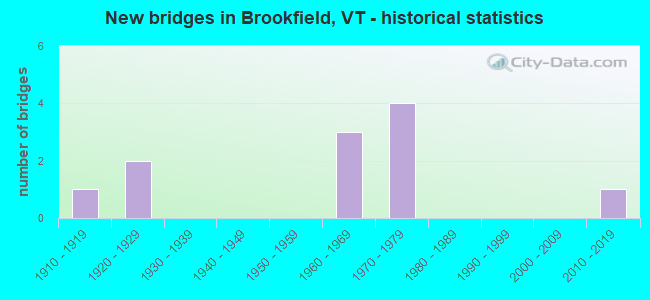
- New bridges - historical statistics
- 11910-1919
- 21920-1929
- 31960-1969
- 41970-1979
- 12010-2019

- Reconstructed bridges - Historical Statistics
- 11930-1939
- 01940-1949
- 01950-1959
- 01960-1969
- 11970-1979
- 01980-1989
- 01990-1999
- 12000-2009
- 12010-2019


- Bridge Condition - Deck
- 33.3%Very good
- 22.2%Good
- 11.1%Satisfactory
- 33.3%Fair

- Bridge Condition - Superstructure
- 22.2%Very good
- 44.4%Good
- 22.2%Satisfactory
- 11.1%Fair

- Bridge Condition - Substructure
- 11.1%Very good
- 33.3%Good
- 22.2%Satisfactory
- 33.3%Fair

- Bridge Condition - Channel
- 25.0%Very good
- 25.0%Good
- 25.0%Satisfactory
- 25.0%Fair
Find on map >> Show street view
Structure Number: 100903002309031, Location: 0.15 MI TO JCT W VT14 (Lat: 44.018589, Lng: -72.573975), Route carried "on" structure: Other road C4033, Year Built: 1919, Year Reconstructed: 2010, Status: Posted for load, Structure Length: 0.76m (2.49ft), Average Daily Traffic: 10 (year 2019), Truck Traffic: 2%, Average Future Daily Traffic: 11 (year 2029), Features Intersected: WHITE RIVER
Minimum Vertical Clearance: 30+ m (98+ ft), Kilometerpoint: 0.000, Lanes on structure: 1, Owner: Town or Township Highway Agency, Approaching Roadway Width: 4.3m (14.1ft), Material/Design: Steel, Design/Construction: Stringer/Multi-beam, Number Of Spans In Main Unit: 1, Length of Maximum Span: 7.0m (23.0ft), Curb-To-Curb Width: 4.2m (13.8ft), Out-to-Out Width: 4.3m (14.1ft)
Condition: Deck: Very good, Superstructure: Satisfactory, Substructure: Fair, Channel: Good, Operating Rating: 6.4 metric tons, Method Used To Determine Operating Rating: Allowable Stress (AS), Inventory Rating: 3.6 metric tons, Method Used To Determine Inventory Rating: Allowable Stress (AS), Structural Evaluation: High priority of replacement, Deck Geometry: Somewhat better than minimum adequacy, Waterway Adequacy: Somewhat better than minimum adequacy, Approach Roadway Alignment: Equal to present desirable criteria, Bridge Posting: Required (Relationship of Operating Rating to Maximum Legal Load: 0.1 - 9.9% below), Length Of Structure Improvement: 1.37m (4.49ft), Designated Inspection Frequency: Every 24 months, Inspection Date: August 2020, Bridge Improvement Cost: $213,000, Roadway Improvement Cost: $150,000, Total Project Cost: $363,000 ( Estimate for 2020), Deck Structure Type: Wood or Timber, Wearing Surface/Protective System: Wearing Surface: Wood or Timber, Deck Protection: Internally Sealed
Find on map >> Show street view
Structure Number: 200089032N09032, Location: 5.5 MI N EXIT 4 (Lat: 44.025731, Lng: -72.615686), Route carried "on" structure: Interstate 89, Year Built: 1968, Year Reconstructed: 2012, Status: Open, Structure Length: 2.10m (6.89ft), Average Daily Traffic: 16,700 (year 2018), Truck Traffic: 13%, Average Future Daily Traffic: 17,535 (year 2028), Design Load: HL 93, Features Intersected: I 89 OVER TH NO 6
Minimum Vertical Clearance: 30+ m (98+ ft), Kilometerpoint: 58.841, Lanes on structure: 2, Lanes under structure: 2, Base Highway Network: Yes, Owner: State Highway Agency, Approaching Roadway Width: 11.9m (39.0ft), Skew: 11 degrees, Material/Design: Steel, Design/Construction: Stringer/Multi-beam, Number Of Spans In Main Unit: 1, Length of Maximum Span: 20.4m (66.9ft), Curb or Sidewalk Widths: Left: 0.2m (0.7ft), Right: 0.2m (0.7ft), Curb-To-Curb Width: 12.3m (40.4ft), Out-to-Out Width: 13.3m (43.6ft)
Condition: Deck: Good, Superstructure: Good, Substructure: Satisfactory, Operating Rating: 87.1 metric tons, Method Used To Determine Operating Rating: Load Factor (LF), Inventory Rating: 51.7 metric tons, Method Used To Determine Inventory Rating: Load Factor (LF), Structural Evaluation: Equal to present minimum criteria, Deck Geometry: Better than present minimum criteria, Underclear: Meets minimum limits, Approach Roadway Alignment: Equal to present desirable criteria, Designated Inspection Frequency: Every 24 months, Inspection Date: May 2020, Deck Structure Type: Concrete Cast-file-Place, Wearing Surface/Protective System: Wearing Surface: Bituminous, Membrane: Preformed Fabric, Deck Protection: Epoxy Coated Reinforcing
Find on map >> Show street view
Structure Number: 200089034N09032, Location: 4.2 MI S EXIT 5 (Lat: 44.057247, Lng: -72.605236), Route carried "on" structure: Interstate 89, Year Built: 1970, Status: Open, Structure Length: 3.72m (12.20ft), Average Daily Traffic: 16,700 (year 2018), Truck Traffic: 13%, Average Future Daily Traffic: 17,535 (year 2028), Design Load: HS 20, Features Intersected: I 89 OVER TH NO 1
Minimum Vertical Clearance: 30+ m (98+ ft), Kilometerpoint: 62.494, Lanes on structure: 2, Lanes under structure: 2, Base Highway Network: Yes, Owner: State Highway Agency, Approaching Roadway Width: 12.5m (41.0ft), Skew: 13 degrees, Material/Design: Steel, Design/Construction: Stringer/Multi-beam, Number Of Spans In Main Unit: 1, Length of Maximum Span: 35.1m (115.2ft), Curb or Sidewalk Widths: Left: 0.2m (0.7ft), Right: 0.2m (0.7ft), Curb-To-Curb Width: 12.5m (41.0ft), Out-to-Out Width: 13.3m (43.6ft)
Condition: Deck: Fair, Superstructure: Good, Substructure: Fair, Operating Rating: 89.8 metric tons, Method Used To Determine Operating Rating: Load Factor (LF), Inventory Rating: 67.1 metric tons, Method Used To Determine Inventory Rating: Load Factor (LF), Structural Evaluation: Somewhat better than minimum adequacy, Deck Geometry: Better than present minimum criteria, Underclear: High priority of corrective action, Approach Roadway Alignment: Equal to present desirable criteria, Length Of Structure Improvement: 3.72m (12.20ft), Designated Inspection Frequency: Every 24 months, Inspection Date: May 2020, Bridge Improvement Cost: $1,862,000, Roadway Improvement Cost: $50,000, Total Project Cost: $1,912,000 ( Estimate for 2020), Deck Structure Type: Concrete Cast-file-Place, Wearing Surface/Protective System: Wearing Surface: Bituminous
Find on map >> Show street view
Structure Number: 200089034S09032, Location: 4.2 MI S EXIT 5 (Lat: 44.057458, Lng: -72.605842), Route carried "on" structure: Interstate 89, Year Built: 1970, Status: Open, Structure Length: 3.72m (12.20ft), Average Daily Traffic: 16,700 (year 2018), Truck Traffic: 13%, Average Future Daily Traffic: 17,535 (year 2028), Design Load: HS 20, Features Intersected: I 89 OVER TH NO 1
Minimum Vertical Clearance: 30+ m (98+ ft), Kilometerpoint: 62.494, Lanes on structure: 2, Lanes under structure: 2, Base Highway Network: Yes, Owner: State Highway Agency, Approaching Roadway Width: 12.5m (41.0ft), Skew: 13 degrees, Material/Design: Steel, Design/Construction: Stringer/Multi-beam, Number Of Spans In Main Unit: 1, Length of Maximum Span: 35.1m (115.2ft), Curb or Sidewalk Widths: Left: 0.2m (0.7ft), Right: 0.2m (0.7ft), Curb-To-Curb Width: 12.5m (41.0ft), Out-to-Out Width: 13.2m (43.3ft)
Condition: Deck: Fair, Superstructure: Good, Substructure: Fair, Operating Rating: 89.8 metric tons, Method Used To Determine Operating Rating: Load Factor (LF), Inventory Rating: 68.0 metric tons, Method Used To Determine Inventory Rating: Load Factor (LF), Structural Evaluation: Somewhat better than minimum adequacy, Deck Geometry: Better than present minimum criteria, Underclear: Somewhat better than minimum adequacy, Approach Roadway Alignment: Equal to present desirable criteria, Designated Inspection Frequency: Every 24 months, Inspection Date: May 2020, Deck Structure Type: Concrete Cast-file-Place, Wearing Surface/Protective System: Wearing Surface: Bituminous
Find on map >> Show street view
Structure Number: 200147004409032, Location: 6.0 MI N JCT VT 66 (Lat: 44.026675, Lng: -72.571042), Route carried "on" structure: State highway 14, Year Built: 1922, Year Reconstructed: 1978, Status: Open, Structure Length: 0.82m (2.69ft), Average Daily Traffic: 830 (year 2018), Truck Traffic: 6%, Average Future Daily Traffic: 872 (year 2028), Design Load: H 15, Features Intersected: 2ND BRANCH WHITE R.
Minimum Vertical Clearance: 30+ m (98+ ft), Kilometerpoint: 0.000, Lanes on structure: 2, Owner: State Highway Agency, Approaching Roadway Width: 6.7m (22.0ft), Skew: 1 degrees, Material/Design: Concrete, Design/Construction: Tee Beam, Number Of Spans In Main Unit: 1, Length of Maximum Span: 6.7m (22.0ft), Curb-To-Curb Width: 9.0m (29.5ft), Out-to-Out Width: 9.5m (31.2ft)
Condition: Deck: Fair, Superstructure: Fair, Substructure: Satisfactory, Channel: Fair, Operating Rating: 50.8 metric tons, Method Used To Determine Operating Rating: Load Factor (LF), Inventory Rating: 30.8 metric tons, Method Used To Determine Inventory Rating: Load Factor (LF), Structural Evaluation: Somewhat better than minimum adequacy, Deck Geometry: Somewhat better than minimum adequacy, Waterway Adequacy: Equal to present minimum criteria, Approach Roadway Alignment: Equal to present desirable criteria, Length Of Structure Improvement: 0.82m (2.69ft), Designated Inspection Frequency: Every 24 months, Inspection Date: June 2021, Bridge Improvement Cost: $294,000, Roadway Improvement Cost: $50,000, Total Project Cost: $344,000 ( Estimate for 2020), Deck Structure Type: Concrete Cast-file-Place, Wearing Surface/Protective System: Wearing Surface: Bituminous
Find on map >> Show street view
Structure Number: 200241005009032, Location: 6.4 MI N JCT. VT.12A N (Lat: 44.015186, Lng: -72.658783), Route carried "on" structure: State highway 12, Year Built: 1928, Year Reconstructed: 1936, Status: Open, Structure Length: 0.76m (2.49ft), Average Daily Traffic: 580 (year 2018), Truck Traffic: 6%, Average Future Daily Traffic: 609 (year 2028), Design Load: H 15, Features Intersected: OPEN MEADOW BROOK
Minimum Vertical Clearance: 30+ m (98+ ft), Kilometerpoint: 0.000, Lanes on structure: 2, Owner: State Highway Agency, Approaching Roadway Width: 6.7m (22.0ft), Material/Design: Concrete, Design/Construction: Tee Beam, Number Of Spans In Main Unit: 1, Length of Maximum Span: 7.0m (23.0ft), Curb or Sidewalk Widths: Left: 0.2m (0.7ft), Right: 0.2m (0.7ft), Curb-To-Curb Width: 9.9m (32.5ft), Out-to-Out Width: 10.4m (34.1ft)
Condition: Deck: Satisfactory, Superstructure: Satisfactory, Substructure: Good, Channel: Satisfactory, Operating Rating: 76.2 metric tons, Method Used To Determine Operating Rating: Allowable Stress (AS), Inventory Rating: 49.0 metric tons, Method Used To Determine Inventory Rating: Allowable Stress (AS), Structural Evaluation: Equal to present minimum criteria, Deck Geometry: Equal to present minimum criteria, Waterway Adequacy: Equal to present minimum criteria, Approach Roadway Alignment: Equal to present desirable criteria, Designated Inspection Frequency: Every 24 months, Inspection Date: August 2021, Deck Structure Type: Concrete Cast-file-Place, Wearing Surface/Protective System: Wearing Surface: Bituminous
Find on map >> Show street view
Structure Number: 200903000209031, Location: 2.3 MI W JCT. VT.14 (Lat: 44.042517, Lng: -72.604697), Route carried "on" structure: State highway 65, Year Built: 2015, Status: Posted for load, Structure Length: 9.78m (32.09ft), Average Daily Traffic: 150 (year 2018), Truck Traffic: 1%, Average Future Daily Traffic: 158 (year 2028), Design Load: H 10, Features Intersected: SUNSET LAKE
Minimum Vertical Clearance: 30+ m (98+ ft), Kilometerpoint: 0.000, Lanes on structure: 1, Owner: State Highway Agency, Approaching Roadway Width: 7.3m (24.0ft), Material/Design: Wood or Timber, Number Of Spans In Main Unit: 1, Length of Maximum Span: 96.6m (316.9ft), Curb or Sidewalk Widths: Left: 1.5m (4.9ft), Right: 1.5m (4.9ft), Curb-To-Curb Width: 3.7m (12.1ft), Out-to-Out Width: 7.0m (23.0ft)
Condition: Deck: Very good, Superstructure: Very good, Substructure: Very good, Channel: Very good, Operating Rating: 32.7 metric tons, Method Used To Determine Operating Rating: Load and Resistance Factor (LRFR), Inventory Rating: 24.5 metric tons, Method Used To Determine Inventory Rating: Load and Resistance Factor (LRFR), Structural Evaluation: Equal to present minimum criteria, Deck Geometry: High priority of replacement, Waterway Adequacy: Better than present minimum criteria, Approach Roadway Alignment: Equal to present desirable criteria, Bridge Posting: Required (Relationship of Operating Rating to Maximum Legal Load: 0.1 - 9.9% below), Length Of Structure Improvement: 9.78m (32.09ft), Designated Inspection Frequency: Every 24 months, Underwater Inspection Frequency: Every 48 months, Inspection Date: July 2021, Underwater Inspection Date: August 2021, Bridge Improvement Cost: $2,584,000, Roadway Improvement Cost: $50,000, Total Project Cost: $2,634,000 ( Estimate for 2020), Deck Structure Type: Wood or Timber, Wearing Surface/Protective System: Wearing Surface: Wood or Timber, Deck Protection: Internally Sealed
Find on map >> Show street view
Structure Number: 200903001A09031, Location: 2.5 MI W JCT. VT.14 (Lat: 44.043519, Lng: -72.609369), Route carried "on" structure: State highway 65, Year Built: 1970, Status: Open, Structure Length: 6.74m (22.11ft), Average Daily Traffic: 150 (year 2018), Truck Traffic: 3%, Average Future Daily Traffic: 158 (year 2028), Design Load: HS 20, Features Intersected: I 89 UNDER VT 65
Minimum Vertical Clearance: 30+ m (98+ ft), Kilometerpoint: 0.000, Lanes on structure: 2, Lanes under structure: 4, Owner: State Highway Agency, Approaching Roadway Width: 9.8m (32.2ft), Material/Design: Steel continuous, Design/Construction: Stringer/Multi-beam, Number Of Spans In Main Unit: 2, Length of Maximum Span: 35.1m (115.2ft), Curb or Sidewalk Widths: Left: 0.2m (0.7ft), Right: 0.2m (0.7ft), Curb-To-Curb Width: 9.6m (31.5ft), Out-to-Out Width: 10.9m (35.8ft)
Condition: Deck: Good, Superstructure: Good, Substructure: Good, Operating Rating: 89.8 metric tons, Method Used To Determine Operating Rating: Load Factor (LF), Inventory Rating: 61.7 metric tons, Method Used To Determine Inventory Rating: Load Factor (LF), Structural Evaluation: Better than present minimum criteria, Deck Geometry: Equal to present minimum criteria, Underclear: Somewhat better than minimum adequacy, Approach Roadway Alignment: Equal to present desirable criteria, Designated Inspection Frequency: Every 24 months, Inspection Date: May 2020, Deck Structure Type: Concrete Cast-file-Place, Wearing Surface/Protective System: Wearing Surface: Bituminous
Find on map >> Show street view
Structure Number: 200903D31S09031, Location: 5.5 MI N EXIT 4 (Lat: 44.025447, Lng: -72.617803), Route carried "on" structure: County highway TH6, Year Built: 1968, Status: Open, Structure Length: 3.02m (9.91ft), Average Daily Traffic: 200 (year 2019), Truck Traffic: 2%, Average Future Daily Traffic: 210 (year 2029), Design Load: HS 20, Features Intersected: TH NO 6 OVER I 89
Minimum Vertical Clearance: 30+ m (98+ ft), Kilometerpoint: 0.000, Lanes on structure: 2, Lanes under structure: 2, Owner: State Highway Agency, Approaching Roadway Width: 9.1m (29.9ft), Skew: 1 degrees, Material/Design: Steel, Design/Construction: Stringer/Multi-beam, Number Of Spans In Main Unit: 1, Length of Maximum Span: 29.6m (97.1ft), Curb or Sidewalk Widths: Left: 0.5m (1.6ft), Right: 0.5m (1.6ft), Curb-To-Curb Width: 9.1m (29.9ft), Out-to-Out Width: 10.8m (35.4ft)
Condition: Deck: Very good, Superstructure: Very good, Substructure: Good, Operating Rating: 89.8 metric tons, Method Used To Determine Operating Rating: Load Factor (LF), Inventory Rating: 55.3 metric tons, Method Used To Determine Inventory Rating: Load Factor (LF), Structural Evaluation: Better than present minimum criteria, Deck Geometry: Equal to present minimum criteria, Underclear: High priority of corrective action, Approach Roadway Alignment: Equal to present desirable criteria, Designated Inspection Frequency: Every 24 months, Inspection Date: May 2020, Deck Structure Type: Concrete Cast-file-Place, Wearing Surface/Protective System: Wearing Surface: Bituminous
Find on map >> Show street view
Structure Number: 200903001A09031, Location: 2.5 MI W JCT. VT.14 (Lat: 44.043519, Lng: -72.609369), Route carried "under" structure: Interstate 89, Year Built: 1970, Structure Length: 0. m, Average Daily Traffic: 11,900 (year 1998), Truck Traffic: 13%, Features Intersected: I 89 UNDER VT 65, Facility Carried by Structure: VT 00065 ML
Minimum Vertical Clearance: 5.86m (19.23ft), Kilometerpoint: 97.974, Lanes on structure: 2, Material/Design: Steel continuous, Design/Construction: Stringer/Multi-beam, Length of Maximum Span: 35.1m (115.2ft)
Find on map >> Show street view
Structure Number: 200903D31S09031, Location: 5.5 MI N EXIT 4 (Lat: 44.025447, Lng: -72.617803), Route carried "under" structure: Interstate 89, Year Built: 1968, Structure Length: 0. m, Average Daily Traffic: 5,950 (year 1998), Truck Traffic: 13%, Features Intersected: I 89 UNDER TH NO 6, Facility Carried by Structure: TR 00TH6
Minimum Vertical Clearance: 5.38m (17.65ft), Kilometerpoint: 94.611, Lanes on structure: 2, Material/Design: Steel, Design/Construction: Stringer/Multi-beam, Length of Maximum Span: 29.6m (97.1ft)