Brookfield, Vermont
Submit your own pictures of this town and show them to the world
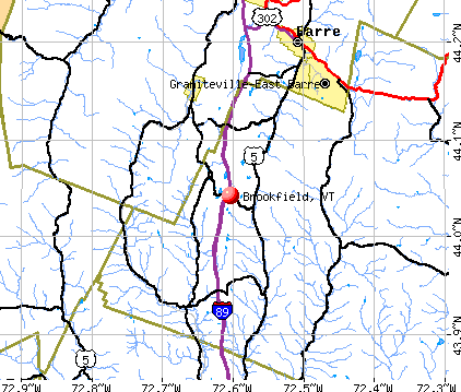
- OSM Map
- General Map
- Google Map
- MSN Map
Population change since 2000: +5.7%
 |
| Males: 675 | |
| Females: 617 |
| Median resident age: | 45.6 years |
| Vermont median age: | 45.8 years |
Zip codes: 05036.
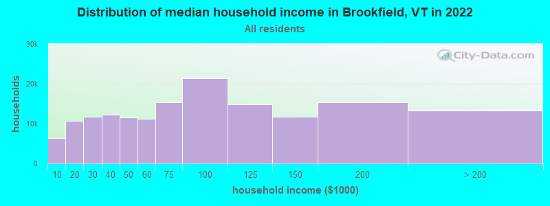
| Brookfield: | $85,092 |
| VT: | $73,991 |
Estimated per capita income in 2022: $44,917 (it was $21,502 in 2000)
Brookfield town income, earnings, and wages data
Estimated median house or condo value in 2022: $303,727 (it was $115,900 in 2000)
| Brookfield: | $303,727 |
| VT: | $304,700 |
Mean prices in 2022: all housing units: $298,331; detached houses: $318,213; townhouses or other attached units: $371,061; in 2-unit structures: $227,224; in 3-to-4-unit structures: over $1,000,000; in 5-or-more-unit structures: $123,307; mobile homes: $108,182
Detailed information about poverty and poor residents in Brookfield, VT


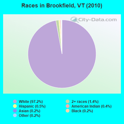
- 1,25697.2%White alone
- 181.4%Two or more races
- 60.5%Hispanic
- 50.4%American Indian alone
- 20.2%Black alone
- 30.2%Asian alone
- 20.2%Other race alone
Races in Brookfield detailed stats: ancestries, foreign born residents, place of birth
According to our research of Vermont and other state lists, there were 4 registered sex offenders living in Brookfield, Vermont as of May 18, 2024.
The ratio of all residents to sex offenders in Brookfield is 323 to 1.
 Recent articles from our blog. Our writers, many of them Ph.D. graduates or candidates, create easy-to-read articles on a wide variety of topics.

 | vacation itinerary recommendations (12 replies) |
| Driving Thru Vermont-Mountain Recommendation(s) (12 replies) |
| Questions About White River Junction Area (49 replies) |
| Vermont Weather (3779 replies) |
| Moving to Vermont in 2 weeks (39 replies) |
| Deciding on if I should move to Vermont... (11 replies) |
Latest news from Brookfield, VT collected exclusively by city-data.com from local newspapers, TV, and radio stations
Ancestries: English (29.7%), Irish (15.0%), French (11.1%), German (9.8%), Italian (6.5%), Scottish (6.1%).
Current Local Time: EST time zone
Elevation: 1276 feet
Land area: 41.4 square miles.
Population density: 31 people per square mile (very low).
10 residents are foreign born
| This town: | 0.8% |
| Vermont: | 3.8% |
| Brookfield town: | 1.5% ($1,694) |
| Vermont: | 2.0% ($2,196) |
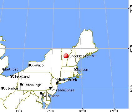
Nearest city with pop. 50,000+: Manchester, NH  (92.0 miles , pop. 107,006).
Nearest city with pop. 200,000+: Boston, MA (140.2 miles , pop. 589,141).
Nearest city with pop. 1,000,000+: Bronx, NY (229.1 miles , pop. 1,332,650).
Nearest cities:
), ), ), ), ), )Latitude: 44.02 N, Longitude: 72.60 W
Area code: 802

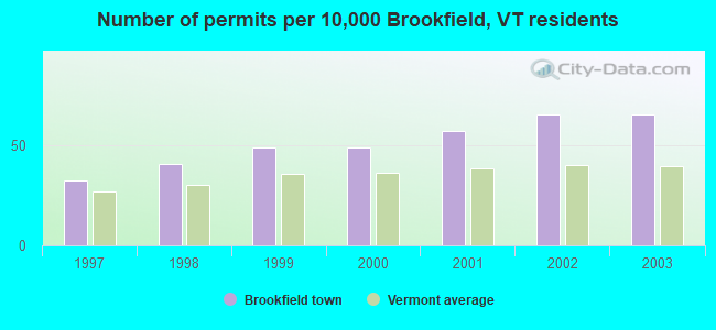
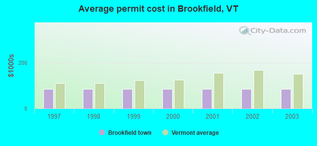
Single-family new house construction building permits:
- 2003: 8 buildings, average cost: $84,700
- 2002: 8 buildings, average cost: $84,700
- 2001: 7 buildings, average cost: $84,700
- 2000: 6 buildings, average cost: $84,700
- 1999: 6 buildings, average cost: $84,700
- 1998: 5 buildings, average cost: $84,700
- 1997: 4 buildings, average cost: $84,700
| Here: | 2.0% |
| Vermont: | 2.0% |
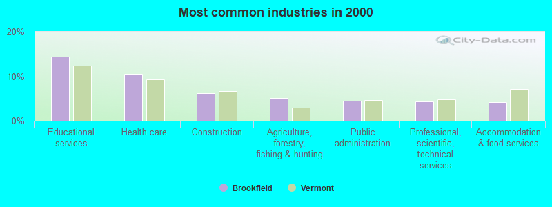
- Educational services (14.4%)
- Health care (10.5%)
- Construction (6.2%)
- Agriculture, forestry, fishing & hunting (5.1%)
- Public administration (4.5%)
- Professional, scientific, technical services (4.4%)
- Accommodation & food services (4.2%)
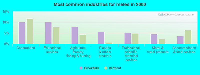
- Construction (10.1%)
- Educational services (10.1%)
- Agriculture, forestry, fishing & hunting (7.9%)
- Plastics & rubber products (5.6%)
- Professional, scientific, technical services (5.1%)
- Metal & metal products (4.5%)
- Accommodation & food services (3.7%)

- Educational services (19.3%)
- Health care (19.0%)
- Religious, grantmaking, civic, professional, similar organizations (6.8%)
- Public administration (5.5%)
- Accommodation & food services (4.8%)
- Finance & insurance (4.5%)
- Social assistance (4.2%)
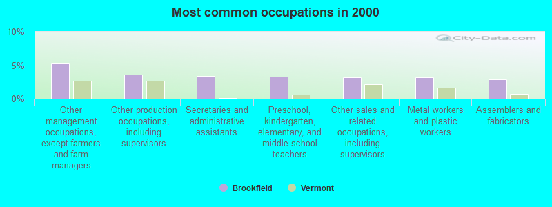
- Other management occupations, except farmers and farm managers (5.3%)
- Other production occupations, including supervisors (3.6%)
- Secretaries and administrative assistants (3.5%)
- Preschool, kindergarten, elementary, and middle school teachers (3.3%)
- Other sales and related occupations, including supervisors (3.2%)
- Metal workers and plastic workers (3.2%)
- Assemblers and fabricators (2.9%)
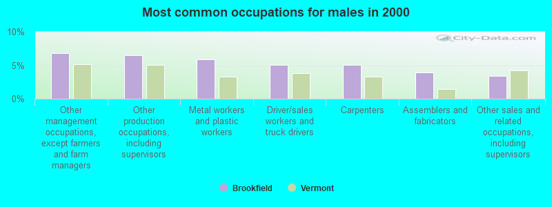
- Other management occupations, except farmers and farm managers (6.8%)
- Other production occupations, including supervisors (6.5%)
- Metal workers and plastic workers (5.9%)
- Driver/sales workers and truck drivers (5.1%)
- Carpenters (5.1%)
- Assemblers and fabricators (3.9%)
- Other sales and related occupations, including supervisors (3.4%)
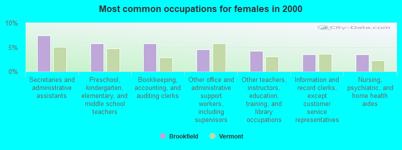
- Secretaries and administrative assistants (7.4%)
- Preschool, kindergarten, elementary, and middle school teachers (5.8%)
- Bookkeeping, accounting, and auditing clerks (5.8%)
- Other office and administrative support workers, including supervisors (4.5%)
- Other teachers, instructors, education, training, and library occupations (4.2%)
- Information and record clerks, except customer service representatives (3.5%)
- Nursing, psychiatric, and home health aides (3.5%)
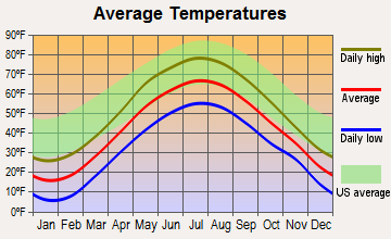
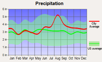
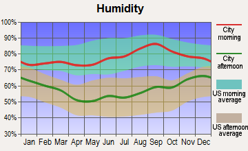
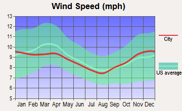
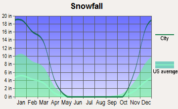
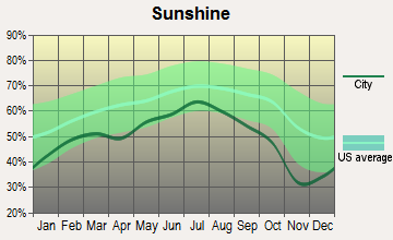
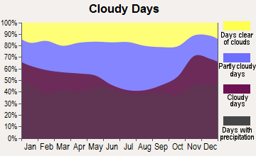
Average climate in Brookfield, Vermont
Based on data reported by over 4,000 weather stations
Earthquake activity:
Brookfield-area historical earthquake activity is significantly above Vermont state average. It is 71% smaller than the overall U.S. average.On 4/20/2002 at 10:50:47, a magnitude 5.3 (5.3 ML, Depth: 3.0 mi, Class: Moderate, Intensity: VI - VII) earthquake occurred 64.0 miles away from the city center
On 4/20/2002 at 10:50:47, a magnitude 5.2 (5.2 MB, 4.2 MS, 5.2 MW, 5.0 MW) earthquake occurred 64.0 miles away from the city center
On 10/7/1983 at 10:18:46, a magnitude 5.3 (5.1 MB, 5.3 LG, 5.1 ML) earthquake occurred 86.8 miles away from Brookfield center
On 1/19/1982 at 00:14:42, a magnitude 4.7 (4.5 MB, 4.7 MD, 4.5 LG, Class: Light, Intensity: IV - V) earthquake occurred 61.7 miles away from the city center
On 10/16/2012 at 23:12:25, a magnitude 4.7 (4.7 ML, Depth: 10.0 mi) earthquake occurred 101.4 miles away from Brookfield center
On 6/16/1995 at 12:13:11, a magnitude 3.8 (3.8 LG, Depth: 3.1 mi, Class: Light, Intensity: II - III) earthquake occurred 38.5 miles away from the city center
Magnitude types: regional Lg-wave magnitude (LG), body-wave magnitude (MB), duration magnitude (MD), local magnitude (ML), surface-wave magnitude (MS), moment magnitude (MW)
Natural disasters:
The number of natural disasters in Orange County (26) is a lot greater than the US average (15).Major Disasters (Presidential) Declared: 19
Emergencies Declared: 1
Causes of natural disasters: Floods: 20, Storms: 19, Tropical Storms: 2, Heavy Rain: 1, Hurricane: 1, Ice Storm: 1, Landslide: 1, Wind: 1, Winter Storm: 1, Other: 1 (Note: some incidents may be assigned to more than one category).
Hospitals and medical centers near Brookfield:
- GIFFORD ELDERLY CARE INC (Nursing Home, about 8 miles away; RANDOLPH, VT)
- GIFFORD MEDICAL CENTER Critical Access Hospitals (about 9 miles away; RANDOLPH, VT)
- MENIG EXTENDED CARE (Nursing Home, about 9 miles away; RANDOLPH, VT)
- MAYO HEALTHCARE INC. (Nursing Home, about 10 miles away; NORTHFIELD, VT)
- ROWAN COURT HEALTH AND REHAB (Nursing Home, about 13 miles away; BARRE, VT)
- HILL ICF/MR (Hospital, about 13 miles away; BARRE, VT)
- CENTRAL VERMONT HOME HEALTH AND HOSPICE (Home Health Center, about 14 miles away; BARRE, VT)
Amtrak stations near Brookfield:
- 8 miles: RANDOLPH (DEPOT SQ.) . Services: enclosed waiting area, public restrooms, public payphones, snack bar, ATM, free short-term parking, free long-term parking, public transit connection.
- 17 miles: MONTPELIER-BARRE (MONTPELIER, MONTPELIER JCT. RD.) . Services: enclosed waiting area, public restrooms, public payphones, free short-term parking, free long-term parking, call for car rental service, call for taxi service.
Colleges/universities with over 2000 students nearest to Brookfield:
- Norwich University (about 9 miles; Northfield, VT; Full-time enrollment: 4,221)
- Dartmouth College (about 27 miles; Hanover, NH; FT enrollment: 6,030)
- Middlebury College (about 29 miles; Middlebury, VT; FT enrollment: 3,077)
- Castleton State College (about 41 miles; Castleton, VT; FT enrollment: 2,079)
- Saint Michael's College (about 43 miles; Colchester, VT; FT enrollment: 2,336)
- Champlain College (about 44 miles; Burlington, VT; FT enrollment: 2,623)
- University of Vermont (about 44 miles; Burlington, VT; FT enrollment: 11,566)
Public elementary/middle school in Brookfield:
- BROOKFIELD SCHOOL (Students: 108, Location: 1728 RIDGE ROAD, Grades: PK-6)
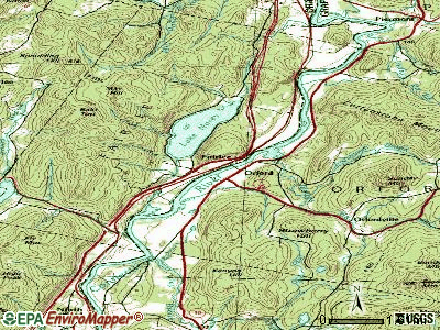
Points of interest:
Notable location: Brookfield Volunteer Fire Department (A). Display/hide its location on the map
Cemeteries: West Brookfield Cemetery (1), East Brookfield Cemetery (2), Brookfield Center Old Cemetery (3), Brookfield Center New Cemetery (4), Center Cemeteries (5). Display/hide their locations on the map
Lakes and reservoirs: Lamson Pond (A), Pickles Pond (B), South Pond (C), North Pond (D), Twin Ponds (E), Wardner Pond (F), Sunset Lake (G), Holdens Pond (H). Display/hide their locations on the map
Streams, rivers, and creeks: Sunset Brook (A), Open Meadow Brook (B), Cold Brook (C). Display/hide their locations on the map
Parks in Brookfield include: Brookfield Historic District (1), Allis State Park (2). Display/hide their locations on the map
| This town: | 2.5 people |
| Vermont: | 2.3 people |
| This town: | 70.6% |
| Whole state: | 62.5% |
| This town: | 10.4% |
| Whole state: | 9.2% |
Likely homosexual households (counted as self-reported same-sex unmarried-partner households)
- Lesbian couples: 0.9% of all households
- Gay men: 0.6% of all households
| This town: | 6.1% |
| Whole state: | 9.4% |
| This town: | 4.6% |
| Whole state: | 3.6% |
For population 15 years and over in Brookfield:
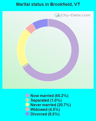
- Never married: 20.7%
- Now married: 65.2%
- Separated: 1.0%
- Widowed: 4.5%
- Divorced: 8.5%
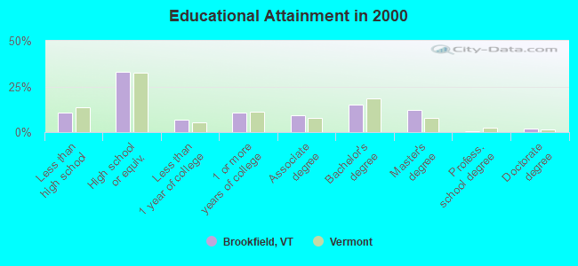
For population 25 years and over in Brookfield:
- High school or higher: 89.5%
- Bachelor's degree or higher: 29.6%
- Graduate or professional degree: 14.8%
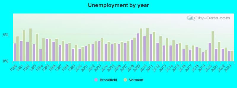
- Unemployed: 5.9%
- Mean travel time to work (commute): 26.4 minutes
| Here: | 11.5 |
| Vermont average: | 11.7 |
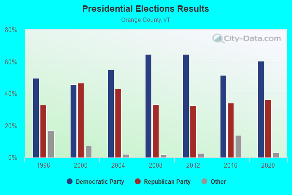
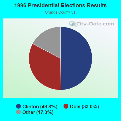
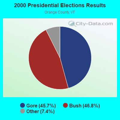
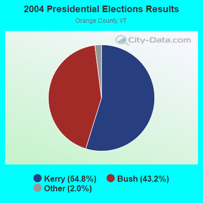
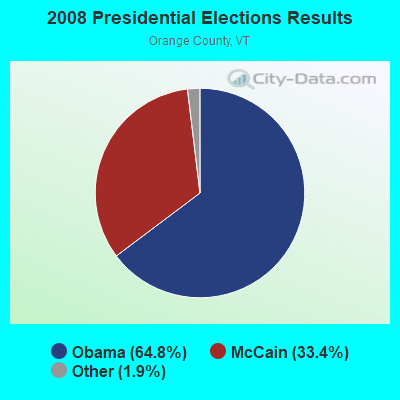
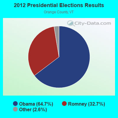
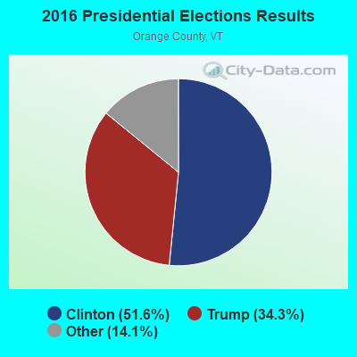
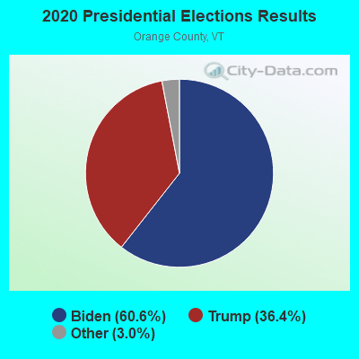
Graphs represent county-level data. Detailed 2008 Election Results
Religion statistics for Brookfield, VT (based on Orange County data)
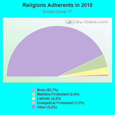
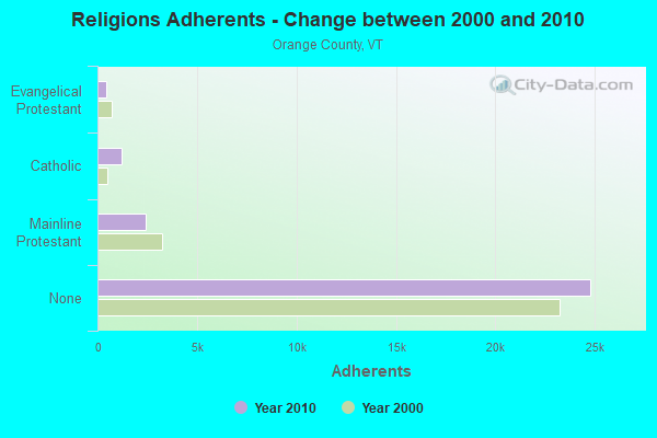
| Religion | Adherents | Congregations |
|---|---|---|
| Mainline Protestant | 2,443 | 33 |
| Catholic | 1,218 | 5 |
| Evangelical Protestant | 438 | 11 |
| Other | 46 | 2 |
| None | 24,791 | - |
Food Environment Statistics:
| Orange County: | 2.76 / 10,000 pop. |
| Vermont: | 3.84 / 10,000 pop. |
| This county: | 1.38 / 10,000 pop. |
| Vermont: | 1.95 / 10,000 pop. |
| Orange County: | 7.60 / 10,000 pop. |
| Vermont: | 6.40 / 10,000 pop. |
| Here: | 7.94 / 10,000 pop. |
| Vermont: | 11.52 / 10,000 pop. |
| Orange County: | 6.9% |
| Vermont: | 6.8% |
| Here: | 25.8% |
| Vermont: | 22.3% |
| This county: | 12.5% |
| Vermont: | 13.3% |
Strongest AM radio stations in Brookfield:
- WWWT (1320 AM; 1 kW; RANDOLPH, VT; Owner: CAPSTAR TX LIMITED PARTNERSHIP)
- WDEV (550 AM; 5 kW; WATERBURY, VT; Owner: RADIO VERMONT, INC.)
- WCHP (760 AM; 35 kW; CHAMPLAIN, NY; Owner: CHAMPLAIN RADIO, INC.)
- WTWN (1100 AM; daytime; 5 kW; WELLS RIVER, VT; Owner: PUFFER BROADCASTING, INC.)
- WGY (810 AM; 50 kW; SCHENECTADY, NY; Owner: CLEAR CHANNEL BROADCASTING LICENSES, INC.)
- WNNZ (640 AM; 50 kW; WESTFIELD, MA; Owner: CLEAR CHANNEL BROADCASTING LICENSES, INC.)
- WSNO (1450 AM; 1 kW; BARRE, VT; Owner: VOX VERMONT, L.L.C)
- WRKO (680 AM; 50 kW; BOSTON, MA; Owner: ENTERCOM BOSTON LICENSE, LLC)
- WNTK (1020 AM; 10 kW; NEWPORT, NH; Owner: KOOR COMMUNICATIONS, INC.)
- WCRN (830 AM; 50 kW; WORCESTER, MA; Owner: CARTER BROADCASTING CORPORATION)
- WICY (1490 AM; 50 kW; MALONE, NY; Owner: CARTIER COMMUNICATIONS INC.)
- WVMT (620 AM; 5 kW; BURLINGTON, VT; Owner: SISON BROADCASTING, INC.)
- WSKI (1240 AM; 1 kW; MONTPELIER, VT; Owner: GALLOWAY COMMUNICATIONS, INC.)
Strongest FM radio stations in Brookfield:
- WCVR-FM (102.1 FM; RANDOLPH, VT; Owner: CAPSTAR TX LIMITED PARTNERSHIP)
- WDEV-FM (96.1 FM; WARREN, VT; Owner: RADIO VERMONT, INC.)
- WCMD (89.9 FM; BARRE, VT; Owner: CHRISTIAN MINISTRIES, INC)
- WEBK (105.3 FM; KILLINGTON, VT; Owner: 6 JOHNSON ROAD LICENSES, INC.)
- WCVT (101.7 FM; STOWE, VT; Owner: RADIO VERMONT CLASSICS, L.L.C.)
- WJJR (98.1 FM; RUTLAND, VT; Owner: 6 JOHNSON ROAD LICENSES, INC.)
- WZRT (97.1 FM; RUTLAND, VT; Owner: CAPSTAR TX LIMITED PARTNERSHIP)
- WGLV (91.7 FM; WOODSTOCK, VT; Owner: CHRISTIAN MINISTRIES INC)
- WHDQ-FM1 (106.1 FM; RUTLAND, VT; Owner: GREAT NORTHERN RADIO, L.L.C.)
- WNCS (104.7 FM; MONTPELIER, VT; Owner: MONTPELIER BROADCASTING, INC.)
- WVPS (107.9 FM; BURLINGTON, VT; Owner: VERMONT PUBLIC RADIO)
- WEZF (92.9 FM; BURLINGTON, VT; Owner: CAPSTAR TX LIMITED PARTNERSHIP)
- WLKC (103.3 FM; WATERBURY, VT; Owner: RADIO BROADCASTING SERVICES, INC.)
- WJEN (94.5 FM; RUTLAND, VT; Owner: 6 JOHNSON ROAD LICENSES, INC.)
- WORK (107.1 FM; BARRE, VT; Owner: VOX VERMONT, L.L.C)
- WVPR (89.5 FM; WINDSOR, VT; Owner: VERMONT PUBLIC RADIO)
- WPKQ (103.7 FM; NORTH CONWAY, NH; Owner: CITADEL BROADCASTING COMPANY)
- WEXP (101.5 FM; BRANDON, VT; Owner: VOX VERMONT, L.L.C.)
- WHOM (94.9 FM; MT. WASHINGTON, NH; Owner: CITADEL BROADCASTING COMPANY)
- WHDQ (106.1 FM; CLAREMONT, NH; Owner: GREAT NORTHERN RADIO, L.L.C.)
TV broadcast stations around Brookfield:
- WBVT-LP (Channel 39; BURLINGTON, VT; Owner: NYN, LLC)
Medal of Honor Recipients
Medal of Honor Recipient born in Brookfield: Cassius Peck.
- Brookfield, Vermont
- Fatal accident count9
- Vehicles involved in fatal accidents9
- Fatal accidents involving drunk persons:1
- Fatalities9
- Persons involved in fatal accidents15
- Pedestrians involved in fatal accidents1
- Vermont average
- Fatal accident count522
- Vehicles involved in fatal accidents744
- Fatal accidents involving drunk persons191
- Fatalities571
- Persons involved in fatal accidents1237
- Pedestrians involved in fatal accidents25
- National Bridge Inventory (NBI) Statistics
- 11Number of bridges
- 102ft / 31.4mTotal length
- $5,253,000Total costs
- 69,870Total average daily traffic
- 8,925Total average daily truck traffic
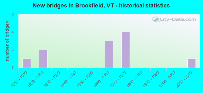
- New bridges - historical statistics
- 11910-1919
- 21920-1929
- 31960-1969
- 41970-1979
- 12010-2019
FCC Registered Antenna Towers:
6- Marin Fettman, 2382 Ridge Road (4bv0302a) (Lat: 44.010806 Lon: -72.616250), Type: 24.4, Overall height: 24.4 m, Registrant: T-Mobile Northeast LLC, Marin.Fettman@t-Mobile.Com, , Belle-vue, Phone: (425) 383-4000
- Dan Menser, 2382 Ridge Road (4bv0302a) (Lat: 44.010806 Lon: -72.616250), Type: 24.4, Overall height: 24.4 m, Registrant: T-Mobile Northeast LLC, Fccasrrequest@t-Mobile.Com, , Belle-vue, Phone: (425) 383-4000
- DAN MENSER, 2382 Ridge Road (4bv0302a) (Lat: 44.010806 Lon: -72.616250), Type: 24.4, Overall height: 24.4 m, Registrant: T-Mobile Northeast LLC, Fccasrrequest@t-Mobile.Com, , Belle-vue, Phone: (425) 383-4000
- CARISSA L BICK, 2382 Ridge Road (274392) (Lat: 44.010750 Lon: -72.616222), Type: 27.7, Overall height: 25.9 m, Registrant: American Towers, Inc., Bosto-n, Phone: (617) 585-7600
- CARISSA L BICK, 2382 Ridge Road (274392) (Lat: 44.010750 Lon: -72.616222), Type: 27.7, Overall height: 25.9 m, Registrant: American Towers, Inc., Bosto-n, Phone: (617) 585-7600
- CARISSA L BICK, 2382 Ridge Road (274392) (Lat: 44.010750 Lon: -72.616222), Type: 27.7, Overall height: 25.9 m, Registrant: American Towers, Inc., Wobur-n, Phone: (617) 585-7614
FCC Registered Broadcast Land Mobile Towers:
2- BROOKFIELD SCHOOL, 1728 Ridge Road (Lat: 44.016389 Lon: -72.606750), Type: Building, Structure height: 9 m, Call Sign: WQUS953,
Assigned Frequencies: 462.750 MHz, Grant Date: 10/02/2014, Expiration Date: 10/02/2024, Certifier: Mark Mckinstry, Registrant: Visiplex, Inc., 1287 North Barclay Boulevard, Buffalo Grove, IL 60089, Phone: (847) 229-0250, Fax: (847) 229-0259, Email:
- TOWN OFFICE, 40 Ralph Road (Lat: 44.043194 Lon: -72.602667), Type: Building, Structure height: 8 m, Overall height: 13 m, Call Sign: WQWJ728, Licensee ID: L00097919,
Assigned Frequencies: 156.142 MHz, Grant Date: 09/16/2015, Expiration Date: 09/16/2025, Certifier: John Benson, Registrant: City Of Brookfield, 40 Ralph Road, Brookfield, VT 05036, Phone: (802) 276-3352, Fax: (802) 276-3926, Email:
FCC Registered Amateur Radio Licenses:
12 (See the full list of FCC Registered Amateur Radio Licenses in Brookfield)FAA Registered Aircraft:
2- Aircraft: BOEING E75 (Category: Land, Seats: 2, Weight: Up to 12,499 Pounds, Speed: 93 mph), Engine: AMA/EXPR UNKNOWN ENG (Reciprocating)
N-Number: 1314N, N1314N, N-1314N, Serial Number: 75-5617, Year manufactured: 1942, Airworthiness Date: 08/13/1982, Certificate Issue Date: 09/04/2001
Registrant (Individual): Henry Buermann, 275 Woods Rd, Brookfield, VT 05036 - Aircraft: CESSNA 180 (Category: Land, Seats: 4, Weight: Up to 12,499 Pounds, Speed: 121 mph), Engine: CONT MOTOR O-470 SERIES (230 HP) (Reciprocating)
N-Number: 9762E, N9762E, N-9762E, Serial Number: 30799, Year manufactured: 1954, Airworthiness Date: 07/22/1957, Certificate Issue Date: 03/10/1993
Registrant (Individual): Hank Buermann, 275 Woods Rd, Brookfield, VT 05036
Deregistered: Cancel Date: 03/03/1971
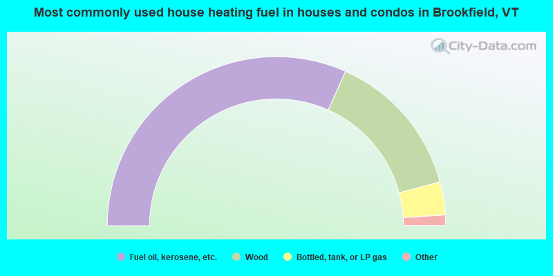
- 63.4%Fuel oil, kerosene, etc.
- 28.3%Wood
- 6.3%Bottled, tank, or LP gas
- 1.3%Electricity
- 0.8%Utility gas
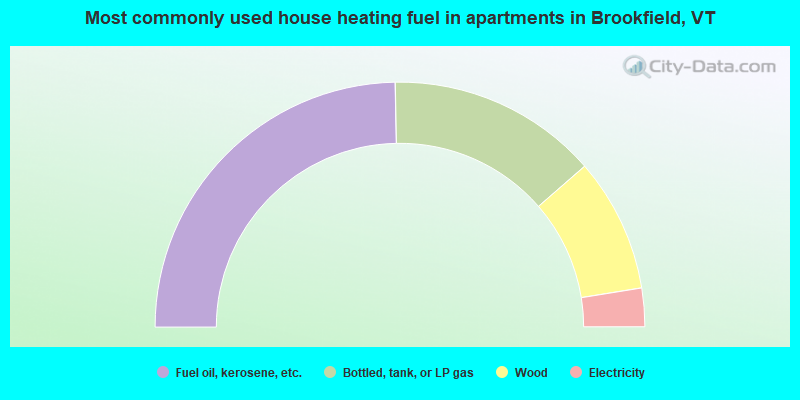
- 49.4%Fuel oil, kerosene, etc.
- 27.8%Bottled, tank, or LP gas
- 17.7%Wood
- 5.1%Electricity
Brookfield compared to Vermont state average:
- Unemployed percentage below state average.
- Black race population percentage significantly below state average.
- Hispanic race population percentage significantly below state average.
- Foreign-born population percentage significantly below state average.
- Renting percentage below state average.
- Length of stay since moving in significantly above state average.
- Number of rooms per house significantly below state average.
- House age significantly below state average.
- Number of college students below state average.
State forum archive:

|
Total of 8 patent applications in 2008-2024.