Bridge Statistics for Brookings, South Dakota (SD)
Condition, Traffic, Stress, Structural Evaluation, Project Costs
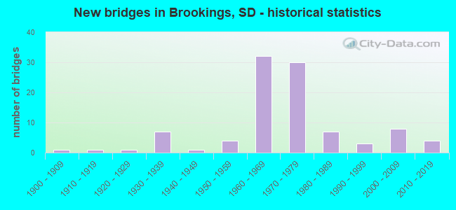
- New bridges - historical statistics
- 11900-1909
- 11910-1919
- 11920-1929
- 71930-1939
- 11940-1949
- 41950-1959
- 321960-1969
- 301970-1979
- 71980-1989
- 31990-1999
- 82000-2009
- 42010-2019
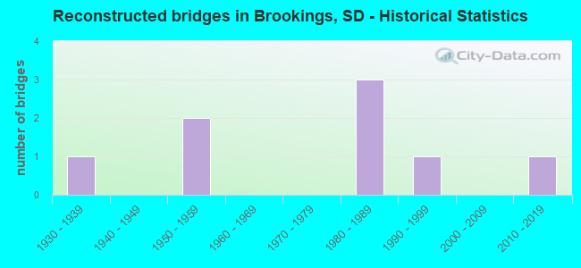
- Reconstructed bridges - Historical Statistics
- 11930-1939
- 01940-1949
- 21950-1959
- 01960-1969
- 01970-1979
- 31980-1989
- 11990-1999
- 02000-2009
- 12010-2019
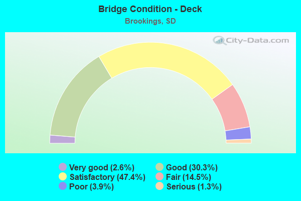
- Bridge Condition - Deck
- 2.6%Very good
- 30.3%Good
- 47.4%Satisfactory
- 14.5%Fair
- 3.9%Poor
- 1.3%Serious
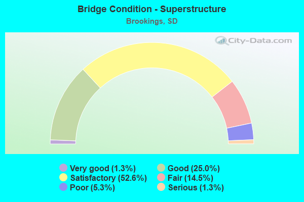
- Bridge Condition - Superstructure
- 1.3%Very good
- 25.0%Good
- 52.6%Satisfactory
- 14.5%Fair
- 5.3%Poor
- 1.3%Serious
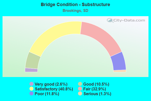
- Bridge Condition - Substructure
- 2.6%Very good
- 10.5%Good
- 40.8%Satisfactory
- 32.9%Fair
- 11.8%Poor
- 1.3%Serious
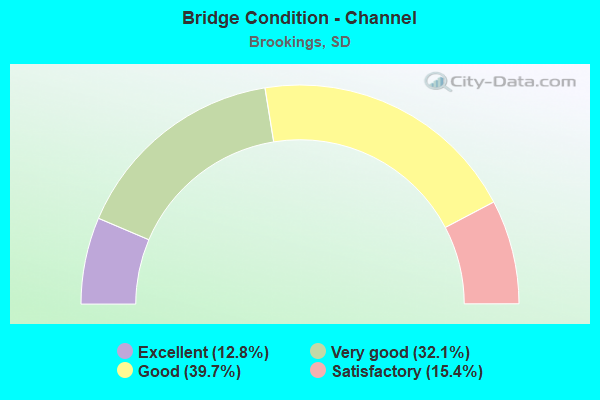
- Bridge Condition - Channel
- 12.8%Excellent
- 32.1%Very good
- 39.7%Good
- 15.4%Satisfactory
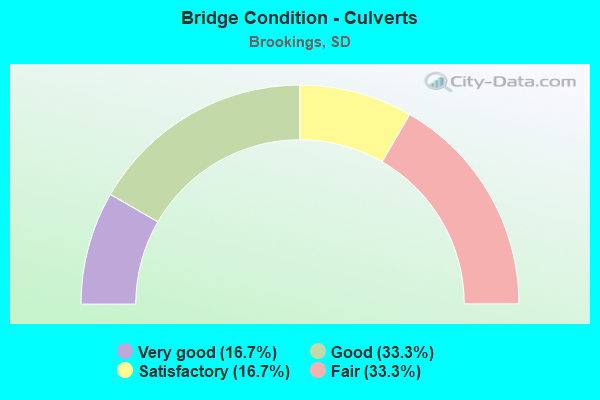
- Bridge Condition - Culverts
- 16.7%Very good
- 33.3%Good
- 16.7%Satisfactory
- 33.3%Fair
Find on map >> Show street view
Structure Number: 6193211, Location: 0.8 E I 29 INTERCH (Lat: 44.238994, Lng: -96.739872), Route carried "on" structure: State highway 324, Year Built: 1974, Status: Open, Structure Length: 6.37m (20.90ft), Average Daily Traffic: 1,407 (year 2021), Truck Traffic: 10%, Average Future Daily Traffic: 2,116 (year 2041), Design Load: HS 20, Features Intersected: MEDARY CK
Minimum Vertical Clearance: 30+ m (98+ ft), Kilometerpoint: 576.741, Lanes on structure: 2, Owner: State Highway Agency, Approaching Roadway Width: 9.8m (32.2ft), Material/Design: Concrete continuous, Design/Construction: Slab, Number Of Spans In Main Unit: 5, Length of Maximum Span: 13.0m (42.7ft), Curb-To-Curb Width: 9.8m (32.2ft), Out-to-Out Width: 10.6m (34.8ft)
Condition: Deck: Satisfactory, Superstructure: Satisfactory, Substructure: Satisfactory, Channel: Very good, Operating Rating: 83.8 metric tons, Method Used To Determine Operating Rating: Load Factor (LF), Inventory Rating: 50.2 metric tons, Method Used To Determine Inventory Rating: Load Factor (LF), Structural Evaluation: Equal to present minimum criteria, Deck Geometry: Somewhat better than minimum adequacy, Waterway Adequacy: Better than present minimum criteria, Approach Roadway Alignment: Equal to present desirable criteria, Designated Inspection Frequency: Every 24 months, Inspection Date: August 2021, Deck Structure Type: Concrete Cast-file-Place, Wearing Surface/Protective System: Wearing Surface: Epoxy Overlay, Membrane: Epoxy
Find on map >> Show street view
Structure Number: 619416, Location: 0.9 E I 29 INTERCH (Lat: 44.311558, Lng: -96.739542), Route carried "on" structure: US 14, Year Built: 1973, Status: Open, Structure Length: 2.24m (7.35ft), Average Daily Traffic: 4,937 (year 2021), Truck Traffic: 11%, Average Future Daily Traffic: 7,425 (year 2041), Design Load: HS 20, Features Intersected: WEST BR DEER CK
Minimum Vertical Clearance: 30+ m (98+ ft), Kilometerpoint: 680.012, Lanes on structure: 2, Base Highway Network: Yes, Owner: State Highway Agency, Approaching Roadway Width: 13.4m (44.0ft), Material/Design: Concrete continuous, Design/Construction: Slab, Number Of Spans In Main Unit: 3, Length of Maximum Span: 7.9m (25.9ft), Curb-To-Curb Width: 13.4m (44.0ft), Out-to-Out Width: 14.2m (46.6ft)
Condition: Deck: Satisfactory, Superstructure: Satisfactory, Substructure: Satisfactory, Channel: Excellent, Operating Rating: 59.4 metric tons, Method Used To Determine Operating Rating: Load Factor (LF), Inventory Rating: 35.7 metric tons, Method Used To Determine Inventory Rating: Load Factor (LF), Structural Evaluation: Equal to present minimum criteria, Deck Geometry: Better than present minimum criteria, Waterway Adequacy: Equal to present desirable criteria, Approach Roadway Alignment: Equal to present desirable criteria, Designated Inspection Frequency: Every 24 months, Inspection Date: August 2021, Deck Structure Type: Concrete Cast-file-Place, Wearing Surface/Protective System: Wearing Surface: Low Slump Concrete
Find on map >> Show street view
Structure Number: 6196156, Location: 1.4 E I 29 INTERCH (Lat: 44.316331, Lng: -96.736450), Route carried "on" structure: Bypass US 14, Year Built: 1967, Status: Open, Structure Length: 2.24m (7.35ft), Average Daily Traffic: 3,276 (year 2021), Truck Traffic: 10%, Average Future Daily Traffic: 4,927 (year 2041), Design Load: HS 20, Features Intersected: DEER CK
Minimum Vertical Clearance: 30+ m (98+ ft), Kilometerpoint: 680.527, Lanes on structure: 2, Owner: State Highway Agency, Approaching Roadway Width: 13.4m (44.0ft), Material/Design: Concrete continuous, Design/Construction: Slab, Number Of Spans In Main Unit: 3, Length of Maximum Span: 7.9m (25.9ft), Curb-To-Curb Width: 13.4m (44.0ft), Out-to-Out Width: 14.2m (46.6ft)
Condition: Deck: Satisfactory, Superstructure: Satisfactory, Substructure: Fair, Channel: Good, Operating Rating: 62.4 metric tons, Method Used To Determine Operating Rating: Load Factor (LF), Inventory Rating: 37.3 metric tons, Method Used To Determine Inventory Rating: Load Factor (LF), Structural Evaluation: Somewhat better than minimum adequacy, Deck Geometry: Better than present minimum criteria, Waterway Adequacy: Equal to present minimum criteria, Approach Roadway Alignment: Equal to present desirable criteria, Length Of Structure Improvement: 2.24m (7.35ft), Designated Inspection Frequency: Every 24 months, Inspection Date: August 2021, Bridge Improvement Cost: $30,000, Roadway Improvement Cost: $16,000, Total Project Cost: $80,000, Deck Structure Type: Concrete Cast-file-Place, Wearing Surface/Protective System: Wearing Surface: Low Slump Concrete, Membrane: Epoxy
Find on map >> Show street view
Structure Number: 620116, Location: 1.6 E I 29 INTERCH (Lat: 44.311508, Lng: -96.726433), Route carried "on" structure: US 14, Year Built: 1973, Status: Open, Structure Length: 3.23m (10.60ft), Average Daily Traffic: 4,609 (year 2021), Truck Traffic: 13%, Average Future Daily Traffic: 6,932 (year 2041), Design Load: HS 20, Features Intersected: CK
Minimum Vertical Clearance: 30+ m (98+ ft), Kilometerpoint: 681.605, Lanes on structure: 2, Owner: State Highway Agency, Approaching Roadway Width: 13.4m (44.0ft), Material/Design: Concrete continuous, Design/Construction: Slab, Number Of Spans In Main Unit: 3, Length of Maximum Span: 11.5m (37.7ft), Curb-To-Curb Width: 13.4m (44.0ft), Out-to-Out Width: 14.2m (46.6ft)
Condition: Deck: Satisfactory, Superstructure: Satisfactory, Substructure: Satisfactory, Channel: Good, Operating Rating: 61.7 metric tons, Method Used To Determine Operating Rating: Load Factor (LF), Inventory Rating: 36.9 metric tons, Method Used To Determine Inventory Rating: Load Factor (LF), Structural Evaluation: Equal to present minimum criteria, Deck Geometry: Better than present minimum criteria, Waterway Adequacy: Equal to present desirable criteria, Approach Roadway Alignment: Equal to present desirable criteria, Designated Inspection Frequency: Every 24 months, Inspection Date: August 2021, Deck Structure Type: Concrete Cast-file-Place, Wearing Surface/Protective System: Wearing Surface: Low Slump Concrete
Find on map >> Show street view
Structure Number: 6202201, Location: 3.1E & 4.1S BROOKINGS (Lat: 44.253200, Lng: -96.725358), Route carried "on" structure: County highway , Year Built: 1983, Status: Posted for load, Structure Length: 1.50m (4.92ft), Average Daily Traffic: 92 (year 2019), Truck Traffic: 2%, Average Future Daily Traffic: 92 (year 2032), Features Intersected: DEER CREEK, Facility Carried by Structure: 216TH STREET
Minimum Vertical Clearance: 30+ m (98+ ft), Kilometerpoint: 0.000, Lanes on structure: 2, Owner: County Highway Agency, Approaching Roadway Width: 5.2m (17.1ft), Material/Design: Steel, Design/Construction: Stringer/Multi-beam, Number Of Spans In Main Unit: 1, Length of Maximum Span: 14.7m (48.2ft), Curb-To-Curb Width: 7.3m (24.0ft), Out-to-Out Width: 7.4m (24.3ft)
Condition: Deck: Satisfactory, Superstructure: Fair, Substructure: Fair, Channel: Very good, Operating Rating: 21.5 metric tons, Method Used To Determine Operating Rating: Load Factor (LF), Inventory Rating: 12.9 metric tons, Method Used To Determine Inventory Rating: Load Factor (LF), Structural Evaluation: Meets minimum limits, Deck Geometry: Equal to present minimum criteria, Waterway Adequacy: Equal to present desirable criteria, Approach Roadway Alignment: Equal to present minimum criteria, Bridge Posting: Required (Relationship of Operating Rating to Maximum Legal Load: 20.0 - 29.9% below), Length Of Structure Improvement: 2.20m (7.22ft), Designated Inspection Frequency: Every 24 months, Inspection Date: August 2020, Bridge Improvement Cost: $356,000, Roadway Improvement Cost: $36,000, Total Project Cost: $743,000 ( Estimate for 2020), Deck Structure Type: Wood or Timber, Wearing Surface/Protective System: Wearing Surface: Wood or Timber
Find on map >> Show street view
Structure Number: 620311, Location: 5N & 3.3E BROOKINGS (Lat: 44.383675, Lng: -96.720139), Route carried "on" structure: County highway , Year Built: 1974, Status: Open, Structure Length: 3.05m (10.01ft), Average Daily Traffic: 120 (year 2019), Truck Traffic: 2%, Average Future Daily Traffic: 120 (year 2032), Design Load: HS 20, Features Intersected: SIX MILE CK, Facility Carried by Structure: 207TH STREET
Minimum Vertical Clearance: 30+ m (98+ ft), Kilometerpoint: 0.000, Lanes on structure: 2, Owner: County Highway Agency, Approaching Roadway Width: 9.1m (29.9ft), Material/Design: Concrete continuous, Design/Construction: Slab, Number Of Spans In Main Unit: 3, Length of Maximum Span: 11.4m (37.4ft), Curb-To-Curb Width: 9.2m (30.2ft), Out-to-Out Width: 10.0m (32.8ft)
Condition: Deck: Good, Superstructure: Good, Substructure: Satisfactory, Channel: Very good, Operating Rating: 53.0 metric tons, Method Used To Determine Operating Rating: Load Factor (LF), Inventory Rating: 31.7 metric tons, Method Used To Determine Inventory Rating: Load Factor (LF), Structural Evaluation: Equal to present minimum criteria, Deck Geometry: Equal to present minimum criteria, Waterway Adequacy: Superior to present desirable criteria, Approach Roadway Alignment: Equal to present desirable criteria, Length Of Structure Improvement: 3.87m (12.70ft), Designated Inspection Frequency: Every 24 months, Inspection Date: August 2020, Bridge Improvement Cost: $626,000, Roadway Improvement Cost: $63,000, Total Project Cost: $1,128,000 ( Estimate for 2020), Deck Structure Type: Concrete Cast-file-Place, Wearing Surface/Protective System: Wearing Surface: Bituminous
Find on map >> Show street view
Structure Number: 620416, Location: 1.9 E I 29 INTERCH (Lat: 44.311478, Lng: -96.720397), Route carried "on" structure: US 14, Year Built: 1973, Status: Open, Structure Length: 3.23m (10.60ft), Average Daily Traffic: 4,609 (year 2021), Truck Traffic: 13%, Average Future Daily Traffic: 6,932 (year 2041), Design Load: HS 20, Features Intersected: DEER CK
Minimum Vertical Clearance: 30+ m (98+ ft), Kilometerpoint: 682.120, Lanes on structure: 2, Owner: State Highway Agency, Approaching Roadway Width: 13.4m (44.0ft), Material/Design: Concrete continuous, Design/Construction: Slab, Number Of Spans In Main Unit: 3, Length of Maximum Span: 11.5m (37.7ft), Curb-To-Curb Width: 13.4m (44.0ft), Out-to-Out Width: 14.2m (46.6ft)
Condition: Deck: Satisfactory, Superstructure: Satisfactory, Substructure: Satisfactory, Channel: Good, Operating Rating: 63.4 metric tons, Method Used To Determine Operating Rating: Load Factor (LF), Inventory Rating: 38.0 metric tons, Method Used To Determine Inventory Rating: Load Factor (LF), Structural Evaluation: Equal to present minimum criteria, Deck Geometry: Better than present minimum criteria, Waterway Adequacy: Equal to present desirable criteria, Approach Roadway Alignment: Equal to present desirable criteria, Length Of Structure Improvement: 3.23m (10.60ft), Designated Inspection Frequency: Every 24 months, Inspection Date: August 2021, Bridge Improvement Cost: $35,000, Roadway Improvement Cost: $16,000, Total Project Cost: $86,000, Deck Structure Type: Concrete Cast-file-Place, Wearing Surface/Protective System: Wearing Surface: Low Slump Concrete
Find on map >> Show street view
Structure Number: 620915, Location: 3.9E & 1N BROOKINGS (Lat: 44.325953, Lng: -96.709717), Route carried "on" structure: County highway , Year Built: 2015, Status: Open, Structure Length: 2.00m (6.56ft), Average Daily Traffic: 77 (year 2019), Truck Traffic: 4%, Average Future Daily Traffic: 105 (year 2032), Design Load: HL 93, Features Intersected: DEER CK, Facility Carried by Structure: 211TH STREET
Minimum Vertical Clearance: 30+ m (98+ ft), Kilometerpoint: 0.000, Lanes on structure: 2, Owner: County Highway Agency, Approaching Roadway Width: 7.0m (23.0ft), Material/Design: Prestressed concrete, Design/Construction: Tee Beam, Number Of Spans In Main Unit: 1, Length of Maximum Span: 19.5m (64.0ft), Curb-To-Curb Width: 8.7m (28.5ft), Out-to-Out Width: 9.3m (30.5ft)
Condition: Deck: Very good, Superstructure: Very good, Substructure: Very good, Channel: Excellent, Operating Rating: 32.7 metric tons, Method Used To Determine Operating Rating: Field evaluation and documented engineering judgment, Inventory Rating: 19.6 metric tons, Method Used To Determine Inventory Rating: Field evaluation and documented engineering judgment, Structural Evaluation: Somewhat better than minimum adequacy, Deck Geometry: Better than present minimum criteria, Waterway Adequacy: Superior to present desirable criteria, Approach Roadway Alignment: Superior to present desirable criteria, Length Of Structure Improvement: 2.75m (9.02ft), Designated Inspection Frequency: Every 24 months, Inspection Date: August 2020, Bridge Improvement Cost: $444,000, Roadway Improvement Cost: $44,000, Total Project Cost: $870,000 ( Estimate for 2020), Deck Structure Type: Concrete Precast Panels, Wearing Surface/Protective System: Wearing Surface: Monolithic Concrete
Find on map >> Show street view
Structure Number: 6210121, Location: 2.9N & 3W BUSHNELL (Lat: 44.368889, Lng: -96.707161), Route carried "on" structure: County highway , Year Built: 1930, Status: Posted for load, Structure Length: 1.31m (4.30ft), Average Daily Traffic: 92 (year 2019), Truck Traffic: 2%, Average Future Daily Traffic: 92 (year 2032), Features Intersected: CK, Facility Carried by Structure: 475TH AVENUE
Minimum Vertical Clearance: 30+ m (98+ ft), Kilometerpoint: 0.000, Lanes on structure: 2, Owner: County Highway Agency, Approaching Roadway Width: 5.8m (19.0ft), Material/Design: Steel, Design/Construction: Truss - Thru, Number Of Spans In Main Unit: 1, Length of Maximum Span: 12.3m (40.4ft), Curb-To-Curb Width: 5.2m (17.1ft), Out-to-Out Width: 5.5m (18.0ft)
Condition: Deck: Fair, Superstructure: Satisfactory, Substructure: Fair, Channel: Very good, Operating Rating: 20.4 metric tons, Method Used To Determine Operating Rating: Load Factor (LF), Inventory Rating: 9.3 metric tons, Method Used To Determine Inventory Rating: Load Factor (LF), Structural Evaluation: High priority of replacement, Deck Geometry: High priority of corrective action, Waterway Adequacy: Equal to present minimum criteria, Approach Roadway Alignment: Somewhat better than minimum adequacy, Bridge Posting: Required (Relationship of Operating Rating to Maximum Legal Load: 20.0 - 29.9% below), Length Of Structure Improvement: 1.98m (6.50ft), Designated Inspection Frequency: Every 24 months, Critical Feature Inspection Frequency: Every 24 months, Inspection Date: August 2020, Critical Feature Inspection Date: August 2020, Bridge Improvement Cost: $321,000, Roadway Improvement Cost: $32,000, Total Project Cost: $689,000 ( Estimate for 2020), Deck Structure Type: Concrete Cast-file-Place, Wearing Surface/Protective System: Wearing Surface: Gravel
Find on map >> Show street view
Structure Number: 615415, Location: 1N 1.6W BROOKINGS (Lat: 44.325783, Lng: -96.822258), Route carried "under" structure: Bypass US 14, Year Built: 1970, Structure Length: 0. m, Average Daily Traffic: 7,718 (year 2020), Truck Traffic: 7%, Features Intersected: US014 B
Minimum Vertical Clearance: 5.11m (16.77ft), Kilometerpoint: 673.076, Lanes on structure: 2, Lanes under structure: 4, Material/Design: Steel continuous, Design/Construction: Stringer/Multi-beam, Length of Maximum Span: 31.1m (102.0ft)
Find on map >> Show street view
Structure Number: 6167164, Location: 6TH AVENUE (Lat: 44.306042, Lng: -96.795297), Route carried "under" structure: City street , Year Built: 1936, Structure Length: 0. m, Average Daily Traffic: 330 (year 1997), Truck Traffic: 1%, Features Intersected: 6TH AVENUE, Facility Carried by Structure: CP/DM&E RR
Minimum Vertical Clearance: 4.19m (13.75ft), Kilometerpoint: 0.000, Lanes under structure: 2, Material/Design: Steel, Design/Construction: Stringer/Multi-beam, Length of Maximum Span: 11.0m (36.1ft)
Find on map >> Show street view
Structure Number: 6184169, Location: 0.9 S US 14 INTERCH (Lat: 44.298406, Lng: -96.758794), Route carried "under" structure: City street , Year Built: 1966, Structure Length: 0. m, Average Daily Traffic: 20 (year 2020), Features Intersected: 8TH ST S, CP/DM&E RR, Facility Carried by Structure: I029 S
Minimum Vertical Clearance: 5.46m (17.91ft), Kilometerpoint: 0.000, Lanes on structure: 2, Lanes under structure: 1, Material/Design: Prestressed concrete continuous, Design/Construction: Stringer/Multi-beam, Length of Maximum Span: 15.4m (50.5ft)
Find on map >> Show street view
Structure Number: 618511, Location: 3 S SD 30 INTERCH (Lat: 44.383764, Lng: -96.756872), Route carried "under" structure: Interstate 29, Year Built: 1970, Structure Length: 0. m, Average Daily Traffic: 9,960 (year 2020), Truck Traffic: 16%, Features Intersected: I029, Facility Carried by Structure: 207 ST
Minimum Vertical Clearance: 5.18m (16.99ft), Kilometerpoint: 221.752, Lanes on structure: 2, Lanes under structure: 4, Material/Design: Steel continuous, Design/Construction: Stringer/Multi-beam, Length of Maximum Span: 32.0m (105.0ft)
Find on map >> Show street view
Structure Number: 618513, Location: 2 N US14 BY PASS (Lat: 44.355069, Lng: -96.757336), Route carried "under" structure: Interstate 29, Year Built: 1970, Structure Length: 0. m, Average Daily Traffic: 9,960 (year 2020), Truck Traffic: 16%, Features Intersected: I029, Facility Carried by Structure: 209 ST
Minimum Vertical Clearance: 5.41m (17.75ft), Kilometerpoint: 218.565, Lanes on structure: 2, Lanes under structure: 4, Material/Design: Steel continuous, Design/Construction: Stringer/Multi-beam, Length of Maximum Span: 32.0m (105.0ft)
Find on map >> Show street view
Structure Number: 618515, Location: US14 BY-PASS INTERCHANGE (Lat: 44.325803, Lng: -96.757883), Route carried "under" structure: Interstate 29, Year Built: 1966, Structure Length: 0. m, Average Daily Traffic: 9,960 (year 2020), Truck Traffic: 16%, Features Intersected: I029, Facility Carried by Structure: US014 B
Minimum Vertical Clearance: 5.23m (17.16ft), Kilometerpoint: 215.314, Lanes on structure: 2, Lanes under structure: 4, Material/Design: Steel continuous, Design/Construction: Stringer/Multi-beam, Length of Maximum Span: 21.3m (69.9ft)
Find on map >> Show street view
Structure Number: 6185159, Location: US 14 & I 29 INTERCHANGE (Lat: 44.311681, Lng: -96.758108), Route carried "under" structure: Interstate 29, Year Built: 2017, Structure Length: 0. m, Average Daily Traffic: 10,990 (year 2020), Truck Traffic: 15%, Features Intersected: I029, Facility Carried by Structure: US014
Minimum Vertical Clearance: 5.46m (17.91ft), Kilometerpoint: 213.689, Lanes on structure: 2, Lanes under structure: 4, Material/Design: Prestressed concrete, Design/Construction: Stringer/Multi-beam, Length of Maximum Span: 38.4m (126.0ft)
Find on map >> Show street view
Structure Number: 6185169, Location: 0.9 S US 14 INTERCH (Lat: 44.298331, Lng: -96.758453), Route carried "under" structure: City street , Year Built: 1966, Structure Length: 0. m, Average Daily Traffic: 20 (year 2020), Features Intersected: 8TH ST S, CP/DM&E RR, Facility Carried by Structure: I029 N
Minimum Vertical Clearance: 5.69m (18.67ft), Kilometerpoint: 0.000, Lanes on structure: 2, Lanes under structure: 1, Material/Design: Prestressed concrete continuous, Design/Construction: Stringer/Multi-beam, Length of Maximum Span: 15.4m (50.5ft)
Find on map >> Show street view
Structure Number: 618519, Location: 3 S US 14 INTERCH (Lat: 44.268103, Lng: -96.757433), Route carried "under" structure: Interstate 29, Year Built: 1966, Structure Length: 0. m, Average Daily Traffic: 12,240 (year 2020), Truck Traffic: 20%, Features Intersected: I029, Facility Carried by Structure: 215 ST
Minimum Vertical Clearance: 5.16m (16.93ft), Kilometerpoint: 208.893, Lanes on structure: 2, Lanes under structure: 4, Material/Design: Prestressed concrete continuous, Design/Construction: Stringer/Multi-beam, Length of Maximum Span: 21.3m (69.9ft)
Find on map >> Show street view
Structure Number: 618521, Location: SD 324 INTERCHANGE (Lat: 44.239078, Lng: -96.756697), Route carried "under" structure: Interstate 29, Year Built: 1966, Structure Length: 0. m, Average Daily Traffic: 12,240 (year 2020), Truck Traffic: 20%, Features Intersected: I029, Facility Carried by Structure: SD324
Minimum Vertical Clearance: 5.16m (16.93ft), Kilometerpoint: 205.690, Lanes on structure: 2, Lanes under structure: 4, Material/Design: Steel continuous, Design/Construction: Stringer/Multi-beam, Length of Maximum Span: 21.3m (69.9ft)
Find on map >> Show street view
Structure Number: 618523, Location: 1 N MOODY CO LINE (Lat: 44.210122, Lng: -96.756833), Route carried "under" structure: Interstate 29, Year Built: 1966, Structure Length: 0. m, Average Daily Traffic: 12,630 (year 2020), Truck Traffic: 18%, Features Intersected: I029, Facility Carried by Structure: 219 ST
Minimum Vertical Clearance: 5.23m (17.16ft), Kilometerpoint: 202.455, Lanes on structure: 2, Lanes under structure: 4, Material/Design: Steel continuous, Design/Construction: Stringer/Multi-beam, Length of Maximum Span: 21.3m (69.9ft)