Bridge Statistics for Brooklyn Park, Minnesota (MN)
Condition, Traffic, Stress, Structural Evaluation, Project Costs
- National Bridge Inventory (NBI) Statistics
- 78Number of bridges
- 1,352ft / 412mTotal length
- $840,000,000Total costs
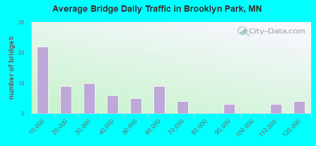
- 2,686,360Total average daily traffic
- 116,143Total average daily truck traffic
- National Bridge Inventory (NBI) Registered Bridges for Brooklyn Park
- No street view available for this location
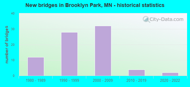
- New bridges - historical statistics
- 121980-1989
- 281990-1999
- 322000-2009
- 42010-2019
- 22020-2022
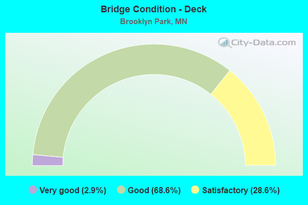
- Bridge Condition - Deck
- 2.9%Very good
- 68.6%Good
- 28.6%Satisfactory
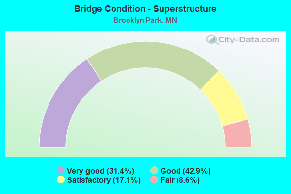
- Bridge Condition - Superstructure
- 31.4%Very good
- 42.9%Good
- 17.1%Satisfactory
- 8.6%Fair
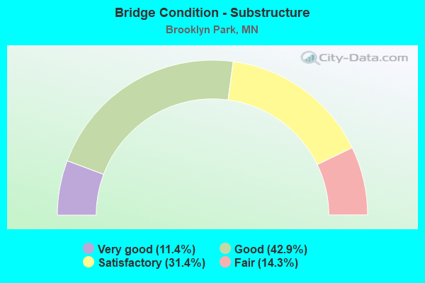
- Bridge Condition - Substructure
- 11.4%Very good
- 42.9%Good
- 31.4%Satisfactory
- 14.3%Fair
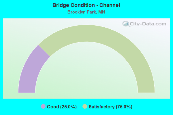
- Bridge Condition - Channel
- 25.0%Good
- 75.0%Satisfactory
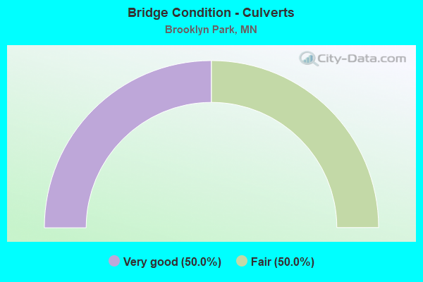
- Bridge Condition - Culverts
- 50.0%Very good
- 50.0%Fair
Find on map >> Show street view
Structure Number: 27298, Location: 0.4 MI S OF JCT TH 610 (Lat: 45.123511, Lng: -93.389122), Route carried "under" structure: US 169, Year Built: 2013, Structure Length: 0. m, Average Daily Traffic: 64,219 (year 2019), Truck Traffic: 4%, Features Intersected: TH 169; RAMPS, Facility Carried by Structure: CSAH 30
Minimum Vertical Clearance: 5.70m (18.70ft), Kilometerpoint: 0.000, Lanes under structure: 4, Material/Design: Prestressed concrete, Design/Construction: Stringer/Multi-beam, Length of Maximum Span: 40.8m (133.9ft)
Find on map >> Show street view
Structure Number: 27298, Location: 0.4 MI S OF JCT TH 610 (Lat: 45.123511, Lng: -93.389122), Route carried "under" structure: Ramp US 7402, Year Built: 2013, Structure Length: 0. m, Average Daily Traffic: 1 (year 2013), Features Intersected: TH 169; RAMPS, Facility Carried by Structure: CSAH 30
Minimum Vertical Clearance: 5.15m (16.90ft), Kilometerpoint: 0.000, Lanes under structure: 1, Material/Design: Prestressed concrete, Design/Construction: Stringer/Multi-beam, Length of Maximum Span: 40.8m (133.9ft)
Find on map >> Show street view
Structure Number: 27298, Location: 0.4 MI S OF JCT TH 610 (Lat: 45.123511, Lng: -93.389122), Route carried "under" structure: Ramp US 7401, Year Built: 2013, Structure Length: 0. m, Average Daily Traffic: 1 (year 2013), Features Intersected: TH 169; RAMPS, Facility Carried by Structure: CSAH 30
Minimum Vertical Clearance: 5.70m (18.70ft), Kilometerpoint: 0.000, Lanes under structure: 1, Material/Design: Prestressed concrete, Design/Construction: Stringer/Multi-beam, Length of Maximum Span: 40.8m (133.9ft)
Find on map >> Show street view
Structure Number: 2763, Location: 0.8 MI N OF JCT TH 94 (Lat: 45.094647, Lng: -93.402375), Route carried "under" structure: US 169, Year Built: 1984, Structure Length: 0. m, Average Daily Traffic: 88,000 (year 2019), Truck Traffic: 4%, Features Intersected: US 169, Facility Carried by Structure: CSAH 130
Minimum Vertical Clearance: 4.66m (15.29ft), Kilometerpoint: 0.000, Lanes on structure: 4, Lanes under structure: 4, Material/Design: Prestressed concrete, Design/Construction: Stringer/Multi-beam, Length of Maximum Span: 30.6m (100.4ft)
Find on map >> Show street view
Structure Number: 27662, Location: 2.4 MI N OF JCT TH 152 (Lat: 45.141044, Lng: -93.392150), Route carried "under" structure: US 169, Year Built: 1984, Structure Length: 0. m, Average Daily Traffic: 47,000 (year 2019), Truck Traffic: 3%, Features Intersected: US 169, Facility Carried by Structure: PEDESTRIAN
Minimum Vertical Clearance: 5.27m (17.29ft), Kilometerpoint: 0.000, Lanes on structure: 2, Lanes under structure: 2, Material/Design: Wood or Timber, Design/Construction: Truss - Thru, Length of Maximum Span: 38.1m (125.0ft)
Find on map >> Show street view
Structure Number: 27685, Location: 3.2 MI N OF JCT TH 694 (Lat: 45.109242, Lng: -93.301269), Route carried "under" structure: State highway 252, Year Built: 2003, Structure Length: 0. m, Average Daily Traffic: 58,000 (year 2019), Truck Traffic: 2%, Features Intersected: TH 252, Facility Carried by Structure: PEDESTRIAN
Minimum Vertical Clearance: 6.10m (20.01ft), Lanes on structure: 5, Lanes under structure: 5, Material/Design: Steel continuous, Design/Construction: Stringer/Multi-beam, Length of Maximum Span: 36.0m (118.1ft)
Find on map >> Show street view
Structure Number: 27707, Location: 0.5 MI E OF JCT TH 169 (Lat: 45.079933, Lng: -93.392150), Route carried "under" structure: Interstate 94, Year Built: 1984, Structure Length: 0. m, Average Daily Traffic: 114,000 (year 2019), Truck Traffic: 6%, Features Intersected: I 94; WB ON RAMP, Facility Carried by Structure: MSAS 104
Minimum Vertical Clearance: 5.00m (16.40ft), Kilometerpoint: 0.000, Lanes on structure: 4, Lanes under structure: 4, Material/Design: Prestressed concrete, Design/Construction: Stringer/Multi-beam, Length of Maximum Span: 32.0m (105.0ft)
Find on map >> Show street view
Structure Number: 27707, Location: 0.5 MI E OF JCT TH 169 (Lat: 45.079933, Lng: -93.392150), Route carried "under" structure: Ramp Interstate 5653, Year Built: 1984, Structure Length: 0. m, Average Daily Traffic: 1,400 (year 1994), Features Intersected: I 94; WB ON RAMP, Facility Carried by Structure: MSAS 104
Minimum Vertical Clearance: 5.12m (16.80ft), Kilometerpoint: 0.000, Lanes on structure: 4, Lanes under structure: 1, Material/Design: Prestressed concrete, Design/Construction: Stringer/Multi-beam, Length of Maximum Span: 32.0m (105.0ft)
Find on map >> Show street view
Structure Number: 27R18, Location: 1.7 MI S OF JCT 169; 610 (Lat: 45.106014, Lng: -93.393508), Route carried "under" structure: Ramp US 7028, Year Built: 2008, Structure Length: 0. m, Average Daily Traffic: 1 (year 2009), Features Intersected: CSAH 81, RAMP; BNSF RR, Facility Carried by Structure: US 169
Minimum Vertical Clearance: 5.91m (19.39ft), Kilometerpoint: 0.000, Lanes on structure: 3, Lanes under structure: 1, Material/Design: Steel continuous, Design/Construction: Stringer/Multi-beam, Length of Maximum Span: 50.6m (166.0ft)
Find on map >> Show street view
Structure Number: 27R18, Location: 1.7 MI S OF JCT 169; 610 (Lat: 45.106014, Lng: -93.393508), Route carried "under" structure: County highway 81, Year Built: 2008, Structure Length: 0. m, Average Daily Traffic: 27,500 (year 2004), Features Intersected: CSAH 81, RAMP; BNSF RR, Facility Carried by Structure: US 169
Minimum Vertical Clearance: 6.65m (21.82ft), Kilometerpoint: 0.000, Lanes on structure: 3, Lanes under structure: 4, Material/Design: Steel continuous, Design/Construction: Stringer/Multi-beam, Length of Maximum Span: 50.6m (166.0ft)
Find on map >> Show street view
Structure Number: 27R19, Location: 1.7 MI S OF JCT 169; 610 (Lat: 45.105842, Lng: -93.393264), Route carried "under" structure: County highway 81, Year Built: 2008, Structure Length: 0. m, Average Daily Traffic: 27,900 (year 2009), Features Intersected: CSAH 81, RAMP; BNSF RR, Facility Carried by Structure: US 169
Minimum Vertical Clearance: 8.05m (26.41ft), Kilometerpoint: 0.000, Lanes on structure: 2, Lanes under structure: 4, Material/Design: Steel continuous, Design/Construction: Stringer/Multi-beam, Length of Maximum Span: 48.8m (160.1ft)
Find on map >> Show street view
Structure Number: 27R19, Location: 1.7 MI S OF JCT 169; 610 (Lat: 45.105842, Lng: -93.393264), Route carried "under" structure: Ramp US 7028, Year Built: 2008, Structure Length: 0. m, Average Daily Traffic: 1 (year 2009), Features Intersected: CSAH 81, RAMP; BNSF RR, Facility Carried by Structure: US 169
Minimum Vertical Clearance: 7.93m (26.02ft), Kilometerpoint: 0.000, Lanes on structure: 2, Lanes under structure: 1, Material/Design: Steel continuous, Design/Construction: Stringer/Multi-beam, Length of Maximum Span: 48.8m (160.1ft)
Find on map >> Show street view
Structure Number: 27R2, Location: 1.5 MI S OF JCT 169; 610 (Lat: 45.108892, Lng: -93.391792), Route carried "under" structure: County highway 109, Year Built: 2008, Structure Length: 0. m, Average Daily Traffic: 15,100 (year 2009), Truck Traffic: 6%, Features Intersected: 85 AVE N, Facility Carried by Structure: US 169
Minimum Vertical Clearance: 5.00m (16.40ft), Kilometerpoint: 0.000, Lanes on structure: 3, Lanes under structure: 4, Material/Design: Prestressed concrete, Design/Construction: Stringer/Multi-beam, Length of Maximum Span: 25.7m (84.3ft)
Find on map >> Show street view
Structure Number: 27R21, Location: 1.5 MI S OF JCT 169; 610 (Lat: 45.108994, Lng: -93.391425), Route carried "under" structure: County highway 109, Year Built: 2008, Structure Length: 0. m, Average Daily Traffic: 15,100 (year 2009), Truck Traffic: 6%, Features Intersected: 85 AVE N, Facility Carried by Structure: US 169
Minimum Vertical Clearance: 6.28m (20.60ft), Kilometerpoint: 0.000, Lanes on structure: 2, Lanes under structure: 4, Material/Design: Prestressed concrete, Design/Construction: Stringer/Multi-beam, Length of Maximum Span: 25.7m (84.3ft)
Find on map >> Show street view
Structure Number: 27R22, Location: 1.55 MI S OF JCT 169; 61 (Lat: 45.109036, Lng: -93.393569), Route carried "under" structure: County highway 109, Year Built: 2008, Structure Length: 0. m, Average Daily Traffic: 15,100 (year 2009), Truck Traffic: 6%, Features Intersected: CSAH 109; CSAH 81, Facility Carried by Structure: CON 7028
Minimum Vertical Clearance: 4.97m (16.31ft), Kilometerpoint: 0.000, Lanes on structure: 1, Lanes under structure: 5, Material/Design: Steel continuous, Design/Construction: Stringer/Multi-beam, Length of Maximum Span: 53.3m (174.9ft)
Find on map >> Show street view
Structure Number: 27R22, Location: 1.55 MI S OF JCT 169; 61 (Lat: 45.109036, Lng: -93.393569), Route carried "under" structure: County highway 81, Year Built: 2008, Structure Length: 0. m, Average Daily Traffic: 27,900 (year 2009), Truck Traffic: 11%, Features Intersected: CSAH 109; CSAH 81, Facility Carried by Structure: CON 7028
Minimum Vertical Clearance: 5.30m (17.39ft), Kilometerpoint: 0.000, Lanes on structure: 1, Lanes under structure: 6, Material/Design: Steel continuous, Design/Construction: Stringer/Multi-beam, Length of Maximum Span: 53.3m (174.9ft)
Find on map >> Show street view
Structure Number: 27R23, Location: 1.7 MI S OF JCT 169; 610 (Lat: 45.105675, Lng: -93.392906), Route carried "under" structure: Ramp US 6237, Year Built: 2008, Structure Length: 0. m, Average Daily Traffic: 1 (year 2009), Features Intersected: CSAH 81; BNSF RR, Facility Carried by Structure: CON 6992
Minimum Vertical Clearance: 5.30m (17.39ft), Kilometerpoint: 0.000, Lanes on structure: 1, Lanes under structure: 1, Material/Design: Steel continuous, Design/Construction: Stringer/Multi-beam, Length of Maximum Span: 44.0m (144.4ft)
Find on map >> Show street view
Structure Number: 27R23, Location: 1.7 MI S OF JCT 169; 610 (Lat: 45.105675, Lng: -93.392906), Route carried "under" structure: County highway 81, Year Built: 2008, Structure Length: 0. m, Average Daily Traffic: 27,900 (year 2009), Truck Traffic: 11%, Features Intersected: CSAH 81; BNSF RR, Facility Carried by Structure: CON 6992
Minimum Vertical Clearance: 6.49m (21.29ft), Kilometerpoint: 0.000, Lanes on structure: 1, Lanes under structure: 66, Material/Design: Steel continuous, Design/Construction: Stringer/Multi-beam, Length of Maximum Span: 44.0m (144.4ft)
Find on map >> Show street view
Structure Number: 27R23, Location: 1.7 MI S OF JCT 169; 610 (Lat: 45.105675, Lng: -93.392906), Route carried "under" structure: Ramp US 7028, Year Built: 2008, Structure Length: 0. m, Average Daily Traffic: 1 (year 2009), Features Intersected: CSAH 81; BNSF RR, Facility Carried by Structure: CON 6992
Minimum Vertical Clearance: 7.07m (23.20ft), Kilometerpoint: 0.000, Lanes on structure: 1, Lanes under structure: 1, Material/Design: Steel continuous, Design/Construction: Stringer/Multi-beam, Length of Maximum Span: 44.0m (144.4ft)
Find on map >> Show street view
Structure Number: 27R24, Location: 1.7 MI S OF JCT 169; 610 (Lat: 45.106358, Lng: -93.393464), Route carried "under" structure: Ramp Interstate 7028, Year Built: 2008, Structure Length: 0. m, Average Daily Traffic: 1 (year 2009), Features Intersected: CSAH 81, BNSF RR, RAMP, Facility Carried by Structure: CON 6994
Minimum Vertical Clearance: 5.06m (16.60ft), Kilometerpoint: 0.000, Lanes on structure: 1, Lanes under structure: 1, Material/Design: Steel continuous, Design/Construction: Stringer/Multi-beam, Length of Maximum Span: 52.2m (171.3ft)
Find on map >> Show street view
Structure Number: 27R24, Location: 1.7 MI S OF JCT 169; 610 (Lat: 45.106358, Lng: -93.393464), Route carried "under" structure: County highway 81, Year Built: 2008, Structure Length: 0. m, Average Daily Traffic: 27,900 (year 2009), Truck Traffic: 6%, Features Intersected: CSAH 81, BNSF RR, RAMP, Facility Carried by Structure: CON 6994
Minimum Vertical Clearance: 4.94m (16.21ft), Kilometerpoint: 0.000, Lanes on structure: 1, Lanes under structure: 4, Material/Design: Steel continuous, Design/Construction: Stringer/Multi-beam, Length of Maximum Span: 52.2m (171.3ft)
Find on map >> Show street view
Structure Number: 27V01, Location: AT THE JCT OF TH 169; 94 (Lat: 45.083108, Lng: -93.402322), Route carried "under" structure: Interstate 94, Year Built: 1996, Structure Length: 0. m, Average Daily Traffic: 117,000 (year 2019), Truck Traffic: 6%, Features Intersected: I 94, Facility Carried by Structure: US 169
Minimum Vertical Clearance: 5.15m (16.90ft), Kilometerpoint: 0.000, Lanes on structure: 3, Lanes under structure: 4, Material/Design: Prestressed concrete, Design/Construction: Stringer/Multi-beam, Length of Maximum Span: 34.5m (113.2ft)
Find on map >> Show street view
Structure Number: 27V02, Location: AT THE JCT OF TH 169; 94 (Lat: 45.083008, Lng: -93.402069), Route carried "under" structure: Interstate 94, Year Built: 1996, Structure Length: 0. m, Average Daily Traffic: 117,000 (year 2019), Truck Traffic: 6%, Features Intersected: I 94, Facility Carried by Structure: US 169
Minimum Vertical Clearance: 5.27m (17.29ft), Kilometerpoint: 0.000, Lanes on structure: 3, Lanes under structure: 4, Material/Design: Prestressed concrete, Design/Construction: Stringer/Multi-beam, Length of Maximum Span: 34.5m (113.2ft)
Find on map >> Show street view
Structure Number: 27V39, Location: 1.5 mi E of jct TH 169 (Lat: 45.078258, Lng: -93.376267), Route carried "under" structure: County highway 8, Year Built: 2001, Structure Length: 0. m, Average Daily Traffic: 3,350 (year 2005), Features Intersected: W Broadway (CSAH 8), Facility Carried by Structure: I 94
Minimum Vertical Clearance: 5.06m (16.60ft), Kilometerpoint: 0.000, Lanes on structure: 4, Lanes under structure: 2, Material/Design: Prestressed concrete, Design/Construction: Stringer/Multi-beam, Length of Maximum Span: 32.9m (107.9ft)
Find on map >> Show street view
Structure Number: 27V4, Location: 1.5 mi E jct TH 169 (Lat: 45.078092, Lng: -93.376258), Route carried "under" structure: County highway 8, Year Built: 2001, Structure Length: 0. m, Average Daily Traffic: 3,350 (year 2005), Features Intersected: W Broadway (CSAH8), Facility Carried by Structure: I 94
Minimum Vertical Clearance: 4.97m (16.31ft), Kilometerpoint: 0.000, Lanes on structure: 3, Lanes under structure: 2, Material/Design: Prestressed concrete, Design/Construction: Stringer/Multi-beam, Length of Maximum Span: 32.8m (107.6ft)
Find on map >> Show street view
Structure Number: 27V43, Location: 1.4 MI E OF JCT TH 169 (Lat: 45.078206, Lng: -93.373833), Route carried "under" structure: County highway 81, Year Built: 2001, Structure Length: 0. m, Average Daily Traffic: 27,500 (year 2005), Features Intersected: CSAH 81; BNSF RR, Facility Carried by Structure: I 94
Minimum Vertical Clearance: 7.44m (24.41ft), Kilometerpoint: 0.000, Lanes on structure: 4, Lanes under structure: 4, Material/Design: Prestressed concrete, Design/Construction: Stringer/Multi-beam, Length of Maximum Span: 35.5m (116.5ft)
Find on map >> Show street view
Structure Number: 27V44, Location: 1.4 MI E OF jct TH 169 (Lat: 45.077994, Lng: -93.373794), Route carried "under" structure: County highway 81, Year Built: 2001, Structure Length: 0. m, Average Daily Traffic: 27,500 (year 2005), Features Intersected: CSAH 81; BNSF RR, Facility Carried by Structure: I 94
Minimum Vertical Clearance: 7.44m (24.41ft), Kilometerpoint: 0.000, Lanes on structure: 4, Lanes under structure: 4, Material/Design: Prestressed concrete, Design/Construction: Stringer/Multi-beam, Length of Maximum Span: 35.5m (116.5ft)
Find on map >> Show street view
Structure Number: 27V46, Location: 2.3 MIE OF JCT TH 169 (Lat: 45.076183, Lng: -93.355689), Route carried "under" structure: Interstate 94, Year Built: 2002, Structure Length: 0. m, Average Daily Traffic: 116,000 (year 2019), Truck Traffic: 6%, Features Intersected: I 94, Facility Carried by Structure: MSAS 102
Minimum Vertical Clearance: 5.46m (17.91ft), Kilometerpoint: 0.000, Lanes on structure: 2, Lanes under structure: 6, Material/Design: Prestressed concrete, Design/Construction: Stringer/Multi-beam, Length of Maximum Span: 32.1m (105.3ft)
Find on map >> Show street view
Structure Number: 27W46, Location: 0.5 MI N OF JCT TH 610 (Lat: 45.137689, Lng: -93.392250), Route carried "under" structure: US 169, Year Built: 2020, Structure Length: 0. m, Average Daily Traffic: 47,000 (year 2019), Truck Traffic: 3%, Features Intersected: TH 169, Facility Carried by Structure: MSAS 129
Minimum Vertical Clearance: 5.15m (16.90ft), Kilometerpoint: 0.000, Lanes under structure: 6, Material/Design: Prestressed concrete, Design/Construction: Stringer/Multi-beam, Length of Maximum Span: 26.5m (86.9ft)