Bridge Statistics for Broomall, Pennsylvania (PA)
Condition, Traffic, Stress, Structural Evaluation, Project Costs
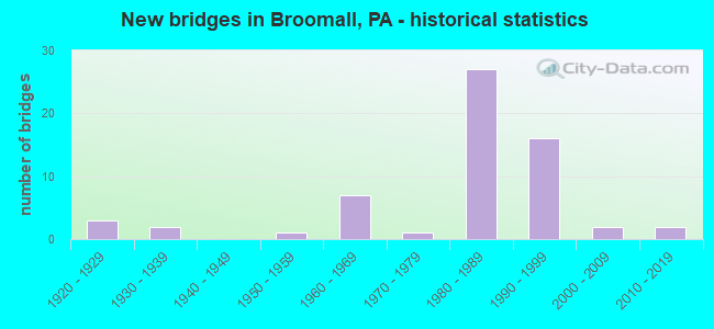
- New bridges - historical statistics
- 31920-1929
- 21930-1939
- 11950-1959
- 71960-1969
- 11970-1979
- 271980-1989
- 161990-1999
- 22000-2009
- 22010-2019
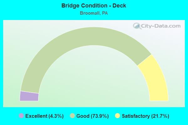
- Bridge Condition - Deck
- 4.3%Excellent
- 73.9%Good
- 21.7%Satisfactory
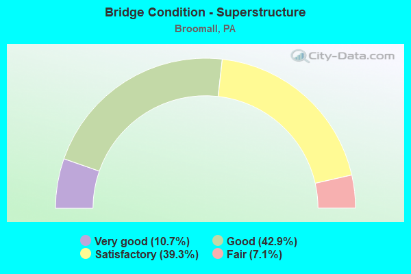
- Bridge Condition - Superstructure
- 10.7%Very good
- 42.9%Good
- 39.3%Satisfactory
- 7.1%Fair
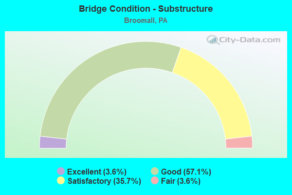
- Bridge Condition - Substructure
- 3.6%Excellent
- 57.1%Good
- 35.7%Satisfactory
- 3.6%Fair
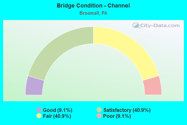
- Bridge Condition - Channel
- 9.1%Good
- 40.9%Satisfactory
- 40.9%Fair
- 9.1%Poor
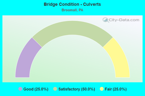
- Bridge Condition - Culverts
- 25.0%Good
- 50.0%Satisfactory
- 25.0%Fair
Find on map >> Show street view
Structure Number: 15112, Location: HAVERFORD TWP. 25J04 (Lat: 39.998528, Lng: -75.349294), Route carried "under" structure: State highway , Year Built: 1967, Structure Length: 0. m, Average Daily Traffic: 7,966 (year 2022), Truck Traffic: 2%, Features Intersected: DARBY ROAD, Facility Carried by Structure: MID-COUNTY EXWY.SB
Minimum Vertical Clearance: 4.42m (14.50ft), Kilometerpoint: 14.124, Lanes on structure: 3, Lanes under structure: 2, Material/Design: Prestressed concrete, Design/Construction: Box Beam or Girders - Single/Spread, Length of Maximum Span: 21.3m (69.9ft)
Find on map >> Show street view
Structure Number: 15175, Location: .2MI.SOUTH RTE.3 25K08 (Lat: 39.973761, Lng: -75.340769), Route carried "under" structure: Interstate 476, Year Built: 1989, Structure Length: 0. m, Average Daily Traffic: 39,449 (year 2021), Truck Traffic: 10%, Features Intersected: MID-COUNTY EXPRESSWAY, Facility Carried by Structure: LAWRENCE ROAD
Minimum Vertical Clearance: 5.77m (18.93ft), Kilometerpoint: 12.841, Lanes on structure: 2, Lanes under structure: 2, Material/Design: Prestressed concrete continuous, Design/Construction: Stringer/Multi-beam, Length of Maximum Span: 32.6m (107.0ft)
Find on map >> Show street view
Structure Number: 15175, Location: .2MI.SOUTH RTE.3 25K08 (Lat: 39.973761, Lng: -75.340769), Route carried "under" structure: Interstate 476, Year Built: 1989, Structure Length: 0. m, Average Daily Traffic: 37,924 (year 2021), Truck Traffic: 10%, Features Intersected: MID-COUNTY EXPRESSWAY, Facility Carried by Structure: LAWRENCE ROAD
Minimum Vertical Clearance: 6.14m (20.14ft), Kilometerpoint: 12.830, Lanes on structure: 2, Lanes under structure: 3, Material/Design: Prestressed concrete continuous, Design/Construction: Stringer/Multi-beam, Length of Maximum Span: 32.6m (107.0ft)
Find on map >> Show street view
Structure Number: 15194, Location: NR.HAVERFORD HOSP. 25K05 (Lat: 39.989961, Lng: -75.344339), Route carried "under" structure: Interstate 476, Year Built: 1988, Structure Length: 0. m, Average Daily Traffic: 46,596 (year 2021), Truck Traffic: 9%, Features Intersected: I-476;CREEK RD;DARBY, Facility Carried by Structure: MARPLE ROAD(RELOC)
Minimum Vertical Clearance: 5.49m (18.01ft), Kilometerpoint: 15.245, Lanes on structure: 2, Lanes under structure: 3, Material/Design: Steel continuous, Design/Construction: Stringer/Multi-beam, Length of Maximum Span: 49.7m (163.1ft)
Find on map >> Show street view
Structure Number: 15194, Location: NR.HAVERFORD HOSP. 25K05 (Lat: 39.989961, Lng: -75.344339), Route carried "under" structure: State highway , Year Built: 1988, Structure Length: 0. m, Average Daily Traffic: 1,692 (year 2022), Truck Traffic: 4%, Features Intersected: I-476;CREEK RD;DARBY, Facility Carried by Structure: MARPLE ROAD(RELOC)
Minimum Vertical Clearance: 4.62m (15.16ft), Kilometerpoint: 1.246, Lanes on structure: 2, Lanes under structure: 2, Material/Design: Steel continuous, Design/Construction: Stringer/Multi-beam, Length of Maximum Span: 49.7m (163.1ft)
Find on map >> Show street view
Structure Number: 15194, Location: NR.HAVERFORD HOSP. 25K05 (Lat: 39.989961, Lng: -75.344339), Route carried "under" structure: Interstate 476, Year Built: 1988, Structure Length: 0. m, Average Daily Traffic: 48,339 (year 2021), Truck Traffic: 9%, Features Intersected: I-476;CREEK RD;DARBY, Facility Carried by Structure: MARPLE ROAD(RELOC)
Minimum Vertical Clearance: 6.04m (19.82ft), Kilometerpoint: 15.249, Lanes on structure: 2, Lanes under structure: 3, Material/Design: Steel continuous, Design/Construction: Stringer/Multi-beam, Length of Maximum Span: 49.7m (163.1ft)
Find on map >> Show street view
Structure Number: 15238, Location: CARDINAL O'HARA HS 25J13 (Lat: 39.945481, Lng: -75.348494), Route carried "under" structure: Interstate 476, Year Built: 1989, Structure Length: 0. m, Average Daily Traffic: 39,449 (year 2021), Truck Traffic: 10%, Features Intersected: MID-COUNTY EXPRESSWAY, Facility Carried by Structure: SPRINGFIELD ROAD
Minimum Vertical Clearance: 6.15m (20.18ft), Kilometerpoint: 8.806, Lanes on structure: 2, Lanes under structure: 2, Material/Design: Prestressed concrete continuous, Design/Construction: Stringer/Multi-beam, Length of Maximum Span: 25.9m (85.0ft)
Find on map >> Show street view
Structure Number: 15238, Location: CARDINAL O'HARA HS 25J13 (Lat: 39.945481, Lng: -75.348494), Route carried "under" structure: Interstate 476, Year Built: 1989, Structure Length: 0. m, Average Daily Traffic: 37,924 (year 2021), Truck Traffic: 10%, Features Intersected: MID-COUNTY EXPRESSWAY, Facility Carried by Structure: SPRINGFIELD ROAD
Minimum Vertical Clearance: 6.61m (21.69ft), Kilometerpoint: 8.835, Lanes on structure: 2, Lanes under structure: 3, Material/Design: Prestressed concrete continuous, Design/Construction: Stringer/Multi-beam, Length of Maximum Span: 25.9m (85.0ft)
Find on map >> Show street view
Structure Number: 15505, Location: 1MI.W.SPGFLD.RD. 34G02 (Lat: 39.937233, Lng: -75.362764), Route carried "under" structure: Bypass US 1, Year Built: 1990, Structure Length: 0. m, Average Daily Traffic: 10,072 (year 2020), Truck Traffic: 5%, Features Intersected: MEDIA BYPSS(US-1)/3697B1, Facility Carried by Structure: RAMP A(NB)TO I-476
Minimum Vertical Clearance: 4.57m (14.99ft), Kilometerpoint: 21.218, Lanes on structure: 1, Lanes under structure: 2, Material/Design: Prestressed concrete continuous, Design/Construction: Box Beam or Girders - Multiple, Length of Maximum Span: 23.8m (78.1ft)
Find on map >> Show street view
Structure Number: 15505, Location: 1MI.W.SPGFLD.RD. 34G02 (Lat: 39.937233, Lng: -75.362764), Route carried "under" structure: Bypass US 1, Year Built: 1990, Structure Length: 0. m, Average Daily Traffic: 9,566 (year 2020), Truck Traffic: 5%, Features Intersected: MEDIA BYPSS(US-1)/3697B1, Facility Carried by Structure: RAMP A(NB)TO I-476
Minimum Vertical Clearance: 4.60m (15.09ft), Kilometerpoint: 21.119, Lanes on structure: 1, Lanes under structure: 2, Material/Design: Prestressed concrete continuous, Design/Construction: Box Beam or Girders - Multiple, Length of Maximum Span: 23.8m (78.1ft)
Find on map >> Show street view
Structure Number: 15508, Location: MEDIA BYPASS INT. 34G02 (Lat: 39.938333, Lng: -75.366667), Route carried "under" structure: State highway , Year Built: 1990, Structure Length: 0. m, Average Daily Traffic: 5,966 (year 2022), Truck Traffic: 6%, Features Intersected: RELOCATED MARPLE ROAD, Facility Carried by Structure: RAMP D(SB)TO RTE 1
Minimum Vertical Clearance: 11.63m (38.16ft), Kilometerpoint: 2.660, Lanes on structure: 1, Lanes under structure: 2, Material/Design: Prestressed concrete continuous, Design/Construction: Stringer/Multi-beam, Length of Maximum Span: 35.1m (115.2ft)
Find on map >> Show street view
Structure Number: 15509, Location: .5MI.E.STATE RD. 34G02 (Lat: 39.936667, Lng: -75.366667), Route carried "under" structure: Bypass US 1, Year Built: 1990, Structure Length: 0. m, Average Daily Traffic: 10,072 (year 2020), Truck Traffic: 5%, Features Intersected: MEDIA BY-PASS (US-1), Facility Carried by Structure: RAMP D(SB)TO I-476
Minimum Vertical Clearance: 4.65m (15.26ft), Kilometerpoint: 22.206, Lanes on structure: 1, Lanes under structure: 2, Material/Design: Prestressed concrete continuous, Design/Construction: Box Beam or Girders - Multiple, Length of Maximum Span: 23.8m (78.1ft)
Find on map >> Show street view
Structure Number: 15509, Location: .5MI.E.STATE RD. 34G02 (Lat: 39.936667, Lng: -75.366667), Route carried "under" structure: Bypass US 1, Year Built: 1990, Structure Length: 0. m, Average Daily Traffic: 9,566 (year 2020), Truck Traffic: 5%, Features Intersected: MEDIA BY-PASS (US-1), Facility Carried by Structure: RAMP D(SB)TO I-476
Minimum Vertical Clearance: 4.52m (14.83ft), Kilometerpoint: 22.100, Lanes on structure: 1, Lanes under structure: 2, Material/Design: Prestressed concrete continuous, Design/Construction: Box Beam or Girders - Multiple, Length of Maximum Span: 23.8m (78.1ft)
Find on map >> Show street view
Structure Number: 15511, Location: .5MI.E.STATE ROAD 34G02 (Lat: 39.939214, Lng: -75.361536), Route carried "under" structure: State highway , Year Built: 1990, Structure Length: 0. m, Average Daily Traffic: 5,966 (year 2022), Truck Traffic: 6%, Features Intersected: RELOCATED MARPLE ROAD, Facility Carried by Structure: RAMP A(NB)TO I-476
Minimum Vertical Clearance: 11.35m (37.24ft), Kilometerpoint: 1.751, Lanes on structure: 1, Lanes under structure: 2, Material/Design: Prestressed concrete continuous, Design/Construction: Stringer/Multi-beam, Length of Maximum Span: 43.3m (142.1ft)