Bridge Statistics for Bucksport, Maine (ME)
Condition, Traffic, Stress, Structural Evaluation, Project Costs
- National Bridge Inventory (NBI) Statistics
- 10Number of bridges
- 230ft / 69.6mTotal length
- 59,499Total average daily traffic
- 4,601Total average daily truck traffic
- National Bridge Inventory (NBI) Registered Bridges for Bucksport
- No street view available for this location
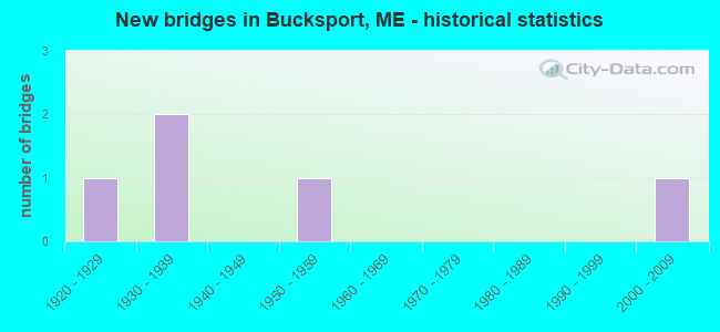
- New bridges - historical statistics
- 11920-1929
- 21930-1939
- 11950-1959
- 12000-2009


- Bridge Condition - Deck
- 20.0%Very good
- 20.0%Satisfactory
- 40.0%Fair
- 20.0%Poor

- Bridge Condition - Superstructure
- 20.0%Very good
- 20.0%Satisfactory
- 40.0%Fair
- 20.0%Poor

- Bridge Condition - Substructure
- 20.0%Very good
- 80.0%Fair

- Bridge Condition - Channel
- 20.0%Excellent
- 40.0%Good
- 40.0%Satisfactory
Find on map >> Show street view
Structure Number: 2496, Location: 0.1 MI W OF JCT RTE US 1 (Lat: 44.571239, Lng: -68.788839), Route carried "on" structure: State highway 15, Year Built: 1923, Status: Open, Structure Length: 1.34m (4.40ft), Average Daily Traffic: 9,693 (year 2016), Truck Traffic: 5%, Average Future Daily Traffic: 13,570 (year 2036), Design Load: H 20, Features Intersected: MILL STREAM
Minimum Vertical Clearance: 30+ m (98+ ft), Kilometerpoint: 65.355, Lanes on structure: 3, Base Highway Network: Yes, Owner: State Highway Agency, Approaching Roadway Width: 6.7m (22.0ft), Material/Design: Concrete, Design/Construction: Tee Beam, Number Of Spans In Main Unit: 1, Length of Maximum Span: 12.2m (40.0ft), Curb or Sidewalk Widths: Left: 1.5m (4.9ft), Right: 1.5m (4.9ft), Curb-To-Curb Width: 9.8m (32.2ft), Out-to-Out Width: 13.6m (44.6ft)
Condition: Deck: Poor, Superstructure: Poor, Substructure: Fair, Channel: Good, Operating Rating: 41.8 metric tons, Method Used To Determine Operating Rating: Load and Resistance Factor Rating (LRFR) rating reported by rating factor(RF) method using HL-93 loadings, Inventory Rating: 32.1 metric tons, Method Used To Determine Inventory Rating: Load and Resistance Factor Rating (LRFR) rating reported by rating factor(RF) method using HL-93 loadings, Structural Evaluation: Meets minimum limits, Deck Geometry: High priority of replacement, Waterway Adequacy: Superior to present desirable criteria, Approach Roadway Alignment: Equal to present desirable criteria, Designated Inspection Frequency: Every 24 months, Inspection Date: August 2021, Deck Structure Type: Concrete Cast-file-Place, Wearing Surface/Protective System: Wearing Surface: Bituminous
Find on map >> Show street view
Structure Number: 3472, Location: 3.6 MI N JCT US1 (Lat: 44.612811, Lng: -68.745631), Route carried "on" structure: City street , Year Built: 1937, Status: Open, Structure Length: 0.72m (2.36ft), Average Daily Traffic: 671 (year 2016), Truck Traffic: 5%, Average Future Daily Traffic: 1,074 (year 2036), Features Intersected: STUBBS BROOK, Facility Carried by Structure: BUCKS MILL ROAD
Minimum Vertical Clearance: 30+ m (98+ ft), Kilometerpoint: 6.341, Lanes on structure: 2, Owner: State Highway Agency, Approaching Roadway Width: 7.3m (24.0ft), Skew: 1 degrees, Material/Design: Concrete, Design/Construction: Slab, Number Of Spans In Main Unit: 1, Length of Maximum Span: 6.1m (20.0ft), Curb or Sidewalk Widths: Left: 0.2m (0.7ft), Right: 0.2m (0.7ft), Curb-To-Curb Width: 7.3m (24.0ft), Out-to-Out Width: 7.9m (25.9ft)
Condition: Deck: Fair, Superstructure: Fair, Substructure: Fair, Channel: Good, Operating Rating: 35.6 metric tons, Method Used To Determine Operating Rating: Load and Resistance Factor Rating (LRFR) rating reported by rating factor(RF) method using HL-93 loadings, Inventory Rating: 27.5 metric tons, Method Used To Determine Inventory Rating: Load and Resistance Factor Rating (LRFR) rating reported by rating factor(RF) method using HL-93 loadings, Structural Evaluation: Somewhat better than minimum adequacy, Deck Geometry: Meets minimum limits, Waterway Adequacy: Superior to present desirable criteria, Approach Roadway Alignment: Equal to present desirable criteria, Designated Inspection Frequency: Every 24 months, Inspection Date: October 2021, Deck Structure Type: Concrete Cast-file-Place, Wearing Surface/Protective System: Wearing Surface: Bituminous
Find on map >> Show street view
Structure Number: 3561, Location: 2.7 MI N OF JCT RTE US 1 (Lat: 44.602311, Lng: -68.732211), Route carried "on" structure: County highway 46, Year Built: 1938, Status: Open, Structure Length: 0.92m (3.02ft), Average Daily Traffic: 1,263 (year 2016), Truck Traffic: 5%, Average Future Daily Traffic: 1,895 (year 2036), Design Load: H 15, Features Intersected: STUBBS BROOK
Minimum Vertical Clearance: 30+ m (98+ ft), Kilometerpoint: 4.619, Lanes on structure: 2, Owner: State Highway Agency, Approaching Roadway Width: 7.3m (24.0ft), Skew: 2 degrees, Material/Design: Concrete, Design/Construction: Slab, Number Of Spans In Main Unit: 1, Length of Maximum Span: 7.9m (25.9ft), Curb or Sidewalk Widths: Left: 0.2m (0.7ft), Right: 0.2m (0.7ft), Curb-To-Curb Width: 7.3m (24.0ft), Out-to-Out Width: 8.3m (27.2ft)
Condition: Deck: Satisfactory, Superstructure: Satisfactory, Substructure: Fair, Channel: Satisfactory, Operating Rating: 41.8 metric tons, Method Used To Determine Operating Rating: Load and Resistance Factor Rating (LRFR) rating reported by rating factor(RF) method using HL-93 loadings, Inventory Rating: 32.1 metric tons, Method Used To Determine Inventory Rating: Load and Resistance Factor Rating (LRFR) rating reported by rating factor(RF) method using HL-93 loadings, Structural Evaluation: Somewhat better than minimum adequacy, Deck Geometry: Meets minimum limits, Waterway Adequacy: Equal to present desirable criteria, Approach Roadway Alignment: Equal to present desirable criteria, Designated Inspection Frequency: Every 24 months, Inspection Date: October 2021, Deck Structure Type: Concrete Cast-file-Place, Wearing Surface/Protective System: Wearing Surface: Latex Concrete
Find on map >> Show street view
Structure Number: 5719, Location: 0.3 MI E OF JCT RTE 46 (Lat: 44.595211, Lng: -68.734969), Route carried "on" structure: City street , Year Built: 1958, Status: Open, Structure Length: 1.86m (6.10ft), Average Daily Traffic: 669 (year 2016), Truck Traffic: 5%, Average Future Daily Traffic: 1,070 (year 2036), Features Intersected: STUBBS BROOK, Facility Carried by Structure: DUCK COVE ROAD
Minimum Vertical Clearance: 30+ m (98+ ft), Kilometerpoint: 0.982, Lanes on structure: 2, Owner: State Highway Agency, Approaching Roadway Width: 6.7m (22.0ft), Material/Design: Steel continuous, Design/Construction: Stringer/Multi-beam, Number Of Spans In Main Unit: 3, Length of Maximum Span: 6.1m (20.0ft), Curb or Sidewalk Widths: Left: 0.3m (1.0ft), Right: 0.3m (1.0ft), Curb-To-Curb Width: 6.7m (22.0ft), Out-to-Out Width: 7.9m (25.9ft)
Condition: Deck: Fair, Superstructure: Fair, Substructure: Fair, Channel: Satisfactory, Operating Rating: 37.9 metric tons, Method Used To Determine Operating Rating: Load and Resistance Factor Rating (LRFR) rating reported by rating factor(RF) method using HL-93 loadings, Inventory Rating: 28.8 metric tons, Method Used To Determine Inventory Rating: Load and Resistance Factor Rating (LRFR) rating reported by rating factor(RF) method using HL-93 loadings, Structural Evaluation: Somewhat better than minimum adequacy, Deck Geometry: Meets minimum limits, Waterway Adequacy: Equal to present minimum criteria, Approach Roadway Alignment: Equal to present desirable criteria, Designated Inspection Frequency: Every 24 months, Underwater Inspection Frequency: Every 60 months, Inspection Date: August 2021, Underwater Inspection Date: August 2019, Deck Structure Type: Concrete Cast-file-Place, Wearing Surface/Protective System: Wearing Surface: Monolithic Concrete
Find on map >> Show street view
Structure Number: 6421, Location: County line (Lat: 44.560031, Lng: -68.802281), Route carried "on" structure: State highway 1, Year Built: 2007, Status: Open, Structure Length: 64.80m (212.60ft), Average Daily Traffic: 4,292 (year 2016), Truck Traffic: 5%, Average Future Daily Traffic: 6,009 (year 2036), Design Load: HS 25 or greater, Features Intersected: Penobscot River(s chan)
Minimum Vertical Clearance: 30+ m (98+ ft), Kilometerpoint: 275.698, Lanes on structure: 2, Base Highway Network: Yes, Owner: State Highway Agency, Approaching Roadway Width: 12.2m (40.0ft), Skew: 30 degrees, Material/Design: Prestressed concrete continuous, Design/Construction: Stayed Girder, Number Of Spans In Main Unit: 3, Length of Maximum Span: 353.9m (1,161.1ft), Curb or Sidewalk Widths: Left: 0.5m (1.6ft), Right: 0.5m (1.6ft), Curb-To-Curb Width: 6.1m (20.0ft), Out-to-Out Width: 17.5m (57.4ft)
Condition: Deck: Very good, Superstructure: Very good, Substructure: Very good, Channel: Excellent, Operating Rating: 68.4 metric tons, Method Used To Determine Operating Rating: Load and Resistance Factor Rating (LRFR) rating reported by rating factor(RF) method using HL-93 loadings, Inventory Rating: 37.9 metric tons, Method Used To Determine Inventory Rating: Load and Resistance Factor Rating (LRFR) rating reported by rating factor(RF) method using HL-93 loadings, Structural Evaluation: Equal to present desirable criteria, Deck Geometry: High priority of replacement, Waterway Adequacy: Superior to present desirable criteria, Approach Roadway Alignment: Better than present minimum criteria, Designated Inspection Frequency: Every 24 months, Other Special Inspection Frequency: Every 63 months, Inspection Date: Febuary 2021, Other Special Inspection Date: November 2018, Deck Structure Type: Concrete Cast-file-Place, Wearing Surface/Protective System: Wearing Surface: Bituminous, Membrane: Preformed Fabric, Deck Protection: Epoxy Coated Reinforcing
Find on map >> Show street view
Location: 1.4 MI N OF SIDNEY TL (Lat: 44.524714, Lng: -68.721503), Route carried "under" structure: Other road 32400, Structure Length: 0. m, Average Daily Traffic: 1,770 (year 2014), Truck Traffic: 8%, Features Intersected: INTERSTATE 95 NB, Facility Carried by Structure: WEBB ROAD
Minimum Vertical Clearance: 4.47m (14.67ft), Kilometerpoint: 2.527, Lanes on structure: 2, Length of Maximum Span: 0.0m
Find on map >> Show street view
Location: 4.5 MI N TOWNLINE (Lat: 44.566128, Lng: -68.781975), Route carried "under" structure: Other road 52310, Structure Length: 0. m, Average Daily Traffic: 16,920 (year 2014), Truck Traffic: 11%, Features Intersected: ARMSTRONG ROAD, Facility Carried by Structure: INTERSTATE 95
Minimum Vertical Clearance: 4.72m (15.49ft), Kilometerpoint: 204.837, Lanes on structure: 4, Length of Maximum Span: 0.0m
Find on map >> Show street view
Location: 0.8 MI S TOWNLINE (Lat: 44.571683, Lng: -68.716281), Route carried "under" structure: Other road 82310, Structure Length: 0. m, Average Daily Traffic: 14,031 (year 2014), Truck Traffic: 5%, Features Intersected: I-95 NORTHBOUND, Facility Carried by Structure: ROUTE 104
Minimum Vertical Clearance: 4.52m (14.83ft), Kilometerpoint: 32.670, Lanes on structure: 4, Length of Maximum Span: 0.0m
Find on map >> Show street view
Location: .5 MI N TOWNLINE (Lat: 44.602269, Lng: -68.788544), Route carried "under" structure: 32400, Structure Length: 0. m, Average Daily Traffic: 1,640 (year 2014), Truck Traffic: 8%, Features Intersected: I95 NB, Facility Carried by Structure: RIVER ROAD
Minimum Vertical Clearance: 4.57m (14.99ft), Kilometerpoint: 12.569, Lanes on structure: 4, Length of Maximum Span: 0.0m
Find on map >> Show street view
Location: 0.5 MI N OF JCT RR STREET (Lat: 44.650042, Lng: -68.801928), Route carried "under" structure: 62310, Structure Length: 0. m, Average Daily Traffic: 8,550 (year 2014), Truck Traffic: 11%, Features Intersected: HILL ROAD, Facility Carried by Structure: INTERSTATE 95
Minimum Vertical Clearance: 4.81m (15.78ft), Kilometerpoint: 221.108, Lanes on structure: 4, Length of Maximum Span: 0.0m