Bucksport, Maine
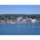
Bucksport: View of Beautiful Bucksport, Maine from Fort Knox
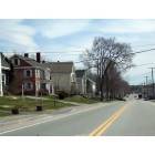
Bucksport: Main Street

Bucksport: Main Street
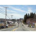
Bucksport: Main Street

Bucksport: Bucksport in winter

Bucksport: A view of the new bridge from the river walkway in the town

Bucksport: RR crossing sign with Paper factory in the background

Bucksport: View of Penobscot Narrows Bridge
- add
your
Submit your own pictures of this place and show them to the world
- OSM Map
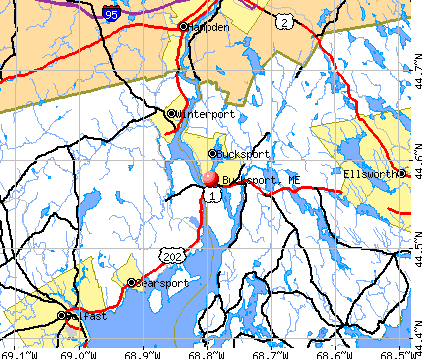
- General Map
- Google Map
- MSN Map
Population change since 2000: -2.9%
| Males: 1,421 | |
| Females: 1,464 |
| Median resident age: | 42.0 years |
| Maine median age: | 45.1 years |
Zip codes: 04416.
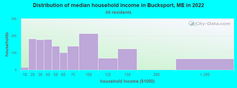
| Bucksport: | $49,868 |
| ME: | $69,543 |
Estimated per capita income in 2022: $30,343 (it was $18,179 in 2000)
Bucksport CDP income, earnings, and wages data
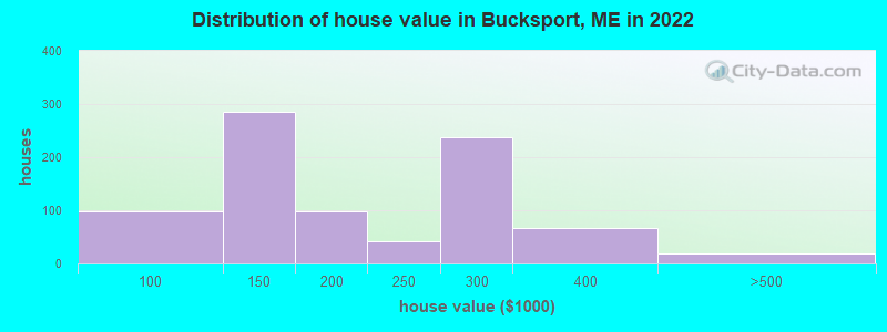
Estimated median house or condo value in 2022: $195,158 (it was $90,400 in 2000)
| Bucksport: | $195,158 |
| ME: | $290,600 |
Mean prices in 2022: all housing units: $174,641; detached houses: $176,207; mobile homes: $106,524
Median gross rent in 2022: $687.
(12.5% for White Non-Hispanic residents, 59.0% for Hispanic or Latino residents, 100.0% for other race residents)
Detailed information about poverty and poor residents in Bucksport, ME
Compare current foreclosures near Bucksport, ME:
| Photo | Address | Area | Beds / Baths | Price | Details |
|---|---|---|---|---|---|

|
#1
Central St
Bucksport, ME 04416
|
- sq. feet
|
- baths - beds |
$63,000
|
show details |

|
#2
Hinks St
Bucksport, ME 04416
|
1,320 sq. feet
|
1 baths 4 beds |
show details | |

|
#3
Mount Ephraim Rd
Searsport, ME 04974
|
1,972 sq. feet
|
2 baths 4 beds |
$140,000
|
show details |

|
#4
Central St
Bucksport, ME 04416
|
- sq. feet
|
- baths - beds |
show details | |

|
#5
Hinks St
Bucksport, ME 04416
|
- sq. feet
|
- baths - beds |
show details | |

|
#6
Surry Rd
Orland, ME 04472
|
- sq. feet
|
4 baths 5 beds |
$174,900
|
show details |

|
#7
Western Ave
Hampden, ME 04444
|
1,976 sq. feet
|
2 baths 4 beds |
show details | |

|
#8
Western Ave
Hampden, ME 04444
|
1,825 sq. feet
|
1 baths 3 beds |
show details | |

|
#9
Allen St
Bangor, ME 04401
|
1,200 sq. feet
|
1 baths 3 beds |
show details | |

|
#10
Grove St
Bangor, ME 04401
|
910 sq. feet
|
1 baths 3 beds |
show details |
| Photo | Address | Area | Beds / Baths | Price | Details |
|---|---|---|---|---|---|

|
#11
Ichabod Ln
Hampden, ME 04444
|
960 sq. feet
|
1 baths 3 beds |
show details | |

|
#12
Elm St
Bangor, ME 04401
|
- sq. feet
|
2 baths 4 beds |
show details | |

|
#13
Cedar St Apt 4
Bangor, ME 04401
|
- sq. feet
|
- baths - beds |
show details | |

|
#14
Pine St # B
Bangor, ME 04401
|
- sq. feet
|
- baths - beds |
show details | |

|
#15
Harborside Rd
Harborside, ME 04642
|
- sq. feet
|
- baths - beds |
show details | |

|
#16
Loop Rd
Searsport, ME 04974
|
- sq. feet
|
- baths - beds |
show details | |

|
#17
Front Ridge Rd
Penobscot, ME 04476
|
- sq. feet
|
- baths - beds |
show details | |

|
#18
Baker Blvd Ste 205
Brewer, ME 04412
|
- sq. feet
|
- baths - beds |
show details | |

|
#19
Muskrat Farm Rd
Stockton Springs, ME 04981
|
- sq. feet
|
- baths - beds |
show details | |

|
#20
Indian Hill Ln
Frankfort, ME 04438
|
- sq. feet
|
- baths - beds |
show details |
| Photo | Address | Area | Beds / Baths | Price | Details |
|---|---|---|---|---|---|

|
#21
Pleasant Hill Ln
Orrington, ME 04474
|
- sq. feet
|
- baths - beds |
show details | |

|
#22
Stillwater Ave
Bangor, ME 04401
|
- sq. feet
|
- baths - beds |
show details | |

|
#23
Goose Falls Rd
Harborside, ME 04642
|
- sq. feet
|
- baths - beds |
show details | |

|
#24
Railroad Ln
Holden, ME 04429
|
- sq. feet
|
- baths - beds |
show details | |

|
#25
Treats Falls Dr
Brewer, ME 04412
|
- sq. feet
|
- baths - beds |
show details | |

|
#26
Purple Heart Hwy
Brooks, ME 04921
|
- sq. feet
|
- baths - beds |
show details | |

|
#27
Gott Brook Hts
Orland, ME 04472
|
- sq. feet
|
- baths - beds |
show details | |

|
#28
Kenduskeag Ave # 24
Bangor, ME 04401
|
- sq. feet
|
- baths - beds |
show details | |

|
Check over 1 million property listings on Foreclosure.com!
|
browse all offers | |||


- 2,81194.1%White alone
- 1354.5%Hispanic
- 160.5%Two or more races
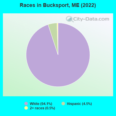
Races in Bucksport detailed stats: ancestries, foreign born residents, place of birth
According to our research of Maine and other state lists, there were 7 registered sex offenders living in Bucksport, Maine as of May 22, 2024.
The ratio of all residents to sex offenders in Bucksport is 367 to 1.
Type |
2009 |
2010 |
2011 |
2012 |
2013 |
2014 |
2015 |
2016 |
2017 |
2018 |
2019 |
2020 |
2021 |
2022 |
|---|---|---|---|---|---|---|---|---|---|---|---|---|---|---|
| Murders (per 100,000) | 0 (0.0) | 0 (0.0) | 0 (0.0) | 0 (0.0) | 0 (0.0) | 0 (0.0) | 0 (0.0) | 0 (0.0) | 1 (20.3) | 0 (0.0) | 0 (0.0) | 0 (0.0) | 0 (0.0) | 0 (0.0) |
| Rapes (per 100,000) | 0 (0.0) | 1 (20.3) | 4 (81.3) | 1 (20.2) | 0 (0.0) | 1 (20.1) | 1 (20.2) | 1 (20.3) | 0 (0.0) | 0 (0.0) | 0 (0.0) | 5 (101.5) | 1 (20.3) | 0 (0.0) |
| Robberies (per 100,000) | 0 (0.0) | 0 (0.0) | 0 (0.0) | 2 (40.4) | 0 (0.0) | 1 (20.1) | 0 (0.0) | 2 (40.6) | 0 (0.0) | 0 (0.0) | 0 (0.0) | 0 (0.0) | 0 (0.0) | 0 (0.0) |
| Assaults (per 100,000) | 12 (245.3) | 12 (243.7) | 17 (345.3) | 14 (283.1) | 8 (162.0) | 13 (261.9) | 8 (161.8) | 1 (20.3) | 2 (40.6) | 1 (20.4) | 2 (40.6) | 3 (60.9) | 3 (61.0) | 2 (39.4) |
| Burglaries (per 100,000) | 27 (551.9) | 32 (649.9) | 31 (629.7) | 53 (1,072) | 25 (506.4) | 18 (362.6) | 16 (323.6) | 8 (162.4) | 9 (182.8) | 5 (101.8) | 5 (101.5) | 5 (101.5) | 8 (162.7) | 2 (39.4) |
| Thefts (per 100,000) | 73 (1,492) | 81 (1,645) | 78 (1,584) | 74 (1,496) | 48 (972.3) | 50 (1,007) | 49 (991.1) | 52 (1,055) | 44 (893.6) | 32 (651.2) | 46 (933.8) | 31 (629.2) | 29 (589.8) | 40 (787.4) |
| Auto thefts (per 100,000) | 2 (40.9) | 3 (60.9) | 2 (40.6) | 4 (80.9) | 5 (101.3) | 1 (20.1) | 1 (20.2) | 1 (20.3) | 2 (40.6) | 0 (0.0) | 4 (81.2) | 5 (101.5) | 3 (61.0) | 2 (39.4) |
| Arson (per 100,000) | 1 (20.4) | 1 (20.3) | 1 (20.3) | 1 (20.2) | 0 (0.0) | 0 (0.0) | 0 (0.0) | 0 (0.0) | 0 (0.0) | 0 (0.0) | 1 (20.3) | 0 (0.0) | 0 (0.0) | 1 (19.7) |
| City-Data.com crime index | 150.7 | 181.2 | 244.8 | 226.3 | 114.8 | 141.8 | 112.5 | 87.7 | 100.5 | 37.2 | 59.1 | 133.8 | 68.3 | 45.3 |
The City-Data.com crime index weighs serious crimes and violent crimes more heavily. Higher means more crime, U.S. average is 246.1. It adjusts for the number of visitors and daily workers commuting into cities.
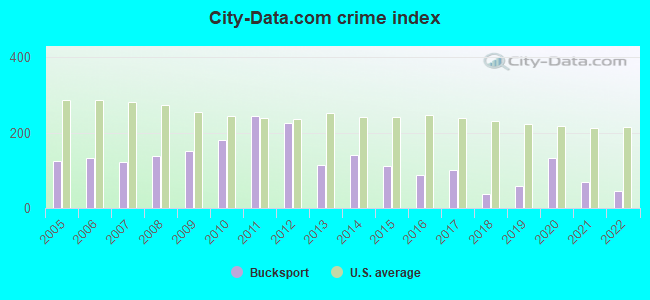
Crime rate in Bucksport detailed stats: murders, rapes, robberies, assaults, burglaries, thefts, arson
Full-time law enforcement employees in 2021, including police officers: 14 (10 officers - 9 male; 1 female).
| Officers per 1,000 residents here: | 2.03 |
| Maine average: | 1.71 |
 Recent articles from our blog. Our writers, many of them Ph.D. graduates or candidates, create easy-to-read articles on a wide variety of topics.

 | Bucksport/Verona Island (3 replies) |
| Paper mill asking for donations. Of paper. (14 replies) |
| Possibly relocating from FL, have some questions. (40 replies) |
| Blue Hill Peninsula- talk to me (12 replies) |
| Can I afford to live in Maine? (34 replies) |
| Belfast vs Bucksport? (3 replies) |
Latest news from Bucksport, ME collected exclusively by city-data.com from local newspapers, TV, and radio stations
Bucksport, ME City Guides:
Ancestries: English (32.5%), French Canadian (10.7%), American (10.2%), Irish (8.1%), German (5.9%), Swedish (5.0%).
Current Local Time: EST time zone
Incorporated on 06/27/1792
Elevation: 43 feet
Land area: 11.4 square miles.
Population density: 253 people per square mile (very low).
17 residents are foreign born
| This place: | 0.6% |
| Maine: | 3.8% |
Median real estate property taxes paid for housing units with mortgages in 2022: $1,754 (1.0%)
Median real estate property taxes paid for housing units with no mortgage in 2022: $2,011 (0.7%)
Nearest city with pop. 50,000+: Portland, ME  (96.7 miles , pop. 64,249).
Nearest city with pop. 200,000+: Boston, MA (194.0 miles , pop. 589,141).
Nearest city with pop. 1,000,000+: Bronx, NY (364.9 miles , pop. 1,332,650).
Nearest cities:
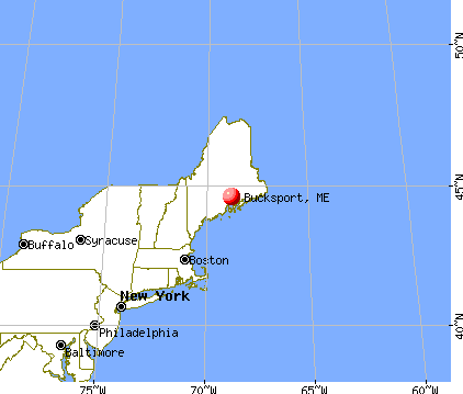
), ), ), ), )Latitude: 44.58 N, Longitude: 68.79 W
Area code: 207

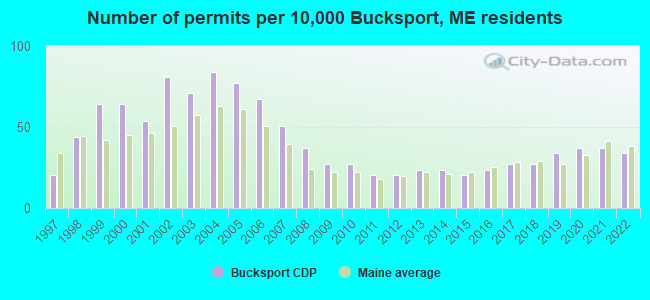
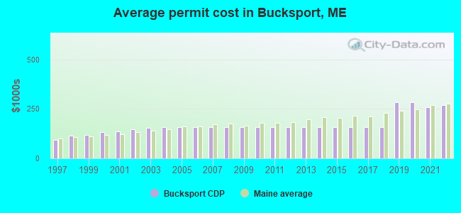
Single-family new house construction building permits:
- 2022: 10 buildings, average cost: $269,200
- 2021: 11 buildings, average cost: $259,200
- 2020: 11 buildings, average cost: $282,200
- 2019: 10 buildings, average cost: $282,200
- 2018: 8 buildings, average cost: $159,300
- 2017: 8 buildings, average cost: $159,300
- 2016: 7 buildings, average cost: $159,300
- 2015: 6 buildings, average cost: $159,300
- 2014: 7 buildings, average cost: $159,300
- 2013: 7 buildings, average cost: $159,300
- 2012: 6 buildings, average cost: $159,300
- 2011: 6 buildings, average cost: $159,300
- 2010: 8 buildings, average cost: $159,300
- 2009: 8 buildings, average cost: $159,300
- 2008: 11 buildings, average cost: $159,300
- 2007: 15 buildings, average cost: $159,300
- 2006: 20 buildings, average cost: $159,300
- 2005: 23 buildings, average cost: $159,300
- 2004: 25 buildings, average cost: $159,300
- 2003: 21 buildings, average cost: $152,800
- 2002: 24 buildings, average cost: $146,800
- 2001: 16 buildings, average cost: $137,100
- 2000: 19 buildings, average cost: $130,600
- 1999: 19 buildings, average cost: $120,200
- 1998: 13 buildings, average cost: $116,200
- 1997: 6 buildings, average cost: $91,700
| Here: | 4.3% |
| Maine: | 3.4% |
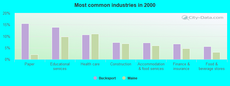
- Paper (15.5%)
- Educational services (13.9%)
- Health care (10.7%)
- Construction (7.3%)
- Accommodation & food services (7.1%)
- Finance & insurance (6.7%)
- Food & beverage stores (5.6%)
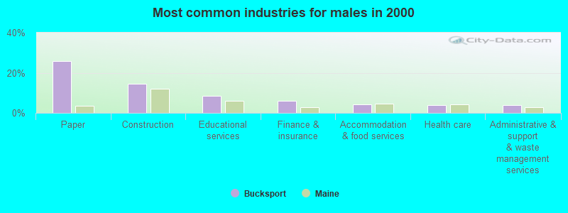
- Paper (25.7%)
- Construction (14.6%)
- Educational services (8.4%)
- Finance & insurance (6.2%)
- Accommodation & food services (4.4%)
- Health care (4.1%)
- Administrative & support & waste management services (3.8%)
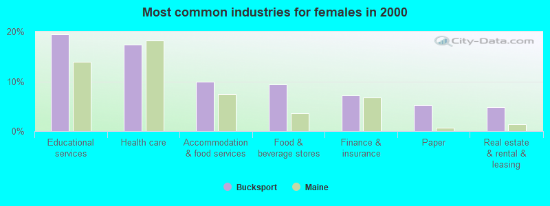
- Educational services (19.5%)
- Health care (17.3%)
- Accommodation & food services (10.0%)
- Food & beverage stores (9.4%)
- Finance & insurance (7.2%)
- Paper (5.3%)
- Real estate & rental & leasing (4.8%)

- Other production occupations, including supervisors (7.0%)
- Preschool, kindergarten, elementary, and middle school teachers (5.2%)
- Other office and administrative support workers, including supervisors (4.7%)
- Other sales and related occupations, including supervisors (4.1%)
- Electrical equipment mechanics and other installation, maintenance, and repair workers, including supervisors (3.7%)
- Registered nurses (3.7%)
- Secretaries and administrative assistants (3.3%)
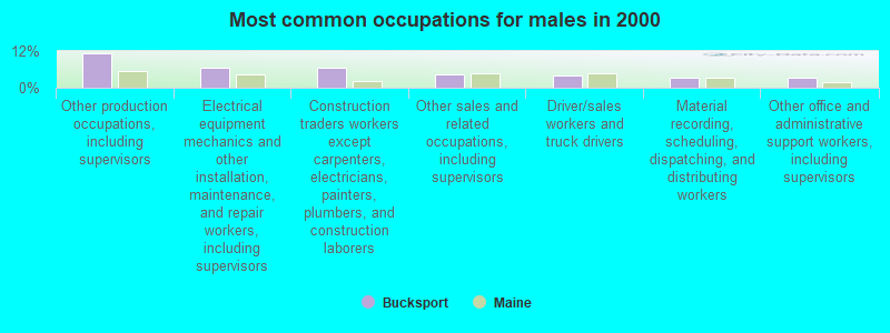
- Other production occupations, including supervisors (11.1%)
- Electrical equipment mechanics and other installation, maintenance, and repair workers, including supervisors (6.5%)
- Construction traders workers except carpenters, electricians, painters, plumbers, and construction laborers (6.5%)
- Other sales and related occupations, including supervisors (4.2%)
- Driver/sales workers and truck drivers (4.1%)
- Material recording, scheduling, dispatching, and distributing workers (3.5%)
- Other office and administrative support workers, including supervisors (3.3%)

- Preschool, kindergarten, elementary, and middle school teachers (8.3%)
- Other office and administrative support workers, including supervisors (6.2%)
- Secretaries and administrative assistants (5.9%)
- Cashiers (5.4%)
- Bookkeeping, accounting, and auditing clerks (4.7%)
- Registered nurses (4.5%)
- Health technologists and technicians (4.4%)
Average climate in Bucksport, Maine
Based on data reported by over 4,000 weather stations


|
|


(lower is better)
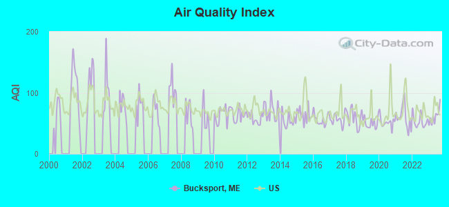
Air Quality Index (AQI) level in 2023 was 61.1. This is about average.
| City: | 61.1 |
| U.S.: | 72.6 |
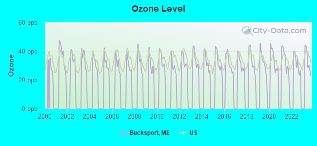
Ozone [ppb] level in 2023 was 33.6. This is about average. Closest monitor was 10.2 miles away from the city center.
| City: | 33.6 |
| U.S.: | 33.3 |
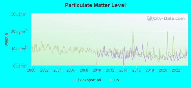
Particulate Matter (PM2.5) [µg/m3] level in 2023 was 5.62. This is significantly better than average. Closest monitor was 15.3 miles away from the city center.
| City: | 5.62 |
| U.S.: | 8.11 |
Earthquake activity:
Bucksport-area historical earthquake activity is significantly above Maine state average. It is 79% smaller than the overall U.S. average.On 10/16/2012 at 23:12:25, a magnitude 4.7 (4.7 ML, Depth: 10.0 mi, Class: Light, Intensity: IV - V) earthquake occurred 114.7 miles away from Bucksport center
On 4/20/2002 at 10:50:47, a magnitude 5.3 (5.3 ML, Depth: 3.0 mi, Class: Moderate, Intensity: VI - VII) earthquake occurred 241.7 miles away from Bucksport center
On 4/20/2002 at 10:50:47, a magnitude 5.2 (5.2 MB, 4.2 MS, 5.2 MW, 5.0 MW) earthquake occurred 242.8 miles away from the city center
On 1/19/1982 at 00:14:42, a magnitude 4.7 (4.5 MB, 4.7 MD, 4.5 LG) earthquake occurred 158.2 miles away from Bucksport center
On 10/7/1983 at 10:18:46, a magnitude 5.3 (5.1 MB, 5.3 LG, 5.1 ML) earthquake occurred 278.1 miles away from the city center
On 2/26/1999 at 03:38:43, a magnitude 3.8 (3.8 LG, Depth: 2.0 mi, Class: Light, Intensity: II - III) earthquake occurred 36.4 miles away from Bucksport center
Magnitude types: regional Lg-wave magnitude (LG), body-wave magnitude (MB), duration magnitude (MD), local magnitude (ML), surface-wave magnitude (MS), moment magnitude (MW)
Natural disasters:
The number of natural disasters in Hancock County (18) is near the US average (15).Major Disasters (Presidential) Declared: 11
Emergencies Declared: 6
Causes of natural disasters: Floods: 9, Storms: 8, Snows: 5, Blizzard: 1, Heavy Rain: 1, Hurricane: 1, Ice Storm: 1, Landslide: 1, Snowfall: 1, Wind: 1, Winter Storm: 1, Other: 2 (Note: some incidents may be assigned to more than one category).

Hospitals and medical centers near Bucksport:
- KINDRED TRANSITIONAL CARE AND REHAB-BREWER (Nursing Home, about 15 miles away; BREWER, ME)
- HARBOR HILL CENTER (Nursing Home, about 15 miles away; BELFAST, ME)
- BRADBURY MANOR (Nursing Home, about 15 miles away; BELFAST, ME)
- ST JOSEPH HOSPICE (Hospital, about 15 miles away; BANGOR, ME)
- ST JOSEPH HOSPITAL Acute Care Hospitals (about 15 miles away; BANGOR, ME)
- THE COMMONS AT TALL PINES (Nursing Home, about 16 miles away; BELFAST, ME)
- AMEDISYS HOME HEALTH OF BANGOR (Home Health Center, about 16 miles away; BANGOR, ME)
Colleges/universities with over 2000 students nearest to Bucksport:
- Husson University (about 18 miles; Bangor, ME; Full-time enrollment: 2,421)
- University of Maine (about 23 miles; Orono, ME; FT enrollment: 8,931)
- University of Maine at Augusta (about 53 miles; Augusta, ME; FT enrollment: 3,204)
- University of Maine at Farmington (about 67 miles; Farmington, ME; FT enrollment: 2,036)
- Southern Maine Community College (about 96 miles; South Portland, ME; FT enrollment: 4,666)
- University of Southern Maine (about 98 miles; Portland, ME; FT enrollment: 6,647)
- Saint Joseph's College of Maine (about 99 miles; Standish, ME; FT enrollment: 2,010)
Public high school in Bucksport:
- BUCKSPORT HIGH SCHOOL (Students: 481, Location: 102 BROADWAY, Grades: 9-12)
Private high schools in Bucksport:
Public elementary/middle schools in Bucksport:
- BUCKSPORT MIDDLE SCHOOL (Students: 311, Location: 100 MILES LANE, Grades: 5-8)
- MILES LANE SCHOOL (Location: 52 MILES LN, Grades: 1-4)
Points of interest:
Notable locations in Bucksport: Bucksport Public Safety (A), Buck Memorial Library (B), Bucksport Historical Society Museum (C). Display/hide their locations on the map
Churches in Bucksport include: Elm Street Congregational Church (A), Evangelical Baptist Church (B). Display/hide their locations on the map
Cemeteries: Silver Lake Cemetery (1), Buck Cemetery (2). Display/hide their locations on the map
Reservoir: Silver Lake (A). Display/hide its location on the map
Tourist attraction: Bucksport Bay Area Chamber of Commerce (52 State Route 46) (1). Display/hide its approximate location on the map
Hotels: Best Western-Jed Prouty Motor Inn (52 Main) (1), Best Western Jed Prouty Motor (64 Main Street) (2). Display/hide their approximate locations on the map
Birthplace of: Edward Winslow Hinks - General.
Drinking water stations with addresses in Bucksport and their reported violations in the past:
PENOBSCOT NARROWS OBSERVATORY (Population served: 265, Groundwater):Past monitoring violations:BUCKSPORT GOLF CLUB (Population served: 200, Groundwater):
- 2 routine major monitoring violations
- One regular monitoring violation
Past monitoring violations:FORT KNOX (Population served: 200, Groundwater):
- 16 routine major monitoring violations
- 5 regular monitoring violations
Past monitoring violations:WANDERIN MOOSE LLC (Population served: 50, Groundwater):
- One routine major monitoring violation
- 2 regular monitoring violations
Past health violations:BUCKSPORT AREA CHILD CARE CENTER (Population served: 25, Groundwater):Past monitoring violations:
- MCL, Monthly (TCR) - In MAY-2007, Contaminant: Coliform. Follow-up actions: St Public Notif requested (MAY-29-2007), St Violation/Reminder Notice (MAY-29-2007), St Public Notif received (JUN-08-2007), St Compliance achieved (MAY-11-2009)
- One routine major monitoring violation
Past monitoring violations:
- One routine major monitoring violation
Drinking water stations with addresses in Bucksport that have no violations reported:
- SHERWOOD FOREST MHP (Population served: 68, Primary Water Source Type: Groundwater)
| This place: | 2.2 people |
| Maine: | 2.3 people |
| This place: | 59.3% |
| Whole state: | 62.9% |
| This place: | 8.3% |
| Whole state: | 9.4% |
Likely homosexual households (counted as self-reported same-sex unmarried-partner households)
- Lesbian couples: 0.4% of all households
- Gay men: 0.1% of all households
6 people in residential treatment centers for adults in 2010
34 people in other group homes in 2000
5 people in homes for the mentally ill in 2000
Banks with branches in Bucksport (2011 data):
- The Camden National Bank: Bucksport Branch at 382 Main Street, branch established on 1961/10/09. Info updated 2008/02/27: Bank assets: $2,266.8 mil, Deposits: $1,604.6 mil, headquarters in Camden, ME, positive income, Commercial Lending Specialization, 39 total offices, Holding Company: Camden National Corporation
- Bangor Savings Bank: Bucksport Branch at 89 Main Street, branch established on 1933/11/20. Info updated 2008/12/02: Bank assets: $2,556.3 mil, Deposits: $1,940.3 mil, headquarters in Bangor, ME, positive income, Commercial Lending Specialization, 58 total offices, Holding Company: Bangor Bancorp, Mhc
For population 15 years and over in Bucksport:
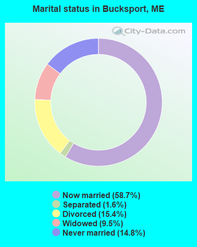
- Never married: 14.8%
- Now married: 58.7%
- Separated: 1.6%
- Widowed: 9.5%
- Divorced: 15.4%
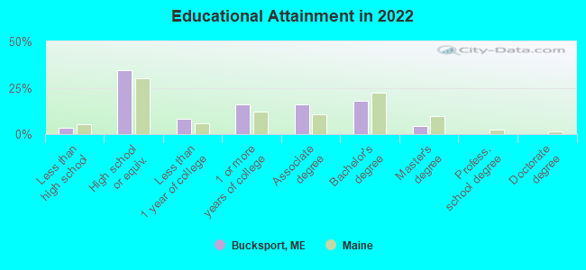
For population 25 years and over in Bucksport:
- High school or higher: 96.0%
- Bachelor's degree or higher: 20.8%
- Graduate or professional degree: 3.9%
- Unemployed: 9.2%
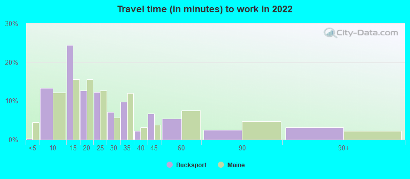
- Mean travel time to work (commute): 29.7 minutes

| Here: | 7.2 |
| Maine average: | 10.3 |


Graphs represent county-level data. Detailed 2008 Election Results
Religion statistics for Bucksport, ME (based on Hancock County data)


| Religion | Adherents | Congregations |
|---|---|---|
| Mainline Protestant | 4,691 | 58 |
| Catholic | 2,523 | 9 |
| Evangelical Protestant | 1,288 | 23 |
| Other | 820 | 11 |
| None | 45,096 | - |
Food Environment Statistics:
| Here: | 6.01 / 10,000 pop. |
| Maine: | 2.80 / 10,000 pop. |
| Hancock County: | 1.69 / 10,000 pop. |
| Maine: | 2.20 / 10,000 pop. |
| Hancock County: | 4.89 / 10,000 pop. |
| Maine: | 5.75 / 10,000 pop. |
| Hancock County: | 21.61 / 10,000 pop. |
| State: | 11.02 / 10,000 pop. |
| Hancock County: | 7.4% |
| State: | 8.2% |
| This county: | 25.4% |
| Maine: | 25.0% |
Health and Nutrition:
| Bucksport: | 46.6% |
| State: | 53.9% |
| Bucksport: | 42.1% |
| Maine: | 52.9% |
| Bucksport: | 29.1 |
| State: | 28.3 |
| Bucksport: | 28.0% |
| Maine: | 19.9% |
| Bucksport: | 10.7% |
| Maine: | 8.7% |
| This city: | 6.8 |
| State: | 6.9 |
| Bucksport: | 35.5% |
| Maine: | 34.3% |
| Bucksport: | 52.4% |
| Maine: | 60.5% |
| Bucksport: | 76.5% |
| Maine: | 79.6% |
More about Health and Nutrition of Bucksport, ME Residents
| Businesses in Bucksport, ME | ||||
| Name | Count | Name | Count | |
|---|---|---|---|---|
| Circle K | 1 | Rite Aid | 1 | |
| Dunkin Donuts | 1 | Subway | 1 | |
| FedEx | 1 | True Value | 1 | |
| H&R Block | 1 | U-Haul | 1 | |
| McDonald's | 1 | UPS | 1 | |
| RadioShack | 1 | |||
Strongest AM radio stations in Bucksport:
- WABI (910 AM; 5 kW; BANGOR, ME; Owner: CLEAR CHANNEL BROADCASTING LICENSES, INC.)
- WZON (620 AM; 5 kW; BANGOR, ME; Owner: THE ZONE CORPORATION)
- WDEA (1370 AM; 5 kW; ELLSWORTH, ME; Owner: CUMULUS LICENSING CORP.)
- WSKW (1160 AM; 10 kW; SKOWHEGAN, ME; Owner: MOUNTAIN WIRELESS, INCORPORATED)
- WRKO (680 AM; 50 kW; BOSTON, MA; Owner: ENTERCOM BOSTON LICENSE, LLC)
- WNZS (1340 AM; 1 kW; VEAZIE, ME; Owner: WATERFRONT COMMUNICATIONS INC.)
- WTME (780 AM; 10 kW; RUMFORD, ME; Owner: MOUNTAIN VALLEY BROADCASTING, INC.)
- WEEI (850 AM; 50 kW; BOSTON, MA; Owner: ENTERCOM BOSTON LICENSE, LLC)
- WBZ (1030 AM; 50 kW; BOSTON, MA; Owner: INFINITY BROADCASTING OPERATIONS, INC.)
- WFAU (1280 AM; 5 kW; GARDINER, ME; Owner: CAPSTAR TX LIMITED PARTNERSHIP)
- WCRN (830 AM; 50 kW; WORCESTER, MA; Owner: CARTER BROADCASTING CORPORATION)
- WNNZ (640 AM; 50 kW; WESTFIELD, MA; Owner: CLEAR CHANNEL BROADCASTING LICENSES, INC.)
- WMTW (870 AM; 10 kW; GORHAM, ME; Owner: RADIO PARTNERS OF MAINE, L.P.)
Strongest FM radio stations in Bucksport:
- WBFB (104.7 FM; BELFAST, ME; Owner: CLEAR CHANNEL BROADCASTING LICENSES, INC.)
- WKIT-FM (100.3 FM; BREWER, ME; Owner: THE ZONE CORPORATION)
- WWMJ (95.7 FM; ELLSWORTH, ME; Owner: CUMULUS LICENSING CORP.)
- WFZX (101.7 FM; SEARSPORT, ME; Owner: CLEAR CHANNEL BROADCASTING LICENSES, INC.)
- WWBX (97.1 FM; BANGOR, ME; Owner: CLEAR CHANNEL BROADCASTING LICENSES, INC.)
- WERU-FM (89.9 FM; BLUE HILL, ME; Owner: SALT POND COMMUNITY B/C COMPANY)
- WMEH (90.9 FM; BANGOR, ME; Owner: MAINE PUBLIC BROADCASTING CORPORATION)
- WEZQ (92.9 FM; BANGOR, ME; Owner: CUMULUS LICENSING CORP.)
- WMEP (90.5 FM; CAMDEN, ME; Owner: MAINE PUBLIC BROADCASTING CORP.)
- WQSS (102.5 FM; CAMDEN, ME; Owner: CLEAR CHANNEL BROADCASTING LICENSES, INC.)
- WHCF (88.5 FM; BANGOR, ME; Owner: BANGOR BAPTIST CHURCH)
- WVOM (103.9 FM; HOWLAND, ME; Owner: CLEAR CHANNEL BROADCASTING LICENSES, INC.)
- WNSX (97.7 FM; WINTER HARBOR, ME; Owner: CLEAR CHANNEL BROADCASTING LICENSES, INC.)
- WQCB (106.5 FM; BREWER, ME; Owner: CUMULUS LICENSING CORP.)
- WLKE (99.1 FM; BAR HARBOR, ME; Owner: CLEAR CHANNEL BROADCASTING LICENSES, INC.)
- WMCM (103.3 FM; ROCKLAND, ME; Owner: CLEAR CHANNEL BROADCASTING LICENSES, INC.)
- WBZN (107.3 FM; OLD TOWN, ME; Owner: CUMULUS LICENSING CORP.)
- WBYA (105.5 FM; ISLESBORO, ME; Owner: MARINER BROADCASTING LIMTED PARTNERSHIP)
TV broadcast stations around Bucksport:
- WCKD-LP (Channel 30; BANGOR/DEDHAM, ME; Owner: J. MCLEOD, ME FAMILY B/CING., INC.)
- WABI-TV (Channel 5; BANGOR, ME; Owner: COMMUNITY BROADCASTING SERVICE)
- WLBZ (Channel 2; BANGOR, ME; Owner: PACIFIC AND SOUTHERN COMPANY, INC.)
- WBGR-LP (Channel 33; BANGOR/DEDHAM, ME; Owner: MAINE FAMILY BROADCASTING, INC.)
- WMEB-TV (Channel 12; ORONO, ME; Owner: MAINE PUBLIC BROADCASTING CORPORATION)
- W36CK (Channel 36; BANGOR, ME; Owner: TRINITY BROADCASTING NETWORK)
- W66CL (Channel 66; BANGOR, ME; Owner: MS COMMUNICATIONS, LLC)
- WBAN-LP (Channel 9; BANGOR, ME; Owner: BANGOR MEDIA GROUP, LLC)
- National Bridge Inventory (NBI) Statistics
- 10Number of bridges
- 230ft / 69.6mTotal length
- 59,499Total average daily traffic
- 4,601Total average daily truck traffic
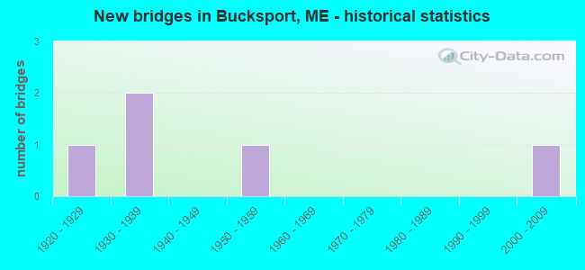
- New bridges - historical statistics
- 11920-1929
- 21930-1939
- 11950-1959
- 12000-2009
FCC Registered Cell Phone Towers:
2 (See the full list of FCC Registered Cell Phone Towers in Bucksport)FCC Registered Antenna Towers:
26 (See the full list of FCC Registered Antenna Towers)FCC Registered Broadcast Land Mobile Towers:
2- Co Gen River Rd (Lat: 44.570639 Lon: -68.805028), Type: Building, Structure height: 5 m, Overall height: 6 m, Call Sign: WPKM525,
Assigned Frequencies: 461.100 MHz, Grant Date: 04/05/2012, Expiration Date: 04/23/2022, Cancellation Date: 02/24/2022, Certifier: Robert A Ackley, Registrant: Kirkland & Ellis LLP, 1301 Pennsylvania Ave., N.W., Washington, DC 20004, Phone: (202) 389-3015, Fax: (717) 337-9157, Email:
- Lat: 44.573611 Lon: -68.794444, Call Sign: WRJP554,
Assigned Frequencies: 158.175 MHz, 159.660 MHz, 159.735 MHz, 159.870 MHz, 160.012 MHz, Grant Date: 10/06/2020, Expiration Date: 10/06/2030, Certifier: James Morrill, Registrant: Browns Communications, 162 Bangor Rd, Ellsworth, ME 04605, Phone: (207) 667-2254, Email:
FCC Registered Microwave Towers:
3- MT WALDO, 3.5 Nm W (Lat: 44.580472 Lon: -68.895222), Type: Gtower, Structure height: 91.4 m, Overall height: 99.1 m, Call Sign: WMW970,
Assigned Frequencies: 6315.84 MHz, 11075.0 MHz, Grant Date: 03/16/2021, Expiration Date: 02/01/2031, Registrant: Wilkinson Barker Knauer, LLP, 1800 M Street Nw, Suite 800n, Washington, DC 20036, Phone: (202) 383-3420, Fax: (202) 783-5851, Email:
- HEAGAN, 3.9km W Of Bucksport 1.8km N Of State Rte 17 (Lat: 44.576111 Lon: -68.847500), Type: Tower, Structure height: 91.4 m, Overall height: 99 m, Call Sign: WQBE845,
Assigned Frequencies: 10552.5 MHz, Grant Date: 09/03/2014, Expiration Date: 09/28/2024, Cancellation Date: 08/04/2015, Certifier: John E Rooney, Registrant: Holland & Knight LLP, 800 17th Street, N.W., Suite #1100, Washington, DC 20006-3906, Phone: (202) 955-3000, Fax: (202) 955-5564, Email:
- 4BG0488A, 92 Church Rd (Lat: 44.637472 Lon: -68.710694), Type: Ltower, Structure height: 58 m, Call Sign: WRDT525,
Assigned Frequencies: 11245.0 MHz, 11245.0 MHz, 11245.0 MHz, 11245.0 MHz, 11245.0 MHz, 11245.0 MHz, 11245.0 MHz, 11245.0 MHz, 11245.0 MHz, 11245.0 MHz... (+22 more), Grant Date: 07/16/2019, Expiration Date: 07/16/2029, Certifier: David Werblow, Registrant: T-Mobile Usa, Inc., 12920 Se 38th Street, Bellevue, WA 98006, Phone: (425) 383-8401, Fax: (425) 383-4040, Email:
FCC Registered Paging Towers:
1- Mt Waldo, 3.5 Miles West Of (Lat: 44.580556 Lon: -68.895278), Type: Tower, Structure height: 99 m, Call Sign: KKB618,
Assigned Frequencies: 152.630 MHz, Grant Date: 03/19/2019, Expiration Date: 04/01/2029, Certifier: Gerard E Ouellette, Registrant: Atlantic Communications, Inc., 40 Freedom Parkway, Hermon, Maine 04401, Bangor, ME 04402-0596, Phone: (207) 848-7590, Fax: (207) 974-3151, Email:
FCC Registered Maritime Coast & Aviation Ground Towers:
2- 15 River Road (Lat: 44.573417 Lon: -68.801139), Type: Building, Overall height: 5 m, Call Sign: WHX462,
Assigned Frequencies: 156.450 MHz, 156.500 MHz, 156.600 MHz, 156.800 MHz, Grant Date: 09/30/1997, Expiration Date: 09/16/2002, Cancellation Date: 12/22/2002, Registrant: Sprague Energy Corporation, State Rd 15 River Rd, Bucksport, ME 04974
- 382 Mainst (Lat: 44.572306 Lon: -68.786972), Type: Building, Overall height: 4 m, Call Sign: WHX638, Licensee ID: L00008279,
Assigned Frequencies: 156.450 MHz, 156.800 MHz, 156.900 MHz, Grant Date: 10/18/2002, Expiration Date: 11/05/2012, Cancellation Date: 01/05/2013, Registrant: Port Harbor Marine Inc, 610 Wilson St, Brewer, ME 04412
FCC Registered Amateur Radio Licenses:
25 (See the full list of FCC Registered Amateur Radio Licenses in Bucksport)FAA Registered Aircraft:
1- Aircraft: LUSCOMBE 8A (Category: Land, Seats: 2, Weight: Up to 12,499 Pounds, Speed: 86 mph), Engine: CONT MOTOR A&C65 SERIES (65 HP) (Reciprocating)
N-Number: 45411, N45411, N-45411, Serial Number: 1938, Year manufactured: 1945, Airworthiness Date: 08/09/1963, Certificate Issue Date: 10/12/2001
Registrant (Individual): Robert M Sikkel, Po Box 1001, Bucksport, ME 04416
2003 - 2018 National Fire Incident Reporting System (NFIRS) incidents
- Fire incident types reported to NFIRS in Bucksport, ME
- 26162.1%Structure Fires
- 8821.0%Outside Fires
- 4611.0%Mobile Property/Vehicle Fires
- 256.0%Other
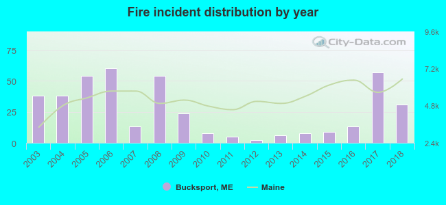 According to the data from the years 2003 - 2018 the average number of fires per year is 26. The highest number of fire incidents - 60 took place in 2006, and the least - 2 in 2012. The data has a declining trend.
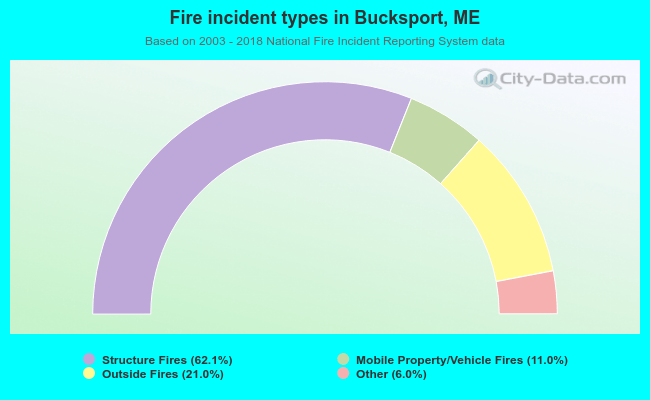 When looking into fire subcategories, the most reports belonged to: Structure Fires (62.1%), and Outside Fires (21.0%).
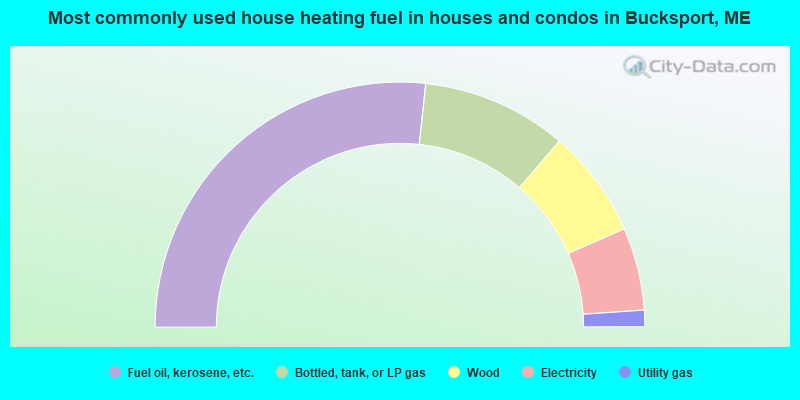
- 53.3%Fuel oil, kerosene, etc.
- 19.2%Bottled, tank, or LP gas
- 14.3%Wood
- 10.9%Electricity
- 2.2%Utility gas
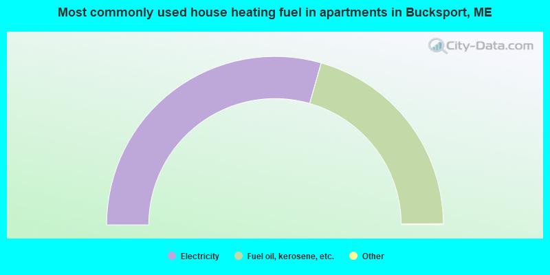
- 59.0%Electricity
- 41.0%Fuel oil, kerosene, etc.
Bucksport compared to Maine state average:
- Black race population percentage significantly below state average.
- Hispanic race population percentage above state average.
- Foreign-born population percentage significantly below state average.
- Length of stay since moving in significantly above state average.
- Number of college students below state average.
Bucksport on our top lists:
- #86 on the list of "Top 101 cities with the largest percentage of people in other group homes (population 1,000+)"
- #3 on the list of "Top 101 counties with the lowest Particulate Matter (PM10) Annual air pollution readings in 2012 (µg/m3)"
- #18 on the list of "Top 101 counties with the lowest Particulate Matter (PM2.5) Annual air pollution readings in 2012 (µg/m3)"
- #30 on the list of "Top 101 counties with the lowest Sulfur Oxides Annual air pollution readings in 2012 (µg/m3)"
- #60 on the list of "Top 101 counties with the highest carbon monoxide air pollution readings in 2012 (ppm)"
- #83 on the list of "Top 101 counties with the lowest total withdrawal of fresh water for public supply (pop. 50,000+)"

|
Total of 2 patent applications in 2008-2024.