Bridge Statistics for Buffalo, Wyoming (WY)
Condition, Traffic, Stress, Structural Evaluation, Project Costs
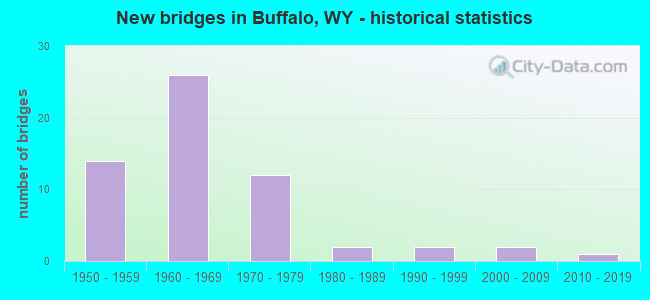
- New bridges - historical statistics
- 141950-1959
- 261960-1969
- 121970-1979
- 21980-1989
- 21990-1999
- 22000-2009
- 12010-2019
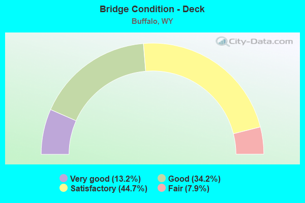
- Bridge Condition - Deck
- 13.2%Very good
- 34.2%Good
- 44.7%Satisfactory
- 7.9%Fair

- Bridge Condition - Superstructure
- 5.3%Very good
- 55.3%Good
- 26.3%Satisfactory
- 10.5%Fair
- 2.6%Serious
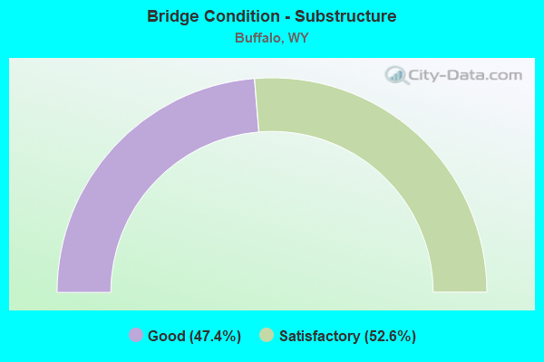
- Bridge Condition - Substructure
- 47.4%Good
- 52.6%Satisfactory
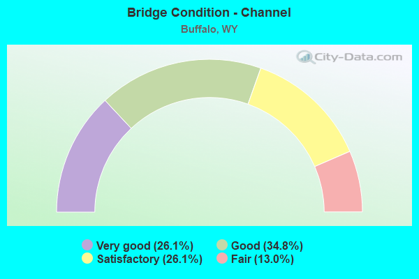
- Bridge Condition - Channel
- 26.1%Very good
- 34.8%Good
- 26.1%Satisfactory
- 13.0%Fair
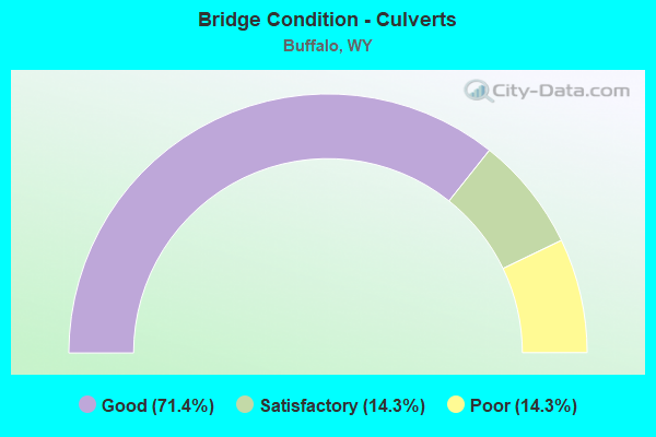
- Bridge Condition - Culverts
- 71.4%Good
- 14.3%Satisfactory
- 14.3%Poor
Find on map >> Show street view
Structure Number: ALL, Location: Wyo 387 Jct - Buffalo (Lat: 44.274747, Lng: -106.682197), Route carried "on" structure: Interstate 25, Year Built: 1969, Status: Open, Structure Length: 7.62m (25.00ft), Average Daily Traffic: 1,687 (year 2021), Truck Traffic: 42%, Average Future Daily Traffic: 2,362 (year 2041), Design Load: HS 20+Mod, Features Intersected: Bull Creek
Minimum Vertical Clearance: 30+ m (98+ ft), Kilometerpoint: 473.120, Lanes on structure: 2, Base Highway Network: Yes (Inventory Route: ML2, Subroute: 2), Owner: State Highway Agency, Approaching Roadway Width: 12.2m (40.0ft), Skew: 13 degrees, Material/Design: Steel continuous, Design/Construction: Stringer/Multi-beam, Number Of Spans In Main Unit: 3, Length of Maximum Span: 29.6m (97.1ft), Curb-To-Curb Width: 12.2m (40.0ft), Out-to-Out Width: 13.0m (42.7ft)
Condition: Deck: Good, Superstructure: Good, Substructure: Good, Channel: Very good, Operating Rating: 49.0 metric tons, Method Used To Determine Operating Rating: Load Factor (LF), Inventory Rating: 29.0 metric tons, Method Used To Determine Inventory Rating: Load Factor (LF), Structural Evaluation: Better than present minimum criteria, Deck Geometry: Better than present minimum criteria, Waterway Adequacy: Equal to present desirable criteria, Approach Roadway Alignment: Equal to present desirable criteria, Designated Inspection Frequency: Every 24 months, Inspection Date: May 2020, Deck Structure Type: Concrete Cast-file-Place, Wearing Surface/Protective System: Wearing Surface: Latex Concrete
Find on map >> Show street view
Structure Number: ALM, Location: Wyo 387 Jct - Buffalo (Lat: 44.274600, Lng: -106.682417), Route carried "on" structure: Interstate 25, Year Built: 1969, Status: Open, Structure Length: 7.62m (25.00ft), Average Daily Traffic: 1,616 (year 2021), Truck Traffic: 20%, Average Future Daily Traffic: 2,262 (year 2041), Design Load: HS 20+Mod, Features Intersected: Bull Creek
Minimum Vertical Clearance: 30+ m (98+ ft), Kilometerpoint: 473.146, Lanes on structure: 2, Base Highway Network: Yes (Inventory Route: ML2, Subroute: 2), Owner: State Highway Agency, Approaching Roadway Width: 12.2m (40.0ft), Skew: 13 degrees, Material/Design: Steel continuous, Design/Construction: Stringer/Multi-beam, Number Of Spans In Main Unit: 3, Length of Maximum Span: 29.6m (97.1ft), Curb-To-Curb Width: 12.2m (40.0ft), Out-to-Out Width: 13.0m (42.7ft)
Condition: Deck: Good, Superstructure: Good, Substructure: Good, Channel: Very good, Operating Rating: 49.0 metric tons, Method Used To Determine Operating Rating: Load Factor (LF), Inventory Rating: 29.0 metric tons, Method Used To Determine Inventory Rating: Load Factor (LF), Structural Evaluation: Better than present minimum criteria, Deck Geometry: Better than present minimum criteria, Waterway Adequacy: Equal to present desirable criteria, Approach Roadway Alignment: Equal to present desirable criteria, Designated Inspection Frequency: Every 24 months, Inspection Date: May 2020, Deck Structure Type: Concrete Cast-file-Place, Wearing Surface/Protective System: Wearing Surface: Latex Concrete
Find on map >> Show street view
Structure Number: ALN, Location: WYO 387 Jct - Buffalo (Lat: 44.281158, Lng: -106.683450), Route carried "on" structure: Interstate 25, Year Built: 1971, Status: Open, Structure Length: 4.08m (13.39ft), Average Daily Traffic: 1,687 (year 2021), Truck Traffic: 42%, Average Future Daily Traffic: 2,362 (year 2041), Design Load: HS 20+Mod, Features Intersected: Machinery Pass
Minimum Vertical Clearance: 30+ m (98+ ft), Kilometerpoint: 473.839, Lanes on structure: 2, Base Highway Network: Yes (Inventory Route: ML2, Subroute: 2), Owner: State Highway Agency, Approaching Roadway Width: 11.6m (38.1ft), Skew: 10 degrees, Material/Design: Concrete continuous, Design/Construction: Tee Beam, Number Of Spans In Main Unit: 3, Length of Maximum Span: 17.1m (56.1ft), Curb-To-Curb Width: 12.2m (40.0ft), Out-to-Out Width: 13.0m (42.7ft)
Condition: Deck: Good, Superstructure: Good, Substructure: Good, Operating Rating: 51.7 metric tons, Method Used To Determine Operating Rating: Load Factor (LF), Inventory Rating: 29.9 metric tons, Method Used To Determine Inventory Rating: Load Factor (LF), Structural Evaluation: Better than present minimum criteria, Deck Geometry: Better than present minimum criteria, Approach Roadway Alignment: Equal to present desirable criteria, Designated Inspection Frequency: Every 24 months, Inspection Date: May 2020, Deck Structure Type: Concrete Cast-file-Place, Wearing Surface/Protective System: Wearing Surface: Latex Concrete
Find on map >> Show street view
Structure Number: ALO, Location: WYO 387 Jct - Buffalo (Lat: 44.281133, Lng: -106.683700), Route carried "on" structure: Interstate 25, Year Built: 1971, Status: Open, Structure Length: 4.08m (13.39ft), Average Daily Traffic: 1,616 (year 2021), Truck Traffic: 20%, Average Future Daily Traffic: 2,262 (year 2041), Design Load: HS 20+Mod, Features Intersected: Machinery Pass
Minimum Vertical Clearance: 30+ m (98+ ft), Kilometerpoint: 473.879, Lanes on structure: 2, Base Highway Network: Yes (Inventory Route: ML2, Subroute: 2), Owner: State Highway Agency, Approaching Roadway Width: 11.6m (38.1ft), Skew: 10 degrees, Material/Design: Concrete continuous, Design/Construction: Tee Beam, Number Of Spans In Main Unit: 3, Length of Maximum Span: 17.1m (56.1ft), Curb-To-Curb Width: 12.2m (40.0ft), Out-to-Out Width: 13.0m (42.7ft)
Condition: Deck: Good, Superstructure: Good, Substructure: Good, Operating Rating: 49.9 metric tons, Method Used To Determine Operating Rating: Load Factor (LF), Inventory Rating: 29.9 metric tons, Method Used To Determine Inventory Rating: Load Factor (LF), Structural Evaluation: Better than present minimum criteria, Deck Geometry: Better than present minimum criteria, Approach Roadway Alignment: Equal to present desirable criteria, Designated Inspection Frequency: Every 24 months, Inspection Date: May 2020, Deck Structure Type: Concrete Cast-file-Place, Wearing Surface/Protective System: Wearing Surface: Latex Concrete
Find on map >> Show street view
Structure Number: ALP, Location: Wyo 387 Jct - Buffalo (Lat: 44.310242, Lng: -106.681706), Route carried "on" structure: Interstate 25, Year Built: 1971, Status: Open, Structure Length: 2.32m (7.61ft), Average Daily Traffic: 1,687 (year 2021), Truck Traffic: 42%, Average Future Daily Traffic: 2,362 (year 2041), Design Load: HS 20+Mod, Features Intersected: Machinery Pass
Minimum Vertical Clearance: 30+ m (98+ ft), Kilometerpoint: 477.074, Lanes on structure: 2, Base Highway Network: Yes (Inventory Route: ML2, Subroute: 2), Owner: State Highway Agency, Approaching Roadway Width: 11.6m (38.1ft), Skew: 10 degrees, Material/Design: Concrete continuous, Design/Construction: Tee Beam, Number Of Spans In Main Unit: 3, Length of Maximum Span: 9.4m (30.8ft), Curb-To-Curb Width: 12.2m (40.0ft), Out-to-Out Width: 13.0m (42.7ft)
Condition: Deck: Good, Superstructure: Good, Substructure: Satisfactory, Operating Rating: 46.3 metric tons, Method Used To Determine Operating Rating: Load Factor (LF), Inventory Rating: 27.2 metric tons, Method Used To Determine Inventory Rating: Load Factor (LF), Structural Evaluation: Equal to present minimum criteria, Deck Geometry: Better than present minimum criteria, Approach Roadway Alignment: Equal to present desirable criteria, Designated Inspection Frequency: Every 24 months, Inspection Date: May 2020, Deck Structure Type: Concrete Cast-file-Place, Wearing Surface/Protective System: Wearing Surface: Latex Concrete
Find on map >> Show street view
Structure Number: ALQ, Location: Wyo 387 Jct - Buffalo (Lat: 44.310247, Lng: -106.681956), Route carried "on" structure: Interstate 25, Year Built: 1971, Status: Open, Structure Length: 2.32m (7.61ft), Average Daily Traffic: 1,616 (year 2021), Truck Traffic: 20%, Average Future Daily Traffic: 2,262 (year 2041), Design Load: HS 20+Mod, Features Intersected: Machinery Pass
Minimum Vertical Clearance: 30+ m (98+ ft), Kilometerpoint: 477.119, Lanes on structure: 2, Base Highway Network: Yes (Inventory Route: ML2, Subroute: 2), Owner: State Highway Agency, Approaching Roadway Width: 11.6m (38.1ft), Skew: 10 degrees, Material/Design: Concrete continuous, Design/Construction: Tee Beam, Number Of Spans In Main Unit: 3, Length of Maximum Span: 9.4m (30.8ft), Curb-To-Curb Width: 12.2m (40.0ft), Out-to-Out Width: 13.0m (42.7ft)
Condition: Deck: Very good, Superstructure: Good, Substructure: Good, Operating Rating: 46.3 metric tons, Method Used To Determine Operating Rating: Load Factor (LF), Inventory Rating: 27.2 metric tons, Method Used To Determine Inventory Rating: Load Factor (LF), Structural Evaluation: Equal to present minimum criteria, Deck Geometry: Better than present minimum criteria, Approach Roadway Alignment: Equal to present desirable criteria, Designated Inspection Frequency: Every 24 months, Inspection Date: May 2020, Deck Structure Type: Concrete Cast-file-Place, Wearing Surface/Protective System: Wearing Surface: Latex Concrete
Find on map >> Show street view
Structure Number: ALR, Location: Buffalo (Lat: 44.335219, Lng: -106.685133), Route carried "on" structure: Interstate 25, Year Built: 1971, Status: Open, Structure Length: 5.00m (16.40ft), Average Daily Traffic: 1,487 (year 2021), Truck Traffic: 47%, Average Future Daily Traffic: 2,082 (year 2041), Design Load: HS 20+Mod, Features Intersected: South Main Street
Minimum Vertical Clearance: 30+ m (98+ ft), Kilometerpoint: 479.877, Lanes on structure: 2, Lanes under structure: 2, Base Highway Network: Yes (Inventory Route: ML2, Subroute: 2), Owner: State Highway Agency, Approaching Roadway Width: 11.6m (38.1ft), Skew: 11 degrees, Material/Design: Concrete continuous, Design/Construction: Tee Beam, Number Of Spans In Main Unit: 3, Length of Maximum Span: 18.9m (62.0ft), Curb-To-Curb Width: 12.2m (40.0ft), Out-to-Out Width: 13.0m (42.7ft)
Condition: Deck: Very good, Superstructure: Satisfactory, Substructure: Satisfactory, Operating Rating: 59.9 metric tons, Method Used To Determine Operating Rating: Load Factor (LF), Inventory Rating: 35.4 metric tons, Method Used To Determine Inventory Rating: Load Factor (LF), Structural Evaluation: Equal to present minimum criteria, Deck Geometry: Better than present minimum criteria, Underclear: Superior to present desirable criteria, Approach Roadway Alignment: Equal to present desirable criteria, Designated Inspection Frequency: Every 24 months, Inspection Date: May 2020, Deck Structure Type: Concrete Cast-file-Place, Wearing Surface/Protective System: Wearing Surface: Latex Concrete
Find on map >> Show street view
Structure Number: ALS, Location: Buffalo (Lat: 44.335272, Lng: -106.685392), Route carried "on" structure: Interstate 25, Year Built: 1971, Status: Open, Structure Length: 5.00m (16.40ft), Average Daily Traffic: 1,427 (year 2021), Truck Traffic: 20%, Average Future Daily Traffic: 1,998 (year 2041), Design Load: HS 20+Mod, Features Intersected: South Main Street
Minimum Vertical Clearance: 30+ m (98+ ft), Kilometerpoint: 479.926, Lanes on structure: 2, Lanes under structure: 2, Base Highway Network: Yes (Inventory Route: ML2, Subroute: 2), Owner: State Highway Agency, Approaching Roadway Width: 11.6m (38.1ft), Skew: 11 degrees, Material/Design: Concrete continuous, Design/Construction: Tee Beam, Number Of Spans In Main Unit: 3, Length of Maximum Span: 18.9m (62.0ft), Curb-To-Curb Width: 12.2m (40.0ft), Out-to-Out Width: 13.0m (42.7ft)
Condition: Deck: Very good, Superstructure: Good, Substructure: Satisfactory, Operating Rating: 60.8 metric tons, Method Used To Determine Operating Rating: Load Factor (LF), Inventory Rating: 36.3 metric tons, Method Used To Determine Inventory Rating: Load Factor (LF), Structural Evaluation: Equal to present minimum criteria, Deck Geometry: Better than present minimum criteria, Underclear: Somewhat better than minimum adequacy, Approach Roadway Alignment: Equal to present desirable criteria, Designated Inspection Frequency: Every 24 months, Inspection Date: May 2020, Deck Structure Type: Concrete Cast-file-Place, Wearing Surface/Protective System: Wearing Surface: Latex Concrete
Find on map >> Show street view
Structure Number: ALT, Location: Buffalo (Lat: 44.343100, Lng: -106.685353), Route carried "on" structure: Interstate 25, Year Built: 1971, Year Reconstructed: 1989, Status: Open, Structure Length: 4.08m (13.39ft), Average Daily Traffic: 1,487 (year 2021), Truck Traffic: 47%, Average Future Daily Traffic: 2,082 (year 2041), Design Load: HS 20+Mod, Features Intersected: Jo CR 8 / Stockyard Road
Minimum Vertical Clearance: 30+ m (98+ ft), Kilometerpoint: 480.753, Lanes on structure: 2, Lanes under structure: 2, Base Highway Network: Yes (Inventory Route: ML2, Subroute: 2), Owner: State Highway Agency, Approaching Roadway Width: 11.6m (38.1ft), Skew: 10 degrees, Material/Design: Concrete continuous, Design/Construction: Tee Beam, Number Of Spans In Main Unit: 3, Length of Maximum Span: 17.1m (56.1ft), Curb-To-Curb Width: 12.2m (40.0ft), Out-to-Out Width: 13.0m (42.7ft)
Condition: Deck: Very good, Superstructure: Very good, Substructure: Good, Operating Rating: 49.9 metric tons, Method Used To Determine Operating Rating: Load Factor (LF), Inventory Rating: 29.9 metric tons, Method Used To Determine Inventory Rating: Load Factor (LF), Structural Evaluation: Better than present minimum criteria, Deck Geometry: Better than present minimum criteria, Underclear: Equal to present minimum criteria, Approach Roadway Alignment: Equal to present desirable criteria, Designated Inspection Frequency: Every 24 months, Inspection Date: May 2020, Deck Structure Type: Concrete Cast-file-Place, Wearing Surface/Protective System: Wearing Surface: Latex Concrete
Find on map >> Show street view
Structure Number: ALU, Location: Buffalo (Lat: 44.343092, Lng: -106.685603), Route carried "on" structure: Interstate 25, Year Built: 1971, Status: Open, Structure Length: 4.08m (13.39ft), Average Daily Traffic: 1,427 (year 2021), Truck Traffic: 20%, Average Future Daily Traffic: 1,998 (year 2041), Design Load: HS 20+Mod, Features Intersected: Jo CR 8 / Stockyard Road
Minimum Vertical Clearance: 30+ m (98+ ft), Kilometerpoint: 480.795, Lanes on structure: 2, Lanes under structure: 2, Base Highway Network: Yes (Inventory Route: ML2, Subroute: 2), Owner: State Highway Agency, Approaching Roadway Width: 11.6m (38.1ft), Skew: 10 degrees, Material/Design: Concrete continuous, Design/Construction: Tee Beam, Number Of Spans In Main Unit: 3, Length of Maximum Span: 17.1m (56.1ft), Curb-To-Curb Width: 12.2m (40.0ft), Out-to-Out Width: 13.0m (42.7ft)
Condition: Deck: Good, Superstructure: Good, Substructure: Good, Operating Rating: 49.9 metric tons, Method Used To Determine Operating Rating: Load Factor (LF), Inventory Rating: 29.9 metric tons, Method Used To Determine Inventory Rating: Load Factor (LF), Structural Evaluation: Better than present minimum criteria, Deck Geometry: Better than present minimum criteria, Underclear: High priority of corrective action, Approach Roadway Alignment: Equal to present desirable criteria, Designated Inspection Frequency: Every 24 months, Inspection Date: May 2020, Deck Structure Type: Concrete Cast-file-Place, Wearing Surface/Protective System: Wearing Surface: Latex Concrete
Find on map >> Show street view
Structure Number: ALV, Location: Buffalo (Lat: 44.351956, Lng: -106.686164), Route carried "on" structure: Interstate 25, Year Built: 1963, Status: Open, Structure Length: 0.63m (2.07ft), Average Daily Traffic: 1,581 (year 2021), Truck Traffic: 45%, Average Future Daily Traffic: 2,213 (year 2041), Design Load: HS 20+Mod, Features Intersected: Clear Creek
Minimum Vertical Clearance: 30+ m (98+ ft), Kilometerpoint: 481.741, Lanes on structure: 6, Base Highway Network: Yes (Inventory Route: ML2, Subroute: 2), Owner: State Highway Agency, Approaching Roadway Width: 38.4m (126.0ft), Skew: 20 degrees, Material/Design: Concrete continuous, Design/Construction: Culvert, Number Of Spans In Main Unit: 2, Length of Maximum Span: 3.0m (9.8ft)
Condition: Channel: Good, Culverts: Good, Operating Rating: 32.7 metric tons, Method Used To Determine Operating Rating: Field evaluation and documented engineering judgment, Inventory Rating: 32.7 metric tons, Method Used To Determine Inventory Rating: Field evaluation and documented engineering judgment, Structural Evaluation: Better than present minimum criteria, Waterway Adequacy: Equal to present desirable criteria, Approach Roadway Alignment: Equal to present desirable criteria, Designated Inspection Frequency: Every 24 months, Inspection Date: May 2020
Find on map >> Show street view
Structure Number: ALW, Location: Buffalo (Lat: 44.354033, Lng: -106.686592), Route carried "on" structure: Interstate 25, Year Built: 1963, Status: Open, Structure Length: 3.66m (12.01ft), Average Daily Traffic: 1,581 (year 2021), Truck Traffic: 45%, Average Future Daily Traffic: 2,213 (year 2041), Design Load: HS 20+Mod, Features Intersected: East Hart Street
Minimum Vertical Clearance: 30+ m (98+ ft), Kilometerpoint: 481.974, Lanes on structure: 2, Lanes under structure: 3, Base Highway Network: Yes (Inventory Route: ML2, Subroute: 2), Owner: State Highway Agency, Approaching Roadway Width: 11.6m (38.1ft), Skew: 10 degrees, Material/Design: Steel continuous, Design/Construction: Stringer/Multi-beam, Number Of Spans In Main Unit: 3, Length of Maximum Span: 15.2m (49.9ft), Curb-To-Curb Width: 11.6m (38.1ft), Out-to-Out Width: 12.5m (41.0ft)
Condition: Deck: Good, Superstructure: Good, Substructure: Good, Operating Rating: 54.4 metric tons, Method Used To Determine Operating Rating: Load Factor (LF), Inventory Rating: 32.7 metric tons, Method Used To Determine Inventory Rating: Load Factor (LF), Structural Evaluation: Better than present minimum criteria, Deck Geometry: Equal to present minimum criteria, Underclear: High priority of corrective action, Approach Roadway Alignment: Equal to present desirable criteria, Designated Inspection Frequency: Every 24 months, Inspection Date: May 2020, Deck Structure Type: Concrete Cast-file-Place, Wearing Surface/Protective System: Wearing Surface: Epoxy Overlay
Find on map >> Show street view
Structure Number: ALX, Location: Buffalo (Lat: 44.354028, Lng: -106.686864), Route carried "on" structure: Interstate 25, Year Built: 1963, Status: Open, Structure Length: 3.66m (12.01ft), Average Daily Traffic: 1,523 (year 2021), Truck Traffic: 20%, Average Future Daily Traffic: 2,132 (year 2041), Design Load: HS 20+Mod, Features Intersected: East Hart Street
Minimum Vertical Clearance: 30+ m (98+ ft), Kilometerpoint: 482.016, Lanes on structure: 2, Lanes under structure: 3, Base Highway Network: Yes (Inventory Route: ML2, Subroute: 2), Owner: State Highway Agency, Approaching Roadway Width: 11.6m (38.1ft), Skew: 10 degrees, Material/Design: Steel continuous, Design/Construction: Stringer/Multi-beam, Number Of Spans In Main Unit: 3, Length of Maximum Span: 15.2m (49.9ft), Curb-To-Curb Width: 11.6m (38.1ft), Out-to-Out Width: 12.5m (41.0ft)
Condition: Deck: Satisfactory, Superstructure: Satisfactory, Substructure: Good, Operating Rating: 53.5 metric tons, Method Used To Determine Operating Rating: Load Factor (LF), Inventory Rating: 32.7 metric tons, Method Used To Determine Inventory Rating: Load Factor (LF), Structural Evaluation: Equal to present minimum criteria, Deck Geometry: Equal to present minimum criteria, Underclear: High priority of corrective action, Approach Roadway Alignment: Equal to present desirable criteria, Designated Inspection Frequency: Every 24 months, Inspection Date: May 2020, Deck Structure Type: Concrete Cast-file-Place, Wearing Surface/Protective System: Wearing Surface: Epoxy Overlay
Find on map >> Show street view
Structure Number: ALY, Location: Buffalo (Lat: 44.357439, Lng: -106.687322), Route carried "on" structure: Interstate 25, Year Built: 1963, Status: Open, Structure Length: 2.56m (8.40ft), Average Daily Traffic: 1,581 (year 2021), Truck Traffic: 45%, Average Future Daily Traffic: 2,213 (year 2041), Design Load: HS 20+Mod, Features Intersected: Kings Lane
Minimum Vertical Clearance: 30+ m (98+ ft), Kilometerpoint: 482.357, Lanes on structure: 2, Lanes under structure: 1, Base Highway Network: Yes (Inventory Route: ML2, Subroute: 2), Owner: State Highway Agency, Approaching Roadway Width: 11.6m (38.1ft), Skew: 10 degrees, Material/Design: Concrete continuous, Design/Construction: Slab, Number Of Spans In Main Unit: 3, Length of Maximum Span: 10.7m (35.1ft), Curb-To-Curb Width: 12.8m (42.0ft), Out-to-Out Width: 13.7m (44.9ft)
Condition: Deck: Satisfactory, Superstructure: Satisfactory, Substructure: Satisfactory, Operating Rating: 47.4 metric tons, Method Used To Determine Operating Rating: Load Factor (LF), Inventory Rating: 28.4 metric tons, Method Used To Determine Inventory Rating: Load Factor (LF), Structural Evaluation: Equal to present minimum criteria, Deck Geometry: Equal to present desirable criteria, Underclear: High priority of corrective action, Approach Roadway Alignment: Equal to present desirable criteria, Designated Inspection Frequency: Every 24 months, Inspection Date: May 2020, Deck Structure Type: Concrete Cast-file-Place, Wearing Surface/Protective System: Wearing Surface: Latex Concrete
Find on map >> Show street view
Structure Number: ALZ, Location: Buffalo (Lat: 44.357406, Lng: -106.687592), Route carried "on" structure: Interstate 25, Year Built: 1963, Status: Open, Structure Length: 2.56m (8.40ft), Average Daily Traffic: 1,523 (year 2021), Truck Traffic: 20%, Average Future Daily Traffic: 2,132 (year 2041), Design Load: HS 20+Mod, Features Intersected: Kings Lane
Minimum Vertical Clearance: 30+ m (98+ ft), Kilometerpoint: 482.396, Lanes on structure: 2, Lanes under structure: 1, Base Highway Network: Yes (Inventory Route: ML2, Subroute: 2), Owner: State Highway Agency, Approaching Roadway Width: 11.6m (38.1ft), Skew: 10 degrees, Material/Design: Concrete continuous, Design/Construction: Slab, Number Of Spans In Main Unit: 3, Length of Maximum Span: 10.7m (35.1ft), Curb-To-Curb Width: 12.8m (42.0ft), Out-to-Out Width: 13.7m (44.9ft)
Condition: Deck: Satisfactory, Superstructure: Satisfactory, Substructure: Satisfactory, Operating Rating: 47.4 metric tons, Method Used To Determine Operating Rating: Load Factor (LF), Inventory Rating: 28.4 metric tons, Method Used To Determine Inventory Rating: Load Factor (LF), Structural Evaluation: Equal to present minimum criteria, Deck Geometry: Equal to present desirable criteria, Underclear: High priority of corrective action, Approach Roadway Alignment: Equal to present desirable criteria, Designated Inspection Frequency: Every 24 months, Inspection Date: May 2020, Deck Structure Type: Concrete Cast-file-Place, Wearing Surface/Protective System: Wearing Surface: Latex Concrete
Find on map >> Show street view
Structure Number: AXY, Location: Buffalo (Lat: 44.364339, Lng: -106.696819), Route carried "on" structure: Business US 25, Year Built: 1955, Status: Open, Structure Length: 1.68m (5.51ft), Average Daily Traffic: 2,845 (year 2021), Truck Traffic: 5%, Average Future Daily Traffic: 3,983 (year 2041), Design Load: HS 20, Features Intersected: French Creek, Facility Carried by Structure: I-90 / US 87 Bus
Minimum Vertical Clearance: 30+ m (98+ ft), Kilometerpoint: 483.449, Lanes on structure: 4, Base Highway Network: Yes, Owner: State Highway Agency, Approaching Roadway Width: 20.7m (67.9ft), Material/Design: Concrete, Design/Construction: Frame, Number Of Spans In Main Unit: 1, Length of Maximum Span: 15.2m (49.9ft), Curb or Sidewalk Widths: Left: 1.1m (3.6ft), Right: 1.1m (3.6ft), Curb-To-Curb Width: 22.6m (74.1ft), Out-to-Out Width: 25.2m (82.7ft)
Condition: Deck: Satisfactory, Superstructure: Satisfactory, Substructure: Satisfactory, Channel: Satisfactory, Operating Rating: 62.6 metric tons, Method Used To Determine Operating Rating: Load Factor (LF), Inventory Rating: 37.2 metric tons, Method Used To Determine Inventory Rating: Load Factor (LF), Structural Evaluation: Equal to present minimum criteria, Deck Geometry: Superior to present desirable criteria, Waterway Adequacy: Somewhat better than minimum adequacy, Approach Roadway Alignment: Equal to present desirable criteria, Designated Inspection Frequency: Every 24 months, Inspection Date: May 2020, Deck Structure Type: Concrete Cast-file-Place, Wearing Surface/Protective System: Wearing Surface: Epoxy Overlay
Find on map >> Show street view
Structure Number: BCZ, Location: Sheridan - Buffalo (Lat: 44.405317, Lng: -106.726800), Route carried "on" structure: Interstate 90, Year Built: 1963, Status: Open, Structure Length: 2.56m (8.40ft), Average Daily Traffic: 4,025 (year 2021), Truck Traffic: 17%, Average Future Daily Traffic: 5,635 (year 2041), Design Load: HS 20+Mod, Features Intersected: Jo CR 1 / Rock Creek Rd
Minimum Vertical Clearance: 30+ m (98+ ft), Kilometerpoint: 89.090, Lanes on structure: 2, Lanes under structure: 2, Base Highway Network: Yes (Inventory Route: ML9, Subroute: 1), Owner: State Highway Agency, Approaching Roadway Width: 11.6m (38.1ft), Skew: 10 degrees, Material/Design: Concrete continuous, Design/Construction: Slab, Number Of Spans In Main Unit: 3, Length of Maximum Span: 10.7m (35.1ft), Curb-To-Curb Width: 11.6m (38.1ft), Out-to-Out Width: 12.5m (41.0ft)
Condition: Deck: Fair, Superstructure: Fair, Substructure: Satisfactory, Operating Rating: 44.7 metric tons, Method Used To Determine Operating Rating: Load Factor (LF), Inventory Rating: 26.8 metric tons, Method Used To Determine Inventory Rating: Load Factor (LF), Structural Evaluation: Somewhat better than minimum adequacy, Deck Geometry: Equal to present minimum criteria, Underclear: High priority of corrective action, Approach Roadway Alignment: Equal to present desirable criteria, Designated Inspection Frequency: Every 24 months, Inspection Date: August 2021, Deck Structure Type: Concrete Cast-file-Place, Wearing Surface/Protective System: Wearing Surface: Bituminous
Find on map >> Show street view
Structure Number: BDB, Location: Sheridan - Buffalo (Lat: 44.390344, Lng: -106.714578), Route carried "on" structure: Interstate 90, Year Built: 1963, Status: Open, Structure Length: 0.75m (2.46ft), Average Daily Traffic: 4,025 (year 2021), Truck Traffic: 41%, Average Future Daily Traffic: 5,635 (year 2041), Design Load: HS 20+Mod, Features Intersected: Rock Creek
Minimum Vertical Clearance: 30+ m (98+ ft), Kilometerpoint: 91.016, Lanes on structure: 2, Base Highway Network: Yes (Inventory Route: ML9, Subroute: 1), Owner: State Highway Agency, Approaching Roadway Width: 11.6m (38.1ft), Skew: 10 degrees, Material/Design: Concrete continuous, Design/Construction: Culvert, Number Of Spans In Main Unit: 2, Length of Maximum Span: 3.7m (12.1ft), Curb-To-Curb Width: 11.6m (38.1ft), Out-to-Out Width: 12.5m (41.0ft)
Condition: Channel: Good, Culverts: Good, Operating Rating: 51.6 metric tons, Method Used To Determine Operating Rating: Load Factor (LF), Inventory Rating: 31.0 metric tons, Method Used To Determine Inventory Rating: Load Factor (LF), Structural Evaluation: Better than present minimum criteria, Deck Geometry: Equal to present minimum criteria, Waterway Adequacy: Equal to present desirable criteria, Approach Roadway Alignment: Equal to present desirable criteria, Designated Inspection Frequency: Every 24 months, Inspection Date: May 2020, Deck Structure Type: Concrete Cast-file-Place, Wearing Surface/Protective System: Wearing Surface: Bituminous
Find on map >> Show street view
Structure Number: BDC, Location: Sheridan - Buffalo (Lat: 44.390544, Lng: -106.714108), Route carried "on" structure: Interstate 90, Year Built: 1963, Status: Open, Structure Length: 0.75m (2.46ft), Average Daily Traffic: 4,025 (year 2021), Truck Traffic: 17%, Average Future Daily Traffic: 5,635 (year 2041), Design Load: HS 20+Mod, Features Intersected: Rock Creek
Minimum Vertical Clearance: 30+ m (98+ ft), Kilometerpoint: 90.960, Lanes on structure: 2, Base Highway Network: Yes (Inventory Route: ML9, Subroute: 1), Owner: State Highway Agency, Approaching Roadway Width: 11.6m (38.1ft), Skew: 10 degrees, Material/Design: Concrete continuous, Design/Construction: Culvert, Number Of Spans In Main Unit: 2, Length of Maximum Span: 3.7m (12.1ft), Curb-To-Curb Width: 11.6m (38.1ft), Out-to-Out Width: 12.5m (41.0ft)
Condition: Channel: Good, Culverts: Good, Operating Rating: 51.6 metric tons, Method Used To Determine Operating Rating: Load Factor (LF), Inventory Rating: 31.0 metric tons, Method Used To Determine Inventory Rating: Load Factor (LF), Structural Evaluation: Better than present minimum criteria, Deck Geometry: Equal to present minimum criteria, Waterway Adequacy: Better than present minimum criteria, Approach Roadway Alignment: Equal to present desirable criteria, Designated Inspection Frequency: Every 24 months, Inspection Date: May 2020, Deck Structure Type: Concrete Cast-file-Place, Wearing Surface/Protective System: Wearing Surface: Bituminous
Find on map >> Show street view
Structure Number: BDD, Location: Buffalo (Lat: 44.377075, Lng: -106.695617), Route carried "on" structure: Interstate 90, Year Built: 1963, Status: Open, Structure Length: 6.77m (22.21ft), Average Daily Traffic: 4,025 (year 2021), Truck Traffic: 17%, Average Future Daily Traffic: 5,635 (year 2041), Design Load: HS 20+Mod, Features Intersected: North Main Street
Minimum Vertical Clearance: 30+ m (98+ ft), Kilometerpoint: 93.150, Lanes on structure: 2, Lanes under structure: 2, Base Highway Network: Yes (Inventory Route: ML9, Subroute: 1), Owner: State Highway Agency, Approaching Roadway Width: 10.1m (33.1ft), Skew: 14 degrees, Material/Design: Steel, Design/Construction: Stringer/Multi-beam, Number Of Spans In Main Unit: 3, Length of Maximum Span: 28.7m (94.2ft), Curb-To-Curb Width: 9.1m (29.9ft), Out-to-Out Width: 10.1m (33.1ft)
Condition: Deck: Satisfactory, Superstructure: Satisfactory, Substructure: Good, Operating Rating: 55.3 metric tons, Method Used To Determine Operating Rating: Load Factor (LF), Inventory Rating: 32.7 metric tons, Method Used To Determine Inventory Rating: Load Factor (LF), Structural Evaluation: Equal to present minimum criteria, Deck Geometry: Meets minimum limits, Underclear: High priority of corrective action, Approach Roadway Alignment: Equal to present desirable criteria, Length Of Structure Improvement: 6.77m (22.21ft), Designated Inspection Frequency: Every 24 months, Inspection Date: Febuary 2022, Bridge Improvement Cost: $56,000, Roadway Improvement Cost: $6,000, Total Project Cost: $68,000, Deck Structure Type: Concrete Cast-file-Place, Wearing Surface/Protective System: Wearing Surface: Epoxy Overlay
Find on map >> Show street view
Structure Number: BDE, Location: Buffalo (Lat: 44.377833, Lng: -106.696008), Route carried "on" structure: Interstate 90, Year Built: 1963, Status: Open, Structure Length: 7.79m (25.56ft), Average Daily Traffic: 3,750 (year 2021), Truck Traffic: 17%, Average Future Daily Traffic: 5,250 (year 2041), Design Load: HS 20+Mod, Features Intersected: North Main Street
Minimum Vertical Clearance: 30+ m (98+ ft), Kilometerpoint: 92.999, Lanes on structure: 2, Lanes under structure: 2, Base Highway Network: Yes (Inventory Route: ML9, Subroute: 1), Owner: State Highway Agency, Approaching Roadway Width: 10.1m (33.1ft), Skew: 14 degrees, Material/Design: Steel, Design/Construction: Stringer/Multi-beam, Number Of Spans In Main Unit: 3, Length of Maximum Span: 32.0m (105.0ft), Curb-To-Curb Width: 9.1m (29.9ft), Out-to-Out Width: 10.1m (33.1ft)
Condition: Deck: Satisfactory, Superstructure: Satisfactory, Substructure: Good, Operating Rating: 56.2 metric tons, Method Used To Determine Operating Rating: Load Factor (LF), Inventory Rating: 33.6 metric tons, Method Used To Determine Inventory Rating: Load Factor (LF), Structural Evaluation: Equal to present minimum criteria, Deck Geometry: Meets minimum limits, Underclear: Meets minimum limits, Approach Roadway Alignment: Equal to present desirable criteria, Length Of Structure Improvement: 7.80m (25.59ft), Designated Inspection Frequency: Every 24 months, Inspection Date: Febuary 2022, Bridge Improvement Cost: $5,000, Roadway Improvement Cost: $1,000, Total Project Cost: $7,000, Deck Structure Type: Concrete Cast-file-Place, Wearing Surface/Protective System: Wearing Surface: Epoxy Overlay
Find on map >> Show street view
Structure Number: BDH, Location: Buffalo (Lat: 44.359667, Lng: -106.663211), Route carried "on" structure: Interstate 90, Year Built: 1959, Year Reconstructed: 1989, Status: Open, Structure Length: 5.26m (17.26ft), Average Daily Traffic: 4,025 (year 2021), Truck Traffic: 52%, Average Future Daily Traffic: 5,635 (year 2041), Design Load: HS 20+Mod, Features Intersected: Clear Creek
Minimum Vertical Clearance: 30+ m (98+ ft), Kilometerpoint: 96.435, Lanes on structure: 2, Base Highway Network: Yes (Inventory Route: ML9, Subroute: 1), Owner: State Highway Agency, Approaching Roadway Width: 12.2m (40.0ft), Skew: 10 degrees, Material/Design: Steel continuous, Design/Construction: Stringer/Multi-beam, Number Of Spans In Main Unit: 3, Length of Maximum Span: 19.8m (65.0ft), Curb-To-Curb Width: 12.2m (40.0ft), Out-to-Out Width: 13.1m (43.0ft)
Condition: Deck: Satisfactory, Superstructure: Good, Substructure: Good, Channel: Very good, Operating Rating: 57.2 metric tons, Method Used To Determine Operating Rating: Load Factor (LF), Inventory Rating: 33.6 metric tons, Method Used To Determine Inventory Rating: Load Factor (LF), Structural Evaluation: Better than present minimum criteria, Deck Geometry: Better than present minimum criteria, Waterway Adequacy: Equal to present desirable criteria, Approach Roadway Alignment: Equal to present desirable criteria, Designated Inspection Frequency: Every 24 months, Inspection Date: August 2021, Deck Structure Type: Concrete Cast-file-Place, Wearing Surface/Protective System: Wearing Surface: Epoxy Overlay
Find on map >> Show street view
Structure Number: BDI, Location: Buffalo (Lat: 44.360050, Lng: -106.663003), Route carried "on" structure: Interstate 90, Year Built: 1959, Year Reconstructed: 1989, Status: Open, Structure Length: 5.26m (17.26ft), Average Daily Traffic: 3,750 (year 2021), Truck Traffic: 17%, Average Future Daily Traffic: 5,250 (year 2041), Design Load: HS 20+Mod, Features Intersected: Clear Creek
Minimum Vertical Clearance: 30+ m (98+ ft), Kilometerpoint: 96.319, Lanes on structure: 2, Base Highway Network: Yes (Inventory Route: ML9, Subroute: 1), Owner: State Highway Agency, Approaching Roadway Width: 12.2m (40.0ft), Skew: 10 degrees, Material/Design: Steel continuous, Design/Construction: Stringer/Multi-beam, Number Of Spans In Main Unit: 3, Length of Maximum Span: 19.8m (65.0ft), Curb-To-Curb Width: 12.2m (40.0ft), Out-to-Out Width: 13.1m (43.0ft)
Condition: Deck: Satisfactory, Superstructure: Good, Substructure: Good, Channel: Very good, Operating Rating: 57.2 metric tons, Method Used To Determine Operating Rating: Load Factor (LF), Inventory Rating: 33.6 metric tons, Method Used To Determine Inventory Rating: Load Factor (LF), Structural Evaluation: Better than present minimum criteria, Deck Geometry: Better than present minimum criteria, Waterway Adequacy: Equal to present desirable criteria, Approach Roadway Alignment: Equal to present desirable criteria, Designated Inspection Frequency: Every 24 months, Inspection Date: August 2021, Deck Structure Type: Concrete Cast-file-Place, Wearing Surface/Protective System: Wearing Surface: Epoxy Overlay
Find on map >> Show street view
Structure Number: BDJ, Location: Buffalo - Gillette (Lat: 44.358314, Lng: -106.658347), Route carried "on" structure: Interstate 90, Year Built: 1959, Status: Open, Structure Length: 4.65m (15.26ft), Average Daily Traffic: 4,025 (year 2021), Truck Traffic: 52%, Average Future Daily Traffic: 5,635 (year 2041), Design Load: HS 20+Mod, Features Intersected: US 16
Minimum Vertical Clearance: 30+ m (98+ ft), Kilometerpoint: 96.852, Lanes on structure: 2, Lanes under structure: 3, Base Highway Network: Yes (Inventory Route: ML9, Subroute: 1), Owner: State Highway Agency, Approaching Roadway Width: 11.0m (36.1ft), Skew: 13 degrees, Material/Design: Steel continuous, Design/Construction: Stringer/Multi-beam, Number Of Spans In Main Unit: 3, Length of Maximum Span: 17.2m (56.4ft), Curb-To-Curb Width: 11.6m (38.1ft), Out-to-Out Width: 12.5m (41.0ft)
Condition: Deck: Satisfactory, Superstructure: Serious, Substructure: Satisfactory, Operating Rating: 55.2 metric tons, Method Used To Determine Operating Rating: Load Factor (LF), Inventory Rating: 33.0 metric tons, Method Used To Determine Inventory Rating: Load Factor (LF), Structural Evaluation: High priority of corrective action, Deck Geometry: Equal to present minimum criteria, Underclear: High priority of corrective action, Approach Roadway Alignment: Equal to present desirable criteria, Designated Inspection Frequency: Every 24 months, Inspection Date: May 2020, Deck Structure Type: Concrete Cast-file-Place, Wearing Surface/Protective System: Wearing Surface: Latex Concrete
Find on map >> Show street view
Structure Number: BDK, Location: Buffalo - Gillette (Lat: 44.358597, Lng: -106.657756), Route carried "on" structure: Interstate 90, Year Built: 1959, Status: Open, Structure Length: 4.65m (15.26ft), Average Daily Traffic: 3,750 (year 2021), Truck Traffic: 17%, Average Future Daily Traffic: 5,250 (year 2041), Design Load: HS 20+Mod, Features Intersected: US 16
Minimum Vertical Clearance: 30+ m (98+ ft), Kilometerpoint: 96.768, Lanes on structure: 2, Lanes under structure: 3, Base Highway Network: Yes (Inventory Route: ML9, Subroute: 1), Owner: State Highway Agency, Approaching Roadway Width: 11.0m (36.1ft), Skew: 13 degrees, Material/Design: Steel continuous, Design/Construction: Stringer/Multi-beam, Number Of Spans In Main Unit: 3, Length of Maximum Span: 17.2m (56.4ft), Curb-To-Curb Width: 11.6m (38.1ft), Out-to-Out Width: 12.5m (41.0ft)
Condition: Deck: Good, Superstructure: Good, Substructure: Good, Operating Rating: 65.3 metric tons, Method Used To Determine Operating Rating: Load Factor (LF), Inventory Rating: 39.0 metric tons, Method Used To Determine Inventory Rating: Load Factor (LF), Structural Evaluation: Better than present minimum criteria, Deck Geometry: Equal to present minimum criteria, Underclear: High priority of corrective action, Approach Roadway Alignment: Equal to present desirable criteria, Designated Inspection Frequency: Every 24 months, Inspection Date: May 2020, Deck Structure Type: Concrete Cast-file-Place, Wearing Surface/Protective System: Wearing Surface: Latex Concrete
Find on map >> Show street view
Structure Number: BDL, Location: Buffalo - Gillette (Lat: 44.334028, Lng: -106.626139), Route carried "on" structure: Interstate 90, Year Built: 1959, Status: Open, Structure Length: 2.85m (9.35ft), Average Daily Traffic: 4,025 (year 2021), Truck Traffic: 52%, Average Future Daily Traffic: 5,635 (year 2041), Design Load: HS 20+Mod, Features Intersected: Jo CR 204 / TW Road
Minimum Vertical Clearance: 30+ m (98+ ft), Kilometerpoint: 100.603, Lanes on structure: 2, Lanes under structure: 2, Base Highway Network: Yes (Inventory Route: ML9, Subroute: 1), Owner: State Highway Agency, Approaching Roadway Width: 10.4m (34.1ft), Skew: 10 degrees, Material/Design: Concrete continuous, Design/Construction: Slab, Number Of Spans In Main Unit: 3, Length of Maximum Span: 10.7m (35.1ft), Curb-To-Curb Width: 11.6m (38.1ft), Out-to-Out Width: 12.5m (41.0ft)
Condition: Deck: Satisfactory, Superstructure: Satisfactory, Substructure: Satisfactory, Operating Rating: 47.4 metric tons, Method Used To Determine Operating Rating: Load Factor (LF), Inventory Rating: 28.4 metric tons, Method Used To Determine Inventory Rating: Load Factor (LF), Structural Evaluation: Equal to present minimum criteria, Deck Geometry: Equal to present minimum criteria, Underclear: High priority of corrective action, Approach Roadway Alignment: Equal to present desirable criteria, Designated Inspection Frequency: Every 24 months, Inspection Date: August 2021, Deck Structure Type: Concrete Cast-file-Place, Wearing Surface/Protective System: Wearing Surface: Bituminous
Find on map >> Show street view
Structure Number: BDM, Location: Buffalo - Gillette (Lat: 44.334281, Lng: -106.625689), Route carried "on" structure: Interstate 90, Year Built: 1959, Status: Open, Structure Length: 2.85m (9.35ft), Average Daily Traffic: 3,525 (year 2021), Truck Traffic: 17%, Average Future Daily Traffic: 4,935 (year 2041), Design Load: HS 20+Mod, Features Intersected: Jo CR 204 / TW Road
Minimum Vertical Clearance: 30+ m (98+ ft), Kilometerpoint: 100.528, Lanes on structure: 2, Lanes under structure: 2, Base Highway Network: Yes (Inventory Route: ML9, Subroute: 1), Owner: State Highway Agency, Approaching Roadway Width: 10.4m (34.1ft), Skew: 10 degrees, Material/Design: Concrete continuous, Design/Construction: Slab, Number Of Spans In Main Unit: 3, Length of Maximum Span: 10.7m (35.1ft), Curb-To-Curb Width: 11.6m (38.1ft), Out-to-Out Width: 12.5m (41.0ft)
Condition: Deck: Satisfactory, Superstructure: Satisfactory, Substructure: Satisfactory, Operating Rating: 47.4 metric tons, Method Used To Determine Operating Rating: Load Factor (LF), Inventory Rating: 28.4 metric tons, Method Used To Determine Inventory Rating: Load Factor (LF), Structural Evaluation: Equal to present minimum criteria, Deck Geometry: Equal to present minimum criteria, Underclear: High priority of corrective action, Approach Roadway Alignment: Equal to present desirable criteria, Designated Inspection Frequency: Every 24 months, Inspection Date: August 2021, Deck Structure Type: Concrete Cast-file-Place, Wearing Surface/Protective System: Wearing Surface: Bituminous
Find on map >> Show street view
Structure Number: BMQ, Location: Buffalo (Lat: 44.346667, Lng: -106.698761), Route carried "on" structure: Business US 25, Year Built: 1975, Status: Open, Structure Length: 2.04m (6.69ft), Average Daily Traffic: 13,095 (year 2021), Truck Traffic: 4%, Average Future Daily Traffic: 18,333 (year 2041), Design Load: HS 20, Features Intersected: Clear Creek
Minimum Vertical Clearance: 30+ m (98+ ft), Kilometerpoint: 481.467, Lanes on structure: 3, Base Highway Network: Yes, Owner: State Highway Agency, Approaching Roadway Width: 15.8m (51.8ft), Material/Design: Steel, Design/Construction: Stringer/Multi-beam, Number Of Spans In Main Unit: 1, Length of Maximum Span: 19.5m (64.0ft), Curb or Sidewalk Widths: Left: 2.6m (8.5ft), Right: 2.6m (8.5ft), Curb-To-Curb Width: 17.4m (57.1ft), Out-to-Out Width: 24.7m (81.0ft)
Condition: Deck: Satisfactory, Superstructure: Good, Substructure: Satisfactory, Channel: Very good, Operating Rating: 68.9 metric tons, Method Used To Determine Operating Rating: Load Factor (LF), Inventory Rating: 40.8 metric tons, Method Used To Determine Inventory Rating: Load Factor (LF), Structural Evaluation: Equal to present minimum criteria, Deck Geometry: Superior to present desirable criteria, Waterway Adequacy: Equal to present desirable criteria, Approach Roadway Alignment: Equal to present desirable criteria, Designated Inspection Frequency: Every 24 months, Inspection Date: May 2020, Deck Structure Type: Concrete Cast-file-Place
Find on map >> Show street view
Structure Number: CQP, Location: Buffalo (Lat: 44.371622, Lng: -106.688789), Route carried "on" structure: Ramp Interstate 90, Year Built: 1964, Status: Open, Structure Length: 4.30m (14.11ft), Average Daily Traffic: 140 (year 2021), Truck Traffic: 17%, Average Future Daily Traffic: 196 (year 2041), Design Load: HS 20+Mod, Features Intersected: I-25 - I-90 Ramp
Minimum Vertical Clearance: 5.49m (18.01ft), Kilometerpoint: 0.557, Lanes on structure: 1, Lanes under structure: 1, Owner: State Highway Agency, Approaching Roadway Width: 7.9m (25.9ft), Skew: 2 degrees, Material/Design: Concrete continuous, Design/Construction: Box Beam or Girders - Multiple, Number Of Spans In Main Unit: 3, Length of Maximum Span: 18.6m (61.0ft), Curb-To-Curb Width: 6.7m (22.0ft), Out-to-Out Width: 7.6m (24.9ft)
Condition: Deck: Very good, Superstructure: Good, Substructure: Good, Operating Rating: 46.3 metric tons, Method Used To Determine Operating Rating: Load Factor (LF), Inventory Rating: 28.1 metric tons, Method Used To Determine Inventory Rating: Load Factor (LF), Structural Evaluation: Better than present minimum criteria, Deck Geometry: Equal to present minimum criteria, Underclear: Equal to present desirable criteria, Approach Roadway Alignment: Equal to present minimum criteria, Length Of Structure Improvement: 4.30m (14.11ft), Designated Inspection Frequency: Every 24 months, Inspection Date: May 2020, Bridge Improvement Cost: $28,000, Roadway Improvement Cost: $1,000, Total Project Cost: $30,000, Deck Structure Type: Concrete Cast-file-Place, Wearing Surface/Protective System: Wearing Surface: Latex Concrete
Find on map >> Show street view
Structure Number: CQQ, Location: Buffalo (Lat: 44.354189, Lng: -106.684061), Route carried "on" structure: Business US 90, Year Built: 1963, Status: Open, Structure Length: 0.96m (3.15ft), Average Daily Traffic: 2,878 (year 2021), Truck Traffic: 16%, Average Future Daily Traffic: 4,029 (year 2041), Design Load: HS 20, Features Intersected: French Creek, Facility Carried by Structure: US 16
Minimum Vertical Clearance: 30+ m (98+ ft), Kilometerpoint: 162.122, Lanes on structure: 3, Base Highway Network: Yes (Inventory Route: ML100, Subroute: 1), Owner: State Highway Agency, Approaching Roadway Width: 11.3m (37.1ft), Material/Design: Concrete continuous, Design/Construction: Culvert, Number Of Spans In Main Unit: 3, Length of Maximum Span: 3.0m (9.8ft)
Condition: Channel: Fair, Culverts: Good, Operating Rating: 32.7 metric tons, Method Used To Determine Operating Rating: Field evaluation and documented engineering judgment, Inventory Rating: 32.7 metric tons, Method Used To Determine Inventory Rating: Field evaluation and documented engineering judgment, Structural Evaluation: Better than present minimum criteria, Waterway Adequacy: Equal to present desirable criteria, Approach Roadway Alignment: Equal to present desirable criteria, Designated Inspection Frequency: Every 24 months, Inspection Date: May 2020
Find on map >> Show street view
Structure Number: CQV, Location: Buffalo (Lat: 44.371706, Lng: -106.689467), Route carried "on" structure: Interstate 90, Year Built: 1964, Status: Open, Structure Length: 7.25m (23.79ft), Average Daily Traffic: 4,025 (year 2021), Truck Traffic: 17%, Average Future Daily Traffic: 5,635 (year 2041), Design Load: HS 20+Mod, Features Intersected: I-90 - I-25 Ramp
Minimum Vertical Clearance: 30+ m (98+ ft), Kilometerpoint: 93.929, Lanes on structure: 2, Lanes under structure: 1, Base Highway Network: Yes (Inventory Route: ML9, Subroute: 1), Owner: State Highway Agency, Approaching Roadway Width: 10.4m (34.1ft), Skew: 3 degrees, Material/Design: Concrete continuous, Design/Construction: Box Beam or Girders - Multiple, Number Of Spans In Main Unit: 3, Length of Maximum Span: 27.4m (89.9ft), Curb-To-Curb Width: 9.1m (29.9ft), Out-to-Out Width: 10.0m (32.8ft)
Condition: Deck: Good, Superstructure: Fair, Substructure: Satisfactory, Operating Rating: 62.6 metric tons, Method Used To Determine Operating Rating: Load Factor (LF), Inventory Rating: 37.2 metric tons, Method Used To Determine Inventory Rating: Load Factor (LF), Structural Evaluation: Somewhat better than minimum adequacy, Deck Geometry: Meets minimum limits, Underclear: High priority of corrective action, Approach Roadway Alignment: Equal to present desirable criteria, Length Of Structure Improvement: 7.25m (23.79ft), Designated Inspection Frequency: Every 24 months, Inspection Date: May 2020, Bridge Improvement Cost: $10,000, Roadway Improvement Cost: $1,000, Total Project Cost: $12,000 ( Estimate for 2014), Deck Structure Type: Concrete Cast-file-Place, Wearing Surface/Protective System: Wearing Surface: Latex Concrete
Find on map >> Show street view
Structure Number: CTS, Location: Sheridan - Buffalo (Lat: 44.405511, Lng: -106.726261), Route carried "on" structure: Interstate 90, Year Built: 1963, Status: Open, Structure Length: 2.56m (8.40ft), Average Daily Traffic: 4,025 (year 2021), Truck Traffic: 17%, Average Future Daily Traffic: 5,635 (year 2041), Design Load: HS 20+Mod, Features Intersected: Jo CR 1 / Rock Creek Rd
Minimum Vertical Clearance: 30+ m (98+ ft), Kilometerpoint: 89.035, Lanes on structure: 2, Lanes under structure: 2, Base Highway Network: Yes (Inventory Route: ML9, Subroute: 1), Owner: State Highway Agency, Approaching Roadway Width: 11.6m (38.1ft), Skew: 10 degrees, Material/Design: Concrete continuous, Design/Construction: Slab, Number Of Spans In Main Unit: 3, Length of Maximum Span: 10.7m (35.1ft), Curb-To-Curb Width: 11.6m (38.1ft), Out-to-Out Width: 12.5m (41.0ft)
Condition: Deck: Fair, Superstructure: Fair, Substructure: Satisfactory, Operating Rating: 44.7 metric tons, Method Used To Determine Operating Rating: Load Factor (LF), Inventory Rating: 26.8 metric tons, Method Used To Determine Inventory Rating: Load Factor (LF), Structural Evaluation: Somewhat better than minimum adequacy, Deck Geometry: Equal to present minimum criteria, Underclear: High priority of corrective action, Approach Roadway Alignment: Equal to present desirable criteria, Designated Inspection Frequency: Every 24 months, Inspection Date: August 2021, Deck Structure Type: Concrete Cast-file-Place, Wearing Surface/Protective System: Wearing Surface: Bituminous
Find on map >> Show street view
Structure Number: EER, Location: Buffalo (Lat: 44.343353, Lng: -106.706403), Route carried "on" structure: County highway 132, Year Built: 1976, Status: Open, Structure Length: 3.26m (10.70ft), Average Daily Traffic: 88 (year 2021), Truck Traffic: 5%, Average Future Daily Traffic: 123 (year 2041), Design Load: HS 20, Features Intersected: Clear Creek
Minimum Vertical Clearance: 30+ m (98+ ft), Kilometerpoint: 0.560, Lanes on structure: 2, Owner: County Highway Agency, Approaching Roadway Width: 8.2m (26.9ft), Material/Design: Prestressed concrete, Design/Construction: Tee Beam, Number Of Spans In Main Unit: 3, Length of Maximum Span: 11.0m (36.1ft), Curb or Sidewalk Widths: Left: 2.6m (8.5ft), Right: 0.0m, Curb-To-Curb Width: 9.1m (29.9ft), Out-to-Out Width: 11.9m (39.0ft)
Condition: Deck: Satisfactory, Superstructure: Good, Substructure: Satisfactory, Channel: Fair, Operating Rating: 54.5 metric tons, Method Used To Determine Operating Rating: Field evaluation and documented engineering judgment, Inventory Rating: 32.7 metric tons, Method Used To Determine Inventory Rating: Field evaluation and documented engineering judgment, Structural Evaluation: Equal to present minimum criteria, Deck Geometry: Better than present minimum criteria, Waterway Adequacy: Better than present minimum criteria, Approach Roadway Alignment: Equal to present desirable criteria, Length Of Structure Improvement: 1.37m (4.49ft), Designated Inspection Frequency: Every 24 months, Inspection Date: March 2021, Bridge Improvement Cost: $1,000, Roadway Improvement Cost: $1,000, Total Project Cost: $3,000, Deck Structure Type: Concrete Precast Panels, Wearing Surface/Protective System: Wearing Surface: Bituminous
Find on map >> Show street view
Structure Number: EES, Location: Buffalo (Lat: 44.352422, Lng: -106.689189), Route carried "on" structure: County highway 252, Year Built: 1950, Status: Posted for load, Structure Length: 2.68m (8.79ft), Average Daily Traffic: 2,520 (year 2021), Truck Traffic: 8%, Average Future Daily Traffic: 3,528 (year 2041), Design Load: HS 20, Features Intersected: Clear Creek
Minimum Vertical Clearance: 30+ m (98+ ft), Kilometerpoint: 1.934, Lanes on structure: 2, Owner: County Highway Agency, Approaching Roadway Width: 12.8m (42.0ft), Material/Design: Concrete continuous, Design/Construction: Frame, Number Of Spans In Main Unit: 2, Length of Maximum Span: 12.8m (42.0ft), Curb or Sidewalk Widths: Left: 1.1m (3.6ft), Right: 1.1m (3.6ft), Curb-To-Curb Width: 9.7m (31.8ft), Out-to-Out Width: 12.3m (40.4ft)
Condition: Deck: Satisfactory, Superstructure: Good, Substructure: Satisfactory, Channel: Good, Operating Rating: 54.5 metric tons, Method Used To Determine Operating Rating: Field evaluation and documented engineering judgment, Inventory Rating: 32.7 metric tons, Method Used To Determine Inventory Rating: Field evaluation and documented engineering judgment, Structural Evaluation: Equal to present minimum criteria, Deck Geometry: Meets minimum limits, Waterway Adequacy: Better than present minimum criteria, Approach Roadway Alignment: Equal to present desirable criteria, Length Of Structure Improvement: 7.25m (23.79ft), Designated Inspection Frequency: Every 12 months, Inspection Date: March 2021, Bridge Improvement Cost: $8,000, Roadway Improvement Cost: $30,000, Total Project Cost: $40,000, Deck Structure Type: Concrete Cast-file-Place
Find on map >> Show street view
Structure Number: EET, Location: T51N R082W S15 (Lat: 44.386972, Lng: -106.701081), Route carried "on" structure: County highway 1, Year Built: 1954, Status: Posted for load, Structure Length: 3.84m (12.60ft), Average Daily Traffic: 171 (year 2021), Truck Traffic: 10%, Average Future Daily Traffic: 239 (year 2041), Design Load: HS 20, Features Intersected: Rock Creek
Minimum Vertical Clearance: 30+ m (98+ ft), Kilometerpoint: 1.175, Lanes on structure: 2, Owner: County Highway Agency, Approaching Roadway Width: 11.0m (36.1ft), Material/Design: Concrete continuous, Design/Construction: Slab, Number Of Spans In Main Unit: 5, Length of Maximum Span: 8.2m (26.9ft), Curb or Sidewalk Widths: Left: 0.5m (1.6ft), Right: 0.5m (1.6ft), Curb-To-Curb Width: 9.8m (32.2ft), Out-to-Out Width: 10.7m (35.1ft)
Condition: Deck: Satisfactory, Superstructure: Satisfactory, Substructure: Satisfactory, Channel: Satisfactory, Operating Rating: 37.9 metric tons, Method Used To Determine Operating Rating: Load Factor (LF), Inventory Rating: 22.9 metric tons, Method Used To Determine Inventory Rating: Load Factor (LF), Structural Evaluation: Equal to present minimum criteria, Deck Geometry: Better than present minimum criteria, Waterway Adequacy: Equal to present desirable criteria, Approach Roadway Alignment: Better than present minimum criteria, Bridge Posting: Required (Relationship of Operating Rating to Maximum Legal Load: 0.1 - 9.9% below), Length Of Structure Improvement: 8.41m (27.59ft), Designated Inspection Frequency: Every 12 months, Inspection Date: March 2021, Bridge Improvement Cost: $34,000, Roadway Improvement Cost: $30,000, Total Project Cost: $68,000 ( Estimate for 2014), Deck Structure Type: Concrete Cast-file-Place
Find on map >> Show street view
Structure Number: EEU, Location: Buffalo (Lat: 44.364633, Lng: -106.697819), Route carried "on" structure: County highway 212, Year Built: 1950, Status: Posted for load, Structure Length: 1.01m (3.31ft), Average Daily Traffic: 382 (year 2021), Truck Traffic: 5%, Average Future Daily Traffic: 535 (year 2041), Design Load: H 15, Features Intersected: French Creek
Minimum Vertical Clearance: 30+ m (98+ ft), Kilometerpoint: 0.138, Lanes on structure: 2, Owner: County Highway Agency, Approaching Roadway Width: 6.4m (21.0ft), Material/Design: Concrete, Design/Construction: Tee Beam, Number Of Spans In Main Unit: 1, Length of Maximum Span: 9.8m (32.2ft), Curb-To-Curb Width: 6.2m (20.3ft), Out-to-Out Width: 6.5m (21.3ft)
Condition: Deck: Satisfactory, Superstructure: Fair, Substructure: Satisfactory, Channel: Satisfactory, Operating Rating: 14.9 metric tons, Method Used To Determine Operating Rating: Field evaluation and documented engineering judgment, Inventory Rating: 8.9 metric tons, Method Used To Determine Inventory Rating: Field evaluation and documented engineering judgment, Structural Evaluation: High priority of replacement, Deck Geometry: Meets minimum limits, Waterway Adequacy: Better than present minimum criteria, Approach Roadway Alignment: Better than present minimum criteria, Bridge Posting: Required (Relationship of Operating Rating to Maximum Legal Load: > 39.9% below), Length Of Structure Improvement: 1.65m (5.41ft), Designated Inspection Frequency: Every 12 months, Inspection Date: March 2021, Bridge Improvement Cost: $156,000, Roadway Improvement Cost: $16,000, Total Project Cost: $234,000 ( Estimate for 2014), Deck Structure Type: Concrete Cast-file-Place, Wearing Surface/Protective System: Wearing Surface: Bituminous
Find on map >> Show street view
Structure Number: FDM, Location: 3 Miles N.,E. Of Buffalo (Lat: 44.362586, Lng: -106.654364), Route carried "on" structure: County highway 40, Year Built: 1986, Status: Open, Structure Length: 3.87m (12.70ft), Average Daily Traffic: 88 (year 2021), Truck Traffic: 5%, Average Future Daily Traffic: 123 (year 2041), Design Load: HS 20, Features Intersected: Clear Creek
Minimum Vertical Clearance: 30+ m (98+ ft), Kilometerpoint: 0.291, Lanes on structure: 2, Owner: County Highway Agency, Approaching Roadway Width: 7.9m (25.9ft), Skew: 4 degrees, Material/Design: Steel continuous, Design/Construction: Stringer/Multi-beam, Number Of Spans In Main Unit: 3, Length of Maximum Span: 14.6m (47.9ft), Curb-To-Curb Width: 7.9m (25.9ft), Out-to-Out Width: 8.7m (28.5ft)
Condition: Deck: Satisfactory, Superstructure: Good, Substructure: Satisfactory, Channel: Satisfactory, Operating Rating: 54.4 metric tons, Method Used To Determine Operating Rating: Allowable Stress (AS), Inventory Rating: 33.6 metric tons, Method Used To Determine Inventory Rating: Allowable Stress (AS), Structural Evaluation: Equal to present minimum criteria, Deck Geometry: Equal to present minimum criteria, Waterway Adequacy: Better than present minimum criteria, Approach Roadway Alignment: Equal to present desirable criteria, Length Of Structure Improvement: 1.19m (3.90ft), Designated Inspection Frequency: Every 24 months, Inspection Date: March 2021, Bridge Improvement Cost: $6,000, Roadway Improvement Cost: $1,000, Total Project Cost: $10,000, Deck Structure Type: Concrete Cast-file-Place, Wearing Surface/Protective System: Deck Protection: Epoxy Coated Reinforcing
Find on map >> Show street view
Structure Number: FKO, Location: Kaycee-Buffalo (Lat: 44.268344, Lng: -106.688450), Route carried "on" structure: State highway 196, Year Built: 1989, Status: Open, Structure Length: 6.31m (20.70ft), Average Daily Traffic: 320 (year 2021), Truck Traffic: 10%, Average Future Daily Traffic: 448 (year 2041), Design Load: HS 20, Features Intersected: Bull Creek
Minimum Vertical Clearance: 30+ m (98+ ft), Kilometerpoint: 474.026, Lanes on structure: 2, Owner: State Highway Agency, Approaching Roadway Width: 9.8m (32.2ft), Skew: 3 degrees, Material/Design: Prestressed concrete continuous, Design/Construction: Stringer/Multi-beam, Number Of Spans In Main Unit: 3, Length of Maximum Span: 21.0m (68.9ft), Curb-To-Curb Width: 9.8m (32.2ft), Out-to-Out Width: 10.6m (34.8ft)
Condition: Deck: Good, Superstructure: Very good, Substructure: Good, Channel: Satisfactory, Operating Rating: 60.8 metric tons, Method Used To Determine Operating Rating: Allowable Stress (AS), Inventory Rating: 39.9 metric tons, Method Used To Determine Inventory Rating: Allowable Stress (AS), Structural Evaluation: Better than present minimum criteria, Deck Geometry: Better than present minimum criteria, Waterway Adequacy: Equal to present desirable criteria, Approach Roadway Alignment: Equal to present desirable criteria, Designated Inspection Frequency: Every 24 months, Inspection Date: May 2020, Deck Structure Type: Concrete Cast-file-Place, Wearing Surface/Protective System: Wearing Surface: Latex Concrete, Deck Protection: Epoxy Coated Reinforcing
Find on map >> Show street view
Structure Number: FQH, Location: Buffalo-Ucross (Lat: 44.388858, Lng: -106.624081), Route carried "on" structure: US 16, Year Built: 1990, Status: Open, Structure Length: 6.77m (22.21ft), Average Daily Traffic: 666 (year 2021), Truck Traffic: 10%, Average Future Daily Traffic: 932 (year 2041), Design Load: HS 20, Features Intersected: Clear Creek
Minimum Vertical Clearance: 30+ m (98+ ft), Kilometerpoint: 7.791, Lanes on structure: 2, Owner: State Highway Agency, Approaching Roadway Width: 11.3m (37.1ft), Material/Design: Prestressed concrete continuous, Design/Construction: Stringer/Multi-beam, Number Of Spans In Main Unit: 3, Length of Maximum Span: 22.3m (73.2ft), Curb-To-Curb Width: 11.1m (36.4ft), Out-to-Out Width: 11.9m (39.0ft)
Condition: Deck: Fair, Superstructure: Good, Substructure: Satisfactory, Channel: Satisfactory, Operating Rating: 85.3 metric tons, Method Used To Determine Operating Rating: Load Factor (LF), Inventory Rating: 50.8 metric tons, Method Used To Determine Inventory Rating: Load Factor (LF), Structural Evaluation: Equal to present minimum criteria, Deck Geometry: Better than present minimum criteria, Waterway Adequacy: Equal to present desirable criteria, Approach Roadway Alignment: Equal to present desirable criteria, Designated Inspection Frequency: Every 24 months, Inspection Date: May 2020, Deck Structure Type: Concrete Cast-file-Place
Find on map >> Show street view
Structure Number: KIC, Location: 4 Mi N.E. Of Buffalo (Lat: 44.406272, Lng: -106.744006), Route carried "on" structure: County highway 1, Year Built: 1994, Status: Open, Structure Length: 1.15m (3.77ft), Average Daily Traffic: 171 (year 2021), Truck Traffic: 10%, Average Future Daily Traffic: 239 (year 2041), Design Load: HS 20, Features Intersected: Rock Creek
Minimum Vertical Clearance: 30+ m (98+ ft), Kilometerpoint: 5.798, Lanes on structure: 2, Owner: County Highway Agency, Approaching Roadway Width: 7.6m (24.9ft), Skew: 4 degrees, Material/Design: Steel, Design/Construction: Culvert, Number Of Spans In Main Unit: 3, Length of Maximum Span: 2.7m (8.9ft)
Condition: Channel: Fair, Culverts: Poor, Operating Rating: 89.1 metric tons, Method Used To Determine Operating Rating: Allowable Stress (AS), Inventory Rating: 32.4 metric tons, Method Used To Determine Inventory Rating: Allowable Stress (AS), Structural Evaluation: Meets minimum limits, Waterway Adequacy: Equal to present desirable criteria, Approach Roadway Alignment: Equal to present desirable criteria, Length Of Structure Improvement: 5.82m (19.09ft), Designated Inspection Frequency: Every 24 months, Inspection Date: June 2020, Bridge Improvement Cost: $9,000, Roadway Improvement Cost: $30,000, Total Project Cost: $40,000 ( Estimate for 2014)
Find on map >> Show street view
Structure Number: LIC, Location: Buffalo Streets (Lat: 44.346728, Lng: -106.697328), Route carried "on" structure: City street 30-1, Year Built: 2004, Status: Open, Structure Length: 1.83m (6.00ft), Average Daily Traffic: 150 (year 2021), Truck Traffic: 5%, Average Future Daily Traffic: 210 (year 2041), Design Load: HS 25 or greater, Features Intersected: Clear Creek, Facility Carried by Structure: Lobban Ave
Minimum Vertical Clearance: 30+ m (98+ ft), Kilometerpoint: 160.910, Lanes on structure: 2, Owner: Town or Township Highway Agency, Approaching Roadway Width: 10.1m (33.1ft), Material/Design: Steel, Design/Construction: Stringer/Multi-beam, Number Of Spans In Main Unit: 1, Length of Maximum Span: 17.2m (56.4ft), Curb or Sidewalk Widths: Left: 1.5m (4.9ft), Right: 1.5m (4.9ft), Curb-To-Curb Width: 11.0m (36.1ft), Out-to-Out Width: 15.2m (49.9ft)
Condition: Deck: Good, Superstructure: Good, Substructure: Satisfactory, Channel: Good, Operating Rating: 77.1 metric tons, Method Used To Determine Operating Rating: Load Factor (LF), Inventory Rating: 46.3 metric tons, Method Used To Determine Inventory Rating: Load Factor (LF), Structural Evaluation: Equal to present minimum criteria, Deck Geometry: Equal to present desirable criteria, Waterway Adequacy: Equal to present desirable criteria, Approach Roadway Alignment: Equal to present desirable criteria, Designated Inspection Frequency: Every 24 months, Inspection Date: March 2021, Deck Structure Type: Concrete Cast-file-Place, Wearing Surface/Protective System: Deck Protection: Epoxy Coated Reinforcing
Find on map >> Show street view
Structure Number: LID, Location: Buffalo Streets (Lat: 44.346139, Lng: -106.702047), Route carried "on" structure: City street 30-2, Year Built: 2004, Status: Open, Structure Length: 2.44m (8.01ft), Average Daily Traffic: 150 (year 2021), Truck Traffic: 5%, Average Future Daily Traffic: 210 (year 2041), Design Load: HS 25 or greater, Features Intersected: Clear Creek, Facility Carried by Structure: S. Buritt Avenue
Minimum Vertical Clearance: 30+ m (98+ ft), Kilometerpoint: 160.883, Lanes on structure: 2, Owner: Town or Township Highway Agency, Approaching Roadway Width: 10.7m (35.1ft), Skew: 1 degrees, Material/Design: Steel, Design/Construction: Stringer/Multi-beam, Number Of Spans In Main Unit: 1, Length of Maximum Span: 23.6m (77.4ft), Curb or Sidewalk Widths: Left: 1.5m (4.9ft), Right: 1.5m (4.9ft), Curb-To-Curb Width: 11.0m (36.1ft), Out-to-Out Width: 15.2m (49.9ft)
Condition: Deck: Good, Superstructure: Good, Substructure: Good, Channel: Very good, Operating Rating: 78.0 metric tons, Method Used To Determine Operating Rating: Load Factor (LF), Inventory Rating: 46.3 metric tons, Method Used To Determine Inventory Rating: Load Factor (LF), Structural Evaluation: Better than present minimum criteria, Deck Geometry: Equal to present desirable criteria, Waterway Adequacy: Equal to present desirable criteria, Approach Roadway Alignment: Equal to present desirable criteria, Designated Inspection Frequency: Every 24 months, Inspection Date: March 2021, Deck Structure Type: Concrete Cast-file-Place, Wearing Surface/Protective System: Deck Protection: Epoxy Coated Reinforcing