Bridge Statistics for Cameron, Missouri (MO)
Condition, Traffic, Stress, Structural Evaluation, Project Costs
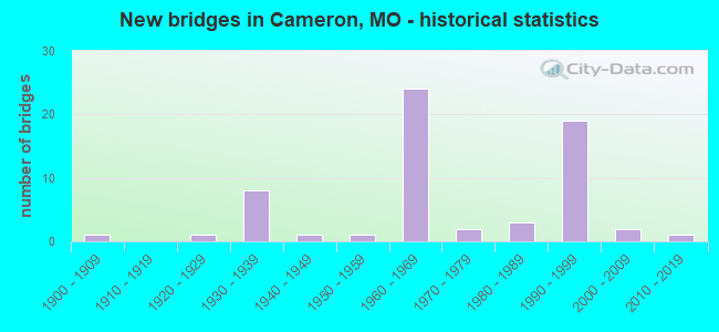
- New bridges - historical statistics
- 11900-1909
- 11920-1929
- 81930-1939
- 11940-1949
- 11950-1959
- 241960-1969
- 21970-1979
- 31980-1989
- 191990-1999
- 22000-2009
- 12010-2019
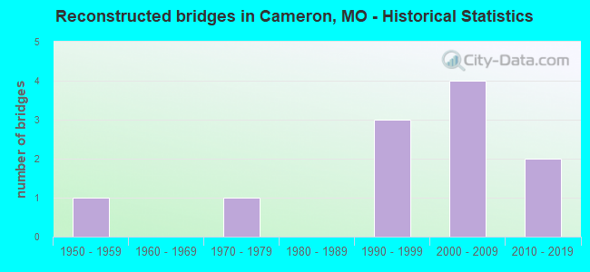
- Reconstructed bridges - Historical Statistics
- 11950-1959
- 01960-1969
- 11970-1979
- 01980-1989
- 31990-1999
- 42000-2009
- 22010-2019
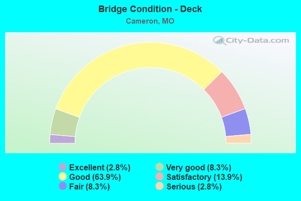
- Bridge Condition - Deck
- 2.8%Excellent
- 8.3%Very good
- 63.9%Good
- 13.9%Satisfactory
- 8.3%Fair
- 2.8%Serious
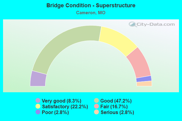
- Bridge Condition - Superstructure
- 8.3%Very good
- 47.2%Good
- 22.2%Satisfactory
- 16.7%Fair
- 2.8%Poor
- 2.8%Serious
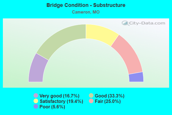
- Bridge Condition - Substructure
- 16.7%Very good
- 33.3%Good
- 19.4%Satisfactory
- 25.0%Fair
- 5.6%Poor
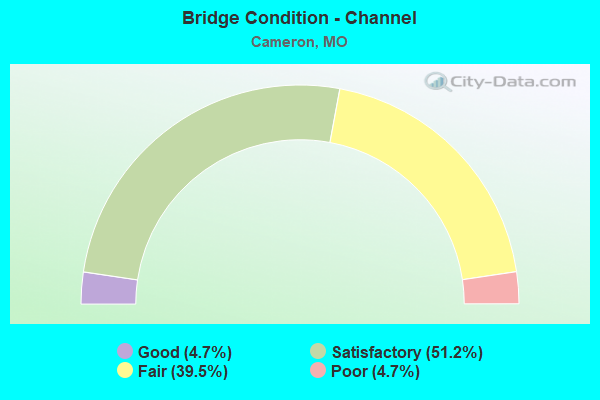
- Bridge Condition - Channel
- 4.7%Good
- 51.2%Satisfactory
- 39.5%Fair
- 4.7%Poor
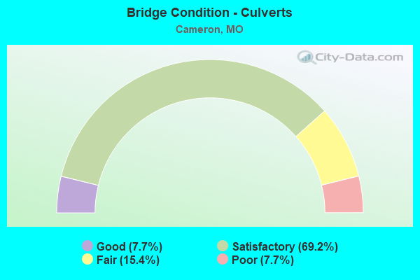
- Bridge Condition - Culverts
- 7.7%Good
- 69.2%Satisfactory
- 15.4%Fair
- 7.7%Poor
Find on map >> Show street view
Structure Number: 8806, Location: S 19 T 27 N R 10 E (Lat: 36.976625, Lng: -90.002556), Route carried "on" structure: State highway M, Year Built: 1933, Status: Posted for load, Structure Length: 2.19m (7.19ft), Average Daily Traffic: 242 (year 2021), Truck Traffic: 12%, Average Future Daily Traffic: 339 (year 2041), Design Load: H 10, Features Intersected: MUD CR
Minimum Vertical Clearance: 30+ m (98+ ft), Kilometerpoint: 4.744, Lanes on structure: 1, Owner: State Highway Agency, Approaching Roadway Width: 6.1m (20.0ft), Skew: 3 degrees, Material/Design: Steel, Design/Construction: Stringer/Multi-beam, Number Of Spans In Main Unit: 3, Length of Maximum Span: 7.0m (23.0ft), Curb-To-Curb Width: 6.1m (20.0ft), Out-to-Out Width: 6.4m (21.0ft)
Condition: Deck: Fair, Superstructure: Fair, Substructure: Fair, Channel: Fair, Operating Rating: 19.8 metric tons, Method Used To Determine Operating Rating: Allowable Stress (AS), Inventory Rating: 9.9 metric tons, Method Used To Determine Inventory Rating: Allowable Stress (AS), Structural Evaluation: High priority of replacement, Deck Geometry: Meets minimum limits, Waterway Adequacy: Somewhat better than minimum adequacy, Approach Roadway Alignment: Equal to present minimum criteria, Bridge Posting: Required (Relationship of Operating Rating to Maximum Legal Load: 30.0 - 39.9% below), Length Of Structure Improvement: 0.30m (0.98ft), Designated Inspection Frequency: Every 12 months, Inspection Date: October 2021, Bridge Improvement Cost: $306,000, Roadway Improvement Cost: $31,000, Total Project Cost: $459,000 ( Estimate for 2022), Deck Structure Type: Concrete Cast-file-Place, Wearing Surface/Protective System: Wearing Surface: Bituminous
Find on map >> Show street view
Structure Number: 8807, Location: S 3 T 26 N R 6 E (Lat: 36.936711, Lng: -90.398294), Route carried "on" structure: State highway W, Year Built: 1932, Year Reconstructed: 1964, Status: Open, Structure Length: 0.96m (3.15ft), Average Daily Traffic: 417 (year 2021), Truck Traffic: 10%, Average Future Daily Traffic: 605 (year 2041), Features Intersected: BR OF ASHER CR
Minimum Vertical Clearance: 30+ m (98+ ft), Kilometerpoint: 5.604, Lanes on structure: 2, Owner: State Highway Agency, Approaching Roadway Width: 7.3m (24.0ft), Skew: 3 degrees, Material/Design: Concrete continuous, Design/Construction: Culvert, Number Of Spans In Main Unit: 2, Length of Maximum Span: 3.6m (11.8ft), Curb-To-Curb Width: 9.1m (29.9ft), Out-to-Out Width: 9.8m (32.2ft)
Condition: Channel: Satisfactory, Culverts: Satisfactory, Operating Rating: 37.8 metric tons, Method Used To Determine Operating Rating: Load Factor (LF), Inventory Rating: 22.5 metric tons, Method Used To Determine Inventory Rating: Load Factor (LF), Structural Evaluation: Equal to present minimum criteria, Deck Geometry: Equal to present minimum criteria, Waterway Adequacy: Equal to present minimum criteria, Approach Roadway Alignment: Equal to present minimum criteria, Designated Inspection Frequency: Every 24 months, Inspection Date: Febuary 2022
Find on map >> Show street view
Structure Number: 8934, Location: S 4 T 26 N R 28 W (Lat: 36.995833, Lng: -93.997472), Route carried "on" structure: State highway 97, Year Built: 1935, Status: Open, Structure Length: 0.67m (2.20ft), Average Daily Traffic: 847 (year 2021), Truck Traffic: 18%, Average Future Daily Traffic: 1,228 (year 2041), Design Load: H 10, Features Intersected: DRY BR
Minimum Vertical Clearance: 30+ m (98+ ft), Kilometerpoint: 100.377, Lanes on structure: 2, Owner: State Highway Agency, Approaching Roadway Width: 7.3m (24.0ft), Skew: 2 degrees, Material/Design: Concrete continuous, Design/Construction: Culvert, Number Of Spans In Main Unit: 2, Length of Maximum Span: 3.0m (9.8ft), Curb-To-Curb Width: 7.9m (25.9ft), Out-to-Out Width: 8.5m (27.9ft)
Condition: Channel: Satisfactory, Culverts: Satisfactory, Operating Rating: 40.5 metric tons, Method Used To Determine Operating Rating: Load Factor (LF), Inventory Rating: 24.3 metric tons, Method Used To Determine Inventory Rating: Load Factor (LF), Structural Evaluation: Equal to present minimum criteria, Deck Geometry: Somewhat better than minimum adequacy, Waterway Adequacy: Equal to present minimum criteria, Approach Roadway Alignment: Equal to present desirable criteria, Designated Inspection Frequency: Every 24 months, Inspection Date: April 2021
Find on map >> Show street view
Structure Number: 9003, Location: S 23 T 35 N R 2 E (Lat: 37.781228, Lng: -90.828058), Route carried "on" structure: State highway C, Year Built: 1934, Status: Open, Structure Length: 0.63m (2.07ft), Average Daily Traffic: 2,002 (year 2021), Truck Traffic: 9%, Average Future Daily Traffic: 2,803 (year 2041), Design Load: H 10, Features Intersected: BAY BR
Minimum Vertical Clearance: 30+ m (98+ ft), Kilometerpoint: 31.318, Lanes on structure: 2, Owner: State Highway Agency, Approaching Roadway Width: 6.7m (22.0ft), Material/Design: Concrete continuous, Design/Construction: Culvert, Number Of Spans In Main Unit: 2, Length of Maximum Span: 3.0m (9.8ft), Curb-To-Curb Width: 8.2m (26.9ft), Out-to-Out Width: 8.8m (28.9ft)
Condition: Channel: Satisfactory, Culverts: Satisfactory, Operating Rating: 37.8 metric tons, Method Used To Determine Operating Rating: Load Factor (LF), Inventory Rating: 22.5 metric tons, Method Used To Determine Inventory Rating: Load Factor (LF), Structural Evaluation: Equal to present minimum criteria, Deck Geometry: High priority of corrective action, Waterway Adequacy: Equal to present desirable criteria, Approach Roadway Alignment: Equal to present desirable criteria, Length Of Structure Improvement: 0.12m (0.39ft), Designated Inspection Frequency: Every 24 months, Inspection Date: September 2020, Bridge Improvement Cost: $170,000, Roadway Improvement Cost: $17,000, Total Project Cost: $255,000 ( Estimate for 2022)
Find on map >> Show street view
Structure Number: 9006, Location: S 14 T 56 N R 30 W (Lat: 39.662056, Lng: -94.234408), Route carried "on" structure: State highway 121, Year Built: 1935, Status: Open, Structure Length: 0.64m (2.10ft), Average Daily Traffic: 715 (year 2021), Truck Traffic: 9%, Average Future Daily Traffic: 930 (year 2041), Design Load: H 10, Features Intersected: CHRISTMAN BR
Minimum Vertical Clearance: 30+ m (98+ ft), Kilometerpoint: 0.109, Lanes on structure: 2, Owner: State Highway Agency, Approaching Roadway Width: 7.3m (24.0ft), Material/Design: Concrete continuous, Design/Construction: Culvert, Number Of Spans In Main Unit: 2, Length of Maximum Span: 3.0m (9.8ft), Curb-To-Curb Width: 9.6m (31.5ft), Out-to-Out Width: 10.2m (33.5ft)
Condition: Channel: Fair, Culverts: Fair, Operating Rating: 42.3 metric tons, Method Used To Determine Operating Rating: Load Factor (LF), Inventory Rating: 25.2 metric tons, Method Used To Determine Inventory Rating: Load Factor (LF), Structural Evaluation: Somewhat better than minimum adequacy, Deck Geometry: Equal to present minimum criteria, Waterway Adequacy: Equal to present desirable criteria, Approach Roadway Alignment: Equal to present minimum criteria, Designated Inspection Frequency: Every 24 months, Inspection Date: December 2021
Find on map >> Show street view
Structure Number: 9172, Location: S 12 T 52 N R 16 W (Lat: 39.312178, Lng: -92.660894), Route carried "on" structure: State highway B, Year Built: 1946, Status: Open, Structure Length: 0.63m (2.07ft), Average Daily Traffic: 994 (year 2021), Truck Traffic: 11%, Average Future Daily Traffic: 1,243 (year 2041), Design Load: H 10, Features Intersected: BAGBY CR
Minimum Vertical Clearance: 30+ m (98+ ft), Kilometerpoint: 2.414, Lanes on structure: 2, Owner: State Highway Agency, Approaching Roadway Width: 7.3m (24.0ft), Material/Design: Concrete continuous, Design/Construction: Culvert, Number Of Spans In Main Unit: 2, Length of Maximum Span: 3.0m (9.8ft), Curb-To-Curb Width: 8.1m (26.6ft), Out-to-Out Width: 8.7m (28.5ft)
Condition: Channel: Satisfactory, Culverts: Satisfactory, Operating Rating: 39.6 metric tons, Method Used To Determine Operating Rating: Load Factor (LF), Inventory Rating: 23.4 metric tons, Method Used To Determine Inventory Rating: Load Factor (LF), Structural Evaluation: Equal to present minimum criteria, Deck Geometry: Somewhat better than minimum adequacy, Waterway Adequacy: Equal to present minimum criteria, Approach Roadway Alignment: Equal to present minimum criteria, Designated Inspection Frequency: Every 24 months, Inspection Date: December 2020
Find on map >> Show street view
Structure Number: 942, Location: S 15 T 56 N R 30 W (Lat: 39.667894, Lng: -94.235672), Route carried "on" structure: US 69, Year Built: 1963, Year Reconstructed: 2019, Status: Open, Structure Length: 9.24m (30.31ft), Average Daily Traffic: 1,541 (year 2021), Truck Traffic: 12%, Average Future Daily Traffic: 2,003 (year 2041), Design Load: HS 20, Features Intersected: IS 35
Minimum Vertical Clearance: 30+ m (98+ ft), Kilometerpoint: 115.094, Lanes on structure: 2, Lanes under structure: 4, Owner: State Highway Agency, Approaching Roadway Width: 9.1m (29.9ft), Skew: 4 degrees, Material/Design: Steel continuous, Design/Construction: Stringer/Multi-beam, Number Of Spans In Main Unit: 4, Length of Maximum Span: 26.2m (86.0ft), Curb-To-Curb Width: 9.1m (29.9ft), Out-to-Out Width: 10.0m (32.8ft)
Condition: Deck: Excellent, Superstructure: Satisfactory, Substructure: Satisfactory, Operating Rating: 36.0 metric tons, Method Used To Determine Operating Rating: Load Factor (LF), Inventory Rating: 21.6 metric tons, Method Used To Determine Inventory Rating: Load Factor (LF), Structural Evaluation: Somewhat better than minimum adequacy, Deck Geometry: Somewhat better than minimum adequacy, Underclear: Meets minimum limits, Approach Roadway Alignment: Equal to present desirable criteria, Designated Inspection Frequency: Every 24 months, Inspection Date: October 2020, Deck Structure Type: Concrete Cast-file-Place, Wearing Surface/Protective System: Wearing Surface: Monolithic Concrete, Deck Protection: Epoxy Coated Reinforcing
Find on map >> Show street view
Structure Number: 2611, Location: S 14 T 57 N R 30 W (Lat: 39.754464, Lng: -94.234317), Route carried "under" structure: US 36, Year Built: 1990, Structure Length: 0. m, Average Daily Traffic: 4,684 (year 2021), Truck Traffic: 25%, Features Intersected: US 36, Facility Carried by Structure: US 69 S
Minimum Vertical Clearance: 4.95m (16.24ft), Kilometerpoint: 54.476, Lanes on structure: 3, Lanes under structure: 2, Material/Design: Steel continuous, Design/Construction: Stringer/Multi-beam, Length of Maximum Span: 36.0m (118.1ft)
Find on map >> Show street view
Structure Number: 2611, Location: S 14 T 57 N R 30 W (Lat: 39.754464, Lng: -94.234317), Route carried "under" structure: US 36, Year Built: 1990, Structure Length: 0. m, Average Daily Traffic: 6,062 (year 2021), Truck Traffic: 18%, Features Intersected: US 36, Facility Carried by Structure: US 69 S
Minimum Vertical Clearance: 4.95m (16.24ft), Kilometerpoint: 255.616, Lanes on structure: 3, Lanes under structure: 2, Material/Design: Steel continuous, Design/Construction: Stringer/Multi-beam, Length of Maximum Span: 36.0m (118.1ft)
Find on map >> Show street view
Structure Number: 752, Location: S 24 T 57 N R 30 W (Lat: 39.742458, Lng: -94.220197), Route carried "under" structure: Interstate 35, Year Built: 1963, Structure Length: 0. m, Average Daily Traffic: 9,767 (year 2021), Truck Traffic: 32%, Features Intersected: IS 35, Facility Carried by Structure: GRAND AVE E
Minimum Vertical Clearance: 5.08m (16.67ft), Kilometerpoint: 97.687, Lanes on structure: 2, Lanes under structure: 2, Material/Design: Concrete continuous, Design/Construction: Slab, Length of Maximum Span: 20.1m (65.9ft)
Find on map >> Show street view
Structure Number: 752, Location: S 24 T 57 N R 30 W (Lat: 39.742458, Lng: -94.220197), Route carried "under" structure: Interstate 35, Year Built: 1963, Structure Length: 0. m, Average Daily Traffic: 8,610 (year 2021), Truck Traffic: 29%, Features Intersected: IS 35, Facility Carried by Structure: GRAND AVE E
Minimum Vertical Clearance: 5.03m (16.50ft), Kilometerpoint: 86.473, Lanes on structure: 2, Lanes under structure: 2, Material/Design: Concrete continuous, Design/Construction: Slab, Length of Maximum Span: 20.1m (65.9ft)
Find on map >> Show street view
Structure Number: 8206, Location: S 30 T 58 N R 29 W (Lat: 39.803325, Lng: -94.199075), Route carried "under" structure: Interstate 35, Year Built: 1964, Structure Length: 0. m, Average Daily Traffic: 8,839 (year 2021), Truck Traffic: 29%, Features Intersected: IS 35, Facility Carried by Structure: RT BB E
Minimum Vertical Clearance: 4.95m (16.24ft), Kilometerpoint: 90.638, Lanes on structure: 2, Lanes under structure: 2, Material/Design: Concrete continuous, Design/Construction: Slab, Length of Maximum Span: 21.0m (68.9ft)
Find on map >> Show street view
Structure Number: 8206, Location: S 30 T 58 N R 29 W (Lat: 39.803325, Lng: -94.199075), Route carried "under" structure: Interstate 35, Year Built: 1964, Structure Length: 0. m, Average Daily Traffic: 8,591 (year 2021), Truck Traffic: 26%, Features Intersected: IS 35, Facility Carried by Structure: RT BB E
Minimum Vertical Clearance: 4.95m (16.24ft), Kilometerpoint: 93.522, Lanes on structure: 2, Lanes under structure: 2, Material/Design: Concrete continuous, Design/Construction: Slab, Length of Maximum Span: 21.0m (68.9ft)
Find on map >> Show street view
Structure Number: 8238, Location: S 24 T 57 N R 40 W (Lat: 39.731597, Lng: -94.220594), Route carried "under" structure: Interstate 35, Year Built: 1963, Structure Length: 0. m, Average Daily Traffic: 12,110 (year 2021), Truck Traffic: 29%, Features Intersected: IS 35, Facility Carried by Structure: RT BB S
Minimum Vertical Clearance: 4.95m (16.24ft), Kilometerpoint: 85.268, Lanes on structure: 2, Lanes under structure: 2, Material/Design: Concrete continuous, Design/Construction: Slab, Length of Maximum Span: 20.1m (65.9ft)
Find on map >> Show street view
Structure Number: 8238, Location: S 24 T 57 N R 40 W (Lat: 39.731597, Lng: -94.220594), Route carried "under" structure: Interstate 35, Year Built: 1963, Structure Length: 0. m, Average Daily Traffic: 9,767 (year 2021), Truck Traffic: 32%, Features Intersected: IS 35, Facility Carried by Structure: RT BB S
Minimum Vertical Clearance: 4.90m (16.08ft), Kilometerpoint: 98.896, Lanes on structure: 2, Lanes under structure: 2, Material/Design: Concrete continuous, Design/Construction: Slab, Length of Maximum Span: 20.1m (65.9ft)
Find on map >> Show street view
Structure Number: 854, Location: S 13 T 57 N R 30 W (Lat: 39.753619, Lng: -94.219919), Route carried "under" structure: Interstate 35, Year Built: 1963, Structure Length: 0. m, Average Daily Traffic: 8,610 (year 2021), Truck Traffic: 29%, Features Intersected: IS 35, Facility Carried by Structure: US 36 E
Minimum Vertical Clearance: 4.95m (16.24ft), Kilometerpoint: 87.711, Lanes on structure: 2, Lanes under structure: 2, Material/Design: Steel continuous, Design/Construction: Stringer/Multi-beam, Length of Maximum Span: 20.1m (65.9ft)
Find on map >> Show street view
Structure Number: 854, Location: S 13 T 57 N R 30 W (Lat: 39.753619, Lng: -94.219919), Route carried "under" structure: Interstate 35, Year Built: 1963, Structure Length: 0. m, Average Daily Traffic: 8,839 (year 2021), Truck Traffic: 29%, Features Intersected: IS 35, Facility Carried by Structure: US 36 E
Minimum Vertical Clearance: 4.98m (16.34ft), Kilometerpoint: 96.448, Lanes on structure: 2, Lanes under structure: 2, Material/Design: Steel continuous, Design/Construction: Stringer/Multi-beam, Length of Maximum Span: 20.1m (65.9ft)
Find on map >> Show street view
Structure Number: 855, Location: S 13 T 57 N R 30 W (Lat: 39.753836, Lng: -94.219864), Route carried "under" structure: Interstate 35, Year Built: 1963, Structure Length: 0. m, Average Daily Traffic: 8,839 (year 2021), Truck Traffic: 29%, Features Intersected: IS 35, Facility Carried by Structure: US 36 W
Minimum Vertical Clearance: 4.95m (16.24ft), Kilometerpoint: 96.424, Lanes on structure: 2, Lanes under structure: 2, Material/Design: Steel continuous, Design/Construction: Stringer/Multi-beam, Length of Maximum Span: 20.1m (65.9ft)
Find on map >> Show street view
Structure Number: 855, Location: S 13 T 57 N R 30 W (Lat: 39.753836, Lng: -94.219864), Route carried "under" structure: Interstate 35, Year Built: 1963, Structure Length: 0. m, Average Daily Traffic: 8,591 (year 2021), Truck Traffic: 26%, Features Intersected: IS 35, Facility Carried by Structure: US 36 W
Minimum Vertical Clearance: 5.08m (16.67ft), Kilometerpoint: 87.735, Lanes on structure: 2, Lanes under structure: 2, Material/Design: Steel continuous, Design/Construction: Stringer/Multi-beam, Length of Maximum Span: 20.1m (65.9ft)
Find on map >> Show street view
Structure Number: 942, Location: S 15 T 56 N R 30 W (Lat: 39.667894, Lng: -94.235672), Route carried "under" structure: Interstate 35, Year Built: 1963, Structure Length: 0. m, Average Daily Traffic: 12,307 (year 2021), Truck Traffic: 37%, Features Intersected: IS 35, Facility Carried by Structure: US 69 S
Minimum Vertical Clearance: 4.98m (16.34ft), Kilometerpoint: 106.074, Lanes on structure: 2, Lanes under structure: 2, Material/Design: Steel continuous, Design/Construction: Stringer/Multi-beam, Length of Maximum Span: 26.2m (86.0ft)
Find on map >> Show street view
Structure Number: 942, Location: S 15 T 56 N R 30 W (Lat: 39.667894, Lng: -94.235672), Route carried "under" structure: Interstate 35, Year Built: 1963, Structure Length: 0. m, Average Daily Traffic: 13,132 (year 2021), Truck Traffic: 29%, Features Intersected: IS 35, Facility Carried by Structure: US 69 S
Minimum Vertical Clearance: 4.98m (16.34ft), Kilometerpoint: 78.060, Lanes on structure: 2, Lanes under structure: 2, Material/Design: Steel continuous, Design/Construction: Stringer/Multi-beam, Length of Maximum Span: 26.2m (86.0ft)