Bridge Statistics for Cape Girardeau, Missouri (MO)
Condition, Traffic, Stress, Structural Evaluation, Project Costs
- National Bridge Inventory (NBI) Statistics
- 126Number of bridges
- 2,103ft / 641mTotal length
- $12,666,000Total costs
- 780,535Total average daily traffic
- 123,867Total average daily truck traffic
- National Bridge Inventory (NBI) Registered Bridges for Cape Girardeau
- No street view available for this location
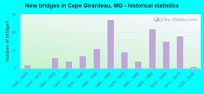
- New bridges - historical statistics
- 21900-1909
- 61920-1929
- 41930-1939
- 71940-1949
- 111950-1959
- 271960-1969
- 91970-1979
- 41980-1989
- 221990-1999
- 152000-2009
- 182010-2019
- 12020-2022
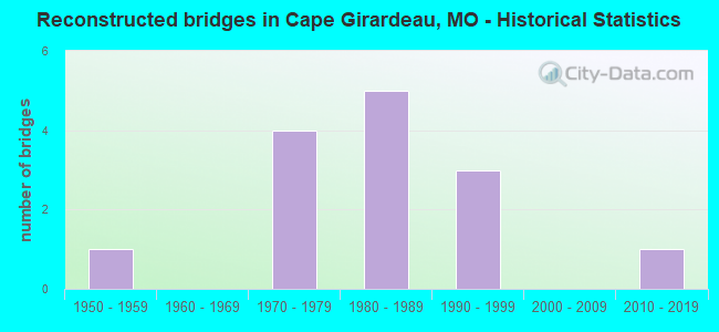
- Reconstructed bridges - Historical Statistics
- 11950-1959
- 01960-1969
- 41970-1979
- 51980-1989
- 31990-1999
- 02000-2009
- 12010-2019
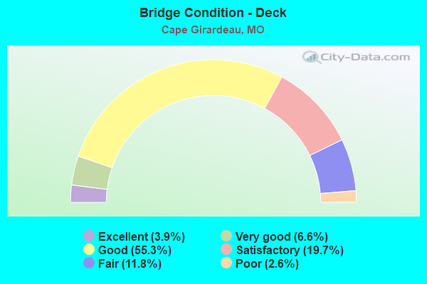
- Bridge Condition - Deck
- 3.9%Excellent
- 6.6%Very good
- 55.3%Good
- 19.7%Satisfactory
- 11.8%Fair
- 2.6%Poor
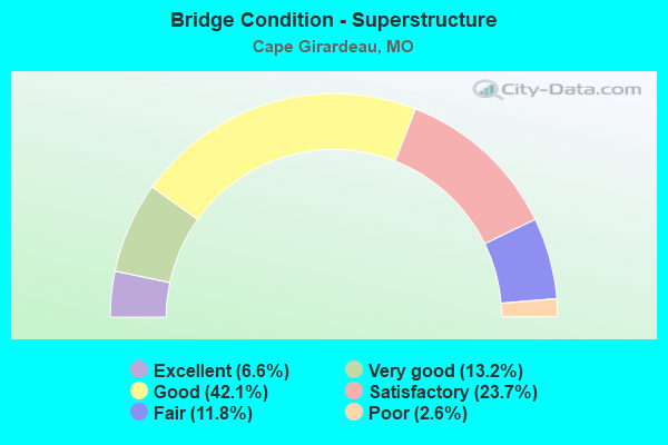
- Bridge Condition - Superstructure
- 6.6%Excellent
- 13.2%Very good
- 42.1%Good
- 23.7%Satisfactory
- 11.8%Fair
- 2.6%Poor
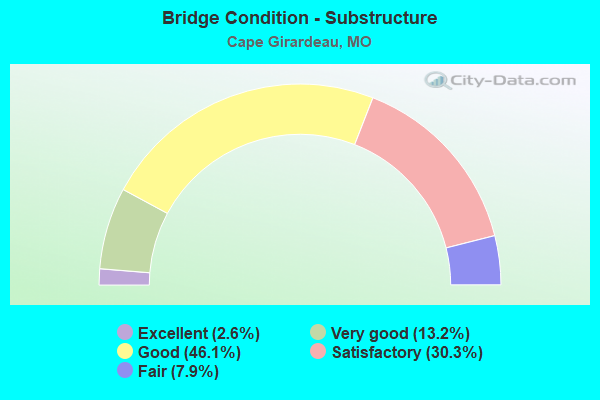
- Bridge Condition - Substructure
- 2.6%Excellent
- 13.2%Very good
- 46.1%Good
- 30.3%Satisfactory
- 7.9%Fair
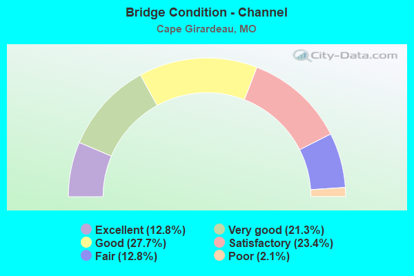
- Bridge Condition - Channel
- 12.8%Excellent
- 21.3%Very good
- 27.7%Good
- 23.4%Satisfactory
- 12.8%Fair
- 2.1%Poor
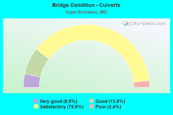
- Bridge Condition - Culverts
- 6.9%Very good
- 13.8%Good
- 75.9%Satisfactory
- 3.4%Poor
Find on map >> Show street view
Structure Number: 402, Location: S 2199 T 30 N R 13 E (Lat: 37.306119, Lng: -89.551989), Route carried "on" structure: US 61, Year Built: 1990, Status: Open, Structure Length: 1.53m (5.02ft), Average Daily Traffic: 28,482 (year 2021), Truck Traffic: 6%, Average Future Daily Traffic: 46,995 (year 2041), Design Load: HS 20, Features Intersected: WALKER CR
Minimum Vertical Clearance: 30+ m (98+ ft), Kilometerpoint: 465.368, Lanes on structure: 4, Base Highway Network: Yes, Owner: State Highway Agency, Approaching Roadway Width: 22.3m (73.2ft), Material/Design: Concrete continuous, Design/Construction: Culvert, Number Of Spans In Main Unit: 4, Length of Maximum Span: 3.7m (12.1ft)
Condition: Channel: Very good, Culverts: Satisfactory, Operating Rating: 48.6 metric tons, Method Used To Determine Operating Rating: Load Factor (LF), Inventory Rating: 28.8 metric tons, Method Used To Determine Inventory Rating: Load Factor (LF), Structural Evaluation: Equal to present minimum criteria, Waterway Adequacy: Equal to present desirable criteria, Approach Roadway Alignment: Equal to present desirable criteria, Designated Inspection Frequency: Every 24 months, Inspection Date: Febuary 2022
Find on map >> Show street view
Structure Number: 4089, Location: S 222 T 30 N R 14 E (Lat: 37.295136, Lng: -89.518278), Route carried "on" structure: State highway 74, Year Built: 1997, Status: Open, Structure Length: 120.58m (395.60ft), Average Daily Traffic: 10,578 (year 2021), Truck Traffic: 12%, Average Future Daily Traffic: 20,627 (year 2041), Design Load: HS 20+Mod, Features Intersected: MISSISSIPPI RVR, CST AQU
Minimum Vertical Clearance: 30+ m (98+ ft), Kilometerpoint: 16.654, Lanes on structure: 4, Lanes under structure: 2, Base Highway Network: Yes, Owner: State Highway Agency, Approaching Roadway Width: 24.4m (80.1ft), Skew: 30 degrees, Navigation Control: Yes ( Vertical Clearance: 18.3m (60.0ft), Horizontal Clearance: 248.4m (815.0ft)), Material/Design: Steel continuous, Design/Construction: Stayed Girder, Number Of Spans In Main Unit: 3, Number Of Approach Spans: 11, Length of Maximum Span: 350.5m (1,149.9ft), Curb-To-Curb Width: 24.4m (80.1ft), Out-to-Out Width: 26.3m (86.3ft)
Condition: Deck: Satisfactory, Superstructure: Very good, Substructure: Satisfactory, Channel: Fair, Operating Rating: 63.9 metric tons, Method Used To Determine Operating Rating: Load Factor (LF), Inventory Rating: 42.3 metric tons, Method Used To Determine Inventory Rating: Load Factor (LF), Structural Evaluation: Equal to present minimum criteria, Deck Geometry: Superior to present desirable criteria, Underclear: Superior to present desirable criteria, Waterway Adequacy: Equal to present desirable criteria, Approach Roadway Alignment: Equal to present desirable criteria, Designated Inspection Frequency: Every 24 months, Critical Feature Inspection Frequency: Every 24 months, Underwater Inspection Frequency: Every 60 months, Inspection Date: May 2020, Critical Feature Inspection Date: May 2020, Underwater Inspection Date: August 2021, Deck Structure Type: Concrete Precast Panels, Wearing Surface/Protective System: Wearing Surface: Other, Deck Protection: Epoxy Coated Reinforcing
Find on map >> Show street view
Structure Number: 4091, Location: S 7 T 30 N R 14 E (Lat: 37.290853, Lng: -89.548633), Route carried "on" structure: State highway 74, Year Built: 1994, Status: Open, Structure Length: 26.33m (86.38ft), Average Daily Traffic: 5,431 (year 2021), Truck Traffic: 12%, Average Future Daily Traffic: 10,590 (year 2041), Design Load: HS 20+Mod, Features Intersected: CAPE LA CROIX CR
Minimum Vertical Clearance: 30+ m (98+ ft), Kilometerpoint: 13.845, Lanes on structure: 2, Base Highway Network: Yes, Owner: State Highway Agency, Approaching Roadway Width: 12.8m (42.0ft), Skew: 1 degrees, Material/Design: Prestressed concrete continuous, Design/Construction: Stringer/Multi-beam, Number Of Spans In Main Unit: 12, Length of Maximum Span: 26.2m (86.0ft), Curb or Sidewalk Widths: Left: 0.2m (0.7ft), Right: 0.2m (0.7ft), Curb-To-Curb Width: 12.2m (40.0ft), Out-to-Out Width: 13.0m (42.7ft)
Condition: Deck: Good, Superstructure: Satisfactory, Substructure: Satisfactory, Channel: Satisfactory, Operating Rating: 67.5 metric tons, Method Used To Determine Operating Rating: Load Factor (LF), Inventory Rating: 40.5 metric tons, Method Used To Determine Inventory Rating: Load Factor (LF), Structural Evaluation: Equal to present minimum criteria, Deck Geometry: Better than present minimum criteria, Waterway Adequacy: Equal to present desirable criteria, Approach Roadway Alignment: Equal to present desirable criteria, Designated Inspection Frequency: Every 24 months, Inspection Date: November 2021, Deck Structure Type: Concrete Cast-file-Place, Wearing Surface/Protective System: Wearing Surface: Monolithic Concrete, Deck Protection: Epoxy Coated Reinforcing
Find on map >> Show street view
Structure Number: 4126, Location: S 7 T 30 N R 14 E (Lat: 37.291017, Lng: -89.548594), Route carried "on" structure: State highway 74, Year Built: 1994, Status: Open, Structure Length: 26.33m (86.38ft), Average Daily Traffic: 5,686 (year 2021), Truck Traffic: 11%, Average Future Daily Traffic: 11,088 (year 2041), Design Load: HS 20+Mod, Features Intersected: CAPE LA CROIX CR
Minimum Vertical Clearance: 30+ m (98+ ft), Kilometerpoint: 2.887, Lanes on structure: 2, Base Highway Network: Yes, Owner: State Highway Agency, Approaching Roadway Width: 12.8m (42.0ft), Skew: 1 degrees, Material/Design: Prestressed concrete continuous, Design/Construction: Stringer/Multi-beam, Number Of Spans In Main Unit: 3, Number Of Approach Spans: 9, Length of Maximum Span: 26.2m (86.0ft), Curb or Sidewalk Widths: Left: 0.2m (0.7ft), Right: 0.2m (0.7ft), Curb-To-Curb Width: 12.2m (40.0ft), Out-to-Out Width: 13.0m (42.7ft)
Condition: Deck: Good, Superstructure: Satisfactory, Substructure: Satisfactory, Channel: Satisfactory, Operating Rating: 67.5 metric tons, Method Used To Determine Operating Rating: Load Factor (LF), Inventory Rating: 40.5 metric tons, Method Used To Determine Inventory Rating: Load Factor (LF), Structural Evaluation: Equal to present minimum criteria, Deck Geometry: Better than present minimum criteria, Waterway Adequacy: Equal to present desirable criteria, Approach Roadway Alignment: Equal to present desirable criteria, Designated Inspection Frequency: Every 24 months, Inspection Date: November 2021, Deck Structure Type: Concrete Cast-file-Place, Wearing Surface/Protective System: Wearing Surface: Monolithic Concrete, Deck Protection: Epoxy Coated Reinforcing
Find on map >> Show street view
Structure Number: 4188, Location: S 174 T 30 N R 13 E (Lat: 37.283181, Lng: -89.573850), Route carried "on" structure: ServiceState highway 55, Year Built: 1993, Status: Open, Structure Length: 1.01m (3.31ft), Average Daily Traffic: 206 (year 2021), Truck Traffic: 5%, Average Future Daily Traffic: 319 (year 2041), Design Load: HS 20, Features Intersected: RAMSEY BR
Minimum Vertical Clearance: 30+ m (98+ ft), Kilometerpoint: 0.703, Lanes on structure: 2, Owner: State Highway Agency, Approaching Roadway Width: 8.5m (27.9ft), Skew: 23 degrees, Material/Design: Concrete continuous, Design/Construction: Culvert, Number Of Spans In Main Unit: 2, Length of Maximum Span: 4.0m (13.1ft)
Condition: Channel: Very good, Culverts: Satisfactory, Operating Rating: 87.3 metric tons, Method Used To Determine Operating Rating: Field evaluation and documented engineering judgment, Inventory Rating: 52.2 metric tons, Method Used To Determine Inventory Rating: Field evaluation and documented engineering judgment, Structural Evaluation: Equal to present minimum criteria, Waterway Adequacy: Superior to present desirable criteria, Approach Roadway Alignment: Equal to present desirable criteria, Designated Inspection Frequency: Every 24 months, Inspection Date: Febuary 2022
Find on map >> Show street view
Structure Number: 4189, Location: S 679 T 30 N R 13 E (Lat: 37.284589, Lng: -89.574850), Route carried "on" structure: ServiceState highway 55, Year Built: 1993, Status: Open, Structure Length: 0.83m (2.72ft), Average Daily Traffic: 206 (year 2021), Truck Traffic: 5%, Average Future Daily Traffic: 319 (year 2041), Design Load: HS 20, Features Intersected: RAMSEY BR
Minimum Vertical Clearance: 30+ m (98+ ft), Kilometerpoint: 0.439, Lanes on structure: 4, Owner: State Highway Agency, Approaching Roadway Width: 24.4m (80.1ft), Skew: 20 degrees, Material/Design: Concrete continuous, Design/Construction: Culvert, Number Of Spans In Main Unit: 2, Length of Maximum Span: 4.0m (13.1ft)
Condition: Channel: Very good, Culverts: Satisfactory, Operating Rating: 87.3 metric tons, Method Used To Determine Operating Rating: Field evaluation and documented engineering judgment, Inventory Rating: 52.2 metric tons, Method Used To Determine Inventory Rating: Field evaluation and documented engineering judgment, Structural Evaluation: Equal to present minimum criteria, Waterway Adequacy: Superior to present desirable criteria, Approach Roadway Alignment: Equal to present desirable criteria, Designated Inspection Frequency: Every 24 months, Inspection Date: Febuary 2022
Find on map >> Show street view
Structure Number: 459, Location: S 14 T 30 N R 13 E (Lat: 37.266161, Lng: -89.567417), Route carried "on" structure: US 61, Year Built: 1961, Status: Open, Structure Length: 12.25m (40.19ft), Average Daily Traffic: 6,950 (year 2021), Truck Traffic: 17%, Average Future Daily Traffic: 13,553 (year 2041), Design Load: H 20, Features Intersected: IS 55
Minimum Vertical Clearance: 30+ m (98+ ft), Kilometerpoint: 470.097, Lanes on structure: 2, Lanes under structure: 4, Base Highway Network: Yes, Owner: State Highway Agency, Approaching Roadway Width: 9.8m (32.2ft), Material/Design: Concrete continuous, Design/Construction: Box Beam or Girders - Single/Spread, Number Of Spans In Main Unit: 4, Length of Maximum Span: 38.4m (126.0ft), Curb-To-Curb Width: 8.5m (27.9ft), Out-to-Out Width: 9.6m (31.5ft)
Condition: Deck: Poor, Superstructure: Poor, Substructure: Satisfactory, Operating Rating: 72.0 metric tons, Method Used To Determine Operating Rating: Load Factor (LF), Inventory Rating: 43.2 metric tons, Method Used To Determine Inventory Rating: Load Factor (LF), Structural Evaluation: Meets minimum limits, Deck Geometry: High priority of corrective action, Underclear: Somewhat better than minimum adequacy, Approach Roadway Alignment: Better than present minimum criteria, Length Of Structure Improvement: 1.31m (4.30ft), Designated Inspection Frequency: Every 12 months, Inspection Date: November 2021, Bridge Improvement Cost: $1,574,000, Roadway Improvement Cost: $157,000, Total Project Cost: $2,360,000 ( Estimate for 2022), Deck Structure Type: Concrete Cast-file-Place, Wearing Surface/Protective System: Wearing Surface: Bituminous
Find on map >> Show street view
Structure Number: 5038, Location: S 3314 T 31 N R 13 E (Lat: 37.331661, Lng: -89.571292), Route carried "on" structure: US 61, Year Built: 1927, Year Reconstructed: 1977, Status: Open, Structure Length: 3.87m (12.70ft), Average Daily Traffic: 19,525 (year 2021), Truck Traffic: 6%, Average Future Daily Traffic: 32,216 (year 2041), Design Load: HS 20, Features Intersected: CAPE LA CROIX CR
Minimum Vertical Clearance: 30+ m (98+ ft), Kilometerpoint: 461.873, Lanes on structure: 4, Base Highway Network: Yes, Owner: State Highway Agency, Approaching Roadway Width: 20.7m (67.9ft), Skew: 20 degrees, Material/Design: Prestressed concrete, Design/Construction: Box Beam or Girders - Multiple, Number Of Spans In Main Unit: 1, Length of Maximum Span: 22.2m (72.8ft), Curb-To-Curb Width: 21.9m (71.9ft), Out-to-Out Width: 23.0m (75.5ft)
Condition: Deck: Satisfactory, Superstructure: Satisfactory, Substructure: Satisfactory, Channel: Satisfactory, Operating Rating: 55.8 metric tons, Method Used To Determine Operating Rating: Load Factor (LF), Inventory Rating: 33.3 metric tons, Method Used To Determine Inventory Rating: Load Factor (LF), Structural Evaluation: Equal to present minimum criteria, Deck Geometry: Superior to present desirable criteria, Waterway Adequacy: Equal to present desirable criteria, Approach Roadway Alignment: Equal to present desirable criteria, Designated Inspection Frequency: Every 24 months, Inspection Date: November 2021, Deck Structure Type: Concrete Cast-file-Place, Wearing Surface/Protective System: Wearing Surface: Bituminous, Membrane: Built-up
Find on map >> Show street view
Structure Number: 5039, Location: S 2199 T 30 N R 13 E (Lat: 37.300583, Lng: -89.553114), Route carried "on" structure: US 61, Year Built: 1927, Year Reconstructed: 1984, Status: Open, Structure Length: 3.90m (12.80ft), Average Daily Traffic: 17,001 (year 2021), Truck Traffic: 6%, Average Future Daily Traffic: 28,052 (year 2041), Design Load: H 15, Features Intersected: CAPE LA CROIX CR
Minimum Vertical Clearance: 30+ m (98+ ft), Kilometerpoint: 466.011, Lanes on structure: 4, Base Highway Network: Yes, Owner: State Highway Agency, Approaching Roadway Width: 15.2m (49.9ft), Material/Design: Concrete, Design/Construction: Tee Beam, Number Of Spans In Main Unit: 3, Length of Maximum Span: 13.0m (42.7ft), Curb-To-Curb Width: 15.2m (49.9ft), Out-to-Out Width: 16.2m (53.1ft)
Condition: Deck: Fair, Superstructure: Fair, Substructure: Satisfactory, Channel: Excellent, Operating Rating: 36.0 metric tons, Method Used To Determine Operating Rating: Load Factor (LF), Inventory Rating: 21.6 metric tons, Method Used To Determine Inventory Rating: Load Factor (LF), Structural Evaluation: Somewhat better than minimum adequacy, Deck Geometry: High priority of corrective action, Waterway Adequacy: Equal to present desirable criteria, Approach Roadway Alignment: Equal to present desirable criteria, Length Of Structure Improvement: 0.48m (1.57ft), Designated Inspection Frequency: Every 24 months, Inspection Date: November 2021, Bridge Improvement Cost: $998,000, Roadway Improvement Cost: $100,000, Total Project Cost: $1,498,000 ( Estimate for 2022), Deck Structure Type: Concrete Cast-file-Place, Wearing Surface/Protective System: Wearing Surface: Latex Concrete, Membrane: Built-up, Deck Protection: Epoxy Coated Reinforcing
Find on map >> Show street view
Structure Number: 504, Location: S 24 T 30 N R 13 E (Lat: 37.259917, Lng: -89.564875), Route carried "on" structure: City street , Year Built: 1928, Status: Posted for load, Structure Length: 5.39m (17.68ft), Average Daily Traffic: 354 (year 2021), Truck Traffic: 5%, Average Future Daily Traffic: 549 (year 2041), Design Load: H 15, Features Intersected: LITTLE RAMSEY CR, Facility Carried by Structure: KINGSHIGHWAY S
Minimum Vertical Clearance: 30+ m (98+ ft), Kilometerpoint: 12.381, Lanes on structure: 2, Owner: State Highway Agency, Approaching Roadway Width: 5.5m (18.0ft), Material/Design: Steel, Design/Construction: Truss - Thru, Number Of Spans In Main Unit: 1, Number Of Approach Spans: 2, Length of Maximum Span: 24.5m (80.4ft), Curb-To-Curb Width: 6.1m (20.0ft), Out-to-Out Width: 6.4m (21.0ft)
Condition: Deck: Fair, Superstructure: Fair, Substructure: Satisfactory, Channel: Fair, Operating Rating: 22.5 metric tons, Method Used To Determine Operating Rating: Allowable Stress (AS), Inventory Rating: 12.6 metric tons, Method Used To Determine Inventory Rating: Allowable Stress (AS), Structural Evaluation: Meets minimum limits, Deck Geometry: Meets minimum limits, Waterway Adequacy: Better than present minimum criteria, Approach Roadway Alignment: Equal to present minimum criteria, Bridge Posting: Required (Relationship of Operating Rating to Maximum Legal Load: 20.0 - 29.9% below), Designated Inspection Frequency: Every 24 months, Critical Feature Inspection Frequency: Every 24 months, Inspection Date: November 2021, Critical Feature Inspection Date: November 2021, Deck Structure Type: Concrete Cast-file-Place, Wearing Surface/Protective System: Wearing Surface: Monolithic Concrete
Find on map >> Show street view
Structure Number: 5041, Location: S 24 T 30 N R 13 E (Lat: 37.258964, Lng: -89.564819), Route carried "on" structure: City street , Year Built: 1928, Status: Open, Structure Length: 4.51m (14.80ft), Average Daily Traffic: 354 (year 2021), Truck Traffic: 5%, Average Future Daily Traffic: 549 (year 2041), Design Load: H 15, Features Intersected: BNSF RR, Facility Carried by Structure: KINGSHIGHWAY S
Minimum Vertical Clearance: 30+ m (98+ ft), Kilometerpoint: 12.490, Lanes on structure: 2, Owner: State Highway Agency, Approaching Roadway Width: 5.5m (18.0ft), Skew: 2 degrees, Material/Design: Concrete, Design/Construction: Tee Beam, Number Of Spans In Main Unit: 3, Length of Maximum Span: 16.0m (52.5ft), Curb-To-Curb Width: 6.1m (20.0ft), Out-to-Out Width: 7.0m (23.0ft)
Condition: Deck: Good, Superstructure: Satisfactory, Substructure: Satisfactory, Operating Rating: 40.5 metric tons, Method Used To Determine Operating Rating: Load Factor (LF), Inventory Rating: 24.3 metric tons, Method Used To Determine Inventory Rating: Load Factor (LF), Structural Evaluation: Equal to present minimum criteria, Deck Geometry: Meets minimum limits, Underclear: Somewhat better than minimum adequacy, Approach Roadway Alignment: Equal to present minimum criteria, Designated Inspection Frequency: Every 24 months, Inspection Date: November 2021, Deck Structure Type: Concrete Cast-file-Place, Wearing Surface/Protective System: Wearing Surface: Monolithic Concrete
Find on map >> Show street view
Structure Number: 5306, Location: S 2190 T 30 N R 13 E (Lat: 37.259350, Lng: -89.617861), Route carried "on" structure: State highway 74, Year Built: 1930, Status: Open, Structure Length: 0.64m (2.10ft), Average Daily Traffic: 3,541 (year 2021), Truck Traffic: 17%, Average Future Daily Traffic: 5,843 (year 2041), Design Load: H 15, Features Intersected: LITTLE RAMSEY CR
Minimum Vertical Clearance: 30+ m (98+ ft), Kilometerpoint: 3.742, Lanes on structure: 2, Base Highway Network: Yes, Owner: State Highway Agency, Approaching Roadway Width: 9.8m (32.2ft), Material/Design: Concrete continuous, Design/Construction: Culvert, Number Of Spans In Main Unit: 2, Length of Maximum Span: 3.0m (9.8ft), Curb-To-Curb Width: 10.4m (34.1ft), Out-to-Out Width: 11.0m (36.1ft)
Condition: Channel: Satisfactory, Culverts: Satisfactory, Operating Rating: 53.1 metric tons, Method Used To Determine Operating Rating: Load Factor (LF), Inventory Rating: 31.5 metric tons, Method Used To Determine Inventory Rating: Load Factor (LF), Structural Evaluation: Equal to present minimum criteria, Deck Geometry: Somewhat better than minimum adequacy, Waterway Adequacy: Equal to present minimum criteria, Approach Roadway Alignment: Equal to present minimum criteria, Designated Inspection Frequency: Every 24 months, Inspection Date: Febuary 2022
Find on map >> Show street view
Structure Number: 5623, Location: S 2194 T 30 N R 13 E (Lat: 37.258072, Lng: -89.599156), Route carried "on" structure: State highway 74, Year Built: 1930, Status: Open, Structure Length: 2.99m (9.81ft), Average Daily Traffic: 3,391 (year 2021), Truck Traffic: 17%, Average Future Daily Traffic: 5,595 (year 2041), Design Load: H 15, Features Intersected: JOBS CR
Minimum Vertical Clearance: 30+ m (98+ ft), Kilometerpoint: 5.395, Lanes on structure: 2, Base Highway Network: Yes, Owner: State Highway Agency, Approaching Roadway Width: 6.1m (20.0ft), Material/Design: Concrete, Design/Construction: Tee Beam, Number Of Spans In Main Unit: 3, Length of Maximum Span: 9.9m (32.5ft), Curb-To-Curb Width: 6.9m (22.6ft), Out-to-Out Width: 7.0m (23.0ft)
Condition: Deck: Satisfactory, Superstructure: Satisfactory, Substructure: Good, Channel: Fair, Operating Rating: 52.2 metric tons, Method Used To Determine Operating Rating: Load Factor (LF), Inventory Rating: 31.5 metric tons, Method Used To Determine Inventory Rating: Load Factor (LF), Structural Evaluation: Equal to present minimum criteria, Deck Geometry: High priority of replacement, Waterway Adequacy: Equal to present desirable criteria, Approach Roadway Alignment: Equal to present desirable criteria, Length Of Structure Improvement: 0.39m (1.28ft), Designated Inspection Frequency: Every 24 months, Inspection Date: November 2021, Bridge Improvement Cost: $334,000, Roadway Improvement Cost: $33,000, Total Project Cost: $501,000 ( Estimate for 2022), Deck Structure Type: Concrete Cast-file-Place, Wearing Surface/Protective System: Wearing Surface: Bituminous, Membrane: Built-up
Find on map >> Show street view
Structure Number: 6171, Location: S 2919 T 30 N R 13 E (Lat: 37.267336, Lng: -89.564881), Route carried "on" structure: US 61, Year Built: 1949, Year Reconstructed: 1988, Status: Open, Structure Length: 5.03m (16.50ft), Average Daily Traffic: 6,210 (year 2021), Truck Traffic: 12%, Average Future Daily Traffic: 12,110 (year 2041), Design Load: HS 20, Features Intersected: RAMSEY CR
Minimum Vertical Clearance: 30+ m (98+ ft), Kilometerpoint: 164.258, Lanes on structure: 2, Base Highway Network: Yes, Owner: State Highway Agency, Approaching Roadway Width: 7.3m (24.0ft), Skew: 3 degrees, Material/Design: Steel continuous, Design/Construction: Stringer/Multi-beam, Number Of Spans In Main Unit: 3, Length of Maximum Span: 18.3m (60.0ft), Curb or Sidewalk Widths: Left: 0.2m (0.7ft), Right: 0.2m (0.7ft), Curb-To-Curb Width: 8.8m (28.9ft), Out-to-Out Width: 9.7m (31.8ft)
Condition: Deck: Good, Superstructure: Good, Substructure: Good, Channel: Satisfactory, Operating Rating: 42.3 metric tons, Method Used To Determine Operating Rating: Load Factor (LF), Inventory Rating: 25.2 metric tons, Method Used To Determine Inventory Rating: Load Factor (LF), Structural Evaluation: Equal to present minimum criteria, Deck Geometry: High priority of replacement, Waterway Adequacy: Equal to present desirable criteria, Approach Roadway Alignment: Equal to present desirable criteria, Length Of Structure Improvement: 0.60m (1.97ft), Designated Inspection Frequency: Every 24 months, Inspection Date: November 2021, Bridge Improvement Cost: $490,000, Roadway Improvement Cost: $49,000, Total Project Cost: $735,000 ( Estimate for 2022), Deck Structure Type: Concrete Cast-file-Place, Wearing Surface/Protective System: Wearing Surface: Low Slump Concrete, Membrane: Built-up, Deck Protection: Internally Sealed
Find on map >> Show street view
Structure Number: 6172, Location: S 2919 T 30 N R 13 E (Lat: 37.258206, Lng: -89.567467), Route carried "on" structure: Interstate 55, Year Built: 1949, Year Reconstructed: 1989, Status: Open, Structure Length: 5.00m (16.40ft), Average Daily Traffic: 19,503 (year 2021), Truck Traffic: 17%, Average Future Daily Traffic: 38,031 (year 2041), Design Load: HS 20, Features Intersected: BNSF RR
Minimum Vertical Clearance: 30+ m (98+ ft), Kilometerpoint: 187.600, Lanes on structure: 2, Base Highway Network: Yes, Owner: State Highway Agency, Approaching Roadway Width: 11.6m (38.1ft), Skew: 2 degrees, Material/Design: Steel continuous, Design/Construction: Stringer/Multi-beam, Number Of Spans In Main Unit: 3, Length of Maximum Span: 17.2m (56.4ft), Curb or Sidewalk Widths: Left: 0.2m (0.7ft), Right: 0.2m (0.7ft), Curb-To-Curb Width: 11.2m (36.7ft), Out-to-Out Width: 12.0m (39.4ft)
Condition: Deck: Good, Superstructure: Very good, Substructure: Satisfactory, Operating Rating: 63.9 metric tons, Method Used To Determine Operating Rating: Load Factor (LF), Inventory Rating: 37.8 metric tons, Method Used To Determine Inventory Rating: Load Factor (LF), Structural Evaluation: Equal to present minimum criteria, Deck Geometry: Somewhat better than minimum adequacy, Underclear: Equal to present minimum criteria, Approach Roadway Alignment: Equal to present desirable criteria, Designated Inspection Frequency: Every 24 months, Inspection Date: November 2021, Deck Structure Type: Concrete Cast-file-Place, Wearing Surface/Protective System: Wearing Surface: Monolithic Concrete, Deck Protection: Internally Sealed
Find on map >> Show street view
Structure Number: 6173, Location: S 23 T 30 N R 13 E (Lat: 37.260347, Lng: -89.567503), Route carried "on" structure: Interstate 55, Year Built: 1949, Year Reconstructed: 1989, Status: Open, Structure Length: 4.05m (13.29ft), Average Daily Traffic: 16,295 (year 2021), Truck Traffic: 26%, Average Future Daily Traffic: 31,775 (year 2041), Design Load: HS 20, Features Intersected: MO 74
Minimum Vertical Clearance: 30+ m (98+ ft), Kilometerpoint: 187.363, Lanes on structure: 2, Lanes under structure: 2, Base Highway Network: Yes, Owner: State Highway Agency, Approaching Roadway Width: 14.0m (45.9ft), Material/Design: Steel, Design/Construction: Stringer/Multi-beam, Number Of Spans In Main Unit: 3, Length of Maximum Span: 15.3m (50.2ft), Curb or Sidewalk Widths: Left: 0.2m (0.7ft), Right: 0.2m (0.7ft), Curb-To-Curb Width: 13.7m (44.9ft), Out-to-Out Width: 14.5m (47.6ft)
Condition: Deck: Satisfactory, Superstructure: Satisfactory, Substructure: Satisfactory, Operating Rating: 83.7 metric tons, Method Used To Determine Operating Rating: Load Factor (LF), Inventory Rating: 50.4 metric tons, Method Used To Determine Inventory Rating: Load Factor (LF), Structural Evaluation: Equal to present minimum criteria, Deck Geometry: Superior to present desirable criteria, Underclear: Meets minimum limits, Approach Roadway Alignment: Equal to present desirable criteria, Designated Inspection Frequency: Every 24 months, Inspection Date: November 2021, Deck Structure Type: Concrete Cast-file-Place, Wearing Surface/Protective System: Wearing Surface: Monolithic Concrete, Deck Protection: Internally Sealed
Find on map >> Show street view
Structure Number: 6174, Location: S 25 T 30 N R 13 E (Lat: 37.232944, Lng: -89.565300), Route carried "on" structure: Interstate 55, Year Built: 1950, Year Reconstructed: 1988, Status: Open, Structure Length: 2.10m (6.89ft), Average Daily Traffic: 15,785 (year 2021), Truck Traffic: 21%, Average Future Daily Traffic: 29,992 (year 2041), Design Load: HS 20, Features Intersected: DTCH NO 2
Minimum Vertical Clearance: 30+ m (98+ ft), Kilometerpoint: 190.452, Lanes on structure: 2, Base Highway Network: Yes, Owner: State Highway Agency, Approaching Roadway Width: 11.6m (38.1ft), Skew: 3 degrees, Material/Design: Concrete continuous, Design/Construction: Slab, Number Of Spans In Main Unit: 3, Length of Maximum Span: 7.3m (24.0ft), Curb or Sidewalk Widths: Left: 0.2m (0.7ft), Right: 0.2m (0.7ft), Curb-To-Curb Width: 9.7m (31.8ft), Out-to-Out Width: 10.5m (34.4ft)
Condition: Deck: Satisfactory, Superstructure: Satisfactory, Substructure: Good, Channel: Satisfactory, Operating Rating: 38.7 metric tons, Method Used To Determine Operating Rating: Load Factor (LF), Inventory Rating: 23.4 metric tons, Method Used To Determine Inventory Rating: Load Factor (LF), Structural Evaluation: Somewhat better than minimum adequacy, Deck Geometry: High priority of replacement, Waterway Adequacy: Equal to present desirable criteria, Approach Roadway Alignment: Equal to present desirable criteria, Length Of Structure Improvement: 0.29m (0.95ft), Designated Inspection Frequency: Every 24 months, Inspection Date: Febuary 2021, Bridge Improvement Cost: $236,000, Roadway Improvement Cost: $24,000, Total Project Cost: $355,000 ( Estimate for 2022), Deck Structure Type: Concrete Cast-file-Place, Wearing Surface/Protective System: Wearing Surface: Low Slump Concrete, Membrane: Built-up, Deck Protection: Internally Sealed
Find on map >> Show street view
Structure Number: 6188, Location: S 26 T 30 N R 13 E (Lat: 37.246225, Lng: -89.567217), Route carried "on" structure: Interstate 55, Year Built: 1949, Year Reconstructed: 1989, Status: Open, Structure Length: 44.84m (147.11ft), Average Daily Traffic: 19,503 (year 2021), Truck Traffic: 17%, Average Future Daily Traffic: 38,031 (year 2041), Design Load: HS 20, Features Intersected: DIVERSION CHANNEL
Minimum Vertical Clearance: 30+ m (98+ ft), Kilometerpoint: 188.738, Lanes on structure: 2, Base Highway Network: Yes, Owner: State Highway Agency, Approaching Roadway Width: 11.6m (38.1ft), Material/Design: Steel continuous, Design/Construction: Stringer/Multi-beam, Number Of Spans In Main Unit: 3, Number Of Approach Spans: 30, Length of Maximum Span: 45.7m (149.9ft), Curb or Sidewalk Widths: Left: 0.2m (0.7ft), Right: 0.2m (0.7ft), Curb-To-Curb Width: 11.2m (36.7ft), Out-to-Out Width: 12.0m (39.4ft)
Condition: Deck: Good, Superstructure: Satisfactory, Substructure: Satisfactory, Channel: Fair, Operating Rating: 46.8 metric tons, Method Used To Determine Operating Rating: Load Factor (LF), Inventory Rating: 27.9 metric tons, Method Used To Determine Inventory Rating: Load Factor (LF), Structural Evaluation: Equal to present minimum criteria, Deck Geometry: Somewhat better than minimum adequacy, Waterway Adequacy: Equal to present desirable criteria, Approach Roadway Alignment: Equal to present desirable criteria, Designated Inspection Frequency: Every 24 months, Underwater Inspection Frequency: Every 60 months, Inspection Date: April 2020, Underwater Inspection Date: July 2017, Deck Structure Type: Concrete Cast-file-Place, Wearing Surface/Protective System: Wearing Surface: Monolithic Concrete
Find on map >> Show street view
Structure Number: 6829, Location: S 25 T 32 N R 13 E (Lat: 37.427497, Lng: -89.559425), Route carried "on" structure: State highway Y, Year Built: 1956, Status: Open, Structure Length: 0.96m (3.15ft), Average Daily Traffic: 818 (year 2021), Truck Traffic: 12%, Average Future Daily Traffic: 1,268 (year 2041), Design Load: H 10, Features Intersected: CR
Minimum Vertical Clearance: 30+ m (98+ ft), Kilometerpoint: 9.030, Lanes on structure: 2, Owner: State Highway Agency, Approaching Roadway Width: 7.3m (24.0ft), Skew: 1 degrees, Material/Design: Concrete continuous, Design/Construction: Culvert, Number Of Spans In Main Unit: 3, Length of Maximum Span: 3.0m (9.8ft), Curb-To-Curb Width: 7.5m (24.6ft), Out-to-Out Width: 8.1m (26.6ft)
Condition: Channel: Fair, Culverts: Satisfactory, Operating Rating: 43.2 metric tons, Method Used To Determine Operating Rating: Load Factor (LF), Inventory Rating: 26.1 metric tons, Method Used To Determine Inventory Rating: Load Factor (LF), Structural Evaluation: Equal to present minimum criteria, Deck Geometry: Meets minimum limits, Waterway Adequacy: Equal to present minimum criteria, Approach Roadway Alignment: Equal to present minimum criteria, Designated Inspection Frequency: Every 24 months, Inspection Date: Febuary 2022
Find on map >> Show street view
Structure Number: 683, Location: S 24 T 32 N R 13 E (Lat: 37.432611, Lng: -89.555717), Route carried "on" structure: State highway Y, Year Built: 1956, Status: Posted for load, Structure Length: 3.20m (10.50ft), Average Daily Traffic: 818 (year 2021), Truck Traffic: 12%, Average Future Daily Traffic: 1,268 (year 2041), Design Load: H 10, Features Intersected: LITTLE INDIAN CR
Minimum Vertical Clearance: 30+ m (98+ ft), Kilometerpoint: 9.745, Lanes on structure: 2, Owner: State Highway Agency, Approaching Roadway Width: 6.1m (20.0ft), Skew: 2 degrees, Material/Design: Concrete, Design/Construction: Channel Beam, Number Of Spans In Main Unit: 3, Length of Maximum Span: 10.8m (35.4ft), Curb-To-Curb Width: 6.1m (20.0ft), Out-to-Out Width: 6.8m (22.3ft)
Condition: Deck: Poor, Superstructure: Poor, Substructure: Satisfactory, Channel: Fair, Operating Rating: 28.8 metric tons, Method Used To Determine Operating Rating: Load Factor (LF), Inventory Rating: 17.1 metric tons, Method Used To Determine Inventory Rating: Load Factor (LF), Structural Evaluation: Meets minimum limits, Deck Geometry: High priority of corrective action, Waterway Adequacy: Equal to present desirable criteria, Approach Roadway Alignment: Better than present minimum criteria, Bridge Posting: Required (Relationship of Operating Rating to Maximum Legal Load: 10.0 - 19.9% below), Length Of Structure Improvement: 0.41m (1.35ft), Designated Inspection Frequency: Every 12 months, Inspection Date: November 2021, Bridge Improvement Cost: $470,000, Roadway Improvement Cost: $47,000, Total Project Cost: $705,000 ( Estimate for 2022), Deck Structure Type: Concrete Cast-file-Place, Wearing Surface/Protective System: Wearing Surface: Bituminous, Membrane: Built-up
Find on map >> Show street view
Structure Number: 776, Location: S 3099 T 30 N R 13 E (Lat: 37.302903, Lng: -89.579911), Route carried "on" structure: State highway K, Year Built: 1961, Year Reconstructed: 1995, Status: Open, Structure Length: 7.86m (25.79ft), Average Daily Traffic: 25,360 (year 2021), Truck Traffic: 5%, Average Future Daily Traffic: 41,844 (year 2041), Design Load: H 20, Features Intersected: IS 55
Minimum Vertical Clearance: 30+ m (98+ ft), Kilometerpoint: 7.971, Lanes on structure: 6, Lanes under structure: 6, Base Highway Network: Yes, Owner: State Highway Agency, Approaching Roadway Width: 32.9m (107.9ft), Skew: 2 degrees, Material/Design: Steel continuous, Design/Construction: Stringer/Multi-beam, Number Of Spans In Main Unit: 4, Length of Maximum Span: 22.3m (73.2ft), Curb or Sidewalk Widths: Left: 0.2m (0.7ft), Right: 0.2m (0.7ft), Curb-To-Curb Width: 32.9m (107.9ft), Out-to-Out Width: 33.7m (110.6ft)
Condition: Deck: Good, Superstructure: Very good, Substructure: Good, Operating Rating: 77.4 metric tons, Method Used To Determine Operating Rating: Load Factor (LF), Inventory Rating: 45.9 metric tons, Method Used To Determine Inventory Rating: Load Factor (LF), Structural Evaluation: Better than present minimum criteria, Deck Geometry: Superior to present desirable criteria, Underclear: Meets minimum limits, Approach Roadway Alignment: Equal to present desirable criteria, Designated Inspection Frequency: Every 24 months, Inspection Date: November 2021, Deck Structure Type: Concrete Cast-file-Place, Wearing Surface/Protective System: Wearing Surface: Bituminous
Find on map >> Show street view
Structure Number: 7953, Location: S 35 T 23 N R 2 W (Lat: 36.608006, Lng: -91.148319), Route carried "on" structure: State highway U, Year Built: 1955, Status: Open, Structure Length: 1.47m (4.82ft), Average Daily Traffic: 20 (year 2021), Truck Traffic: 13%, Average Future Daily Traffic: 28 (year 2041), Design Load: H 10, Features Intersected: HURRICANE CR
Minimum Vertical Clearance: 30+ m (98+ ft), Kilometerpoint: 5.559, Lanes on structure: 2, Owner: State Highway Agency, Approaching Roadway Width: 7.3m (24.0ft), Skew: 1 degrees, Material/Design: Concrete continuous, Design/Construction: Culvert, Number Of Spans In Main Unit: 3, Length of Maximum Span: 4.6m (15.1ft), Curb-To-Curb Width: 7.3m (24.0ft), Out-to-Out Width: 7.9m (25.9ft)
Condition: Channel: Fair, Culverts: Poor, Operating Rating: 45.9 metric tons, Method Used To Determine Operating Rating: Load Factor (LF), Inventory Rating: 27.9 metric tons, Method Used To Determine Inventory Rating: Load Factor (LF), Structural Evaluation: Meets minimum limits, Deck Geometry: Equal to present minimum criteria, Waterway Adequacy: Equal to present minimum criteria, Approach Roadway Alignment: Equal to present minimum criteria, Length Of Structure Improvement: 0.21m (0.69ft), Designated Inspection Frequency: Every 24 months, Inspection Date: January 2022, Bridge Improvement Cost: $170,000, Roadway Improvement Cost: $17,000, Total Project Cost: $255,000 ( Estimate for 2022)
Find on map >> Show street view
Structure Number: 9274, Location: S 8 T 31 N R 5 E (Lat: 37.385672, Lng: -90.521011), Route carried "on" structure: State highway C, Year Built: 1935, Status: Open, Structure Length: 0.98m (3.22ft), Average Daily Traffic: 112 (year 2021), Truck Traffic: 11%, Average Future Daily Traffic: 157 (year 2041), Design Load: H 10, Features Intersected: HURRICANE CR
Minimum Vertical Clearance: 30+ m (98+ ft), Kilometerpoint: 15.104, Lanes on structure: 2, Owner: State Highway Agency, Approaching Roadway Width: 7.3m (24.0ft), Skew: 4 degrees, Material/Design: Concrete continuous, Design/Construction: Culvert, Number Of Spans In Main Unit: 2, Length of Maximum Span: 3.7m (12.1ft), Curb-To-Curb Width: 8.4m (27.6ft), Out-to-Out Width: 9.0m (29.5ft)
Condition: Channel: Satisfactory, Culverts: Satisfactory, Operating Rating: 38.7 metric tons, Method Used To Determine Operating Rating: Load Factor (LF), Inventory Rating: 23.4 metric tons, Method Used To Determine Inventory Rating: Load Factor (LF), Structural Evaluation: Equal to present minimum criteria, Deck Geometry: Somewhat better than minimum adequacy, Waterway Adequacy: Equal to present desirable criteria, Approach Roadway Alignment: Equal to present minimum criteria, Designated Inspection Frequency: Every 24 months, Inspection Date: November 2020
Find on map >> Show street view
Structure Number: 11737, Location: S 22 T 31 N R 13 E (Lat: 37.286286, Lng: -89.572031), Route carried "under" structure: Interstate 55, Year Built: 1997, Structure Length: 0. m, Average Daily Traffic: 12,754 (year 2021), Truck Traffic: 22%, Features Intersected: IS 55, Facility Carried by Structure: MO 74 W
Minimum Vertical Clearance: 5.11m (16.77ft), Kilometerpoint: 184.450, Lanes on structure: 5, Lanes under structure: 4, Material/Design: Steel continuous, Design/Construction: Stringer/Multi-beam, Length of Maximum Span: 36.6m (120.1ft)
Find on map >> Show street view
Structure Number: 11737, Location: S 22 T 31 N R 13 E (Lat: 37.286286, Lng: -89.572031), Route carried "under" structure: Interstate 55, Year Built: 1997, Structure Length: 0. m, Average Daily Traffic: 14,896 (year 2021), Truck Traffic: 22%, Features Intersected: IS 55, Facility Carried by Structure: MO 74 W
Minimum Vertical Clearance: 5.13m (16.83ft), Kilometerpoint: 153.282, Lanes on structure: 5, Lanes under structure: 2, Material/Design: Steel continuous, Design/Construction: Stringer/Multi-beam, Length of Maximum Span: 36.6m (120.1ft)
Find on map >> Show street view
Structure Number: 284, Location: S 788 T 31 N R 13 E (Lat: 37.369989, Lng: -89.611756), Route carried "under" structure: Interstate 55, Year Built: 1961, Structure Length: 0. m, Average Daily Traffic: 16,586 (year 2021), Truck Traffic: 22%, Features Intersected: IS 55, Facility Carried by Structure: BAINBRIDGE RD E
Minimum Vertical Clearance: 4.95m (16.24ft), Kilometerpoint: 174.503, Lanes on structure: 2, Lanes under structure: 2, Material/Design: Steel continuous, Design/Construction: Stringer/Multi-beam, Length of Maximum Span: 20.1m (65.9ft)
Find on map >> Show street view
Structure Number: 284, Location: S 788 T 31 N R 13 E (Lat: 37.369989, Lng: -89.611756), Route carried "under" structure: Interstate 55, Year Built: 1961, Structure Length: 0. m, Average Daily Traffic: 15,825 (year 2021), Truck Traffic: 22%, Features Intersected: IS 55, Facility Carried by Structure: BAINBRIDGE RD E
Minimum Vertical Clearance: 5.79m (19.00ft), Kilometerpoint: 163.218, Lanes on structure: 2, Lanes under structure: 2, Material/Design: Steel continuous, Design/Construction: Stringer/Multi-beam, Length of Maximum Span: 20.1m (65.9ft)
Find on map >> Show street view
Structure Number: 294, Location: S 27 T 31 N R 13 E (Lat: 37.324664, Lng: -89.590128), Route carried "under" structure: Interstate 55, Year Built: 1961, Structure Length: 0. m, Average Daily Traffic: 17,696 (year 2021), Truck Traffic: 22%, Features Intersected: IS 55, Facility Carried by Structure: HOPPER RD E
Minimum Vertical Clearance: 5.11m (16.77ft), Kilometerpoint: 179.867, Lanes on structure: 2, Lanes under structure: 2, Material/Design: Steel continuous, Design/Construction: Stringer/Multi-beam, Length of Maximum Span: 28.3m (92.8ft)
Find on map >> Show street view
Structure Number: 294, Location: S 27 T 31 N R 13 E (Lat: 37.324664, Lng: -89.590128), Route carried "under" structure: Interstate 55, Year Built: 1961, Structure Length: 0. m, Average Daily Traffic: 16,450 (year 2021), Truck Traffic: 24%, Features Intersected: IS 55, Facility Carried by Structure: HOPPER RD E
Minimum Vertical Clearance: 5.00m (16.40ft), Kilometerpoint: 157.827, Lanes on structure: 2, Lanes under structure: 2, Material/Design: Steel continuous, Design/Construction: Stringer/Multi-beam, Length of Maximum Span: 28.3m (92.8ft)
Find on map >> Show street view
Structure Number: 316, Location: S 175 T 30 N R 13 E (Lat: 37.290667, Lng: -89.574319), Route carried "under" structure: Interstate 55, Year Built: 1961, Structure Length: 0. m, Average Daily Traffic: 12,754 (year 2021), Truck Traffic: 22%, Features Intersected: IS 55, Facility Carried by Structure: BLOOMFIELD RD E
Minimum Vertical Clearance: 4.98m (16.34ft), Kilometerpoint: 183.916, Lanes on structure: 2, Lanes under structure: 2, Material/Design: Steel continuous, Design/Construction: Stringer/Multi-beam, Length of Maximum Span: 20.7m (67.9ft)
Find on map >> Show street view
Structure Number: 316, Location: S 175 T 30 N R 13 E (Lat: 37.290667, Lng: -89.574319), Route carried "under" structure: Interstate 55, Year Built: 1961, Structure Length: 0. m, Average Daily Traffic: 14,155 (year 2021), Truck Traffic: 24%, Features Intersected: IS 55, Facility Carried by Structure: BLOOMFIELD RD E
Minimum Vertical Clearance: 4.97m (16.31ft), Kilometerpoint: 153.810, Lanes on structure: 2, Lanes under structure: 2, Material/Design: Steel continuous, Design/Construction: Stringer/Multi-beam, Length of Maximum Span: 20.7m (67.9ft)
Find on map >> Show street view
Structure Number: 31625, Location: S 791 T 31 N R 13 E (Lat: 37.382175, Lng: -89.617356), Route carried "under" structure: City street , Year Built: 2006, Structure Length: 0. m, Average Daily Traffic: 2,327 (year 2021), Truck Traffic: 5%, Features Intersected: CST LASALLE AVE, Facility Carried by Structure: IS 55 N
Minimum Vertical Clearance: 5.38m (17.65ft), Kilometerpoint: 0.122, Lanes on structure: 2, Lanes under structure: 5, Material/Design: Prestressed concrete continuous, Design/Construction: Stringer/Multi-beam, Length of Maximum Span: 25.0m (82.0ft)
Find on map >> Show street view
Structure Number: 31628, Location: S 790 T 31 N R 13 E (Lat: 37.382103, Lng: -89.617631), Route carried "under" structure: City street , Year Built: 2006, Structure Length: 0. m, Average Daily Traffic: 1,000 (year 2020), Truck Traffic: 10%, Features Intersected: EAST MAIN STREET, Facility Carried by Structure: IS 55 S
Minimum Vertical Clearance: 5.37m (17.62ft), Kilometerpoint: 0.000, Lanes on structure: 2, Lanes under structure: 5, Material/Design: Prestressed concrete continuous, Design/Construction: Stringer/Multi-beam, Length of Maximum Span: 25.0m (82.0ft)
Find on map >> Show street view
Structure Number: 351, Location: S 23 T 30 N R 13 E (Lat: 37.260275, Lng: -89.567211), Route carried "under" structure: State highway 74, Year Built: 1961, Structure Length: 0. m, Average Daily Traffic: 1,278 (year 2021), Truck Traffic: 14%, Features Intersected: MO 74, Facility Carried by Structure: IS 55 N
Minimum Vertical Clearance: 4.88m (16.01ft), Kilometerpoint: 8.261, Lanes on structure: 2, Lanes under structure: 2, Material/Design: Steel continuous, Design/Construction: Stringer/Multi-beam, Length of Maximum Span: 15.8m (51.8ft)
Find on map >> Show street view
Structure Number: 3625, Location: S 22 T 31 N R 13 E (Lat: 37.348911, Lng: -89.601525), Route carried "under" structure: US 61, Year Built: 2019, Structure Length: 0. m, Average Daily Traffic: 11,769 (year 2021), Truck Traffic: 9%, Features Intersected: US 61, Facility Carried by Structure: IS 55 N
Minimum Vertical Clearance: 5.54m (18.18ft), Kilometerpoint: 458.561, Lanes on structure: 2, Lanes under structure: 2, Material/Design: Prestressed concrete continuous, Design/Construction: Stringer/Multi-beam, Length of Maximum Span: 28.4m (93.2ft)
Find on map >> Show street view
Structure Number: 3625, Location: S 22 T 31 N R 13 E (Lat: 37.348911, Lng: -89.601525), Route carried "under" structure: US 61, Year Built: 2019, Structure Length: 0. m, Average Daily Traffic: 12,136 (year 2021), Truck Traffic: 7%, Features Intersected: US 61, Facility Carried by Structure: IS 55 N
Minimum Vertical Clearance: 5.54m (18.18ft), Kilometerpoint: 175.620, Lanes on structure: 2, Lanes under structure: 2, Material/Design: Prestressed concrete continuous, Design/Construction: Stringer/Multi-beam, Length of Maximum Span: 28.4m (93.2ft)
Find on map >> Show street view
Structure Number: 36251, Location: S 22 T 31 N R 13 E (Lat: 37.349122, Lng: -89.601942), Route carried "under" structure: US 61, Year Built: 2019, Structure Length: 0. m, Average Daily Traffic: 11,769 (year 2021), Truck Traffic: 9%, Features Intersected: US 61, Facility Carried by Structure: IS 55 S
Minimum Vertical Clearance: 5.40m (17.72ft), Kilometerpoint: 458.519, Lanes on structure: 2, Lanes under structure: 2, Material/Design: Prestressed concrete continuous, Design/Construction: Stringer/Multi-beam, Length of Maximum Span: 28.4m (93.2ft)
Find on map >> Show street view
Structure Number: 36251, Location: S 22 T 31 N R 13 E (Lat: 37.349122, Lng: -89.601942), Route carried "under" structure: US 61, Year Built: 2019, Structure Length: 0. m, Average Daily Traffic: 12,136 (year 2021), Truck Traffic: 7%, Features Intersected: US 61, Facility Carried by Structure: IS 55 S
Minimum Vertical Clearance: 5.40m (17.72ft), Kilometerpoint: 175.662, Lanes on structure: 2, Lanes under structure: 2, Material/Design: Prestressed concrete continuous, Design/Construction: Stringer/Multi-beam, Length of Maximum Span: 28.4m (93.2ft)
Find on map >> Show street view
Structure Number: 4089, Location: S 222 T 30 N R 14 E (Lat: 37.295136, Lng: -89.518278), Route carried "under" structure: City street , Year Built: 1997, Structure Length: 0. m, Average Daily Traffic: 5,784 (year 2021), Truck Traffic: 5%, Features Intersected: CST AQUAMSI ST, Facility Carried by Structure: MO 74 E
Minimum Vertical Clearance: 10.59m (34.74ft), Kilometerpoint: 0.315, Lanes on structure: 4, Lanes under structure: 2, Material/Design: Steel continuous, Design/Construction: Stayed Girder, Length of Maximum Span: 350.5m (1,149.9ft)
Find on map >> Show street view
Structure Number: 459, Location: S 14 T 30 N R 13 E (Lat: 37.266161, Lng: -89.567417), Route carried "under" structure: Interstate 55, Year Built: 1961, Structure Length: 0. m, Average Daily Traffic: 16,295 (year 2021), Truck Traffic: 26%, Features Intersected: IS 55, Facility Carried by Structure: US 61 S
Minimum Vertical Clearance: 4.90m (16.08ft), Kilometerpoint: 186.763, Lanes on structure: 2, Lanes under structure: 2, Material/Design: Concrete continuous, Design/Construction: Box Beam or Girders - Single/Spread, Length of Maximum Span: 38.4m (126.0ft)
Find on map >> Show street view
Structure Number: 459, Location: S 14 T 30 N R 13 E (Lat: 37.266161, Lng: -89.567417), Route carried "under" structure: Interstate 55, Year Built: 1961, Structure Length: 0. m, Average Daily Traffic: 14,896 (year 2021), Truck Traffic: 22%, Features Intersected: IS 55, Facility Carried by Structure: US 61 S
Minimum Vertical Clearance: 4.98m (16.34ft), Kilometerpoint: 150.982, Lanes on structure: 2, Lanes under structure: 2, Material/Design: Concrete continuous, Design/Construction: Box Beam or Girders - Single/Spread, Length of Maximum Span: 38.4m (126.0ft)
Find on map >> Show street view
Structure Number: 6173, Location: S 23 T 30 N R 13 E (Lat: 37.260347, Lng: -89.567503), Route carried "under" structure: State highway 74, Year Built: 1949, Structure Length: 0. m, Average Daily Traffic: 1,791 (year 2021), Truck Traffic: 14%, Features Intersected: MO 74, Facility Carried by Structure: IS 55 S
Minimum Vertical Clearance: 4.44m (14.57ft), Kilometerpoint: 8.235, Lanes on structure: 2, Lanes under structure: 2, Material/Design: Steel, Design/Construction: Stringer/Multi-beam, Length of Maximum Span: 15.3m (50.2ft)
Find on map >> Show street view
Structure Number: 776, Location: S 3099 T 30 N R 13 E (Lat: 37.302903, Lng: -89.579911), Route carried "under" structure: Interstate 55, Year Built: 1961, Structure Length: 0. m, Average Daily Traffic: 17,696 (year 2021), Truck Traffic: 22%, Features Intersected: IS 55, Facility Carried by Structure: RT K E
Minimum Vertical Clearance: 4.90m (16.08ft), Kilometerpoint: 182.465, Lanes on structure: 6, Lanes under structure: 4, Material/Design: Steel continuous, Design/Construction: Stringer/Multi-beam, Length of Maximum Span: 22.3m (73.2ft)
Find on map >> Show street view
Structure Number: 776, Location: S 3099 T 30 N R 13 E (Lat: 37.302903, Lng: -89.579911), Route carried "under" structure: Interstate 55, Year Built: 1961, Structure Length: 0. m, Average Daily Traffic: 14,155 (year 2021), Truck Traffic: 24%, Features Intersected: IS 55, Facility Carried by Structure: RT K E
Minimum Vertical Clearance: 4.99m (16.37ft), Kilometerpoint: 155.242, Lanes on structure: 6, Lanes under structure: 2, Material/Design: Steel continuous, Design/Construction: Stringer/Multi-beam, Length of Maximum Span: 22.3m (73.2ft)