Bridge Statistics for Cape May Court House, New Jersey (NJ)
Condition, Traffic, Stress, Structural Evaluation, Project Costs
- National Bridge Inventory (NBI) Statistics
- 16Number of bridges
- 377ft / 115mTotal length
- 145,595Total average daily traffic
- 4,322Total average daily truck traffic
- National Bridge Inventory (NBI) Registered Bridges for Cape May Court House
- No street view available for this location
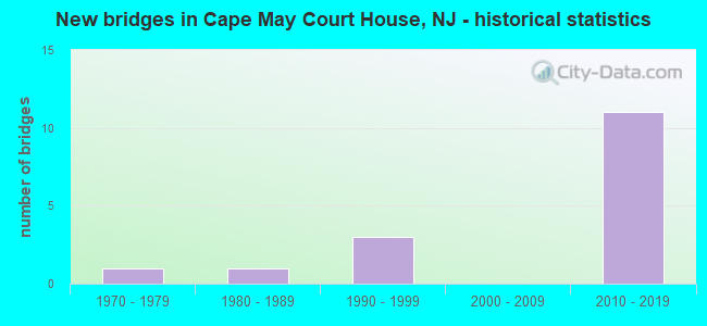
- New bridges - historical statistics
- 11970-1979
- 11980-1989
- 31990-1999
- 112010-2019


- Bridge Condition - Deck
- 12.5%Very good
- 87.5%Good

- Bridge Condition - Superstructure
- 37.5%Excellent
- 37.5%Very good
- 12.5%Good
- 12.5%Satisfactory

- Bridge Condition - Substructure
- 37.5%Very good
- 50.0%Good
- 12.5%Satisfactory

- Bridge Condition - Channel
- 60.0%Very good
- 20.0%Good
- 20.0%Fair

- Bridge Condition - Culverts
- 50.0%Satisfactory
- 50.0%Fair
Find on map >> Show street view
Structure Number: 500017, Location: 2 MI E OF PARKWAY EXIT (Lat: 39.067289, Lng: -74.792650), Route carried "on" structure: County highway 657, Year Built: 1998, Status: Open, Structure Length: 10.21m (33.50ft), Average Daily Traffic: 6,745 (year 2020), Truck Traffic: 3%, Average Future Daily Traffic: 8,100 (year 2040), Design Load: HS 20+Mod, Features Intersected: SCOTCH BONNET CREEK
Minimum Vertical Clearance: 30+ m (98+ ft), Kilometerpoint: 2.446, Lanes on structure: 2, Base Highway Network: Yes, Owner: County Highway Agency, Approaching Roadway Width: 12.2m (40.0ft), Material/Design: Prestressed concrete, Design/Construction: Box Beam or Girders - Multiple, Number Of Spans In Main Unit: 7, Length of Maximum Span: 14.6m (47.9ft), Curb-To-Curb Width: 12.2m (40.0ft), Out-to-Out Width: 13.4m (44.0ft)
Condition: Deck: Good, Superstructure: Very good, Substructure: Good, Channel: Very good, Operating Rating: 81.6 metric tons, Method Used To Determine Operating Rating: Load Factor (LF), Inventory Rating: 49.0 metric tons, Method Used To Determine Inventory Rating: Load Factor (LF), Structural Evaluation: Better than present minimum criteria, Deck Geometry: Somewhat better than minimum adequacy, Waterway Adequacy: Equal to present desirable criteria, Approach Roadway Alignment: Equal to present desirable criteria, Designated Inspection Frequency: Every 24 months, Underwater Inspection Frequency: Every 48 months, Inspection Date: June 2020, Underwater Inspection Date: August 2020, Deck Structure Type: Concrete Cast-file-Place, Wearing Surface/Protective System: Wearing Surface: Monolithic Concrete, Deck Protection: Epoxy Coated Reinforcing
Find on map >> Show street view
Structure Number: 500025, Location: 1 MI. SOUTH OF NJSH 47 (Lat: 39.155889, Lng: -74.823281), Route carried "on" structure: County highway 657, Year Built: 1977, Status: Open, Structure Length: 1.25m (4.10ft), Average Daily Traffic: 9,410 (year 2020), Truck Traffic: 3%, Average Future Daily Traffic: 11,480 (year 2040), Design Load: HS 20, Features Intersected: SLUICE CREEK
Minimum Vertical Clearance: 30+ m (98+ ft), Kilometerpoint: 13.953, Lanes on structure: 2, Owner: County Highway Agency, Approaching Roadway Width: 12.2m (40.0ft), Skew: 2 degrees, Material/Design: Concrete, Design/Construction: Culvert, Number Of Spans In Main Unit: 2, Length of Maximum Span: 5.5m (18.0ft), Curb or Sidewalk Widths: Left: 0.8m (2.6ft), Right: 0.8m (2.6ft), Curb-To-Curb Width: 12.2m (40.0ft), Out-to-Out Width: 14.4m (47.2ft)
Condition: Channel: Very good, Culverts: Satisfactory, Operating Rating: 45.4 metric tons, Method Used To Determine Operating Rating: Load Factor (LF), Inventory Rating: 27.2 metric tons, Method Used To Determine Inventory Rating: Load Factor (LF), Structural Evaluation: Equal to present minimum criteria, Deck Geometry: Somewhat better than minimum adequacy, Waterway Adequacy: Equal to present minimum criteria, Approach Roadway Alignment: Equal to present desirable criteria, Designated Inspection Frequency: Every 24 months, Inspection Date: June 2020, Deck Structure Type: Concrete Cast-file-Place, Wearing Surface/Protective System: Wearing Surface: Bituminous
Find on map >> Show street view
Structure Number: 500031, Location: 0.46 Mls East of Rt 47 (Lat: 39.097881, Lng: -74.866661), Route carried "on" structure: County highway 658, Year Built: 1982, Status: Open, Structure Length: 0.64m (2.10ft), Average Daily Traffic: 2,180 (year 2020), Truck Traffic: 4%, Average Future Daily Traffic: 2,660 (year 2040), Design Load: HS 20, Features Intersected: SKEETER ISLAND CREEK
Minimum Vertical Clearance: 30+ m (98+ ft), Kilometerpoint: 0.740, Lanes on structure: 2, Owner: County Highway Agency, Approaching Roadway Width: 11.9m (39.0ft), Material/Design: Concrete, Design/Construction: Culvert, Number Of Spans In Main Unit: 2, Length of Maximum Span: 3.0m (9.8ft), Curb-To-Curb Width: 11.9m (39.0ft), Out-to-Out Width: 14.8m (48.6ft)
Condition: Channel: Fair, Culverts: Fair, Operating Rating: 51.7 metric tons, Method Used To Determine Operating Rating: Field evaluation and documented engineering judgment, Inventory Rating: 30.8 metric tons, Method Used To Determine Inventory Rating: Field evaluation and documented engineering judgment, Structural Evaluation: Somewhat better than minimum adequacy, Deck Geometry: Somewhat better than minimum adequacy, Waterway Adequacy: Somewhat better than minimum adequacy, Approach Roadway Alignment: Equal to present desirable criteria, Designated Inspection Frequency: Every 24 months, Inspection Date: June 2020
Find on map >> Show street view
Structure Number: 507152, Location: 8.43 MILES NORTH OF US 9 (Lat: 39.117511, Lng: -74.867719), Route carried "on" structure: State highway 47, Year Built: 1992, Status: Open, Structure Length: 2.62m (8.60ft), Average Daily Traffic: 5,847 (year 2020), Truck Traffic: 4%, Average Future Daily Traffic: 7,017 (year 2040), Design Load: HS 20+Mod, Features Intersected: BIDWELLS CREEK
Minimum Vertical Clearance: 30+ m (98+ ft), Kilometerpoint: 19.521, Lanes on structure: 2, Base Highway Network: Yes, Owner: State Highway Agency, Approaching Roadway Width: 13.4m (44.0ft), Skew: 1 degrees, Material/Design: Prestressed concrete, Design/Construction: Box Beam or Girders - Multiple, Number Of Spans In Main Unit: 1, Length of Maximum Span: 25.3m (83.0ft), Curb or Sidewalk Widths: Left: 1.8m (5.9ft), Right: 0.0m, Curb-To-Curb Width: 13.4m (44.0ft), Out-to-Out Width: 16.1m (52.8ft)
Condition: Deck: Good, Superstructure: Very good, Substructure: Satisfactory, Channel: Good, Operating Rating: 76.2 metric tons, Method Used To Determine Operating Rating: Load Factor (LF), Inventory Rating: 45.4 metric tons, Method Used To Determine Inventory Rating: Load Factor (LF), Structural Evaluation: Equal to present minimum criteria, Deck Geometry: Equal to present minimum criteria, Waterway Adequacy: Equal to present desirable criteria, Approach Roadway Alignment: Superior to present desirable criteria, Designated Inspection Frequency: Every 24 months, Underwater Inspection Frequency: Every 48 months, Inspection Date: Febuary 2020, Underwater Inspection Date: June 2020, Deck Structure Type: Concrete Cast-file-Place, Wearing Surface/Protective System: Wearing Surface: Monolithic Concrete, Deck Protection: Epoxy Coated Reinforcing
Find on map >> Show street view
Structure Number: 517151, Location: 2.4 MI E OF RT9&147 JCT (Lat: 39.030069, Lng: -74.816711), Route carried "on" structure: State highway 147, Year Built: 1994, Status: Open, Structure Length: 84.52m (277.30ft), Average Daily Traffic: 9,742 (year 2020), Truck Traffic: 4%, Average Future Daily Traffic: 11,690 (year 2040), Design Load: HS 20+Mod, Features Intersected: GRASSY SOUND
Minimum Vertical Clearance: 30.45m (99.90ft), Kilometerpoint: 4.023, Lanes on structure: 4, Base Highway Network: Yes, Owner: State Highway Agency, Approaching Roadway Width: 22.6m (74.1ft), Skew: 30 degrees, Navigation Control: Yes ( Vertical Clearance: 16.8m (55.1ft), Horizontal Clearance: 30.5m (100.1ft)), Material/Design: Steel continuous, Design/Construction: Stringer/Multi-beam, Number Of Spans In Main Unit: 3, Number Of Approach Spans: 24, Length of Maximum Span: 51.8m (169.9ft), Curb-To-Curb Width: 22.6m (74.1ft), Out-to-Out Width: 24.2m (79.4ft)
Condition: Deck: Good, Superstructure: Satisfactory, Substructure: Good, Channel: Very good, Operating Rating: 78.0 metric tons, Method Used To Determine Operating Rating: Load Factor (LF), Inventory Rating: 46.3 metric tons, Method Used To Determine Inventory Rating: Load Factor (LF), Structural Evaluation: Equal to present minimum criteria, Deck Geometry: Superior to present desirable criteria, Waterway Adequacy: Equal to present desirable criteria, Approach Roadway Alignment: Equal to present minimum criteria, Designated Inspection Frequency: Every 24 months, Underwater Inspection Frequency: Every 48 months, Inspection Date: September 2020, Underwater Inspection Date: September 2020, Deck Structure Type: Concrete Cast-file-Place, Wearing Surface/Protective System: Wearing Surface: Monolithic Concrete, Deck Protection: Epoxy Coated Reinforcing
Find on map >> Show street view
Structure Number: 360084N, Location: 1.8 MI N OF GSP & NJ 147 (Lat: 39.066525, Lng: -74.830003), Route carried "on" structure: Other road GSP, Year Built: 2015, Status: Open, Structure Length: 2.74m (8.99ft), Average Daily Traffic: 12,154 (year 2021), Truck Traffic: 3%, Average Future Daily Traffic: 14,830 (year 2041), Design Load: HL 93, Features Intersected: Shell Bay Avenue
Minimum Vertical Clearance: 30+ m (98+ ft), Kilometerpoint: 13.518, Lanes on structure: 2, Lanes under structure: 3, Base Highway Network: Yes, Toll: On toll road, Owner: State Toll Authority, Approaching Roadway Width: 14.6m (47.9ft), Skew: 1 degrees, Material/Design: Steel, Design/Construction: Stringer/Multi-beam, Number Of Spans In Main Unit: 1, Length of Maximum Span: 26.8m (87.9ft), Curb-To-Curb Width: 14.6m (47.9ft), Out-to-Out Width: 15.8m (51.8ft)
Condition: Deck: Good, Superstructure: Very good, Substructure: Good, Operating Rating: 77.8 metric tons, Method Used To Determine Operating Rating: Load and Resistance Factor Rating (LRFR) rating reported by rating factor(RF) method using HL-93 loadings, Inventory Rating: 59.9 metric tons, Method Used To Determine Inventory Rating: Load and Resistance Factor Rating (LRFR) rating reported by rating factor(RF) method using HL-93 loadings, Structural Evaluation: Better than present minimum criteria, Deck Geometry: Superior to present desirable criteria, Underclear: Superior to present desirable criteria, Approach Roadway Alignment: Superior to present desirable criteria, Designated Inspection Frequency: Every 24 months, Inspection Date: May 2021, Deck Structure Type: Concrete Cast-file-Place, Wearing Surface/Protective System: Wearing Surface: Monolithic Concrete, Deck Protection: Epoxy Coated Reinforcing
Find on map >> Show street view
Structure Number: 360084S, Location: 1.8 MI N OF GSP & NJ 147 (Lat: 39.066936, Lng: -74.830072), Route carried "on" structure: Other road GSP, Year Built: 2015, Status: Open, Structure Length: 2.74m (8.99ft), Average Daily Traffic: 19,500 (year 2021), Truck Traffic: 3%, Average Future Daily Traffic: 23,794 (year 2041), Design Load: HL 93, Features Intersected: Shell Bay Avenue
Minimum Vertical Clearance: 30+ m (98+ ft), Kilometerpoint: 13.518, Lanes on structure: 2, Lanes under structure: 3, Base Highway Network: Yes, Toll: On toll road, Owner: State Toll Authority, Approaching Roadway Width: 14.6m (47.9ft), Skew: 1 degrees, Material/Design: Steel, Design/Construction: Stringer/Multi-beam, Number Of Spans In Main Unit: 1, Length of Maximum Span: 26.8m (87.9ft), Curb-To-Curb Width: 14.6m (47.9ft), Out-to-Out Width: 15.8m (51.8ft)
Condition: Deck: Very good, Superstructure: Good, Substructure: Very good, Operating Rating: 77.8 metric tons, Method Used To Determine Operating Rating: Load and Resistance Factor Rating (LRFR) rating reported by rating factor(RF) method using HL-93 loadings, Inventory Rating: 59.9 metric tons, Method Used To Determine Inventory Rating: Load and Resistance Factor Rating (LRFR) rating reported by rating factor(RF) method using HL-93 loadings, Structural Evaluation: Better than present minimum criteria, Deck Geometry: Superior to present desirable criteria, Underclear: Superior to present desirable criteria, Approach Roadway Alignment: Equal to present desirable criteria, Designated Inspection Frequency: Every 24 months, Inspection Date: May 2021, Deck Structure Type: Concrete Cast-file-Place, Wearing Surface/Protective System: Wearing Surface: Monolithic Concrete, Deck Protection: Epoxy Coated Reinforcing
Find on map >> Show street view
Structure Number: 360099S, Location: 3.3 MI N OF GSP & NJ 147 (Lat: 39.085594, Lng: -74.815147), Route carried "on" structure: Other road GSP, Year Built: 2015, Status: Open, Structure Length: 4.36m (14.30ft), Average Daily Traffic: 11,505 (year 2021), Truck Traffic: 3%, Average Future Daily Traffic: 14,038 (year 2041), Design Load: HL 93, Features Intersected: Stone Harbor Blvd(CR657)
Minimum Vertical Clearance: 30+ m (98+ ft), Kilometerpoint: 15.933, Lanes on structure: 2, Lanes under structure: 5, Base Highway Network: Yes, Toll: On toll road, Owner: State Toll Authority, Approaching Roadway Width: 14.6m (47.9ft), Material/Design: Steel, Design/Construction: Stringer/Multi-beam, Number Of Spans In Main Unit: 1, Length of Maximum Span: 42.7m (140.1ft), Curb-To-Curb Width: 14.6m (47.9ft), Out-to-Out Width: 15.8m (51.8ft)
Condition: Deck: Good, Superstructure: Excellent, Substructure: Very good, Operating Rating: 80.0 metric tons, Method Used To Determine Operating Rating: Load and Resistance Factor Rating (LRFR) rating reported by rating factor(RF) method using HL-93 loadings, Inventory Rating: 61.9 metric tons, Method Used To Determine Inventory Rating: Load and Resistance Factor Rating (LRFR) rating reported by rating factor(RF) method using HL-93 loadings, Structural Evaluation: Equal to present desirable criteria, Deck Geometry: Superior to present desirable criteria, Underclear: Better than present minimum criteria, Approach Roadway Alignment: Equal to present desirable criteria, Designated Inspection Frequency: Every 24 months, Inspection Date: May 2021, Deck Structure Type: Concrete Cast-file-Place, Wearing Surface/Protective System: Wearing Surface: Monolithic Concrete, Deck Protection: Epoxy Coated Reinforcing
Find on map >> Show street view
Structure Number: 360110N, Location: 2.6 MI S. OF GSP & CR 601 (Lat: 39.100069, Lng: -74.805644), Route carried "on" structure: Other road GSP, Year Built: 2015, Status: Open, Structure Length: 3.20m (10.50ft), Average Daily Traffic: 18,231 (year 2021), Truck Traffic: 3%, Average Future Daily Traffic: 22,245 (year 2041), Design Load: HL 93, Features Intersected: Crest Haven Road
Minimum Vertical Clearance: 30+ m (98+ ft), Kilometerpoint: 17.767, Lanes on structure: 2, Lanes under structure: 4, Base Highway Network: Yes, Toll: On toll road, Owner: State Toll Authority, Approaching Roadway Width: 14.6m (47.9ft), Skew: 1 degrees, Material/Design: Steel, Design/Construction: Stringer/Multi-beam, Number Of Spans In Main Unit: 1, Length of Maximum Span: 31.4m (103.0ft), Curb-To-Curb Width: 14.6m (47.9ft), Out-to-Out Width: 15.8m (51.8ft)
Condition: Deck: Good, Superstructure: Excellent, Substructure: Good, Operating Rating: 70.3 metric tons, Method Used To Determine Operating Rating: Load and Resistance Factor Rating (LRFR) rating reported by rating factor(RF) method using HL-93 loadings, Inventory Rating: 54.1 metric tons, Method Used To Determine Inventory Rating: Load and Resistance Factor Rating (LRFR) rating reported by rating factor(RF) method using HL-93 loadings, Structural Evaluation: Better than present minimum criteria, Deck Geometry: Superior to present desirable criteria, Underclear: Equal to present minimum criteria, Approach Roadway Alignment: Equal to present desirable criteria, Designated Inspection Frequency: Every 24 months, Inspection Date: May 2021, Deck Structure Type: Concrete Cast-file-Place, Wearing Surface/Protective System: Wearing Surface: Monolithic Concrete, Deck Protection: Epoxy Coated Reinforcing
Find on map >> Show street view
Structure Number: 360110S, Location: 2.56 MI S OF GSP & CR 601 (Lat: 39.100111, Lng: -74.805900), Route carried "on" structure: Other road GSP, Year Built: 2015, Status: Open, Structure Length: 3.20m (10.50ft), Average Daily Traffic: 11,505 (year 2021), Truck Traffic: 3%, Average Future Daily Traffic: 14,038 (year 2041), Design Load: HL 93, Features Intersected: Crest Haven Road(CR 609)
Minimum Vertical Clearance: 30+ m (98+ ft), Kilometerpoint: 17.767, Lanes on structure: 2, Lanes under structure: 3, Base Highway Network: Yes, Toll: On toll road, Owner: State Toll Authority, Approaching Roadway Width: 14.6m (47.9ft), Skew: 1 degrees, Material/Design: Steel, Design/Construction: Stringer/Multi-beam, Number Of Spans In Main Unit: 1, Length of Maximum Span: 31.4m (103.0ft), Curb-To-Curb Width: 14.6m (47.9ft), Out-to-Out Width: 15.8m (51.8ft)
Condition: Deck: Good, Superstructure: Excellent, Substructure: Very good, Operating Rating: 70.3 metric tons, Method Used To Determine Operating Rating: Load and Resistance Factor Rating (LRFR) rating reported by rating factor(RF) method using HL-93 loadings, Inventory Rating: 54.1 metric tons, Method Used To Determine Inventory Rating: Load and Resistance Factor Rating (LRFR) rating reported by rating factor(RF) method using HL-93 loadings, Structural Evaluation: Equal to present desirable criteria, Deck Geometry: Superior to present desirable criteria, Underclear: Better than present minimum criteria, Approach Roadway Alignment: Equal to present desirable criteria, Designated Inspection Frequency: Every 24 months, Inspection Date: May 2021, Deck Structure Type: Concrete Cast-file-Place, Wearing Surface/Protective System: Wearing Surface: Monolithic Concrete, Deck Protection: Epoxy Coated Reinforcing
Find on map >> Show street view
Structure Number: 360084N, Location: 1.8 MI N OF GSP & NJ 147 (Lat: 39.066525, Lng: -74.830003), Route carried "under" structure: City street , Year Built: 2015, Structure Length: 0. m, Average Daily Traffic: 2,395 (year 2021), Truck Traffic: 1%, Features Intersected: Shell Bay Avenue, Facility Carried by Structure: GSP Northbound
Minimum Vertical Clearance: 5.11m (16.77ft), Kilometerpoint: 0.145, Lanes on structure: 2, Lanes under structure: 3, Material/Design: Steel, Design/Construction: Stringer/Multi-beam, Length of Maximum Span: 26.8m (87.9ft)
Find on map >> Show street view
Structure Number: 360084S, Location: 1.8 MI N OF GSP & NJ 147 (Lat: 39.066936, Lng: -74.830072), Route carried "under" structure: City street , Year Built: 2015, Structure Length: 0. m, Average Daily Traffic: 2,395 (year 2021), Truck Traffic: 1%, Features Intersected: Shell Bay Avenue, Facility Carried by Structure: GSP Southbound
Minimum Vertical Clearance: 5.08m (16.67ft), Kilometerpoint: 0.145, Lanes on structure: 2, Lanes under structure: 3, Material/Design: Steel, Design/Construction: Stringer/Multi-beam, Length of Maximum Span: 26.8m (87.9ft)
Find on map >> Show street view
Structure Number: 360099N, Location: 1.1 MI S OF GSP & CR 609 (Lat: 39.084964, Lng: -74.815172), Route carried "under" structure: County highway 657, Year Built: 2015, Structure Length: 0. m, Average Daily Traffic: 7,780 (year 2021), Truck Traffic: 4%, Features Intersected: Stone Harbor Blvd, Facility Carried by Structure: GSP Northbound
Minimum Vertical Clearance: 5.54m (18.18ft), Kilometerpoint: 5.842, Lanes on structure: 2, Lanes under structure: 4, Material/Design: Steel, Design/Construction: Stringer/Multi-beam, Length of Maximum Span: 42.7m (140.1ft)
Find on map >> Show street view
Structure Number: 360099S, Location: 3.3 MI N OF GSP & NJ 147 (Lat: 39.085594, Lng: -74.815147), Route carried "under" structure: County highway 657, Year Built: 2015, Structure Length: 0. m, Average Daily Traffic: 7,780 (year 2021), Truck Traffic: 4%, Features Intersected: Stone Harbor Blvd(CR657), Facility Carried by Structure: GSP Southbound
Minimum Vertical Clearance: 5.39m (17.68ft), Kilometerpoint: 5.842, Lanes on structure: 2, Lanes under structure: 5, Material/Design: Steel, Design/Construction: Stringer/Multi-beam, Length of Maximum Span: 42.7m (140.1ft)
Find on map >> Show street view
Structure Number: 360110N, Location: 2.6 MI S. OF GSP & CR 601 (Lat: 39.100069, Lng: -74.805644), Route carried "under" structure: County highway 609, Year Built: 2015, Structure Length: 0. m, Average Daily Traffic: 9,213 (year 2021), Truck Traffic: 1%, Features Intersected: Crest Haven Road, Facility Carried by Structure: GSP Northbound
Minimum Vertical Clearance: 4.98m (16.34ft), Kilometerpoint: 0.402, Lanes on structure: 2, Lanes under structure: 4, Material/Design: Steel, Design/Construction: Stringer/Multi-beam, Length of Maximum Span: 31.4m (103.0ft)
Find on map >> Show street view
Structure Number: 360110S, Location: 2.56 MI S OF GSP & CR 601 (Lat: 39.100111, Lng: -74.805900), Route carried "under" structure: County highway 609, Year Built: 2015, Structure Length: 0. m, Average Daily Traffic: 9,213 (year 2021), Truck Traffic: 2%, Features Intersected: Crest Haven Road(CR 609), Facility Carried by Structure: GSP Southbound
Minimum Vertical Clearance: 5.05m (16.57ft), Kilometerpoint: 0.402, Lanes on structure: 2, Lanes under structure: 3, Material/Design: Steel, Design/Construction: Stringer/Multi-beam, Length of Maximum Span: 31.4m (103.0ft)