Bridge Statistics for Carlisle, Pennsylvania (PA)
Condition, Traffic, Stress, Structural Evaluation, Project Costs
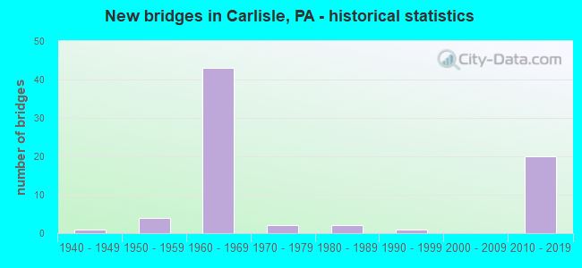
- New bridges - historical statistics
- 11940-1949
- 41950-1959
- 431960-1969
- 21970-1979
- 21980-1989
- 11990-1999
- 202010-2019
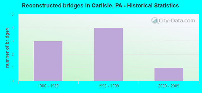
- Reconstructed bridges - Historical Statistics
- 31980-1989
- 41990-1999
- 12000-2009
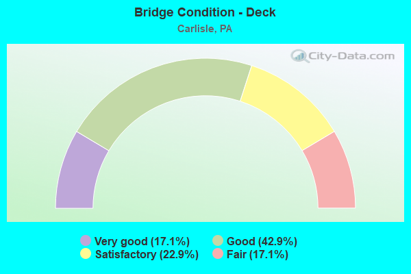
- Bridge Condition - Deck
- 17.1%Very good
- 42.9%Good
- 22.9%Satisfactory
- 17.1%Fair
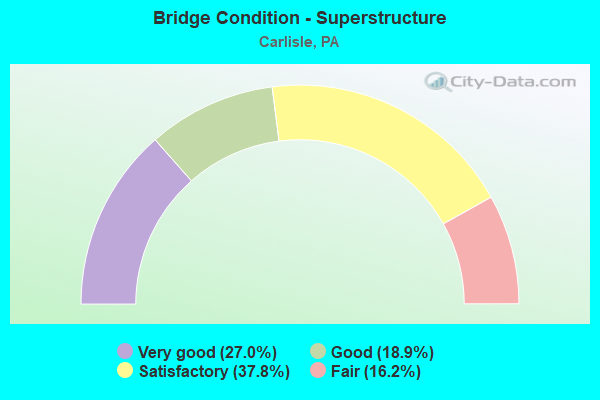
- Bridge Condition - Superstructure
- 27.0%Very good
- 18.9%Good
- 37.8%Satisfactory
- 16.2%Fair
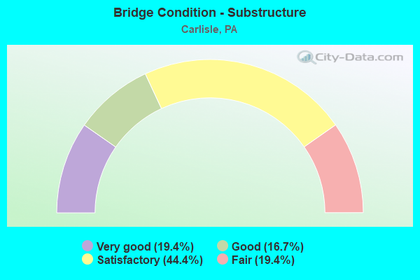
- Bridge Condition - Substructure
- 19.4%Very good
- 16.7%Good
- 44.4%Satisfactory
- 19.4%Fair
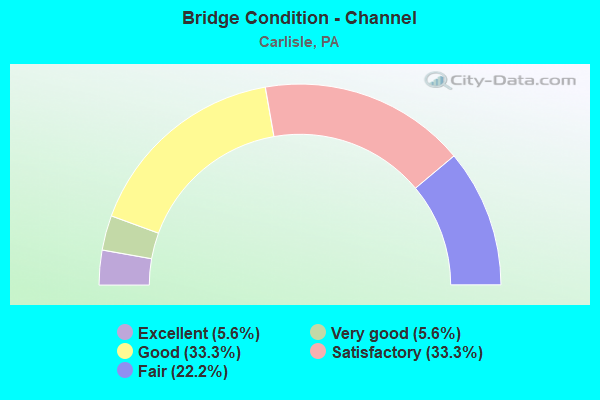
- Bridge Condition - Channel
- 5.6%Excellent
- 5.6%Very good
- 33.3%Good
- 33.3%Satisfactory
- 22.2%Fair
Find on map >> Show street view
Structure Number: 13663, Location: 3 MI.S. OF CARLISLE (Lat: 40.175231, Lng: -77.257089), Route carried "under" structure: City street , Year Built: 1963, Structure Length: 0. m, Average Daily Traffic: 125 (year 1980), Truck Traffic: 5%, Features Intersected: T-480; SHAGBARK LN, Facility Carried by Structure: I-81 SB; SR 0081
Minimum Vertical Clearance: 4.60m (15.09ft), Kilometerpoint: 0.000, Lanes on structure: 2, Lanes under structure: 2, Material/Design: Prestressed concrete, Design/Construction: Box Beam or Girders - Single/Spread, Length of Maximum Span: 10.4m (34.1ft)
Find on map >> Show street view
Structure Number: 13668, Location: COLLEGE ST. EXIT 13 (Lat: 40.187092, Lng: -77.208211), Route carried "under" structure: State highway , Year Built: 1962, Structure Length: 0. m, Average Daily Traffic: 4,607 (year 2021), Truck Traffic: 1%, Features Intersected: WALNUT BOTTOM RD., Facility Carried by Structure: I-81 NB; SR 0081
Minimum Vertical Clearance: 4.54m (14.90ft), Kilometerpoint: 2.665, Lanes on structure: 2, Lanes under structure: 4, Material/Design: Steel, Design/Construction: Stringer/Multi-beam, Length of Maximum Span: 35.4m (116.1ft)
Find on map >> Show street view
Structure Number: 13668, Location: COLLEGE ST. EXIT 13 (Lat: 40.187092, Lng: -77.208211), Route carried "under" structure: State highway , Year Built: 1962, Structure Length: 0. m, Average Daily Traffic: 4,607 (year 2021), Truck Traffic: 1%, Features Intersected: WALNUT BOTTOM RD., Facility Carried by Structure: I-81 NB; SR 0081
Minimum Vertical Clearance: 4.52m (14.83ft), Kilometerpoint: 2.665, Lanes on structure: 2, Lanes under structure: 4, Material/Design: Steel, Design/Construction: Stringer/Multi-beam, Length of Maximum Span: 35.4m (116.1ft)
Find on map >> Show street view
Structure Number: 13669, Location: COLLEGE ST.;EXIT 13 (Lat: 40.187339, Lng: -77.207861), Route carried "under" structure: State highway , Year Built: 1962, Structure Length: 0. m, Average Daily Traffic: 4,607 (year 2021), Truck Traffic: 1%, Features Intersected: WALNUT BOTTOM RD.SR 3023, Facility Carried by Structure: I-81 SB; SR 0081
Minimum Vertical Clearance: 4.72m (15.49ft), Kilometerpoint: 2.665, Lanes on structure: 2, Lanes under structure: 4, Material/Design: Steel, Design/Construction: Stringer/Multi-beam, Length of Maximum Span: 35.4m (116.1ft)
Find on map >> Show street view
Structure Number: 13669, Location: COLLEGE ST.;EXIT 13 (Lat: 40.187339, Lng: -77.207861), Route carried "under" structure: State highway , Year Built: 1962, Structure Length: 0. m, Average Daily Traffic: 4,607 (year 2021), Truck Traffic: 1%, Features Intersected: WALNUT BOTTOM RD.SR 3023, Facility Carried by Structure: I-81 SB; SR 0081
Minimum Vertical Clearance: 4.80m (15.75ft), Kilometerpoint: 2.665, Lanes on structure: 2, Lanes under structure: 4, Material/Design: Steel, Design/Construction: Stringer/Multi-beam, Length of Maximum Span: 35.4m (116.1ft)
Find on map >> Show street view
Structure Number: 1367, Location: W.RIDGE ST.(CARLISLE) (Lat: 40.187633, Lng: -77.197967), Route carried "under" structure: Interstate 81, Year Built: 1962, Structure Length: 0. m, Average Daily Traffic: 26,331 (year 2021), Truck Traffic: 40%, Features Intersected: I-81; SR 0081, Facility Carried by Structure: WEST RIDGE STREET
Minimum Vertical Clearance: 5.08m (16.67ft), Kilometerpoint: 32.530, Lanes on structure: 2, Lanes under structure: 4, Material/Design: Prestressed concrete, Design/Construction: Box Beam or Girders - Single/Spread, Length of Maximum Span: 20.1m (65.9ft)
Find on map >> Show street view
Structure Number: 1367, Location: W.RIDGE ST.(CARLISLE) (Lat: 40.187633, Lng: -77.197967), Route carried "under" structure: Interstate 81, Year Built: 1962, Structure Length: 0. m, Average Daily Traffic: 30,028 (year 2021), Truck Traffic: 35%, Features Intersected: I-81; SR 0081, Facility Carried by Structure: WEST RIDGE STREET
Minimum Vertical Clearance: 4.95m (16.24ft), Kilometerpoint: 32.544, Lanes on structure: 2, Lanes under structure: 4, Material/Design: Prestressed concrete, Design/Construction: Box Beam or Girders - Single/Spread, Length of Maximum Span: 20.1m (65.9ft)
Find on map >> Show street view
Structure Number: 13671, Location: I-81 OVER PA 34, EXIT 14 (Lat: 40.187775, Lng: -77.191158), Route carried "under" structure: State highway 34, Year Built: 1962, Structure Length: 0. m, Average Daily Traffic: 5,585 (year 2020), Truck Traffic: 5%, Features Intersected: HANOVER ST; PA 34, Facility Carried by Structure: I-81 NB; SR 0081
Minimum Vertical Clearance: 4.44m (14.57ft), Kilometerpoint: 18.704, Lanes on structure: 2, Lanes under structure: 4, Material/Design: Prestressed concrete, Design/Construction: Box Beam or Girders - Single/Spread, Length of Maximum Span: 21.6m (70.9ft)
Find on map >> Show street view
Structure Number: 13671, Location: I-81 OVER PA 34, EXIT 14 (Lat: 40.187775, Lng: -77.191158), Route carried "under" structure: State highway 34, Year Built: 1962, Structure Length: 0. m, Average Daily Traffic: 5,727 (year 2020), Truck Traffic: 4%, Features Intersected: HANOVER ST; PA 34, Facility Carried by Structure: I-81 NB; SR 0081
Minimum Vertical Clearance: 4.42m (14.50ft), Kilometerpoint: 18.702, Lanes on structure: 2, Lanes under structure: 4, Material/Design: Prestressed concrete, Design/Construction: Box Beam or Girders - Single/Spread, Length of Maximum Span: 21.6m (70.9ft)
Find on map >> Show street view
Structure Number: 13673, Location: 0.3 MI.NORTH OF PA 34 (Lat: 40.188442, Lng: -77.184397), Route carried "under" structure: City street , Year Built: 1962, Structure Length: 0. m, Average Daily Traffic: 125 (year 1980), Truck Traffic: 1%, Features Intersected: SPRING GARDEN; T-516, Facility Carried by Structure: I-81 NB; SR 0081
Minimum Vertical Clearance: 5.00m (16.40ft), Kilometerpoint: 0.000, Lanes on structure: 2, Lanes under structure: 2, Material/Design: Prestressed concrete, Design/Construction: Box Beam or Girders - Single/Spread, Length of Maximum Span: 11.0m (36.1ft)
Find on map >> Show street view
Structure Number: 13676, Location: I-81 OVER PA 34 (Lat: 40.188000, Lng: -77.191119), Route carried "under" structure: State highway 34, Year Built: 1962, Structure Length: 0. m, Average Daily Traffic: 5,585 (year 2020), Truck Traffic: 5%, Features Intersected: PA 34; SR 0034, Facility Carried by Structure: I-81 SB; SR 0081
Minimum Vertical Clearance: 4.65m (15.26ft), Kilometerpoint: 18.704, Lanes on structure: 3, Lanes under structure: 4, Material/Design: Prestressed concrete, Design/Construction: Box Beam or Girders - Single/Spread, Length of Maximum Span: 21.6m (70.9ft)
Find on map >> Show street view
Structure Number: 13676, Location: I-81 OVER PA 34 (Lat: 40.188000, Lng: -77.191119), Route carried "under" structure: State highway 34, Year Built: 1962, Structure Length: 0. m, Average Daily Traffic: 5,727 (year 2020), Truck Traffic: 4%, Features Intersected: PA 34; SR 0034, Facility Carried by Structure: I-81 SB; SR 0081
Minimum Vertical Clearance: 4.67m (15.32ft), Kilometerpoint: 18.702, Lanes on structure: 3, Lanes under structure: 4, Material/Design: Prestressed concrete, Design/Construction: Box Beam or Girders - Single/Spread, Length of Maximum Span: 21.6m (70.9ft)
Find on map >> Show street view
Structure Number: 13679, Location: 0.3 MI.N. OF PA 34 (Lat: 40.188675, Lng: -77.184319), Route carried "under" structure: City street , Year Built: 1962, Structure Length: 0. m, Average Daily Traffic: 125 (year 1980), Truck Traffic: 1%, Features Intersected: T-516; SPRING GARDEN ST., Facility Carried by Structure: I-81 SB; SR 0081
Minimum Vertical Clearance: 4.70m (15.42ft), Kilometerpoint: 0.000, Lanes on structure: 2, Lanes under structure: 2, Material/Design: Prestressed concrete, Design/Construction: Box Beam or Girders - Single/Spread, Length of Maximum Span: 11.0m (36.1ft)
Find on map >> Show street view
Structure Number: 1368, Location: .25 MI.S. OF EXIT 47 (Lat: 40.191511, Lng: -77.168128), Route carried "under" structure: State highway 2001, Year Built: 1963, Structure Length: 0. m, Average Daily Traffic: 2,065 (year 2001), Truck Traffic: 3%, Features Intersected: PETERSBURG RD.; SR 2001, Facility Carried by Structure: I-81 NB; SR 0081
Minimum Vertical Clearance: 5.36m (17.59ft), Kilometerpoint: 0.000, Lanes on structure: 3, Lanes under structure: 2, Material/Design: Prestressed concrete, Design/Construction: Box Beam or Girders - Single/Spread, Length of Maximum Span: 10.7m (35.1ft)
Find on map >> Show street view
Structure Number: 13681, Location: 0.25 MI.S. OF PA 74 (Lat: 40.191747, Lng: -77.168225), Route carried "under" structure: State highway 2001, Year Built: 1963, Structure Length: 0. m, Average Daily Traffic: 2,065 (year 2001), Truck Traffic: 3%, Features Intersected: PETERSBURG RD; SR 2001, Facility Carried by Structure: I-81
Minimum Vertical Clearance: 5.87m (19.26ft), Kilometerpoint: 0.000, Lanes on structure: 3, Lanes under structure: 2, Material/Design: Prestressed concrete, Design/Construction: Box Beam or Girders - Single/Spread, Length of Maximum Span: 10.7m (35.1ft)
Find on map >> Show street view
Structure Number: 13682, Location: I-81 OVER PA 74 (Lat: 40.193314, Lng: -77.164033), Route carried "under" structure: State highway 74, Year Built: 1962, Structure Length: 0. m, Average Daily Traffic: 5,586 (year 2021), Truck Traffic: 4%, Features Intersected: PA 74;SR 0074, Facility Carried by Structure: I-81 NB; SR 0081
Minimum Vertical Clearance: 4.98m (16.34ft), Kilometerpoint: 11.940, Lanes on structure: 2, Lanes under structure: 4, Material/Design: Prestressed concrete, Design/Construction: Box Beam or Girders - Single/Spread, Length of Maximum Span: 21.9m (71.9ft)
Find on map >> Show street view
Structure Number: 13682, Location: I-81 OVER PA 74 (Lat: 40.193314, Lng: -77.164033), Route carried "under" structure: State highway 74, Year Built: 1962, Structure Length: 0. m, Average Daily Traffic: 5,586 (year 2021), Truck Traffic: 4%, Features Intersected: PA 74;SR 0074, Facility Carried by Structure: I-81 NB; SR 0081
Minimum Vertical Clearance: 5.13m (16.83ft), Kilometerpoint: 11.940, Lanes on structure: 2, Lanes under structure: 4, Material/Design: Prestressed concrete, Design/Construction: Box Beam or Girders - Single/Spread, Length of Maximum Span: 21.9m (71.9ft)
Find on map >> Show street view
Structure Number: 13683, Location: I-81 & PA 74 INTER (Lat: 40.193397, Lng: -77.164403), Route carried "under" structure: State highway 74, Year Built: 1962, Structure Length: 0. m, Average Daily Traffic: 5,586 (year 2021), Truck Traffic: 4%, Features Intersected: PA-74; SR 0074, Facility Carried by Structure: I-81 SB; SR 0081
Minimum Vertical Clearance: 5.03m (16.50ft), Kilometerpoint: 11.940, Lanes on structure: 2, Lanes under structure: 4, Material/Design: Prestressed concrete, Design/Construction: Box Beam or Girders - Single/Spread, Length of Maximum Span: 21.9m (71.9ft)
Find on map >> Show street view
Structure Number: 13683, Location: I-81 & PA 74 INTER (Lat: 40.193397, Lng: -77.164403), Route carried "under" structure: State highway 74, Year Built: 1962, Structure Length: 0. m, Average Daily Traffic: 5,586 (year 2021), Truck Traffic: 4%, Features Intersected: PA-74; SR 0074, Facility Carried by Structure: I-81 SB; SR 0081
Minimum Vertical Clearance: 5.13m (16.83ft), Kilometerpoint: 11.940, Lanes on structure: 2, Lanes under structure: 4, Material/Design: Prestressed concrete, Design/Construction: Box Beam or Girders - Single/Spread, Length of Maximum Span: 21.9m (71.9ft)
Find on map >> Show street view
Structure Number: 13684, Location: I-81 OVER PA 641 (Lat: 40.199197, Lng: -77.158586), Route carried "under" structure: State highway 641, Year Built: 1963, Structure Length: 0. m, Average Daily Traffic: 4,997 (year 2020), Truck Traffic: 4%, Features Intersected: 641; Trindle Rd, Facility Carried by Structure: I-81 NB; SR 0081
Minimum Vertical Clearance: 4.82m (15.81ft), Kilometerpoint: 35.425, Lanes on structure: 3, Lanes under structure: 4, Material/Design: Prestressed concrete, Design/Construction: Box Beam or Girders - Single/Spread, Length of Maximum Span: 22.6m (74.1ft)
Find on map >> Show street view
Structure Number: 13684, Location: I-81 OVER PA 641 (Lat: 40.199197, Lng: -77.158586), Route carried "under" structure: State highway 641, Year Built: 1963, Structure Length: 0. m, Average Daily Traffic: 6,752 (year 2022), Truck Traffic: 4%, Features Intersected: 641; Trindle Rd, Facility Carried by Structure: I-81 NB; SR 0081
Minimum Vertical Clearance: 4.85m (15.91ft), Kilometerpoint: 35.425, Lanes on structure: 3, Lanes under structure: 4, Material/Design: Prestressed concrete, Design/Construction: Box Beam or Girders - Single/Spread, Length of Maximum Span: 22.6m (74.1ft)
Find on map >> Show street view
Structure Number: 13685, Location: 0.5 MI.N. OF PA 641 (Lat: 40.206133, Lng: -77.156419), Route carried "under" structure: Interstate 81, Year Built: 1963, Structure Length: 0. m, Average Daily Traffic: 35,598 (year 2021), Truck Traffic: 25%, Features Intersected: I-81; SR 0081, Facility Carried by Structure: T-512; CLAREMT DR.
Minimum Vertical Clearance: 5.11m (16.77ft), Kilometerpoint: 36.506, Lanes on structure: 2, Lanes under structure: 4, Material/Design: Steel continuous, Design/Construction: Stringer/Multi-beam, Length of Maximum Span: 22.9m (75.1ft)
Find on map >> Show street view
Structure Number: 13685, Location: 0.5 MI.N. OF PA 641 (Lat: 40.206133, Lng: -77.156419), Route carried "under" structure: Interstate 81, Year Built: 1963, Structure Length: 0. m, Average Daily Traffic: 35,251 (year 2021), Truck Traffic: 26%, Features Intersected: I-81; SR 0081, Facility Carried by Structure: T-512; CLAREMT DR.
Minimum Vertical Clearance: 5.11m (16.77ft), Kilometerpoint: 36.587, Lanes on structure: 2, Lanes under structure: 4, Material/Design: Steel continuous, Design/Construction: Stringer/Multi-beam, Length of Maximum Span: 22.9m (75.1ft)
Find on map >> Show street view
Structure Number: 13686, Location: I-81 OVER PA 641 (Lat: 40.199136, Lng: -77.158939), Route carried "under" structure: State highway 641, Year Built: 1963, Structure Length: 0. m, Average Daily Traffic: 4,997 (year 2020), Truck Traffic: 4%, Features Intersected: PA 641; SR 0641, Facility Carried by Structure: I-81 SB; SR 0081
Minimum Vertical Clearance: 4.90m (16.08ft), Kilometerpoint: 35.425, Lanes on structure: 2, Lanes under structure: 4, Material/Design: Prestressed concrete, Design/Construction: Box Beam or Girders - Single/Spread, Length of Maximum Span: 22.6m (74.1ft)
Find on map >> Show street view
Structure Number: 13686, Location: I-81 OVER PA 641 (Lat: 40.199136, Lng: -77.158939), Route carried "under" structure: State highway 641, Year Built: 1963, Structure Length: 0. m, Average Daily Traffic: 6,752 (year 2022), Truck Traffic: 4%, Features Intersected: PA 641; SR 0641, Facility Carried by Structure: I-81 SB; SR 0081
Minimum Vertical Clearance: 4.93m (16.17ft), Kilometerpoint: 35.425, Lanes on structure: 2, Lanes under structure: 4, Material/Design: Prestressed concrete, Design/Construction: Box Beam or Girders - Single/Spread, Length of Maximum Span: 22.6m (74.1ft)
Find on map >> Show street view
Structure Number: 46694, Location: 1 MI. S. OF CARLISLE (Lat: 40.184639, Lng: -77.238278), Route carried "under" structure: State highway 465, Year Built: 2011, Structure Length: 0. m, Average Daily Traffic: 5,021 (year 2019), Truck Traffic: 17%, Features Intersected: PA 465; SR 0465, Facility Carried by Structure: I-81 NB; SR 0081
Minimum Vertical Clearance: 4.80m (15.75ft), Kilometerpoint: 8.755, Lanes on structure: 3, Lanes under structure: 6, Material/Design: Prestressed concrete, Design/Construction: Stringer/Multi-beam, Length of Maximum Span: 34.4m (112.9ft)
Find on map >> Show street view
Structure Number: 46694, Location: 1 MI. S. OF CARLISLE (Lat: 40.184639, Lng: -77.238278), Route carried "under" structure: State highway 465, Year Built: 2011, Structure Length: 0. m, Average Daily Traffic: 4,616 (year 2019), Truck Traffic: 16%, Features Intersected: PA 465; SR 0465, Facility Carried by Structure: I-81 NB; SR 0081
Minimum Vertical Clearance: 4.93m (16.17ft), Kilometerpoint: 8.753, Lanes on structure: 3, Lanes under structure: 6, Material/Design: Prestressed concrete, Design/Construction: Stringer/Multi-beam, Length of Maximum Span: 34.4m (112.9ft)
Find on map >> Show street view
Structure Number: 46695, Location: 1 MI. S. OF CARLISLE (Lat: 40.184861, Lng: -77.238472), Route carried "under" structure: State highway 465, Year Built: 2011, Structure Length: 0. m, Average Daily Traffic: 4,616 (year 2019), Truck Traffic: 16%, Features Intersected: PA 465; SR 0465, Facility Carried by Structure: I-81 SB; SR 0081
Minimum Vertical Clearance: 4.93m (16.17ft), Kilometerpoint: 8.753, Lanes on structure: 2, Lanes under structure: 3, Material/Design: Prestressed concrete, Design/Construction: Stringer/Multi-beam, Length of Maximum Span: 34.4m (112.9ft)
Find on map >> Show street view
Structure Number: 46695, Location: 1 MI. S. OF CARLISLE (Lat: 40.184861, Lng: -77.238472), Route carried "under" structure: State highway 465, Year Built: 2011, Structure Length: 0. m, Average Daily Traffic: 5,021 (year 2019), Truck Traffic: 17%, Features Intersected: PA 465; SR 0465, Facility Carried by Structure: I-81 SB; SR 0081
Minimum Vertical Clearance: 4.80m (15.75ft), Kilometerpoint: 8.755, Lanes on structure: 2, Lanes under structure: 3, Material/Design: Prestressed concrete, Design/Construction: Stringer/Multi-beam, Length of Maximum Span: 34.4m (112.9ft)
Find on map >> Show street view
Structure Number: 47884, Location: LEMOYNE WEST OF LR250 (Lat: 40.236617, Lng: -76.894111), Route carried "under" structure: Ramp State highway , Year Built: 2013, Structure Length: 0. m, Average Daily Traffic: 3,124 (year 2021), Truck Traffic: 10%, Features Intersected: I-83, SR 0083, Facility Carried by Structure: SR 2028
Minimum Vertical Clearance: 5.03m (16.50ft), Kilometerpoint: 0.000, Lanes on structure: 4, Lanes under structure: 1, Material/Design: Steel continuous, Design/Construction: Stringer/Multi-beam, Length of Maximum Span: 57.3m (188.0ft)
Find on map >> Show street view
Structure Number: 47884, Location: LEMOYNE WEST OF LR250 (Lat: 40.236617, Lng: -76.894111), Route carried "under" structure: Interstate 83, Year Built: 2013, Structure Length: 0. m, Average Daily Traffic: 37,846 (year 2021), Truck Traffic: 14%, Features Intersected: I-83, SR 0083, Facility Carried by Structure: SR 2028
Minimum Vertical Clearance: 5.03m (16.50ft), Kilometerpoint: 2.208, Lanes on structure: 4, Lanes under structure: 3, Material/Design: Steel continuous, Design/Construction: Stringer/Multi-beam, Length of Maximum Span: 57.3m (188.0ft)
Find on map >> Show street view
Structure Number: 47884, Location: LEMOYNE WEST OF LR250 (Lat: 40.236617, Lng: -76.894111), Route carried "under" structure: Interstate 83, Year Built: 2013, Structure Length: 0. m, Average Daily Traffic: 38,694 (year 2021), Truck Traffic: 15%, Features Intersected: I-83, SR 0083, Facility Carried by Structure: SR 2028
Minimum Vertical Clearance: 5.03m (16.50ft), Kilometerpoint: 2.210, Lanes on structure: 4, Lanes under structure: 4, Material/Design: Steel continuous, Design/Construction: Stringer/Multi-beam, Length of Maximum Span: 57.3m (188.0ft)
Find on map >> Show street view
Structure Number: 47884, Location: LEMOYNE WEST OF LR250 (Lat: 40.236617, Lng: -76.894111), Route carried "under" structure: Ramp State highway , Year Built: 2013, Structure Length: 0. m, Average Daily Traffic: 17,629 (year 2021), Truck Traffic: 7%, Features Intersected: I-83, SR 0083, Facility Carried by Structure: SR 2028
Minimum Vertical Clearance: 5.03m (16.50ft), Kilometerpoint: 0.000, Lanes on structure: 4, Lanes under structure: 1, Material/Design: Steel continuous, Design/Construction: Stringer/Multi-beam, Length of Maximum Span: 57.3m (188.0ft)
Find on map >> Show street view
Structure Number: 54273, Location: North Middleton Twp. (Lat: 40.220744, Lng: -77.186250), Route carried "under" structure: State highway 34, Year Built: 2017, Structure Length: 0. m, Average Daily Traffic: 12,480 (year 2022), Truck Traffic: 3%, Features Intersected: SR 0034, Facility Carried by Structure: PA TPK (I-76)
Minimum Vertical Clearance: 4.98m (16.34ft), Kilometerpoint: 21.734, Lanes on structure: 6, Lanes under structure: 2, Material/Design: Prestressed concrete, Design/Construction: Box Beam or Girders - Single/Spread, Length of Maximum Span: 22.9m (75.1ft)
Find on map >> Show street view
Structure Number: 54274, Location: North Middleton Twp. (Lat: 40.215519, Lng: -77.206731), Route carried "under" structure: State highway 74, Year Built: 2017, Structure Length: 0. m, Average Daily Traffic: 3,148 (year 2022), Truck Traffic: 7%, Features Intersected: LR21032, SR0074, Facility Carried by Structure: PA TPK (I-76)
Minimum Vertical Clearance: 4.47m (14.67ft), Kilometerpoint: 16.108, Lanes on structure: 6, Lanes under structure: 2, Material/Design: Prestressed concrete, Design/Construction: Box Beam or Girders - Single/Spread, Length of Maximum Span: 16.2m (53.1ft)