Bridge Statistics for Cayce, South Carolina (SC)
Condition, Traffic, Stress, Structural Evaluation, Project Costs
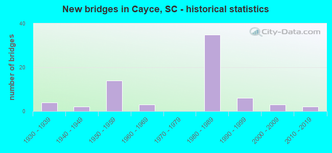
- New bridges - historical statistics
- 41930-1939
- 21940-1949
- 141950-1959
- 31960-1969
- 351980-1989
- 61990-1999
- 32000-2009
- 22010-2019
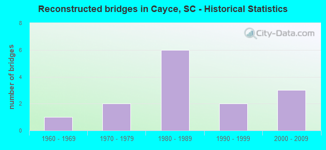
- Reconstructed bridges - Historical Statistics
- 11960-1969
- 21970-1979
- 61980-1989
- 21990-1999
- 32000-2009
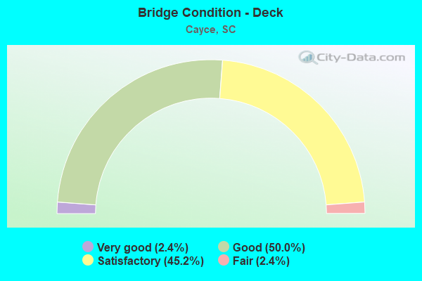
- Bridge Condition - Deck
- 2.4%Very good
- 50.0%Good
- 45.2%Satisfactory
- 2.4%Fair
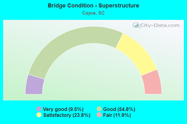
- Bridge Condition - Superstructure
- 9.5%Very good
- 54.8%Good
- 23.8%Satisfactory
- 11.9%Fair
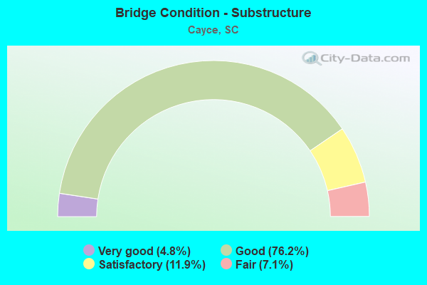
- Bridge Condition - Substructure
- 4.8%Very good
- 76.2%Good
- 11.9%Satisfactory
- 7.1%Fair
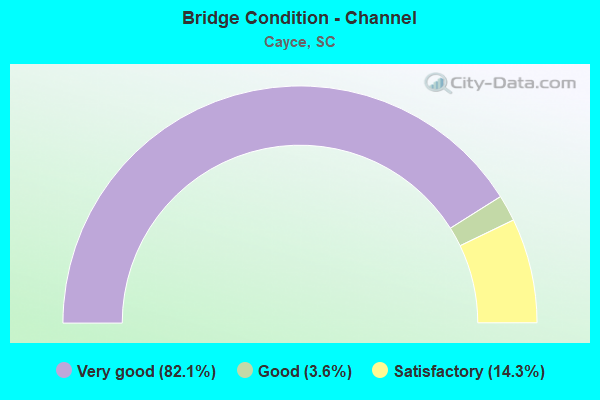
- Bridge Condition - Channel
- 82.1%Very good
- 3.6%Good
- 14.3%Satisfactory
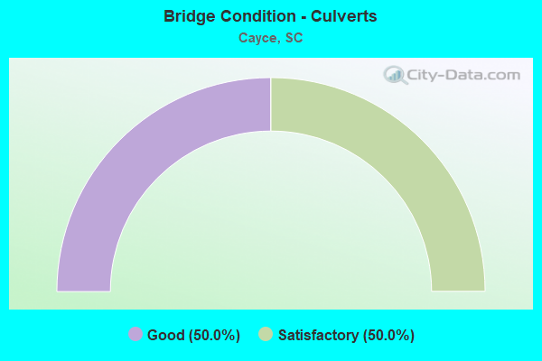
- Bridge Condition - Culverts
- 50.0%Good
- 50.0%Satisfactory
Find on map >> Show street view
Structure Number: 791, Location: 8.2 MI NW OF GREENWOOD (Lat: 34.287628, Lng: -82.246158), Route carried "on" structure: US 178, Year Built: 1937, Status: Posted for load, Structure Length: 5.67m (18.60ft), Average Daily Traffic: 4,200 (year 2020), Truck Traffic: 10%, Average Future Daily Traffic: 7,308 (year 2040), Design Load: H 15, Features Intersected: CSX RR (ABAND)
Minimum Vertical Clearance: 30+ m (98+ ft), Kilometerpoint: 10.715, Lanes on structure: 2, Base Highway Network: Yes, Owner: State Highway Agency, Approaching Roadway Width: 7.9m (25.9ft), Skew: 5 degrees, Material/Design: Steel, Design/Construction: Stringer/Multi-beam, Number Of Spans In Main Unit: 3, Length of Maximum Span: 18.6m (61.0ft), Curb or Sidewalk Widths: Left: 1.2m (3.9ft), Right: 1.2m (3.9ft), Curb-To-Curb Width: 9.2m (30.2ft), Out-to-Out Width: 12.1m (39.7ft)
Condition: Deck: Fair, Superstructure: Fair, Substructure: Fair, Operating Rating: 17.5 metric tons, Method Used To Determine Operating Rating: Load and Resistance Factor Rating (LRFR) rating reported by rating factor(RF) method using HL-93 loadings, Inventory Rating: 13.6 metric tons, Method Used To Determine Inventory Rating: Load and Resistance Factor Rating (LRFR) rating reported by rating factor(RF) method using HL-93 loadings, Structural Evaluation: Meets minimum limits, Deck Geometry: Meets minimum limits, Approach Roadway Alignment: Equal to present minimum criteria, Bridge Posting: Required (Relationship of Operating Rating to Maximum Legal Load: > 39.9% below), Length Of Structure Improvement: 5.67m (18.60ft), Designated Inspection Frequency: Every 24 months, Other Special Inspection Frequency: Every 24 months, Inspection Date: March 2020, Other Special Inspection Date: January 2022, Deck Structure Type: Concrete Cast-file-Place, Wearing Surface/Protective System: Wearing Surface: Bituminous
Find on map >> Show street view
Structure Number: 802, Location: 4 MI SE OF KERSHAW (Lat: 34.512344, Lng: -80.524303), Route carried "on" structure: State highway 341, Year Built: 1937, Year Reconstructed: 1974, Status: Posted for load, Structure Length: 7.62m (25.00ft), Average Daily Traffic: 1,150 (year 2020), Truck Traffic: 10%, Average Future Daily Traffic: 1,829 (year 2040), Design Load: H 15, Features Intersected: LITTLE LYNCHES RIVER (1)
Minimum Vertical Clearance: 30+ m (98+ ft), Kilometerpoint: 0.000, Lanes on structure: 2, Base Highway Network: Yes, Owner: State Highway Agency, Approaching Roadway Width: 12.8m (42.0ft), Material/Design: Steel continuous, Design/Construction: Stringer/Multi-beam, Number Of Spans In Main Unit: 10, Length of Maximum Span: 7.6m (24.9ft), Curb-To-Curb Width: 12.9m (42.3ft), Out-to-Out Width: 14.4m (47.2ft)
Condition: Deck: Good, Superstructure: Fair, Substructure: Fair, Channel: Very good, Operating Rating: 16.5 metric tons, Method Used To Determine Operating Rating: Load and Resistance Factor Rating (LRFR) rating reported by rating factor(RF) method using HL-93 loadings, Inventory Rating: 12.6 metric tons, Method Used To Determine Inventory Rating: Load and Resistance Factor Rating (LRFR) rating reported by rating factor(RF) method using HL-93 loadings, Structural Evaluation: Meets minimum limits, Deck Geometry: Better than present minimum criteria, Waterway Adequacy: Better than present minimum criteria, Approach Roadway Alignment: Equal to present desirable criteria, Bridge Posting: Required (Relationship of Operating Rating to Maximum Legal Load: > 39.9% below), Length Of Structure Improvement: 7.62m (25.00ft), Designated Inspection Frequency: Every 24 months, Other Special Inspection Frequency: Every 24 months, Inspection Date: April 2020, Other Special Inspection Date: December 2021, Deck Structure Type: Concrete Cast-file-Place, Wearing Surface/Protective System: Wearing Surface: Bituminous
Find on map >> Show street view
Structure Number: 884, Location: 2MI NE OF PINERIDGE (Lat: 33.936028, Lng: -81.077053), Route carried "on" structure: US 21, Year Built: 1938, Year Reconstructed: 1985, Status: Open, Structure Length: 0.64m (2.10ft), Average Daily Traffic: 21,200 (year 2021), Truck Traffic: 5%, Average Future Daily Traffic: 33,284 (year 2041), Design Load: H 15, Features Intersected: CONGAREE CREEK
Minimum Vertical Clearance: 30+ m (98+ ft), Kilometerpoint: 26.808, Lanes on structure: 6, Base Highway Network: Yes, Owner: State Highway Agency, Approaching Roadway Width: 30.8m (101.0ft), Material/Design: Concrete, Design/Construction: Culvert, Number Of Spans In Main Unit: 2, Length of Maximum Span: 3.0m (9.8ft), Curb-To-Curb Width: 30.4m (99.7ft), Out-to-Out Width: 40.5m (132.9ft)
Condition: Channel: Satisfactory, Culverts: Good, Operating Rating: 25.9 metric tons, Method Used To Determine Operating Rating: Load and Resistance Factor Rating (LRFR) rating reported by rating factor(RF) method using HL-93 loadings, Inventory Rating: 19.8 metric tons, Method Used To Determine Inventory Rating: Load and Resistance Factor Rating (LRFR) rating reported by rating factor(RF) method using HL-93 loadings, Structural Evaluation: Somewhat better than minimum adequacy, Deck Geometry: Superior to present desirable criteria, Waterway Adequacy: Better than present minimum criteria, Approach Roadway Alignment: Equal to present desirable criteria, Bridge Posting: Required (Relationship of Operating Rating to Maximum Legal Load: > 39.9% below), Length Of Structure Improvement: 1.25m (4.10ft), Designated Inspection Frequency: Every 24 months, Inspection Date: October 2021, Bridge Improvement Cost: $159,000, Roadway Improvement Cost: $40,000, Total Project Cost: $239,000 ( Estimate for 2022)
Find on map >> Show street view
Structure Number: 885, Location: 5 MI SW OF COLUMBIA (Lat: 33.937436, Lng: -81.077606), Route carried "on" structure: US 21, Year Built: 1938, Year Reconstructed: 1985, Status: Posted for load, Structure Length: 2.68m (8.79ft), Average Daily Traffic: 20,400 (year 2020), Truck Traffic: 5%, Average Future Daily Traffic: 32,028 (year 2040), Design Load: HS 15, Features Intersected: CONGAREE CREEK
Minimum Vertical Clearance: 30+ m (98+ ft), Kilometerpoint: 26.948, Lanes on structure: 7, Base Highway Network: Yes, Owner: State Highway Agency, Approaching Roadway Width: 27.4m (89.9ft), Material/Design: Concrete, Design/Construction: Tee Beam, Number Of Spans In Main Unit: 4, Length of Maximum Span: 6.7m (22.0ft), Curb or Sidewalk Widths: Left: 1.5m (4.9ft), Right: 1.5m (4.9ft), Curb-To-Curb Width: 27.4m (89.9ft), Out-to-Out Width: 31.1m (102.0ft)
Condition: Deck: Good, Superstructure: Good, Substructure: Fair, Channel: Satisfactory, Operating Rating: 29.8 metric tons, Method Used To Determine Operating Rating: Load and Resistance Factor Rating (LRFR) rating reported by rating factor(RF) method using HL-93 loadings, Inventory Rating: 20.7 metric tons, Method Used To Determine Inventory Rating: Load and Resistance Factor Rating (LRFR) rating reported by rating factor(RF) method using HL-93 loadings, Structural Evaluation: Somewhat better than minimum adequacy, Deck Geometry: Somewhat better than minimum adequacy, Waterway Adequacy: Equal to present minimum criteria, Approach Roadway Alignment: Equal to present desirable criteria, Bridge Posting: Required (Relationship of Operating Rating to Maximum Legal Load: 20.0 - 29.9% below), Length Of Structure Improvement: 2.68m (8.79ft), Designated Inspection Frequency: Every 24 months, Underwater Inspection Frequency: Every 24 months, Other Special Inspection Frequency: Every 24 months, Inspection Date: October 2021, Underwater Inspection Date: August 2020, Other Special Inspection Date: January 2022, Deck Structure Type: Concrete Cast-file-Place, Wearing Surface/Protective System: Wearing Surface: Bituminous
Find on map >> Show street view
Structure Number: 1095, Location: 1 MI SW OF SPRINGDALE (Lat: 33.954367, Lng: -81.095186), Route carried "on" structure: State highway 302, Year Built: 1940, Year Reconstructed: 2003, Status: Open, Structure Length: 0.98m (3.22ft), Average Daily Traffic: 31,800 (year 2020), Truck Traffic: 19%, Average Future Daily Traffic: 49,926 (year 2040), Design Load: H 20, Features Intersected: SIX MILE CREEK
Minimum Vertical Clearance: 30+ m (98+ ft), Kilometerpoint: 34.807, Lanes on structure: 5, Base Highway Network: Yes, Owner: State Highway Agency, Approaching Roadway Width: 18.9m (62.0ft), Material/Design: Concrete, Design/Construction: Culvert, Number Of Spans In Main Unit: 3, Length of Maximum Span: 3.0m (9.8ft), Curb or Sidewalk Widths: Left: 1.5m (4.9ft), Right: 1.2m (3.9ft), Curb-To-Curb Width: 18.9m (62.0ft), Out-to-Out Width: 22.6m (74.1ft)
Condition: Channel: Very good, Culverts: Satisfactory, Operating Rating: 20.1 metric tons, Method Used To Determine Operating Rating: Load and Resistance Factor Rating (LRFR) rating reported by rating factor(RF) method using HL-93 loadings, Inventory Rating: 15.2 metric tons, Method Used To Determine Inventory Rating: Load and Resistance Factor Rating (LRFR) rating reported by rating factor(RF) method using HL-93 loadings, Structural Evaluation: High priority of corrective action, Deck Geometry: Meets minimum limits, Waterway Adequacy: Superior to present desirable criteria, Approach Roadway Alignment: Equal to present desirable criteria, Bridge Posting: Required (Relationship of Operating Rating to Maximum Legal Load: 30.0 - 39.9% below), Length Of Structure Improvement: 1.62m (5.31ft), Designated Inspection Frequency: Every 24 months, Inspection Date: October 2021, Bridge Improvement Cost: $18,000, Roadway Improvement Cost: $5,000, Total Project Cost: $27,000 ( Estimate for 2021)
Find on map >> Show street view
Structure Number: 1527, Location: 2MI N OF S CONGAREE (Lat: 33.943111, Lng: -81.142556), Route carried "on" structure: State highway 602, Year Built: 1948, Year Reconstructed: 2006, Status: Open, Structure Length: 0.64m (2.10ft), Average Daily Traffic: 11,900 (year 2020), Truck Traffic: 3%, Average Future Daily Traffic: 16,065 (year 2040), Design Load: HS 20, Features Intersected: SAVANA BRANCH
Minimum Vertical Clearance: 30+ m (98+ ft), Kilometerpoint: 9.205, Lanes on structure: 4, Owner: State Highway Agency, Approaching Roadway Width: 20.4m (66.9ft), Material/Design: Concrete, Design/Construction: Culvert, Number Of Spans In Main Unit: 2, Length of Maximum Span: 3.0m (9.8ft), Curb-To-Curb Width: 20.6m (67.6ft), Out-to-Out Width: 34.1m (111.9ft)
Condition: Channel: Very good, Culverts: Good, Operating Rating: 91.4 metric tons, Method Used To Determine Operating Rating: Load and Resistance Factor Rating (LRFR) rating reported by rating factor(RF) method using HL-93 loadings, Inventory Rating: 70.6 metric tons, Method Used To Determine Inventory Rating: Load and Resistance Factor Rating (LRFR) rating reported by rating factor(RF) method using HL-93 loadings, Structural Evaluation: Better than present minimum criteria, Deck Geometry: Superior to present desirable criteria, Waterway Adequacy: Superior to present desirable criteria, Approach Roadway Alignment: Equal to present desirable criteria, Length Of Structure Improvement: 0.64m (2.10ft), Designated Inspection Frequency: Every 24 months, Inspection Date: October 2021
Find on map >> Show street view
Structure Number: 1965, Location: 1 MI SW OF COLUMBIA (Lat: 33.987931, Lng: -81.046831), Route carried "on" structure: US 21, Year Built: 1953, Status: Open, Structure Length: 44.62m (146.39ft), Average Daily Traffic: 24,500 (year 2020), Truck Traffic: 3%, Average Future Daily Traffic: 38,465 (year 2040), Design Load: HS 20, Features Intersected: CONGAREE RIVER
Minimum Vertical Clearance: 30+ m (98+ ft), Kilometerpoint: 34.134, Lanes on structure: 4, Base Highway Network: Yes, Owner: State Highway Agency, Approaching Roadway Width: 16.2m (53.1ft), Skew: 10 degrees, Material/Design: Steel continuous, Design/Construction: Girder and Floorbeam System, Number Of Spans In Main Unit: 13, Length of Maximum Span: 34.7m (113.8ft), Curb or Sidewalk Widths: Left: 1.5m (4.9ft), Right: 1.5m (4.9ft), Curb-To-Curb Width: 16.2m (53.1ft), Out-to-Out Width: 16.6m (54.5ft)
Condition: Deck: Satisfactory, Superstructure: Fair, Substructure: Good, Channel: Very good, Operating Rating: 3.2 metric tons, Method Used To Determine Operating Rating: Load and Resistance Factor Rating (LRFR) rating reported by rating factor(RF) method using HL-93 loadings, Inventory Rating: 2.6 metric tons, Method Used To Determine Inventory Rating: Load and Resistance Factor Rating (LRFR) rating reported by rating factor(RF) method using HL-93 loadings, Structural Evaluation: High priority of replacement, Deck Geometry: Meets minimum limits, Waterway Adequacy: Better than present minimum criteria, Approach Roadway Alignment: Equal to present desirable criteria, Length Of Structure Improvement: 44.71m (146.69ft), Designated Inspection Frequency: Every 24 months, Critical Feature Inspection Frequency: Every 24 months, Underwater Inspection Frequency: Every 60 months, Inspection Date: November 2021, Critical Feature Inspection Date: November 2021, Underwater Inspection Date: October 2017, Bridge Improvement Cost: $6,420,000, Roadway Improvement Cost: $1,605,000, Total Project Cost: $9,630,000 ( Estimate for 2021), Deck Structure Type: Concrete Cast-file-Place, Wearing Surface/Protective System: Wearing Surface: Monolithic Concrete
Find on map >> Show street view
Structure Number: 2213, Location: 5 MI SW OF COLUMBIA (Lat: 33.943528, Lng: -81.078986), Route carried "on" structure: US 21, Year Built: 1955, Year Reconstructed: 1988, Status: Open, Structure Length: 1.01m (3.31ft), Average Daily Traffic: 21,200 (year 2021), Truck Traffic: 5%, Average Future Daily Traffic: 33,284 (year 2041), Design Load: HS 20, Features Intersected: SIX MILE CREEK
Minimum Vertical Clearance: 30+ m (98+ ft), Kilometerpoint: 27.566, Lanes on structure: 4, Base Highway Network: Yes, Owner: State Highway Agency, Approaching Roadway Width: 23.8m (78.1ft), Skew: 22 degrees, Material/Design: Concrete, Design/Construction: Culvert, Number Of Spans In Main Unit: 3, Length of Maximum Span: 3.0m (9.8ft), Curb-To-Curb Width: 23.8m (78.1ft), Out-to-Out Width: 25.6m (84.0ft)
Condition: Channel: Very good, Culverts: Satisfactory, Operating Rating: 25.3 metric tons, Method Used To Determine Operating Rating: Load and Resistance Factor Rating (LRFR) rating reported by rating factor(RF) method using HL-93 loadings, Inventory Rating: 19.4 metric tons, Method Used To Determine Inventory Rating: Load and Resistance Factor Rating (LRFR) rating reported by rating factor(RF) method using HL-93 loadings, Structural Evaluation: Meets minimum limits, Deck Geometry: Superior to present desirable criteria, Waterway Adequacy: Better than present minimum criteria, Approach Roadway Alignment: Equal to present desirable criteria, Length Of Structure Improvement: 1.01m (3.31ft), Designated Inspection Frequency: Every 24 months, Inspection Date: October 2021
Find on map >> Show street view
Structure Number: 2792, Location: 5 MI SW OF COLUMBIA (Lat: 33.946297, Lng: -81.090156), Route carried "on" structure: Interstate 26, Year Built: 1958, Year Reconstructed: 1993, Status: Open, Structure Length: 5.49m (18.01ft), Average Daily Traffic: 80,700 (year 2020), Truck Traffic: 9%, Average Future Daily Traffic: 100,068 (year 2040), Design Load: HS 20+Mod, Features Intersected: RR NS
Minimum Vertical Clearance: 30+ m (98+ ft), Kilometerpoint: 183.015, Lanes on structure: 6, Base Highway Network: Yes, Owner: State Highway Agency, Approaching Roadway Width: 30.9m (101.4ft), Skew: 32 degrees, Material/Design: Concrete, Design/Construction: Tee Beam, Number Of Spans In Main Unit: 3, Length of Maximum Span: 18.3m (60.0ft), Curb-To-Curb Width: 30.9m (101.4ft), Out-to-Out Width: 32.6m (107.0ft)
Condition: Deck: Satisfactory, Superstructure: Satisfactory, Substructure: Good, Operating Rating: 38.9 metric tons, Method Used To Determine Operating Rating: Load and Resistance Factor Rating (LRFR) rating reported by rating factor(RF) method using HL-93 loadings, Inventory Rating: 27.9 metric tons, Method Used To Determine Inventory Rating: Load and Resistance Factor Rating (LRFR) rating reported by rating factor(RF) method using HL-93 loadings, Structural Evaluation: Equal to present minimum criteria, Deck Geometry: Superior to present desirable criteria, Underclear: Equal to present minimum criteria, Approach Roadway Alignment: Equal to present desirable criteria, Length Of Structure Improvement: 5.49m (18.01ft), Designated Inspection Frequency: Every 24 months, Inspection Date: November 2021, Deck Structure Type: Concrete Cast-file-Place, Wearing Surface/Protective System: Wearing Surface: Monolithic Concrete
Find on map >> Show street view
Structure Number: 2793, Location: 3 MI S OF WEST COLUMBIA (Lat: 33.932836, Lng: -81.076839), Route carried "on" structure: Interstate 26, Year Built: 1958, Year Reconstructed: 1983, Status: Open, Structure Length: 9.02m (29.59ft), Average Daily Traffic: 80,700 (year 2020), Truck Traffic: 9%, Average Future Daily Traffic: 100,068 (year 2040), Design Load: HS 20+Mod, Features Intersected: US 21/US 321/ US 176
Minimum Vertical Clearance: 4.78m (15.68ft), Kilometerpoint: 185.023, Lanes on structure: 8, Lanes under structure: 8, Base Highway Network: Yes, Owner: State Highway Agency, Approaching Roadway Width: 41.5m (136.2ft), Skew: 33 degrees, Material/Design: Prestressed concrete, Design/Construction: Stringer/Multi-beam, Number Of Spans In Main Unit: 4, Length of Maximum Span: 22.6m (74.1ft), Curb-To-Curb Width: 40.2m (131.9ft), Out-to-Out Width: 41.8m (137.1ft)
Condition: Deck: Good, Superstructure: Satisfactory, Substructure: Good, Operating Rating: 57.0 metric tons, Method Used To Determine Operating Rating: Load and Resistance Factor Rating (LRFR) rating reported by rating factor(RF) method using HL-93 loadings, Inventory Rating: 22.7 metric tons, Method Used To Determine Inventory Rating: Load and Resistance Factor Rating (LRFR) rating reported by rating factor(RF) method using HL-93 loadings, Structural Evaluation: Somewhat better than minimum adequacy, Deck Geometry: Superior to present desirable criteria, Underclear: Meets minimum limits, Approach Roadway Alignment: Equal to present desirable criteria, Length Of Structure Improvement: 9.02m (29.59ft), Designated Inspection Frequency: Every 24 months, Inspection Date: October 2021, Deck Structure Type: Concrete Cast-file-Place, Wearing Surface/Protective System: Wearing Surface: Bituminous
Find on map >> Show street view
Structure Number: 2801, Location: TOWN OF S CONGAREE (Lat: 33.938617, Lng: -81.086339), Route carried "on" structure: State highway 72, Year Built: 1958, Year Reconstructed: 2014, Status: Open, Structure Length: 6.83m (22.41ft), Average Daily Traffic: 10,200 (year 2020), Truck Traffic: 15%, Average Future Daily Traffic: 16,422 (year 2040), Design Load: HS 15, Features Intersected: I-26
Minimum Vertical Clearance: 30+ m (98+ ft), Kilometerpoint: 0.735, Lanes on structure: 2, Lanes under structure: 6, Owner: State Highway Agency, Approaching Roadway Width: 7.9m (25.9ft), Skew: 1 degrees, Material/Design: Concrete, Design/Construction: Tee Beam, Number Of Spans In Main Unit: 4, Length of Maximum Span: 17.1m (56.1ft), Curb or Sidewalk Widths: Left: 0.5m (1.6ft), Right: 0.5m (1.6ft), Curb-To-Curb Width: 7.9m (25.9ft), Out-to-Out Width: 9.1m (29.9ft)
Condition: Deck: Satisfactory, Superstructure: Satisfactory, Substructure: Good, Operating Rating: 22.7 metric tons, Method Used To Determine Operating Rating: Load and Resistance Factor Rating (LRFR) rating reported by rating factor(RF) method using HL-93 loadings, Inventory Rating: 15.9 metric tons, Method Used To Determine Inventory Rating: Load and Resistance Factor Rating (LRFR) rating reported by rating factor(RF) method using HL-93 loadings, Structural Evaluation: High priority of replacement, Deck Geometry: High priority of corrective action, Underclear: High priority of replacement, Approach Roadway Alignment: Equal to present desirable criteria, Bridge Posting: Required (Relationship of Operating Rating to Maximum Legal Load: 30.0 - 39.9% below), Length Of Structure Improvement: 7.83m (25.69ft), Designated Inspection Frequency: Every 24 months, Inspection Date: November 2020, Bridge Improvement Cost: $991,000, Roadway Improvement Cost: $248,000, Total Project Cost: $1,487,000 ( Estimate for 2021), Deck Structure Type: Concrete Cast-file-Place, Wearing Surface/Protective System: Wearing Surface: Monolithic Concrete
Find on map >> Show street view
Structure Number: 3024, Location: 4 MI SW OF W COLA (Lat: 33.956061, Lng: -81.093353), Route carried "on" structure: Interstate 26, Year Built: 1959, Year Reconstructed: 1993, Status: Open, Structure Length: 6.83m (22.41ft), Average Daily Traffic: 85,300 (year 2020), Truck Traffic: 9%, Average Future Daily Traffic: 105,772 (year 2040), Design Load: HS 20+Mod, Features Intersected: SC 302
Minimum Vertical Clearance: 4.75m (15.58ft), Kilometerpoint: 181.885, Lanes on structure: 6, Lanes under structure: 6, Base Highway Network: Yes, Owner: State Highway Agency, Approaching Roadway Width: 31.1m (102.0ft), Skew: 33 degrees, Material/Design: Concrete, Design/Construction: Tee Beam, Number Of Spans In Main Unit: 4, Length of Maximum Span: 17.1m (56.1ft), Curb-To-Curb Width: 31.7m (104.0ft), Out-to-Out Width: 32.6m (107.0ft)
Condition: Deck: Satisfactory, Superstructure: Fair, Substructure: Satisfactory, Operating Rating: 36.3 metric tons, Method Used To Determine Operating Rating: Load and Resistance Factor Rating (LRFR) rating reported by rating factor(RF) method using HL-93 loadings, Inventory Rating: 26.2 metric tons, Method Used To Determine Inventory Rating: Load and Resistance Factor Rating (LRFR) rating reported by rating factor(RF) method using HL-93 loadings, Structural Evaluation: Somewhat better than minimum adequacy, Deck Geometry: Superior to present desirable criteria, Underclear: Meets minimum limits, Approach Roadway Alignment: Equal to present desirable criteria, Length Of Structure Improvement: 6.83m (22.41ft), Designated Inspection Frequency: Every 24 months, Inspection Date: October 2021, Deck Structure Type: Concrete Cast-file-Place, Wearing Surface/Protective System: Wearing Surface: Monolithic Concrete
Find on map >> Show street view
Structure Number: 3025, Location: 2.5 MI NE OF PINERIDGE (Lat: 33.935006, Lng: -81.080856), Route carried "on" structure: Interstate 26, Year Built: 1959, Year Reconstructed: 1984, Status: Open, Structure Length: 4.88m (16.01ft), Average Daily Traffic: 80,700 (year 2020), Truck Traffic: 9%, Average Future Daily Traffic: 100,068 (year 2040), Design Load: HS 20+Mod, Features Intersected: CONGAREE CREEK
Minimum Vertical Clearance: 30+ m (98+ ft), Kilometerpoint: 184.603, Lanes on structure: 8, Base Highway Network: Yes, Owner: State Highway Agency, Approaching Roadway Width: 45.7m (149.9ft), Skew: 30 degrees, Material/Design: Concrete, Design/Construction: Tee Beam, Number Of Spans In Main Unit: 5, Length of Maximum Span: 9.8m (32.2ft), Curb-To-Curb Width: 44.5m (146.0ft), Out-to-Out Width: 45.7m (149.9ft)
Condition: Deck: Good, Superstructure: Good, Substructure: Good, Channel: Satisfactory, Operating Rating: 40.2 metric tons, Method Used To Determine Operating Rating: Load and Resistance Factor Rating (LRFR) rating reported by rating factor(RF) method using HL-93 loadings, Inventory Rating: 31.1 metric tons, Method Used To Determine Inventory Rating: Load and Resistance Factor Rating (LRFR) rating reported by rating factor(RF) method using HL-93 loadings, Structural Evaluation: Better than present minimum criteria, Deck Geometry: Superior to present desirable criteria, Waterway Adequacy: Equal to present desirable criteria, Approach Roadway Alignment: Equal to present desirable criteria, Length Of Structure Improvement: 4.88m (16.01ft), Designated Inspection Frequency: Every 24 months, Underwater Inspection Frequency: Every 60 months, Inspection Date: November 2021, Underwater Inspection Date: August 2020, Deck Structure Type: Concrete Cast-file-Place, Wearing Surface/Protective System: Wearing Surface: Bituminous
Find on map >> Show street view
Structure Number: 3026, Location: 4 MI S OF CAYCE (Lat: 33.916036, Lng: -81.061669), Route carried "on" structure: Interstate 26, Year Built: 2016, Status: Open, Structure Length: 7.77m (25.49ft), Average Daily Traffic: 60,300 (year 2020), Truck Traffic: 9%, Average Future Daily Traffic: 74,772 (year 2040), Design Load: HL 93, Features Intersected: RR CSXT & S-1798 & S-129
Minimum Vertical Clearance: 30+ m (98+ ft), Kilometerpoint: 187.423, Lanes on structure: 6, Lanes under structure: 4, Base Highway Network: Yes, Owner: State Highway Agency, Approaching Roadway Width: 34.7m (113.8ft), Skew: 31 degrees, Material/Design: Prestressed concrete, Design/Construction: Stringer/Multi-beam, Number Of Spans In Main Unit: 3, Length of Maximum Span: 32.0m (105.0ft), Curb-To-Curb Width: 17.4m (57.1ft), Out-to-Out Width: 34.1m (111.9ft)
Condition: Deck: Good, Superstructure: Very good, Substructure: Good, Operating Rating: 53.8 metric tons, Method Used To Determine Operating Rating: Load and Resistance Factor Rating (LRFR) rating reported by rating factor(RF) method using HL-93 loadings, Inventory Rating: 41.5 metric tons, Method Used To Determine Inventory Rating: Load and Resistance Factor Rating (LRFR) rating reported by rating factor(RF) method using HL-93 loadings, Structural Evaluation: Better than present minimum criteria, Deck Geometry: High priority of replacement, Underclear: High priority of corrective action, Approach Roadway Alignment: Equal to present desirable criteria, Length Of Structure Improvement: 8.81m (28.90ft), Designated Inspection Frequency: Every 24 months, Inspection Date: October 2021, Bridge Improvement Cost: $194,000, Roadway Improvement Cost: $49,000, Total Project Cost: $291,000 ( Estimate for 2021), Deck Structure Type: Concrete Cast-file-Place, Wearing Surface/Protective System: Wearing Surface: Monolithic Concrete
Find on map >> Show street view
Structure Number: 303, Location: 6MI S OF CAYCE (Lat: 33.880553, Lng: -81.036903), Route carried "on" structure: US 21, Year Built: 1959, Year Reconstructed: 1992, Status: Open, Structure Length: 7.19m (23.59ft), Average Daily Traffic: 4,500 (year 2020), Truck Traffic: 15%, Average Future Daily Traffic: 7,065 (year 2040), Design Load: HS 20, Features Intersected: I-26 (NO 2)
Minimum Vertical Clearance: 30+ m (98+ ft), Kilometerpoint: 18.842, Lanes on structure: 2, Lanes under structure: 8, Base Highway Network: Yes, Owner: State Highway Agency, Approaching Roadway Width: 8.5m (27.9ft), Skew: 1 degrees, Material/Design: Prestressed concrete, Design/Construction: Stringer/Multi-beam, Number Of Spans In Main Unit: 4, Length of Maximum Span: 19.8m (65.0ft), Curb-To-Curb Width: 8.5m (27.9ft), Out-to-Out Width: 9.5m (31.2ft)
Condition: Deck: Satisfactory, Superstructure: Satisfactory, Substructure: Good, Operating Rating: 41.1 metric tons, Method Used To Determine Operating Rating: Load and Resistance Factor Rating (LRFR) rating reported by rating factor(RF) method using HL-93 loadings, Inventory Rating: 31.1 metric tons, Method Used To Determine Inventory Rating: Load and Resistance Factor Rating (LRFR) rating reported by rating factor(RF) method using HL-93 loadings, Structural Evaluation: Equal to present minimum criteria, Deck Geometry: Meets minimum limits, Underclear: High priority of corrective action, Approach Roadway Alignment: Better than present minimum criteria, Length Of Structure Improvement: 7.19m (23.59ft), Designated Inspection Frequency: Every 24 months, Inspection Date: October 2021, Deck Structure Type: Concrete Cast-file-Place, Wearing Surface/Protective System: Wearing Surface: Monolithic Concrete
Find on map >> Show street view
Structure Number: 3036, Location: 4 MI SE OF PINE RIDGE (Lat: 33.893325, Lng: -81.043042), Route carried "on" structure: State highway 1258, Year Built: 1959, Year Reconstructed: 2014, Status: Open, Structure Length: 7.99m (26.21ft), Average Daily Traffic: 2,300 (year 2020), Truck Traffic: 7%, Average Future Daily Traffic: 3,703 (year 2040), Design Load: HS 15, Features Intersected: I-26
Minimum Vertical Clearance: 30+ m (98+ ft), Kilometerpoint: 3.283, Lanes on structure: 2, Lanes under structure: 6, Owner: State Highway Agency, Approaching Roadway Width: 7.9m (25.9ft), Material/Design: Concrete, Design/Construction: Tee Beam, Number Of Spans In Main Unit: 5, Length of Maximum Span: 16.5m (54.1ft), Curb or Sidewalk Widths: Left: 0.5m (1.6ft), Right: 0.5m (1.6ft), Curb-To-Curb Width: 7.9m (25.9ft), Out-to-Out Width: 9.1m (29.9ft)
Condition: Deck: Satisfactory, Superstructure: Satisfactory, Substructure: Good, Operating Rating: 33.0 metric tons, Method Used To Determine Operating Rating: Load and Resistance Factor Rating (LRFR) rating reported by rating factor(RF) method using HL-93 loadings, Inventory Rating: 23.7 metric tons, Method Used To Determine Inventory Rating: Load and Resistance Factor Rating (LRFR) rating reported by rating factor(RF) method using HL-93 loadings, Structural Evaluation: Equal to present minimum criteria, Deck Geometry: High priority of corrective action, Underclear: Meets minimum limits, Approach Roadway Alignment: Equal to present desirable criteria, Length Of Structure Improvement: 9.04m (29.66ft), Designated Inspection Frequency: Every 24 months, Inspection Date: November 2020, Bridge Improvement Cost: $411,000, Roadway Improvement Cost: $103,000, Total Project Cost: $617,000 ( Estimate for 2021), Deck Structure Type: Concrete Cast-file-Place, Wearing Surface/Protective System: Wearing Surface: Monolithic Concrete
Find on map >> Show street view
Structure Number: 3376, Location: 2MI SW OF W COLA (Lat: 33.952119, Lng: -81.092058), Route carried "on" structure: Interstate 26, Year Built: 1960, Status: Open, Structure Length: 0.98m (3.22ft), Average Daily Traffic: 82,200 (year 2021), Truck Traffic: 9%, Average Future Daily Traffic: 101,928 (year 2041), Design Load: H 15, Features Intersected: SIX MILE CREEK
Minimum Vertical Clearance: 30+ m (98+ ft), Kilometerpoint: 182.368, Lanes on structure: 6, Base Highway Network: Yes, Owner: State Highway Agency, Approaching Roadway Width: 31.4m (103.0ft), Material/Design: Concrete, Design/Construction: Culvert, Number Of Spans In Main Unit: 3, Length of Maximum Span: 3.0m (9.8ft), Curb-To-Curb Width: 31.7m (104.0ft), Out-to-Out Width: 36.3m (119.1ft)
Condition: Channel: Very good, Culverts: Satisfactory, Operating Rating: 35.3 metric tons, Method Used To Determine Operating Rating: Load and Resistance Factor Rating (LRFR) rating reported by rating factor(RF) method using HL-93 loadings, Inventory Rating: 27.2 metric tons, Method Used To Determine Inventory Rating: Load and Resistance Factor Rating (LRFR) rating reported by rating factor(RF) method using HL-93 loadings, Structural Evaluation: Equal to present minimum criteria, Deck Geometry: Superior to present desirable criteria, Waterway Adequacy: Better than present minimum criteria, Approach Roadway Alignment: Equal to present desirable criteria, Length Of Structure Improvement: 0.98m (3.22ft), Designated Inspection Frequency: Every 24 months, Underwater Inspection Frequency: Every 60 months, Inspection Date: October 2021, Underwater Inspection Date: September 2020
Find on map >> Show street view
Structure Number: 3377, Location: 6 MI S OF CAYCE (Lat: 33.890722, Lng: -81.040972), Route carried "on" structure: Interstate 26, Year Built: 1960, Year Reconstructed: 1990, Status: Open, Structure Length: 0.66m (2.17ft), Average Daily Traffic: 66,700 (year 2021), Truck Traffic: 18%, Average Future Daily Traffic: 82,708 (year 2041), Design Load: HS 20, Features Intersected: TOMS CREEK
Minimum Vertical Clearance: 30+ m (98+ ft), Kilometerpoint: 190.801, Lanes on structure: 6, Base Highway Network: Yes, Owner: State Highway Agency, Approaching Roadway Width: 24.4m (80.1ft), Material/Design: Concrete, Design/Construction: Culvert, Number Of Spans In Main Unit: 2, Length of Maximum Span: 3.0m (9.8ft), Curb-To-Curb Width: 24.4m (80.1ft), Out-to-Out Width: 30.5m (100.1ft)
Condition: Channel: Very good, Culverts: Satisfactory, Operating Rating: 67.7 metric tons, Method Used To Determine Operating Rating: Load and Resistance Factor Rating (LRFR) rating reported by rating factor(RF) method using HL-93 loadings, Inventory Rating: 52.2 metric tons, Method Used To Determine Inventory Rating: Load and Resistance Factor Rating (LRFR) rating reported by rating factor(RF) method using HL-93 loadings, Structural Evaluation: Equal to present minimum criteria, Deck Geometry: Meets minimum limits, Waterway Adequacy: Better than present minimum criteria, Approach Roadway Alignment: Equal to present desirable criteria, Length Of Structure Improvement: 0.66m (2.17ft), Designated Inspection Frequency: Every 24 months, Underwater Inspection Frequency: Every 60 months, Inspection Date: October 2021, Underwater Inspection Date: September 2020
Find on map >> Show street view
Structure Number: 4475, Location: 2 MI NW OF ST MATTHEWS (Lat: 33.854944, Lng: -81.022847), Route carried "on" structure: US 21, Year Built: 1965, Status: Open, Structure Length: 0.64m (2.10ft), Average Daily Traffic: 4,600 (year 2020), Truck Traffic: 9%, Average Future Daily Traffic: 8,924 (year 2040), Design Load: H 20, Features Intersected: SAVANY HUNT CREEK
Minimum Vertical Clearance: 30+ m (98+ ft), Kilometerpoint: 30.695, Lanes on structure: 2, Owner: State Highway Agency, Approaching Roadway Width: 8.6m (28.2ft), Material/Design: Concrete, Design/Construction: Culvert, Number Of Spans In Main Unit: 2, Length of Maximum Span: 3.0m (9.8ft), Curb-To-Curb Width: 12.2m (40.0ft), Out-to-Out Width: 30.2m (99.1ft)
Condition: Channel: Very good, Culverts: Good, Operating Rating: 37.9 metric tons, Method Used To Determine Operating Rating: Load and Resistance Factor Rating (LRFR) rating reported by rating factor(RF) method using HL-93 loadings, Inventory Rating: 29.2 metric tons, Method Used To Determine Inventory Rating: Load and Resistance Factor Rating (LRFR) rating reported by rating factor(RF) method using HL-93 loadings, Structural Evaluation: Better than present minimum criteria, Deck Geometry: Equal to present minimum criteria, Waterway Adequacy: Equal to present minimum criteria, Approach Roadway Alignment: Equal to present desirable criteria, Length Of Structure Improvement: 0.64m (2.10ft), Designated Inspection Frequency: Every 24 months, Inspection Date: July 2020
Find on map >> Show street view
Structure Number: 7729, Location: 4 MI S COLUMBIA (Lat: 33.947306, Lng: -80.997944), Route carried "on" structure: Interstate 77, Year Built: 1983, Status: Open, Structure Length: 14.63m (48.00ft), Average Daily Traffic: 44,000 (year 2020), Truck Traffic: 9%, Average Future Daily Traffic: 54,560 (year 2040), Design Load: HS 20, Features Intersected: TRIB TO GILLS CREEK
Minimum Vertical Clearance: 30+ m (98+ ft), Kilometerpoint: 7.694, Lanes on structure: 3, Base Highway Network: Yes, Owner: State Highway Agency, Approaching Roadway Width: 18.0m (59.1ft), Material/Design: Concrete continuous, Design/Construction: Slab, Number Of Spans In Main Unit: 16, Length of Maximum Span: 9.1m (29.9ft), Curb-To-Curb Width: 17.1m (56.1ft), Out-to-Out Width: 18.1m (59.4ft)
Condition: Deck: Good, Superstructure: Good, Substructure: Good, Channel: Very good, Operating Rating: 48.9 metric tons, Method Used To Determine Operating Rating: Load and Resistance Factor Rating (LRFR) rating reported by rating factor(RF) method using HL-93 loadings, Inventory Rating: 37.6 metric tons, Method Used To Determine Inventory Rating: Load and Resistance Factor Rating (LRFR) rating reported by rating factor(RF) method using HL-93 loadings, Structural Evaluation: Better than present minimum criteria, Deck Geometry: Equal to present minimum criteria, Waterway Adequacy: Equal to present desirable criteria, Approach Roadway Alignment: Equal to present desirable criteria, Length Of Structure Improvement: 14.63m (48.00ft), Designated Inspection Frequency: Every 24 months, Inspection Date: January 2020, Deck Structure Type: Concrete Cast-file-Place, Wearing Surface/Protective System: Wearing Surface: Monolithic Concrete
Find on map >> Show street view
Structure Number: 7731, Location: 4 MI S COLUMBIA (Lat: 33.947475, Lng: -80.998183), Route carried "on" structure: Interstate 77, Year Built: 1983, Status: Open, Structure Length: 14.63m (48.00ft), Average Daily Traffic: 44,000 (year 2020), Truck Traffic: 9%, Average Future Daily Traffic: 54,560 (year 2040), Design Load: HS 20+Mod, Features Intersected: TRIB TO GILLS CREEK
Minimum Vertical Clearance: 30+ m (98+ ft), Kilometerpoint: 7.749, Lanes on structure: 3, Base Highway Network: Yes, Owner: State Highway Agency, Approaching Roadway Width: 17.1m (56.1ft), Material/Design: Concrete continuous, Design/Construction: Slab, Number Of Spans In Main Unit: 16, Length of Maximum Span: 9.1m (29.9ft), Curb-To-Curb Width: 17.1m (56.1ft), Out-to-Out Width: 18.1m (59.4ft)
Condition: Deck: Good, Superstructure: Good, Substructure: Good, Channel: Very good, Operating Rating: 46.3 metric tons, Method Used To Determine Operating Rating: Load and Resistance Factor Rating (LRFR) rating reported by rating factor(RF) method using HL-93 loadings, Inventory Rating: 36.0 metric tons, Method Used To Determine Inventory Rating: Load and Resistance Factor Rating (LRFR) rating reported by rating factor(RF) method using HL-93 loadings, Structural Evaluation: Better than present minimum criteria, Deck Geometry: Equal to present minimum criteria, Waterway Adequacy: Equal to present desirable criteria, Approach Roadway Alignment: Equal to present desirable criteria, Length Of Structure Improvement: 14.63m (48.00ft), Designated Inspection Frequency: Every 24 months, Inspection Date: January 2020, Deck Structure Type: Concrete Cast-file-Place, Wearing Surface/Protective System: Wearing Surface: Monolithic Concrete
Find on map >> Show street view
Structure Number: 7812, Location: 3 MI SE SPRINGDALE (Lat: 33.929525, Lng: -81.050639), Route carried "on" structure: Interstate 77, Year Built: 1984, Status: Open, Structure Length: 23.77m (77.99ft), Average Daily Traffic: 43,750 (year 2020), Truck Traffic: 9%, Average Future Daily Traffic: 54,250 (year 2040), Design Load: HS 20+Mod, Features Intersected: CONGAREE RIVER OVF #3
Minimum Vertical Clearance: 30+ m (98+ ft), Kilometerpoint: 1.991, Lanes on structure: 3, Base Highway Network: Yes, Owner: State Highway Agency, Approaching Roadway Width: 20.1m (65.9ft), Material/Design: Concrete continuous, Design/Construction: Slab, Number Of Spans In Main Unit: 26, Length of Maximum Span: 9.1m (29.9ft), Curb-To-Curb Width: 20.7m (67.9ft), Out-to-Out Width: 21.8m (71.5ft)
Condition: Deck: Satisfactory, Superstructure: Good, Substructure: Good, Channel: Very good, Operating Rating: 84.6 metric tons, Method Used To Determine Operating Rating: Load and Resistance Factor Rating (LRFR) rating reported by rating factor(RF) method using HL-93 loadings, Inventory Rating: 65.4 metric tons, Method Used To Determine Inventory Rating: Load and Resistance Factor Rating (LRFR) rating reported by rating factor(RF) method using HL-93 loadings, Structural Evaluation: Better than present minimum criteria, Deck Geometry: Superior to present desirable criteria, Waterway Adequacy: Superior to present desirable criteria, Approach Roadway Alignment: Equal to present desirable criteria, Length Of Structure Improvement: 23.77m (77.99ft), Designated Inspection Frequency: Every 24 months, Inspection Date: November 2021, Deck Structure Type: Concrete Cast-file-Place, Wearing Surface/Protective System: Wearing Surface: Monolithic Concrete
Find on map >> Show street view
Structure Number: 7813, Location: 3 MI SE SPRINGDALE (Lat: 33.929853, Lng: -81.050633), Route carried "on" structure: Interstate 77, Year Built: 1984, Status: Open, Structure Length: 23.77m (77.99ft), Average Daily Traffic: 43,750 (year 2020), Truck Traffic: 9%, Average Future Daily Traffic: 54,250 (year 2040), Design Load: HS 20+Mod, Features Intersected: CONGAREE RIVER OFV #3
Minimum Vertical Clearance: 30+ m (98+ ft), Kilometerpoint: 2.071, Lanes on structure: 3, Base Highway Network: Yes, Owner: State Highway Agency, Approaching Roadway Width: 20.7m (67.9ft), Material/Design: Concrete continuous, Design/Construction: Slab, Number Of Spans In Main Unit: 26, Length of Maximum Span: 9.1m (29.9ft), Curb-To-Curb Width: 20.7m (67.9ft), Out-to-Out Width: 21.8m (71.5ft)
Condition: Deck: Satisfactory, Superstructure: Good, Substructure: Satisfactory, Channel: Very good, Operating Rating: 84.6 metric tons, Method Used To Determine Operating Rating: Load and Resistance Factor Rating (LRFR) rating reported by rating factor(RF) method using HL-93 loadings, Inventory Rating: 65.4 metric tons, Method Used To Determine Inventory Rating: Load and Resistance Factor Rating (LRFR) rating reported by rating factor(RF) method using HL-93 loadings, Structural Evaluation: Equal to present minimum criteria, Deck Geometry: Superior to present desirable criteria, Waterway Adequacy: Superior to present desirable criteria, Approach Roadway Alignment: Equal to present desirable criteria, Length Of Structure Improvement: 23.77m (77.99ft), Designated Inspection Frequency: Every 24 months, Inspection Date: November 2021, Deck Structure Type: Concrete Cast-file-Place, Wearing Surface/Protective System: Wearing Surface: Monolithic Concrete
Find on map >> Show street view
Structure Number: 7825, Location: 5 MI S COLUMBIA (Lat: 33.935031, Lng: -81.011042), Route carried "on" structure: Interstate 77, Year Built: 1984, Status: Open, Structure Length: 4.57m (14.99ft), Average Daily Traffic: 46,200 (year 2021), Truck Traffic: 15%, Average Future Daily Traffic: 57,288 (year 2041), Design Load: HS 20+Mod, Features Intersected: S-40-537
Minimum Vertical Clearance: 4.88m (16.01ft), Kilometerpoint: 5.787, Lanes on structure: 3, Lanes under structure: 2, Base Highway Network: Yes, Owner: State Highway Agency, Approaching Roadway Width: 17.1m (56.1ft), Material/Design: Steel, Design/Construction: Stringer/Multi-beam, Number Of Spans In Main Unit: 3, Length of Maximum Span: 15.2m (49.9ft), Curb-To-Curb Width: 17.1m (56.1ft), Out-to-Out Width: 18.1m (59.4ft)
Condition: Deck: Satisfactory, Superstructure: Good, Substructure: Good, Operating Rating: 66.7 metric tons, Method Used To Determine Operating Rating: Load and Resistance Factor Rating (LRFR) rating reported by rating factor(RF) method using HL-93 loadings, Inventory Rating: 51.2 metric tons, Method Used To Determine Inventory Rating: Load and Resistance Factor Rating (LRFR) rating reported by rating factor(RF) method using HL-93 loadings, Structural Evaluation: Better than present minimum criteria, Deck Geometry: Equal to present minimum criteria, Underclear: Better than present minimum criteria, Approach Roadway Alignment: Equal to present desirable criteria, Length Of Structure Improvement: 4.57m (14.99ft), Designated Inspection Frequency: Every 24 months, Inspection Date: December 2021, Deck Structure Type: Concrete Cast-file-Place, Wearing Surface/Protective System: Wearing Surface: Monolithic Concrete
Find on map >> Show street view
Structure Number: 7826, Location: 5 MI S OF COLUMBIA (Lat: 33.940714, Lng: -81.004097), Route carried "on" structure: Interstate 77, Year Built: 1984, Status: Open, Structure Length: 40.23m (131.99ft), Average Daily Traffic: 46,200 (year 2021), Truck Traffic: 15%, Average Future Daily Traffic: 57,288 (year 2041), Design Load: HS 20+Mod, Features Intersected: CONGAREE SWAMP
Minimum Vertical Clearance: 30+ m (98+ ft), Kilometerpoint: 6.577, Lanes on structure: 3, Base Highway Network: Yes, Owner: State Highway Agency, Approaching Roadway Width: 17.7m (58.1ft), Material/Design: Concrete continuous, Design/Construction: Slab, Number Of Spans In Main Unit: 44, Length of Maximum Span: 9.1m (29.9ft), Curb-To-Curb Width: 17.1m (56.1ft), Out-to-Out Width: 18.1m (59.4ft)
Condition: Deck: Good, Superstructure: Good, Substructure: Good, Channel: Very good, Operating Rating: 48.6 metric tons, Method Used To Determine Operating Rating: Load and Resistance Factor Rating (LRFR) rating reported by rating factor(RF) method using HL-93 loadings, Inventory Rating: 37.6 metric tons, Method Used To Determine Inventory Rating: Load and Resistance Factor Rating (LRFR) rating reported by rating factor(RF) method using HL-93 loadings, Structural Evaluation: Better than present minimum criteria, Deck Geometry: Equal to present minimum criteria, Waterway Adequacy: Equal to present desirable criteria, Approach Roadway Alignment: Equal to present desirable criteria, Length Of Structure Improvement: 40.23m (131.99ft), Designated Inspection Frequency: Every 24 months, Inspection Date: December 2021, Deck Structure Type: Concrete Cast-file-Place, Wearing Surface/Protective System: Wearing Surface: Monolithic Concrete
Find on map >> Show street view
Structure Number: 783, Location: 5 MI S COLUMBIA (Lat: 33.935272, Lng: -81.011175), Route carried "on" structure: Interstate 77, Year Built: 1984, Status: Open, Structure Length: 4.57m (14.99ft), Average Daily Traffic: 46,200 (year 2021), Truck Traffic: 15%, Average Future Daily Traffic: 57,288 (year 2041), Design Load: HS 20+Mod, Features Intersected: S-40-537
Minimum Vertical Clearance: 4.44m (14.57ft), Kilometerpoint: 5.807, Lanes on structure: 3, Lanes under structure: 2, Base Highway Network: Yes, Owner: State Highway Agency, Approaching Roadway Width: 17.1m (56.1ft), Material/Design: Steel, Design/Construction: Stringer/Multi-beam, Number Of Spans In Main Unit: 3, Length of Maximum Span: 15.2m (49.9ft), Curb-To-Curb Width: 17.1m (56.1ft), Out-to-Out Width: 18.1m (59.4ft)
Condition: Deck: Good, Superstructure: Good, Substructure: Good, Operating Rating: 54.4 metric tons, Method Used To Determine Operating Rating: Load and Resistance Factor Rating (LRFR) rating reported by rating factor(RF) method using HL-93 loadings, Inventory Rating: 41.8 metric tons, Method Used To Determine Inventory Rating: Load and Resistance Factor Rating (LRFR) rating reported by rating factor(RF) method using HL-93 loadings, Structural Evaluation: Better than present minimum criteria, Deck Geometry: Equal to present minimum criteria, Underclear: Equal to present minimum criteria, Approach Roadway Alignment: Equal to present desirable criteria, Length Of Structure Improvement: 4.57m (14.99ft), Designated Inspection Frequency: Every 24 months, Inspection Date: December 2021, Deck Structure Type: Concrete Cast-file-Place, Wearing Surface/Protective System: Wearing Surface: Monolithic Concrete
Find on map >> Show street view
Structure Number: 7831, Location: 5 MI S OF COLUMBIA (Lat: 33.940883, Lng: -81.004333), Route carried "on" structure: Interstate 77, Year Built: 1984, Status: Open, Structure Length: 40.23m (131.99ft), Average Daily Traffic: 46,200 (year 2021), Truck Traffic: 15%, Average Future Daily Traffic: 57,288 (year 2041), Design Load: HS 20+Mod, Features Intersected: CONGAREE SWAMP
Minimum Vertical Clearance: 30+ m (98+ ft), Kilometerpoint: 6.606, Lanes on structure: 3, Base Highway Network: Yes, Owner: State Highway Agency, Approaching Roadway Width: 17.1m (56.1ft), Material/Design: Concrete continuous, Design/Construction: Slab, Number Of Spans In Main Unit: 44, Length of Maximum Span: 9.1m (29.9ft), Curb-To-Curb Width: 17.1m (56.1ft), Out-to-Out Width: 18.1m (59.4ft)
Condition: Deck: Good, Superstructure: Good, Substructure: Good, Channel: Very good, Operating Rating: 48.6 metric tons, Method Used To Determine Operating Rating: Load and Resistance Factor Rating (LRFR) rating reported by rating factor(RF) method using HL-93 loadings, Inventory Rating: 37.6 metric tons, Method Used To Determine Inventory Rating: Load and Resistance Factor Rating (LRFR) rating reported by rating factor(RF) method using HL-93 loadings, Structural Evaluation: Better than present minimum criteria, Deck Geometry: Equal to present minimum criteria, Waterway Adequacy: Superior to present desirable criteria, Approach Roadway Alignment: Equal to present desirable criteria, Length Of Structure Improvement: 40.23m (131.99ft), Designated Inspection Frequency: Every 24 months, Inspection Date: December 2021, Deck Structure Type: Concrete Cast-file-Place, Wearing Surface/Protective System: Wearing Surface: Monolithic Concrete
Find on map >> Show street view
Structure Number: 7909, Location: 4 MI S OF W COLUMBIA (Lat: 33.933181, Lng: -81.076725), Route carried "on" structure: Ramp Interstate 26, Year Built: 1985, Status: Open, Structure Length: 9.02m (29.59ft), Average Daily Traffic: 6,000 (year 2017), Average Future Daily Traffic: 13,980 (year 2037), Design Load: HS 20+Mod, Features Intersected: US 21 AND US 321
Minimum Vertical Clearance: 30+ m (98+ ft), Kilometerpoint: 184.114, Lanes on structure: 1, Lanes under structure: 8, Owner: State Highway Agency, Approaching Roadway Width: 7.9m (25.9ft), Skew: 3 degrees, Material/Design: Steel, Design/Construction: Stringer/Multi-beam, Number Of Spans In Main Unit: 4, Length of Maximum Span: 25.6m (84.0ft), Curb-To-Curb Width: 7.9m (25.9ft), Out-to-Out Width: 9.0m (29.5ft)
Condition: Deck: Good, Superstructure: Good, Substructure: Good, Operating Rating: 65.1 metric tons, Method Used To Determine Operating Rating: Load and Resistance Factor Rating (LRFR) rating reported by rating factor(RF) method using HL-93 loadings, Inventory Rating: 50.2 metric tons, Method Used To Determine Inventory Rating: Load and Resistance Factor Rating (LRFR) rating reported by rating factor(RF) method using HL-93 loadings, Structural Evaluation: Better than present minimum criteria, Deck Geometry: Equal to present desirable criteria, Underclear: Meets minimum limits, Approach Roadway Alignment: Equal to present desirable criteria, Length Of Structure Improvement: 9.02m (29.59ft), Designated Inspection Frequency: Every 24 months, Inspection Date: October 2021, Deck Structure Type: Concrete Cast-file-Place, Wearing Surface/Protective System: Wearing Surface: Monolithic Concrete
Find on map >> Show street view
Structure Number: 791, Location: 3 MI S OF CAYCE (Lat: 33.928897, Lng: -81.056469), Route carried "on" structure: Interstate 77, Year Built: 1985, Status: Open, Structure Length: 7.86m (25.79ft), Average Daily Traffic: 43,750 (year 2020), Truck Traffic: 9%, Average Future Daily Traffic: 54,250 (year 2040), Design Load: HS 20+Mod, Features Intersected: S-129 & RR CSXT
Minimum Vertical Clearance: 30+ m (98+ ft), Kilometerpoint: 1.526, Lanes on structure: 4, Lanes under structure: 2, Base Highway Network: Yes, Owner: State Highway Agency, Approaching Roadway Width: 20.7m (67.9ft), Skew: 2 degrees, Material/Design: Steel continuous, Design/Construction: Stringer/Multi-beam, Number Of Spans In Main Unit: 2, Number Of Approach Spans: 2, Length of Maximum Span: 21.9m (71.9ft), Curb-To-Curb Width: 20.7m (67.9ft), Out-to-Out Width: 21.8m (71.5ft)
Condition: Deck: Satisfactory, Superstructure: Good, Substructure: Good, Operating Rating: 35.6 metric tons, Method Used To Determine Operating Rating: Load and Resistance Factor Rating (LRFR) rating reported by rating factor(RF) method using HL-93 loadings, Inventory Rating: 27.2 metric tons, Method Used To Determine Inventory Rating: Load and Resistance Factor Rating (LRFR) rating reported by rating factor(RF) method using HL-93 loadings, Structural Evaluation: Equal to present minimum criteria, Deck Geometry: Equal to present minimum criteria, Underclear: Better than present minimum criteria, Approach Roadway Alignment: Equal to present desirable criteria, Length Of Structure Improvement: 7.89m (25.89ft), Designated Inspection Frequency: Every 24 months, Inspection Date: November 2021, Deck Structure Type: Concrete Cast-file-Place, Wearing Surface/Protective System: Wearing Surface: Monolithic Concrete
Find on map >> Show street view
Structure Number: 7911, Location: 3 MI SE SPRINGDALE (Lat: 33.928475, Lng: -81.033972), Route carried "on" structure: Interstate 77, Year Built: 1985, Status: Open, Structure Length: 45.72m (150.00ft), Average Daily Traffic: 44,000 (year 2020), Truck Traffic: 9%, Average Future Daily Traffic: 54,560 (year 2040), Design Load: HS 20+Mod, Features Intersected: L-66
Minimum Vertical Clearance: 30+ m (98+ ft), Kilometerpoint: 3.404, Lanes on structure: 3, Lanes under structure: 2, Base Highway Network: Yes, Owner: State Highway Agency, Approaching Roadway Width: 17.1m (56.1ft), Material/Design: Prestressed concrete, Design/Construction: Stringer/Multi-beam, Number Of Spans In Main Unit: 1, Number Of Approach Spans: 48, Length of Maximum Span: 18.3m (60.0ft), Curb-To-Curb Width: 17.1m (56.1ft), Out-to-Out Width: 18.1m (59.4ft)
Condition: Deck: Satisfactory, Superstructure: Satisfactory, Substructure: Good, Channel: Very good, Operating Rating: 44.1 metric tons, Method Used To Determine Operating Rating: Load and Resistance Factor Rating (LRFR) rating reported by rating factor(RF) method using HL-93 loadings, Inventory Rating: 34.0 metric tons, Method Used To Determine Inventory Rating: Load and Resistance Factor Rating (LRFR) rating reported by rating factor(RF) method using HL-93 loadings, Structural Evaluation: Equal to present minimum criteria, Deck Geometry: Equal to present minimum criteria, Underclear: High priority of corrective action, Waterway Adequacy: Equal to present desirable criteria, Approach Roadway Alignment: Equal to present desirable criteria, Length Of Structure Improvement: 45.72m (150.00ft), Designated Inspection Frequency: Every 24 months, Inspection Date: November 2021, Deck Structure Type: Concrete Cast-file-Place, Wearing Surface/Protective System: Wearing Surface: Monolithic Concrete
Find on map >> Show street view
Structure Number: 7912, Location: 4 MI S OF COLUMBIA (Lat: 33.928261, Lng: -81.027203), Route carried "on" structure: Interstate 77, Year Built: 1985, Status: Open, Structure Length: 43.89m (144.00ft), Average Daily Traffic: 44,000 (year 2020), Truck Traffic: 9%, Average Future Daily Traffic: 54,560 (year 2040), Design Load: HS 20+Mod, Features Intersected: CONGAREE CREEK
Minimum Vertical Clearance: 30+ m (98+ ft), Kilometerpoint: 3.973, Lanes on structure: 3, Base Highway Network: Yes, Owner: State Highway Agency, Approaching Roadway Width: 17.1m (56.1ft), Material/Design: Steel, Design/Construction: Stringer/Multi-beam, Number Of Spans In Main Unit: 1, Number Of Approach Spans: 45, Length of Maximum Span: 27.4m (89.9ft), Curb-To-Curb Width: 17.1m (56.1ft), Out-to-Out Width: 18.1m (59.4ft)
Condition: Deck: Satisfactory, Superstructure: Good, Substructure: Good, Channel: Very good, Operating Rating: 43.1 metric tons, Method Used To Determine Operating Rating: Load and Resistance Factor Rating (LRFR) rating reported by rating factor(RF) method using HL-93 loadings, Inventory Rating: 33.0 metric tons, Method Used To Determine Inventory Rating: Load and Resistance Factor Rating (LRFR) rating reported by rating factor(RF) method using HL-93 loadings, Structural Evaluation: Better than present minimum criteria, Deck Geometry: Equal to present minimum criteria, Waterway Adequacy: Superior to present desirable criteria, Approach Roadway Alignment: Equal to present desirable criteria, Length Of Structure Improvement: 43.89m (144.00ft), Designated Inspection Frequency: Every 24 months, Inspection Date: November 2021, Deck Structure Type: Concrete Cast-file-Place, Wearing Surface/Protective System: Wearing Surface: Monolithic Concrete
Find on map >> Show street view
Structure Number: 7913, Location: 5 MI S COLUMBIA (Lat: 33.932128, Lng: -81.017519), Route carried "on" structure: Interstate 77, Year Built: 1985, Status: Open, Structure Length: 39.87m (130.81ft), Average Daily Traffic: 44,000 (year 2020), Truck Traffic: 9%, Average Future Daily Traffic: 54,560 (year 2040), Design Load: HS 20+Mod, Features Intersected: CONGAREE RIVER
Minimum Vertical Clearance: 30+ m (98+ ft), Kilometerpoint: 4.884, Lanes on structure: 3, Base Highway Network: Yes, Owner: State Highway Agency, Approaching Roadway Width: 16.5m (54.1ft), Material/Design: Steel continuous, Design/Construction: Stringer/Multi-beam, Number Of Spans In Main Unit: 5, Number Of Approach Spans: 6, Length of Maximum Span: 54.9m (180.1ft), Curb-To-Curb Width: 17.1m (56.1ft), Out-to-Out Width: 18.1m (59.4ft)
Condition: Deck: Satisfactory, Superstructure: Satisfactory, Substructure: Satisfactory, Channel: Very good, Operating Rating: 45.0 metric tons, Method Used To Determine Operating Rating: Load and Resistance Factor Rating (LRFR) rating reported by rating factor(RF) method using HL-93 loadings, Inventory Rating: 34.7 metric tons, Method Used To Determine Inventory Rating: Load and Resistance Factor Rating (LRFR) rating reported by rating factor(RF) method using HL-93 loadings, Structural Evaluation: Equal to present minimum criteria, Deck Geometry: Equal to present minimum criteria, Waterway Adequacy: Superior to present desirable criteria, Approach Roadway Alignment: Equal to present desirable criteria, Length Of Structure Improvement: 39.81m (130.61ft), Designated Inspection Frequency: Every 24 months, Inspection Date: November 2021, Deck Structure Type: Concrete Cast-file-Place, Wearing Surface/Protective System: Wearing Surface: Monolithic Concrete
Find on map >> Show street view
Structure Number: 7914, Location: 3 MI S OF CAYCE (Lat: 33.929892, Lng: -81.056189), Route carried "on" structure: Interstate 77, Year Built: 1985, Status: Open, Structure Length: 7.25m (23.79ft), Average Daily Traffic: 43,750 (year 2020), Truck Traffic: 9%, Average Future Daily Traffic: 54,250 (year 2040), Design Load: HS 20+Mod, Features Intersected: S-129 & RR CSXT
Minimum Vertical Clearance: 30+ m (98+ ft), Kilometerpoint: 1.640, Lanes on structure: 4, Lanes under structure: 2, Base Highway Network: Yes, Owner: State Highway Agency, Approaching Roadway Width: 20.7m (67.9ft), Skew: 1 degrees, Material/Design: Steel continuous, Design/Construction: Stringer/Multi-beam, Number Of Spans In Main Unit: 2, Number Of Approach Spans: 2, Length of Maximum Span: 21.9m (71.9ft), Curb-To-Curb Width: 20.7m (67.9ft), Out-to-Out Width: 21.8m (71.5ft)
Condition: Deck: Satisfactory, Superstructure: Good, Substructure: Good, Operating Rating: 35.6 metric tons, Method Used To Determine Operating Rating: Load and Resistance Factor Rating (LRFR) rating reported by rating factor(RF) method using HL-93 loadings, Inventory Rating: 27.5 metric tons, Method Used To Determine Inventory Rating: Load and Resistance Factor Rating (LRFR) rating reported by rating factor(RF) method using HL-93 loadings, Structural Evaluation: Equal to present minimum criteria, Deck Geometry: Equal to present minimum criteria, Underclear: Better than present minimum criteria, Approach Roadway Alignment: Equal to present desirable criteria, Length Of Structure Improvement: 7.28m (23.88ft), Designated Inspection Frequency: Every 24 months, Inspection Date: November 2021, Deck Structure Type: Concrete Cast-file-Place, Wearing Surface/Protective System: Wearing Surface: Monolithic Concrete
Find on map >> Show street view
Structure Number: 7915, Location: 4 MI SE SPRINGDALE (Lat: 33.928747, Lng: -81.033972), Route carried "on" structure: Interstate 77, Year Built: 1985, Status: Open, Structure Length: 45.72m (150.00ft), Average Daily Traffic: 46,200 (year 2021), Truck Traffic: 15%, Average Future Daily Traffic: 57,288 (year 2041), Design Load: HS 20+Mod, Features Intersected: L-66 & OVERFLOW #2
Minimum Vertical Clearance: 7.62m (25.00ft), Kilometerpoint: 3.430, Lanes on structure: 3, Lanes under structure: 2, Base Highway Network: Yes, Owner: State Highway Agency, Approaching Roadway Width: 17.1m (56.1ft), Material/Design: Prestressed concrete, Design/Construction: Stringer/Multi-beam, Number Of Spans In Main Unit: 1, Number Of Approach Spans: 48, Length of Maximum Span: 18.3m (60.0ft), Curb-To-Curb Width: 17.1m (56.1ft), Out-to-Out Width: 18.1m (59.4ft)
Condition: Deck: Satisfactory, Superstructure: Satisfactory, Substructure: Good, Channel: Very good, Operating Rating: 45.4 metric tons, Method Used To Determine Operating Rating: Load and Resistance Factor Rating (LRFR) rating reported by rating factor(RF) method using HL-93 loadings, Inventory Rating: 35.0 metric tons, Method Used To Determine Inventory Rating: Load and Resistance Factor Rating (LRFR) rating reported by rating factor(RF) method using HL-93 loadings, Structural Evaluation: Equal to present minimum criteria, Deck Geometry: Equal to present minimum criteria, Underclear: High priority of corrective action, Waterway Adequacy: Equal to present desirable criteria, Approach Roadway Alignment: Equal to present desirable criteria, Length Of Structure Improvement: 45.72m (150.00ft), Designated Inspection Frequency: Every 24 months, Inspection Date: November 2021, Deck Structure Type: Concrete Cast-file-Place, Wearing Surface/Protective System: Wearing Surface: Monolithic Concrete
Find on map >> Show street view
Structure Number: 7916, Location: 4 MI S OF COLUMBIA (Lat: 33.928528, Lng: -81.027136), Route carried "on" structure: Interstate 77, Year Built: 1985, Status: Open, Structure Length: 43.89m (144.00ft), Average Daily Traffic: 44,000 (year 2020), Truck Traffic: 9%, Average Future Daily Traffic: 54,560 (year 2040), Design Load: HS 20+Mod, Features Intersected: CONGAREE CREEK
Minimum Vertical Clearance: 30+ m (98+ ft), Kilometerpoint: 4.001, Lanes on structure: 3, Base Highway Network: Yes, Owner: State Highway Agency, Approaching Roadway Width: 17.1m (56.1ft), Material/Design: Steel, Design/Construction: Stringer/Multi-beam, Number Of Spans In Main Unit: 1, Number Of Approach Spans: 45, Length of Maximum Span: 27.4m (89.9ft), Curb-To-Curb Width: 17.1m (56.1ft), Out-to-Out Width: 18.1m (59.4ft)
Condition: Deck: Satisfactory, Superstructure: Good, Substructure: Good, Channel: Very good, Operating Rating: 43.1 metric tons, Method Used To Determine Operating Rating: Load and Resistance Factor Rating (LRFR) rating reported by rating factor(RF) method using HL-93 loadings, Inventory Rating: 33.0 metric tons, Method Used To Determine Inventory Rating: Load and Resistance Factor Rating (LRFR) rating reported by rating factor(RF) method using HL-93 loadings, Structural Evaluation: Better than present minimum criteria, Deck Geometry: Equal to present minimum criteria, Waterway Adequacy: Superior to present desirable criteria, Approach Roadway Alignment: Equal to present desirable criteria, Length Of Structure Improvement: 43.89m (144.00ft), Designated Inspection Frequency: Every 24 months, Inspection Date: November 2021, Deck Structure Type: Concrete Cast-file-Place, Wearing Surface/Protective System: Wearing Surface: Monolithic Concrete
Find on map >> Show street view
Structure Number: 7917, Location: 5 MI S COLUMBIA (Lat: 33.932356, Lng: -81.017667), Route carried "on" structure: Interstate 77, Year Built: 1985, Status: Open, Structure Length: 39.87m (130.81ft), Average Daily Traffic: 44,000 (year 2020), Truck Traffic: 9%, Average Future Daily Traffic: 54,560 (year 2040), Design Load: HS 20+Mod, Features Intersected: CONGAREE RIVER
Minimum Vertical Clearance: 30+ m (98+ ft), Kilometerpoint: 4.883, Lanes on structure: 3, Base Highway Network: Yes, Owner: State Highway Agency, Approaching Roadway Width: 16.5m (54.1ft), Material/Design: Steel continuous, Design/Construction: Stringer/Multi-beam, Number Of Spans In Main Unit: 5, Number Of Approach Spans: 6, Length of Maximum Span: 54.9m (180.1ft), Curb-To-Curb Width: 17.1m (56.1ft), Out-to-Out Width: 18.1m (59.4ft)
Condition: Deck: Satisfactory, Superstructure: Satisfactory, Substructure: Satisfactory, Channel: Very good, Operating Rating: 45.4 metric tons, Method Used To Determine Operating Rating: Load and Resistance Factor Rating (LRFR) rating reported by rating factor(RF) method using HL-93 loadings, Inventory Rating: 35.0 metric tons, Method Used To Determine Inventory Rating: Load and Resistance Factor Rating (LRFR) rating reported by rating factor(RF) method using HL-93 loadings, Structural Evaluation: Equal to present minimum criteria, Deck Geometry: Equal to present minimum criteria, Waterway Adequacy: Superior to present desirable criteria, Approach Roadway Alignment: Equal to present desirable criteria, Length Of Structure Improvement: 39.81m (130.61ft), Designated Inspection Frequency: Every 24 months, Inspection Date: November 2021, Deck Structure Type: Concrete Cast-file-Place, Wearing Surface/Protective System: Wearing Surface: Monolithic Concrete
Find on map >> Show street view
Structure Number: 8018, Location: 0.10 MI N OF I-26 (Lat: 33.927747, Lng: -81.069214), Route carried "on" structure: Ramp Interstate 77, Year Built: 1986, Status: Open, Structure Length: 12.31m (40.39ft), Average Daily Traffic: 17,300 (year 2021), Truck Traffic: 9%, Average Future Daily Traffic: 40,309 (year 2041), Design Load: HS 20+Mod, Features Intersected: I-26 WB&RAMP OFF I-26 WB, Facility Carried by Structure: RAMP OFF I-26 EB
Minimum Vertical Clearance: 30+ m (98+ ft), Kilometerpoint: 0.000, Lanes on structure: 1, Lanes under structure: 3, Owner: State Highway Agency, Approaching Roadway Width: 12.5m (41.0ft), Material/Design: Steel continuous, Design/Construction: Stringer/Multi-beam, Number Of Spans In Main Unit: 4, Length of Maximum Span: 40.2m (131.9ft), Curb-To-Curb Width: 12.7m (41.7ft), Out-to-Out Width: 13.2m (43.3ft)
Condition: Deck: Satisfactory, Superstructure: Good, Substructure: Good, Operating Rating: 34.3 metric tons, Method Used To Determine Operating Rating: Load and Resistance Factor Rating (LRFR) rating reported by rating factor(RF) method using HL-93 loadings, Inventory Rating: 26.6 metric tons, Method Used To Determine Inventory Rating: Load and Resistance Factor Rating (LRFR) rating reported by rating factor(RF) method using HL-93 loadings, Structural Evaluation: Equal to present minimum criteria, Deck Geometry: Superior to present desirable criteria, Underclear: Meets minimum limits, Approach Roadway Alignment: Equal to present desirable criteria, Length Of Structure Improvement: 12.31m (40.39ft), Designated Inspection Frequency: Every 24 months, Inspection Date: December 2021, Deck Structure Type: Concrete Cast-file-Place, Wearing Surface/Protective System: Wearing Surface: Monolithic Concrete