Bridge Statistics for Cedar City, Utah (UT)
Condition, Traffic, Stress, Structural Evaluation, Project Costs
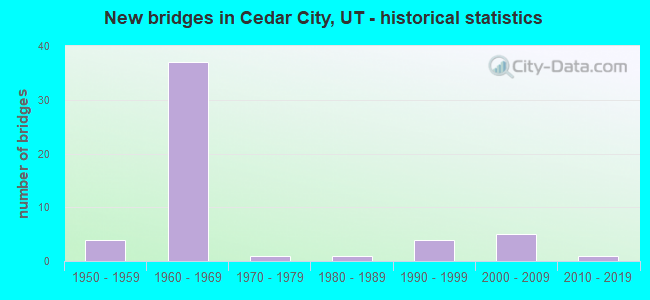
- New bridges - historical statistics
- 41950-1959
- 371960-1969
- 11970-1979
- 11980-1989
- 41990-1999
- 52000-2009
- 12010-2019
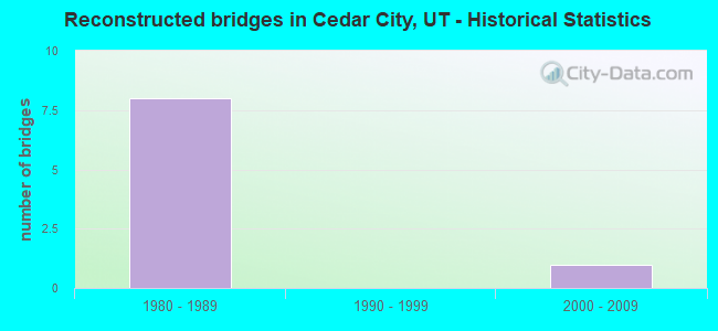
- Reconstructed bridges - Historical Statistics
- 81980-1989
- 01990-1999
- 12000-2009
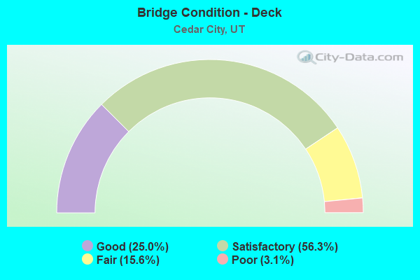
- Bridge Condition - Deck
- 25.0%Good
- 56.3%Satisfactory
- 15.6%Fair
- 3.1%Poor
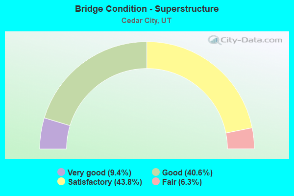
- Bridge Condition - Superstructure
- 9.4%Very good
- 40.6%Good
- 43.8%Satisfactory
- 6.3%Fair
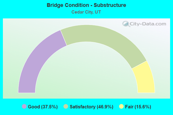
- Bridge Condition - Substructure
- 37.5%Good
- 46.9%Satisfactory
- 15.6%Fair
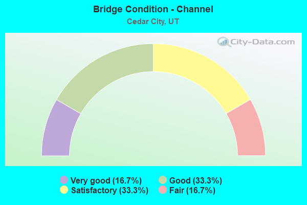
- Bridge Condition - Channel
- 16.7%Very good
- 33.3%Good
- 33.3%Satisfactory
- 16.7%Fair
Find on map >> Show street view
Structure Number: 1F 119, Location: CEDAR CITY INTERCHANGE (Lat: 37.680522, Lng: -113.079692), Route carried "under" structure: State highway 56, Year Built: 1968, Structure Length: 0. m, Average Daily Traffic: 11,521 (year 2020), Truck Traffic: 42%, Features Intersected: SR-56,200 NORTH STREET, Facility Carried by Structure: I-15 (SR-15) NBL
Minimum Vertical Clearance: 5.11m (16.77ft), Kilometerpoint: 97.151, Lanes on structure: 3, Lanes under structure: 5, Material/Design: Prestressed concrete, Design/Construction: Stringer/Multi-beam, Length of Maximum Span: 24.2m (79.4ft)
Find on map >> Show street view
Structure Number: 1F 181, Location: SOUTH CEDAR CITY INTCHG. (Lat: 37.654314, Lng: -113.082253), Route carried "under" structure: City street , Year Built: 1967, Structure Length: 0. m, Features Intersected: CITY ST. & INT. X-RO, Facility Carried by Structure: I-15 (SR-15) NBL
Minimum Vertical Clearance: 5.10m (16.73ft), Kilometerpoint: 0.000, Lanes on structure: 2, Lanes under structure: 4, Material/Design: Prestressed concrete, Design/Construction: Stringer/Multi-beam, Length of Maximum Span: 25.4m (83.3ft)
Find on map >> Show street view
Structure Number: 3C 502, Location: SO CEDAR CITY INTERCHANGE (Lat: 37.651389, Lng: -113.083611), Route carried "under" structure: Interstate 15, Year Built: 1967, Structure Length: 0. m, Average Daily Traffic: 29,862 (year 2020), Truck Traffic: 34%, Features Intersected: I-15 (SR-15) NBL & S, Facility Carried by Structure: SR-130 SBL ONLY
Minimum Vertical Clearance: 4.91m (16.11ft), Kilometerpoint: 91.390, Lanes on structure: 1, Lanes under structure: 4, Material/Design: Steel continuous, Design/Construction: Stringer/Multi-beam, Length of Maximum Span: 27.7m (90.9ft)
Find on map >> Show street view
Structure Number: 3D 753, Location: NO.KANARRAVILLE INTCHG. (Lat: 37.602761, Lng: -113.161467), Route carried "under" structure: County highway 1752, Year Built: 1966, Structure Length: 0. m, Average Daily Traffic: 475 (year 2020), Features Intersected: CO RD TO KANARRAVILLE, Facility Carried by Structure: I-15 (SR-15) SBL
Minimum Vertical Clearance: 4.73m (15.52ft), Kilometerpoint: 0.000, Lanes on structure: 2, Lanes under structure: 2, Material/Design: Concrete continuous, Design/Construction: Tee Beam, Length of Maximum Span: 12.3m (40.4ft)
Find on map >> Show street view
Structure Number: 3D 762, Location: NORTH of CEDAR CITY (Lat: 37.721925, Lng: -113.058922), Route carried "under" structure: City street 1781, Year Built: 1965, Structure Length: 0. m, Features Intersected: NICHOLS CANYON ROAD, Facility Carried by Structure: I-15 (SR-15) SBL
Minimum Vertical Clearance: 5.64m (18.50ft), Kilometerpoint: 0.000, Lanes on structure: 2, Lanes under structure: 2, Material/Design: Concrete continuous, Design/Construction: Tee Beam, Length of Maximum Span: 16.3m (53.5ft)
Find on map >> Show street view
Structure Number: 3D 788, Location: 2.2 MI NO CEDAR CITY INT. (Lat: 37.712017, Lng: -113.068031), Route carried "under" structure: County highway , Year Built: 1968, Structure Length: 0. m, Features Intersected: CITY ST. TO NO. FIELDS, Facility Carried by Structure: I-15 (SR-15) SBL
Minimum Vertical Clearance: 4.31m (14.14ft), Kilometerpoint: 0.000, Lanes on structure: 2, Lanes under structure: 2, Material/Design: Concrete continuous, Design/Construction: Slab, Length of Maximum Span: 10.5m (34.4ft)
Find on map >> Show street view
Structure Number: 3F 117, Location: 0.7 MI.N.CEDAR CITY INT. (Lat: 37.687111, Lng: -113.079297), Route carried "under" structure: City street , Year Built: 1968, Structure Length: 0. m, Features Intersected: 560 N., Facility Carried by Structure: I-15 (SR-15) SBL
Minimum Vertical Clearance: 7.57m (24.84ft), Kilometerpoint: 0.000, Lanes on structure: 2, Lanes under structure: 2, Material/Design: Prestressed concrete, Design/Construction: Stringer/Multi-beam, Length of Maximum Span: 23.4m (76.8ft)
Find on map >> Show street view
Structure Number: 3F 119, Location: CEDAR CITY INTERCHANGE (Lat: 37.681142, Lng: -113.079911), Route carried "under" structure: State highway 56, Year Built: 1968, Structure Length: 0. m, Average Daily Traffic: 11,521 (year 2020), Truck Traffic: 42%, Features Intersected: SR-56,200 NORTH STREET, Facility Carried by Structure: I-15 (SR-15) SBL
Minimum Vertical Clearance: 5.36m (17.59ft), Kilometerpoint: 97.185, Lanes on structure: 3, Lanes under structure: 4, Material/Design: Prestressed concrete, Design/Construction: Stringer/Multi-beam, Length of Maximum Span: 24.2m (79.4ft)
Find on map >> Show street view
Structure Number: 3F 181, Location: SO.CEDAR CITY INTCHG. (Lat: 37.654672, Lng: -113.082433), Route carried "under" structure: City street , Year Built: 1967, Structure Length: 0. m, Features Intersected: CITY ST. , INT. X-ROAD., Facility Carried by Structure: I-15 (SR-15) SBL
Minimum Vertical Clearance: 5.15m (16.90ft), Kilometerpoint: 0.000, Lanes on structure: 2, Lanes under structure: 4, Material/Design: Prestressed concrete, Design/Construction: Stringer/Multi-beam, Length of Maximum Span: 25.4m (83.3ft)