Bridge Statistics for Cedar Hill, Texas (TX)
Condition, Traffic, Stress, Structural Evaluation, Project Costs
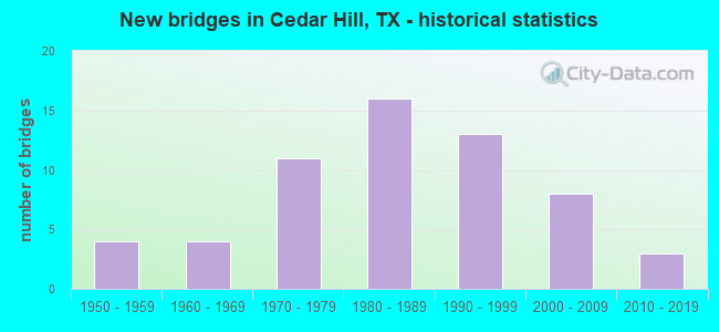
- New bridges - historical statistics
- 41950-1959
- 41960-1969
- 111970-1979
- 161980-1989
- 131990-1999
- 82000-2009
- 32010-2019
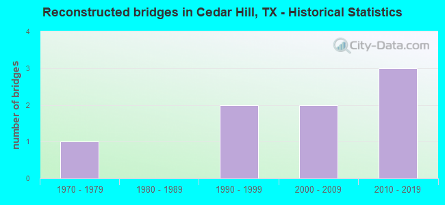
- Reconstructed bridges - Historical Statistics
- 11970-1979
- 01980-1989
- 21990-1999
- 22000-2009
- 32010-2019
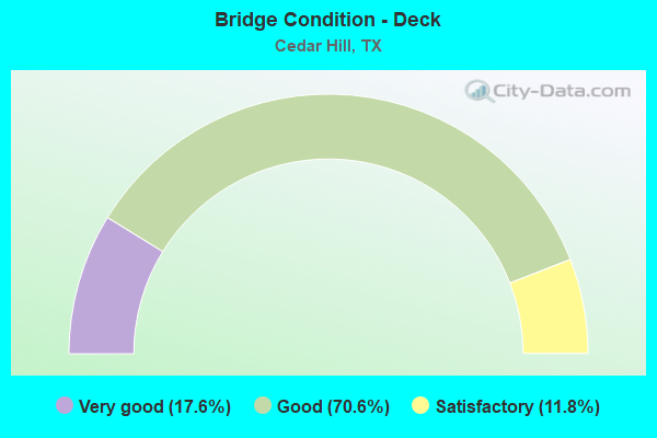
- Bridge Condition - Deck
- 17.6%Very good
- 70.6%Good
- 11.8%Satisfactory
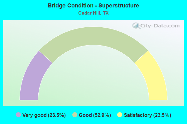
- Bridge Condition - Superstructure
- 23.5%Very good
- 52.9%Good
- 23.5%Satisfactory
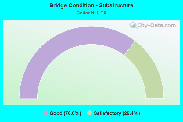
- Bridge Condition - Substructure
- 70.6%Good
- 29.4%Satisfactory
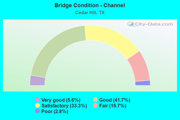
- Bridge Condition - Channel
- 5.6%Very good
- 41.7%Good
- 33.3%Satisfactory
- 16.7%Fair
- 2.8%Poor
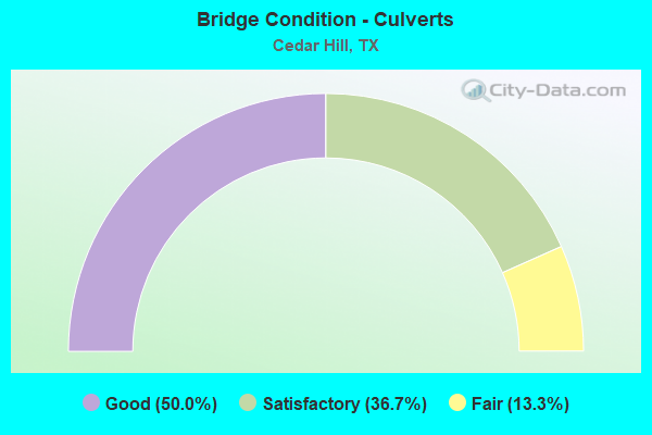
- Bridge Condition - Culverts
- 50.0%Good
- 36.7%Satisfactory
- 13.3%Fair
Find on map >> Show street view
Structure Number: 180570S00630001, Location: 0.5 MI S OF MANSFIELD (Lat: 32.581808, Lng: -96.992103), Route carried "on" structure: City street , Year Built: 1986, Status: Open, Structure Length: 1.62m (5.31ft), Average Daily Traffic: 600 (year 2011), Average Future Daily Traffic: 1,000 (year 2031), Features Intersected: BAGGETT BRANCH, Facility Carried by Structure: LAKEVIEW DR
Minimum Vertical Clearance: 30+ m (98+ ft), Kilometerpoint: 3.380, Lanes on structure: 4, Owner: City or Municipal Highway Agency, Approaching Roadway Width: 13.4m (44.0ft), Material/Design: Concrete, Design/Construction: Culvert, Number Of Spans In Main Unit: 5, Length of Maximum Span: 3.0m (9.8ft)
Condition: Channel: Fair, Culverts: Satisfactory, Operating Rating: 32.7 metric tons, Method Used To Determine Operating Rating: Field evaluation and documented engineering judgment, Inventory Rating: 24.5 metric tons, Method Used To Determine Inventory Rating: Field evaluation and documented engineering judgment, Structural Evaluation: Equal to present minimum criteria, Waterway Adequacy: Better than present minimum criteria, Approach Roadway Alignment: Better than present minimum criteria, Designated Inspection Frequency: Every 24 months, Inspection Date: May 2021
Find on map >> Show street view
Structure Number: 180570S00670001, Location: 0.5 MI SW of Lake Ridge (Lat: 32.550028, Lng: -97.003319), Route carried "on" structure: City street , Year Built: 2003, Status: Open, Structure Length: 1.65m (5.41ft), Average Daily Traffic: 2,317 (year 2019), Truck Traffic: 3%, Average Future Daily Traffic: 3,244 (year 2039), Features Intersected: HOLLINGS BRANCH, Facility Carried by Structure: PRAIRIE VIEW BLVD
Minimum Vertical Clearance: 30+ m (98+ ft), Kilometerpoint: 0.805, Lanes on structure: 4, Owner: City or Municipal Highway Agency, Approaching Roadway Width: 12.2m (40.0ft), Skew: 20 degrees, Material/Design: Concrete, Design/Construction: Culvert, Number Of Spans In Main Unit: 5, Length of Maximum Span: 3.0m (9.8ft), Curb or Sidewalk Widths: Left: 1.8m (5.9ft), Right: 1.7m (5.6ft), Curb-To-Curb Width: 14.1m (46.3ft), Out-to-Out Width: 24.1m (79.1ft)
Condition: Channel: Good, Culverts: Satisfactory, Operating Rating: 32.7 metric tons, Method Used To Determine Operating Rating: Field evaluation and documented engineering judgment, Inventory Rating: 24.5 metric tons, Method Used To Determine Inventory Rating: Field evaluation and documented engineering judgment, Structural Evaluation: Equal to present minimum criteria, Deck Geometry: High priority of replacement, Waterway Adequacy: Better than present minimum criteria, Approach Roadway Alignment: Equal to present desirable criteria, Designated Inspection Frequency: Every 24 months, Inspection Date: Febuary 2021, Deck Structure Type: Concrete Cast-file-Place, Wearing Surface/Protective System: Wearing Surface: Monolithic Concrete
Find on map >> Show street view
Structure Number: 180570T02185001, Location: 1.6 MI W of US 67 (Lat: 32.557483, Lng: -96.998506), Route carried "on" structure: City street , Year Built: 2012, Status: Open, Structure Length: 1.52m (4.99ft), Average Daily Traffic: 2,991 (year 2019), Truck Traffic: 3%, Average Future Daily Traffic: 4,187 (year 2039), Features Intersected: TRIB HOLLINGS BRANCH, Facility Carried by Structure: LAKE RIDGE PKWY
Minimum Vertical Clearance: 30+ m (98+ ft), Kilometerpoint: 2.575, Lanes on structure: 4, Owner: City or Municipal Highway Agency, Approaching Roadway Width: 13.4m (44.0ft), Skew: 23 degrees, Material/Design: Concrete, Design/Construction: Culvert, Number Of Spans In Main Unit: 4, Length of Maximum Span: 3.0m (9.8ft), Curb or Sidewalk Widths: Left: 4.0m (13.1ft), Right: 1.5m (4.9ft), Curb-To-Curb Width: 13.4m (44.0ft), Out-to-Out Width: 36.6m (120.1ft)
Condition: Channel: Good, Culverts: Good, Operating Rating: 32.7 metric tons, Method Used To Determine Operating Rating: Field evaluation and documented engineering judgment, Inventory Rating: 24.5 metric tons, Method Used To Determine Inventory Rating: Field evaluation and documented engineering judgment, Structural Evaluation: Equal to present minimum criteria, Deck Geometry: High priority of replacement, Waterway Adequacy: Better than present minimum criteria, Approach Roadway Alignment: Equal to present desirable criteria, Designated Inspection Frequency: Every 24 months, Inspection Date: Febuary 2021, Deck Structure Type: Concrete Cast-file-Place, Wearing Surface/Protective System: Wearing Surface: Monolithic Concrete
Find on map >> Show street view
Structure Number: 180570026102058, Location: 5.5 MI SW OF IH 20 (Lat: 32.596144, Lng: -96.940161), Route carried "under" structure: US 67, Year Built: 1979, Structure Length: 0. m, Average Daily Traffic: 51,620 (year 2013), Truck Traffic: 9%, Features Intersected: US 67, Facility Carried by Structure: FM 1382
Minimum Vertical Clearance: 5.92m (19.42ft), Kilometerpoint: 23.010, Lanes on structure: 6, Lanes under structure: 6, Material/Design: Prestressed concrete, Design/Construction: Stringer/Multi-beam, Length of Maximum Span: 38.4m (126.0ft)
Find on map >> Show street view
Structure Number: 180570026102059, Location: 6.45 MI SW OF IH 20 (Lat: 32.585875, Lng: -96.950369), Route carried "under" structure: Alternate City street , Year Built: 1979, Structure Length: 0. m, Average Daily Traffic: 997 (year 2016), Features Intersected: COOPER ST, Facility Carried by Structure: US 67 SBML
Minimum Vertical Clearance: 5.13m (16.83ft), Kilometerpoint: 39.801, Lanes on structure: 2, Lanes under structure: 6, Material/Design: Prestressed concrete, Design/Construction: Stringer/Multi-beam, Length of Maximum Span: 22.9m (75.1ft)
Find on map >> Show street view
Structure Number: 18057002610206, Location: 6.45 MI SW OF IH 20 (Lat: 32.585189, Lng: -96.950519), Route carried "under" structure: Alternate City street , Year Built: 1979, Structure Length: 0. m, Average Daily Traffic: 997 (year 2016), Features Intersected: COOPER ST, Facility Carried by Structure: US 67 NBML
Minimum Vertical Clearance: 4.98m (16.34ft), Kilometerpoint: 39.801, Lanes on structure: 2, Lanes under structure: 6, Material/Design: Prestressed concrete, Design/Construction: Stringer/Multi-beam, Length of Maximum Span: 22.9m (75.1ft)
Find on map >> Show street view
Structure Number: 180570026102061, Location: 6.1 MI SW OF IH 20 (Lat: 32.590003, Lng: -96.946519), Route carried "under" structure: US 67, Year Built: 1979, Structure Length: 0. m, Average Daily Traffic: 32,560 (year 2013), Truck Traffic: 9%, Features Intersected: US 67, Facility Carried by Structure: BELT LINE RD
Minimum Vertical Clearance: 5.44m (17.85ft), Kilometerpoint: 24.565, Lanes on structure: 4, Lanes under structure: 6, Material/Design: Prestressed concrete, Design/Construction: Stringer/Multi-beam, Length of Maximum Span: 39.9m (130.9ft)
Find on map >> Show street view
Structure Number: 180570026102064, Location: 4.7 MI SW OF IH 20 (Lat: 32.604528, Lng: -96.931581), Route carried "under" structure: US 67, Year Built: 1983, Structure Length: 0. m, Average Daily Traffic: 51,620 (year 2013), Truck Traffic: 9%, Features Intersected: US 67, Facility Carried by Structure: PLEASANT RUN RD
Minimum Vertical Clearance: 5.92m (19.42ft), Kilometerpoint: 22.613, Lanes on structure: 4, Material/Design: Prestressed concrete, Design/Construction: Stringer/Multi-beam, Length of Maximum Span: 39.6m (129.9ft)
Find on map >> Show street view
Structure Number: 180570026102065, Location: 4.25 MI SW OF IH 20 (Lat: 32.609414, Lng: -96.925750), Route carried "under" structure: City street , Year Built: 1983, Structure Length: 0. m, Average Daily Traffic: 700 (year 2016), Features Intersected: JOE WILSON RD, Facility Carried by Structure: US 67 NBML
Minimum Vertical Clearance: 5.23m (17.16ft), Kilometerpoint: 9.012, Lanes on structure: 6, Material/Design: Prestressed concrete, Design/Construction: Stringer/Multi-beam, Length of Maximum Span: 21.6m (70.9ft)
Find on map >> Show street view
Structure Number: 180570026102066, Location: 4.25 MI SW OF IH 20 (Lat: 32.610628, Lng: -96.924944), Route carried "under" structure: City street , Year Built: 1983, Structure Length: 0. m, Average Daily Traffic: 700 (year 2016), Features Intersected: JOE WILSON RD, Facility Carried by Structure: US 67 SBML
Minimum Vertical Clearance: 5.16m (16.93ft), Kilometerpoint: 9.012, Lanes on structure: 6, Material/Design: Prestressed concrete, Design/Construction: Stringer/Multi-beam, Length of Maximum Span: 21.6m (70.9ft)
Find on map >> Show street view
Structure Number: 180570026102068, Location: 3.40 MI SW OF IH 20 (Lat: 32.618478, Lng: -96.915111), Route carried "under" structure: City street , Year Built: 1983, Structure Length: 0. m, Average Daily Traffic: 280 (year 2016), Features Intersected: WINTERGREEN RD, Facility Carried by Structure: US 67 NBML
Minimum Vertical Clearance: 5.21m (17.09ft), Kilometerpoint: 3.460, Lanes on structure: 6, Material/Design: Prestressed concrete, Design/Construction: Stringer/Multi-beam, Length of Maximum Span: 40.2m (131.9ft)
Find on map >> Show street view
Structure Number: 180570026102079, Location: 8.5 MI SW OF IH 20 (Lat: 32.562022, Lng: -96.969892), Route carried "under" structure: Alternate City street , Year Built: 1991, Structure Length: 0. m, Average Daily Traffic: 700 (year 2016), Features Intersected: MT LEBANON RD, Facility Carried by Structure: US 67 SBML
Minimum Vertical Clearance: 5.18m (16.99ft), Kilometerpoint: 16.855, Lanes on structure: 2, Lanes under structure: 4, Material/Design: Prestressed concrete, Design/Construction: Stringer/Multi-beam, Length of Maximum Span: 25.9m (85.0ft)
Find on map >> Show street view
Structure Number: 18057002610208, Location: 8.5 MI SW OF IH 20 (Lat: 32.561378, Lng: -96.969806), Route carried "under" structure: Alternate City street , Year Built: 1991, Structure Length: 0. m, Average Daily Traffic: 700 (year 2016), Features Intersected: MT LEBANON RD, Facility Carried by Structure: US 67 NBML
Minimum Vertical Clearance: 6.65m (21.82ft), Kilometerpoint: 16.855, Lanes on structure: 2, Lanes under structure: 4, Material/Design: Prestressed concrete, Design/Construction: Stringer/Multi-beam, Length of Maximum Span: 25.9m (85.0ft)
Find on map >> Show street view
Structure Number: 180570026102082, Location: 7.1 MI SW OF IH 20 (Lat: 32.578686, Lng: -96.957636), Route carried "under" structure: US 67, Year Built: 1991, Structure Length: 0. m, Average Daily Traffic: 41,650 (year 2013), Truck Traffic: 8%, Features Intersected: US 67, Facility Carried by Structure: TIDWELL ST
Minimum Vertical Clearance: 5.28m (17.32ft), Kilometerpoint: 26.379, Lanes on structure: 2, Lanes under structure: 4, Material/Design: Prestressed concrete, Design/Construction: Stringer/Multi-beam, Length of Maximum Span: 24.4m (80.1ft)
Find on map >> Show street view
Structure Number: 180570104702019, Location: 0.60 Mi NW of US 67 (Lat: 32.602094, Lng: -96.946606), Route carried "under" structure: City street , Year Built: 1995, Structure Length: 0. m, Average Daily Traffic: 1,000 (year 2016), Truck Traffic: 5%, Features Intersected: BNSF RR/Cedar Hill /Draw, Facility Carried by Structure: FM 1382
Minimum Vertical Clearance: 9.14m (29.99ft), Kilometerpoint: 1.609, Lanes on structure: 6, Lanes under structure: 3, Material/Design: Prestressed concrete, Design/Construction: Stringer/Multi-beam, Length of Maximum Span: 25.3m (83.0ft)