Bridge Statistics for Cedar Rapids, Iowa (IA)
Condition, Traffic, Stress, Structural Evaluation, Project Costs
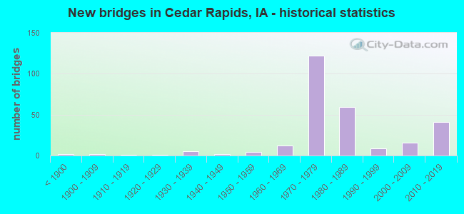
- New bridges - historical statistics
- 2Before 1900
- 21900-1909
- 11910-1919
- 11920-1929
- 51930-1939
- 21940-1949
- 41950-1959
- 121960-1969
- 1221970-1979
- 591980-1989
- 91990-1999
- 162000-2009
- 412010-2019
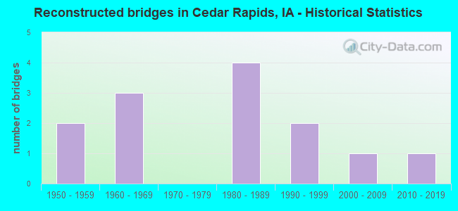
- Reconstructed bridges - Historical Statistics
- 21950-1959
- 31960-1969
- 01970-1979
- 41980-1989
- 21990-1999
- 12000-2009
- 12010-2019
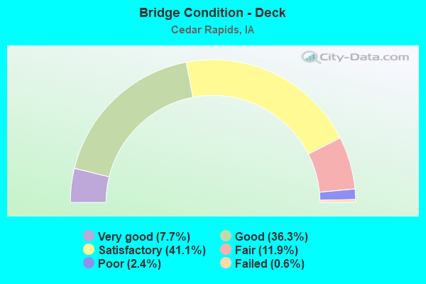
- Bridge Condition - Deck
- 7.7%Very good
- 36.3%Good
- 41.1%Satisfactory
- 11.9%Fair
- 2.4%Poor
- 0.6%Failed
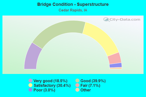
- Bridge Condition - Superstructure
- 18.5%Very good
- 39.9%Good
- 30.4%Satisfactory
- 7.1%Fair
- 3.0%Poor
- 1.2%Serious
- 0.6%Failed
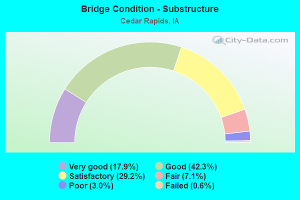
- Bridge Condition - Substructure
- 17.9%Very good
- 42.3%Good
- 29.2%Satisfactory
- 7.1%Fair
- 3.0%Poor
- 0.6%Failed
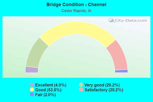
- Bridge Condition - Channel
- 4.0%Excellent
- 20.2%Very good
- 53.5%Good
- 20.2%Satisfactory
- 2.0%Fair
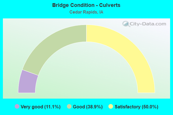
- Bridge Condition - Culverts
- 11.1%Very good
- 38.9%Good
- 50.0%Satisfactory
Find on map >> Show street view
Structure Number: 60396, Location: 3.9 mi. N of Jct. US 30 (Lat: 41.980558, Lng: -91.668994), Route carried "under" structure: City street , Year Built: 1979, Structure Length: 0. m, Average Daily Traffic: 300 (year 1979), Features Intersected: 2ND ST NE, Facility Carried by Structure: I 380 SB OFF RAMP
Minimum Vertical Clearance: 30+ m (98+ ft), Kilometerpoint: 0.188, Lanes on structure: 1, Lanes under structure: 4, Material/Design: Steel continuous, Design/Construction: Stringer/Multi-beam, Length of Maximum Span: 20.4m (66.9ft)
Find on map >> Show street view
Structure Number: 60397, Location: 0.6 MI.N.OF JCT. US 151 (Lat: 41.979494, Lng: -91.670492), Route carried "under" structure: City street , Year Built: 1979, Structure Length: 0. m, Average Daily Traffic: 4,374 (year 1979), Features Intersected: 2ND ST NE, Facility Carried by Structure: I 380 NB ON RAMP
Minimum Vertical Clearance: 30+ m (98+ ft), Kilometerpoint: 0.143, Lanes on structure: 1, Lanes under structure: 4, Material/Design: Steel continuous, Design/Construction: Stringer/Multi-beam, Length of Maximum Span: 20.1m (65.9ft)
Find on map >> Show street view
Structure Number: 60411, Location: AT JCT. 30 (Lat: 41.944881, Lng: -91.741514), Route carried "under" structure: US 30, Year Built: 1980, Structure Length: 0. m, Average Daily Traffic: 4,200 (year 2020), Truck Traffic: 25%, Features Intersected: US 30 W JCT, Facility Carried by Structure: NB US 151/922
Minimum Vertical Clearance: 30+ m (98+ ft), Kilometerpoint: 396.087, Lanes on structure: 2, Lanes under structure: 4, Material/Design: Steel continuous, Design/Construction: Stringer/Multi-beam, Length of Maximum Span: 35.4m (116.1ft)
Find on map >> Show street view
Structure Number: 60412, Location: AT JCT. U.S. 30 (Lat: 41.945547, Lng: -91.740478), Route carried "under" structure: US 30, Year Built: 1980, Structure Length: 0. m, Average Daily Traffic: 4,200 (year 2020), Truck Traffic: 25%, Features Intersected: US 30 W JCT, Facility Carried by Structure: SB US 151/922
Minimum Vertical Clearance: 30+ m (98+ ft), Kilometerpoint: 396.055, Lanes on structure: 2, Lanes under structure: 4, Material/Design: Steel continuous, Design/Construction: Stringer/Multi-beam, Length of Maximum Span: 35.4m (116.1ft)
Find on map >> Show street view
Structure Number: 60413, Location: 2.6 MI. W OF JCT. I-380 (Lat: 41.938125, Lng: -91.715867), Route carried "under" structure: US 30, Year Built: 1980, Structure Length: 0. m, Average Daily Traffic: 20,000 (year 2020), Truck Traffic: 14%, Features Intersected: US 30, Facility Carried by Structure: EDGEWOOD RD
Minimum Vertical Clearance: 30+ m (98+ ft), Kilometerpoint: 398.298, Lanes on structure: 4, Lanes under structure: 5, Material/Design: Prestressed concrete, Design/Construction: Stringer/Multi-beam, Length of Maximum Span: 29.6m (97.1ft)
Find on map >> Show street view
Structure Number: 60414, Location: 1.9 MI. W OF JCT. 218 (Lat: 41.935819, Lng: -91.705967), Route carried "under" structure: City street , Year Built: 1980, Structure Length: 0. m, Average Daily Traffic: 130 (year 1993), Features Intersected: UP RR, 21ST ST SW, CREEK, Facility Carried by Structure: US 30 EB
Minimum Vertical Clearance: 30+ m (98+ ft), Kilometerpoint: 3.365, Lanes on structure: 2, Lanes under structure: 2, Material/Design: Steel continuous, Design/Construction: Stringer/Multi-beam, Length of Maximum Span: 41.8m (137.1ft)
Find on map >> Show street view
Structure Number: 60415, Location: 1.6 MI.W.OF E.JCT.218 (Lat: 41.935175, Lng: -91.702400), Route carried "under" structure: City street , Year Built: 1980, Structure Length: 0. m, Average Daily Traffic: 130 (year 1993), Features Intersected: UP RR, 21ST ST SW, CREEK, Facility Carried by Structure: US 30 WB
Minimum Vertical Clearance: 30+ m (98+ ft), Kilometerpoint: 3.402, Lanes on structure: 2, Lanes under structure: 2, Material/Design: Steel continuous, Design/Construction: Stringer/Multi-beam, Length of Maximum Span: 35.1m (115.2ft)
Find on map >> Show street view
Structure Number: 60425, Location: 2.3 MI. S OF JCT. 100 (Lat: 41.995478, Lng: -91.666422), Route carried "under" structure: City street , Year Built: 1980, Structure Length: 0. m, Average Daily Traffic: 3,100 (year 2017), Features Intersected: H AVE NE, Facility Carried by Structure: NB I-380
Minimum Vertical Clearance: 30+ m (98+ ft), Kilometerpoint: 0.117, Lanes on structure: 3, Lanes under structure: 4, Material/Design: Prestressed concrete, Design/Construction: Stringer/Multi-beam, Length of Maximum Span: 23.5m (77.1ft)
Find on map >> Show street view
Structure Number: 60426, Location: 2.3 MI.S.OF JCT.100 (Lat: 41.995867, Lng: -91.666839), Route carried "under" structure: City street , Year Built: 1980, Structure Length: 0. m, Average Daily Traffic: 3,100 (year 2017), Features Intersected: H AVE NE, Facility Carried by Structure: SB I-380
Minimum Vertical Clearance: 30+ m (98+ ft), Kilometerpoint: 0.093, Lanes on structure: 3, Lanes under structure: 4, Material/Design: Prestressed concrete, Design/Construction: Stringer/Multi-beam, Length of Maximum Span: 23.5m (77.1ft)
Find on map >> Show street view
Structure Number: 60427, Location: 2.0 mi. S of Jct. IA #100 (Lat: 41.999506, Lng: -91.666678), Route carried "under" structure: City street , Year Built: 1980, Structure Length: 0. m, Average Daily Traffic: 880 (year 1999), Features Intersected: J AVE NE, Facility Carried by Structure: NB I 380
Minimum Vertical Clearance: 30+ m (98+ ft), Kilometerpoint: 2.097, Lanes on structure: 4, Lanes under structure: 2, Material/Design: Prestressed concrete, Design/Construction: Stringer/Multi-beam, Length of Maximum Span: 21.0m (68.9ft)
Find on map >> Show street view
Structure Number: 60428, Location: 2.0 mi. S of Jct. IA #100 (Lat: 42.000153, Lng: -91.666908), Route carried "under" structure: City street , Year Built: 1980, Structure Length: 0. m, Average Daily Traffic: 850 (year 1988), Features Intersected: J AVE NE, Facility Carried by Structure: SB I-380
Minimum Vertical Clearance: 30+ m (98+ ft), Kilometerpoint: 2.068, Lanes on structure: 4, Lanes under structure: 2, Material/Design: Prestressed concrete, Design/Construction: Stringer/Multi-beam, Length of Maximum Span: 21.0m (68.9ft)
Find on map >> Show street view
Structure Number: 60429, Location: 1.5 MI. S OF JCT. IA 100 (Lat: 42.006728, Lng: -91.665972), Route carried "under" structure: City street , Year Built: 1980, Structure Length: 0. m, Average Daily Traffic: 905 (year 2017), Features Intersected: COLDSTREAM AVE NE, Facility Carried by Structure: NB I-380
Minimum Vertical Clearance: 30+ m (98+ ft), Kilometerpoint: 1.009, Lanes on structure: 3, Lanes under structure: 4, Material/Design: Prestressed concrete, Design/Construction: Stringer/Multi-beam, Length of Maximum Span: 28.0m (91.9ft)
Find on map >> Show street view
Structure Number: 6043, Location: 1.5 MI. S OF JCT. IA 100 (Lat: 42.007225, Lng: -91.666406), Route carried "under" structure: City street , Year Built: 1980, Structure Length: 0. m, Average Daily Traffic: 905 (year 2017), Features Intersected: COLDSTREAM AVE NE, Facility Carried by Structure: SB I-380
Minimum Vertical Clearance: 30+ m (98+ ft), Kilometerpoint: 0.970, Lanes on structure: 3, Lanes under structure: 5, Material/Design: Prestressed concrete, Design/Construction: Stringer/Multi-beam, Length of Maximum Span: 28.0m (91.9ft)
Find on map >> Show street view
Structure Number: 60431, Location: 1.1 mi. S OF JCT. IA 100 (Lat: 42.011817, Lng: -91.667103), Route carried "under" structure: Interstate 380, Year Built: 1980, Structure Length: 0. m, Average Daily Traffic: 62,800 (year 2020), Truck Traffic: 11%, Features Intersected: I-380, Facility Carried by Structure: GLASS RD
Minimum Vertical Clearance: 30+ m (98+ ft), Kilometerpoint: 36.473, Lanes on structure: 4, Lanes under structure: 6, Material/Design: Steel continuous, Design/Construction: Stringer/Multi-beam, Length of Maximum Span: 34.4m (112.9ft)
Find on map >> Show street view
Structure Number: 60432, Location: 0.2 MI. E OF JCT. 380 (Lat: 42.028300, Lng: -91.668311), Route carried "under" structure: City street , Year Built: 1981, Structure Length: 0. m, Average Daily Traffic: 11,800 (year 2018), Features Intersected: CENTER POINT RD, Facility Carried by Structure: IA 100
Minimum Vertical Clearance: 30+ m (98+ ft), Kilometerpoint: 2.433, Lanes on structure: 4, Lanes under structure: 5, Material/Design: Prestressed concrete, Design/Construction: Stringer/Multi-beam, Length of Maximum Span: 23.5m (77.1ft)
Find on map >> Show street view
Structure Number: 6047, Location: 0.5 MI. S. OF JCT. 100 (Lat: 42.021358, Lng: -91.668322), Route carried "under" structure: City street , Year Built: 1981, Structure Length: 0. m, Average Daily Traffic: 2,155 (year 2017), Features Intersected: 42ND ST, Facility Carried by Structure: NB I-380
Minimum Vertical Clearance: 30+ m (98+ ft), Kilometerpoint: 5.224, Lanes on structure: 3, Lanes under structure: 4, Material/Design: Prestressed concrete, Design/Construction: Stringer/Multi-beam, Length of Maximum Span: 29.6m (97.1ft)
Find on map >> Show street view
Structure Number: 604705, Location: 0.5 MI. S OF JCT. 100 (Lat: 42.021742, Lng: -91.668869), Route carried "under" structure: City street , Year Built: 1981, Structure Length: 0. m, Average Daily Traffic: 2,155 (year 2017), Features Intersected: 42ND ST, Facility Carried by Structure: SB I-380
Minimum Vertical Clearance: 30+ m (98+ ft), Kilometerpoint: 5.197, Lanes on structure: 3, Lanes under structure: 5, Material/Design: Prestressed concrete, Design/Construction: Stringer/Multi-beam, Length of Maximum Span: 29.6m (97.1ft)
Find on map >> Show street view
Structure Number: 60471, Location: 0.1 mi. S of IA 100 (Lat: 42.027786, Lng: -91.673092), Route carried "under" structure: Interstate 380, Year Built: 1982, Structure Length: 0. m, Average Daily Traffic: 46,300 (year 2020), Truck Traffic: 13%, Features Intersected: I-380, Facility Carried by Structure: EB COLL IA 100
Minimum Vertical Clearance: 30+ m (98+ ft), Kilometerpoint: 38.389, Lanes on structure: 3, Lanes under structure: 6, Material/Design: Prestressed concrete, Design/Construction: Stringer/Multi-beam, Length of Maximum Span: 29.6m (97.1ft)
Find on map >> Show street view
Structure Number: 604715, Location: At the Jct. I-380 (Lat: 42.028114, Lng: -91.673925), Route carried "under" structure: Interstate 380, Year Built: 1982, Structure Length: 0. m, Average Daily Traffic: 46,300 (year 2020), Truck Traffic: 13%, Features Intersected: I-380 & RR, Facility Carried by Structure: IA 100
Minimum Vertical Clearance: 30+ m (98+ ft), Kilometerpoint: 38.434, Lanes on structure: 4, Lanes under structure: 12, Material/Design: Prestressed concrete, Design/Construction: Stringer/Multi-beam, Length of Maximum Span: 29.3m (96.1ft)
Find on map >> Show street view
Structure Number: 60472, Location: 0.1 MI. N OF JCT. 100 (Lat: 42.028619, Lng: -91.672842), Route carried "under" structure: Interstate 380, Year Built: 1982, Structure Length: 0. m, Average Daily Traffic: 46,300 (year 2020), Truck Traffic: 13%, Features Intersected: I-380, Facility Carried by Structure: WB COLL IA 100
Minimum Vertical Clearance: 30+ m (98+ ft), Kilometerpoint: 38.487, Lanes on structure: 3, Lanes under structure: 6, Material/Design: Prestressed concrete, Design/Construction: Stringer/Multi-beam, Length of Maximum Span: 29.6m (97.1ft)
Find on map >> Show street view
Structure Number: 60473, Location: 0.6 MI. N OF JCT. IA 100 (Lat: 42.034675, Lng: -91.676503), Route carried "under" structure: Interstate 380, Year Built: 1980, Structure Length: 0. m, Average Daily Traffic: 29,000 (year 2020), Truck Traffic: 19%, Features Intersected: I 380, Facility Carried by Structure: BLAIRSFERRY RD
Minimum Vertical Clearance: 30+ m (98+ ft), Kilometerpoint: 39.204, Lanes on structure: 5, Lanes under structure: 4, Material/Design: Prestressed concrete, Design/Construction: Stringer/Multi-beam, Length of Maximum Span: 24.7m (81.0ft)
Find on map >> Show street view
Structure Number: 60501, Location: 000000000 (Lat: 41.962047, Lng: -91.688764), Route carried "under" structure: City street , Year Built: 1983, Structure Length: 0. m, Average Daily Traffic: 1,375 (year 1988), Features Intersected: UP RR & STREET, Facility Carried by Structure: WB 15TH AVE
Minimum Vertical Clearance: 30+ m (98+ ft), Kilometerpoint: 0.748, Lanes on structure: 2, Lanes under structure: 2, Material/Design: Prestressed concrete, Design/Construction: Stringer/Multi-beam, Length of Maximum Span: 28.0m (91.9ft)
Find on map >> Show street view
Structure Number: 60568, Location: 0.8 MI. W OF JCT. US 151 (Lat: 41.948828, Lng: -91.755583), Route carried "under" structure: US 30, Year Built: 1985, Structure Length: 0. m, Average Daily Traffic: 9,600 (year 2020), Truck Traffic: 23%, Features Intersected: US 30 & US 218, Facility Carried by Structure: STONEY POINT RD
Minimum Vertical Clearance: 30+ m (98+ ft), Kilometerpoint: 394.809, Lanes on structure: 2, Lanes under structure: 4, Material/Design: Prestressed concrete, Design/Construction: Stringer/Multi-beam, Length of Maximum Span: 27.7m (90.9ft)
Find on map >> Show street view
Structure Number: 605686, Location: 80TH ST. SW OVER US 30 (Lat: 41.957450, Lng: -91.774758), Route carried "under" structure: US 30, Year Built: 2018, Structure Length: 0. m, Average Daily Traffic: 5,500 (year 2020), Truck Traffic: 28%, Features Intersected: US 30, Facility Carried by Structure: W42 80TH ST SW
Minimum Vertical Clearance: 30+ m (98+ ft), Kilometerpoint: 392.910, Lanes on structure: 3, Lanes under structure: 6, Material/Design: Steel, Design/Construction: Stringer/Multi-beam, Length of Maximum Span: 68.6m (225.1ft)
Find on map >> Show street view
Structure Number: 60569, Location: 2.5 MI. W OF JCT. US 151 (Lat: 41.962264, Lng: -91.783622), Route carried "under" structure: US 30, Year Built: 1985, Structure Length: 0. m, Average Daily Traffic: 7,100 (year 2020), Truck Traffic: 24%, Features Intersected: US 30, Facility Carried by Structure: RAMP B TO 16TH
Minimum Vertical Clearance: 30+ m (98+ ft), Kilometerpoint: 392.046, Lanes on structure: 1, Lanes under structure: 4, Material/Design: Steel continuous, Design/Construction: Stringer/Multi-beam, Length of Maximum Span: 38.4m (126.0ft)
Find on map >> Show street view
Structure Number: 60599, Location: 0.5 mi. S Jct. IA 922 (Lat: 41.968508, Lng: -91.671461), Route carried "under" structure: Ramp City street , Year Built: 1975, Structure Length: 0. m, Average Daily Traffic: 8,730 (year 1988), Features Intersected: 8TH AVE SW, Facility Carried by Structure: I 380 NB OFF RAMP
Minimum Vertical Clearance: 30+ m (98+ ft), Kilometerpoint: 2.915, Lanes on structure: 1, Lanes under structure: 3, Material/Design: Steel continuous, Design/Construction: Stringer/Multi-beam, Length of Maximum Span: 21.9m (71.9ft)
Find on map >> Show street view
Structure Number: 607, Location: AT THE JCT. U.S. 30 (Lat: 41.926611, Lng: -91.669836), Route carried "under" structure: US 30, Year Built: 1975, Structure Length: 0. m, Average Daily Traffic: 8,800 (year 2020), Truck Traffic: 12%, Features Intersected: US 30, Facility Carried by Structure: I 380 NB
Minimum Vertical Clearance: 30+ m (98+ ft), Kilometerpoint: 402.367, Lanes on structure: 3, Lanes under structure: 6, Material/Design: Prestressed concrete, Design/Construction: Stringer/Multi-beam, Length of Maximum Span: 28.0m (91.9ft)
Find on map >> Show street view
Structure Number: 60701, Location: AT JCT. OF U.S. 30 (Lat: 41.927364, Lng: -91.670064), Route carried "under" structure: US 30, Year Built: 1975, Structure Length: 0. m, Average Daily Traffic: 8,650 (year 2020), Truck Traffic: 13%, Features Intersected: US 30, Facility Carried by Structure: I 380 SB
Minimum Vertical Clearance: 30+ m (98+ ft), Kilometerpoint: 402.339, Lanes on structure: 2, Lanes under structure: 6, Material/Design: Prestressed concrete, Design/Construction: Stringer/Multi-beam, Length of Maximum Span: 28.0m (91.9ft)
Find on map >> Show street view
Structure Number: 60703, Location: 1.7 mi. N of Jct. US 30 (Lat: 41.951422, Lng: -91.671383), Route carried "under" structure: Interstate 380, Year Built: 1975, Structure Length: 0. m, Average Daily Traffic: 61,300 (year 2020), Truck Traffic: 13%, Features Intersected: I-380, Facility Carried by Structure: 27TH AVE
Minimum Vertical Clearance: 30+ m (98+ ft), Kilometerpoint: 29.008, Lanes on structure: 2, Lanes under structure: 6, Material/Design: Prestressed concrete, Design/Construction: Stringer/Multi-beam, Length of Maximum Span: 27.7m (90.9ft)
Find on map >> Show street view
Structure Number: 60704, Location: 2.1 MI. N OF JCT. 30 (Lat: 41.956025, Lng: -91.671342), Route carried "under" structure: Interstate 380, Year Built: 1972, Structure Length: 0. m, Average Daily Traffic: 54,000 (year 2020), Truck Traffic: 14%, Features Intersected: I-380, Facility Carried by Structure: WILSON AVE
Minimum Vertical Clearance: 30+ m (98+ ft), Kilometerpoint: 29.512, Lanes on structure: 4, Lanes under structure: 6, Material/Design: Prestressed concrete, Design/Construction: Stringer/Multi-beam, Length of Maximum Span: 28.0m (91.9ft)
Find on map >> Show street view
Structure Number: 60705, Location: 1.5 MI.S.OF JCT. US 30 (Lat: 41.905142, Lng: -91.672536), Route carried "under" structure: Interstate 380, Year Built: 1975, Structure Length: 0. m, Average Daily Traffic: 53,300 (year 2020), Truck Traffic: 18%, Features Intersected: I-380, Facility Carried by Structure: 76TH AVE SW
Minimum Vertical Clearance: 30+ m (98+ ft), Kilometerpoint: 23.852, Lanes on structure: 2, Lanes under structure: 4, Material/Design: Prestressed concrete, Design/Construction: Stringer/Multi-beam, Length of Maximum Span: 26.5m (86.9ft)
Find on map >> Show street view
Structure Number: 60706, Location: 2.5 MI. N OF JCT. US 30 (Lat: 41.961511, Lng: -91.670625), Route carried "under" structure: City street , Year Built: 1975, Structure Length: 0. m, Average Daily Traffic: 2,800 (year 2017), Features Intersected: 15TH & 16TH AV SW, Facility Carried by Structure: I 380 NB
Minimum Vertical Clearance: 30+ m (98+ ft), Kilometerpoint: 7.741, Lanes on structure: 3, Lanes under structure: 4, Material/Design: Prestressed concrete, Design/Construction: Stringer/Multi-beam, Length of Maximum Span: 19.8m (65.0ft)
Find on map >> Show street view
Structure Number: 60707, Location: 2.5 MI. N OF JCT. US 30 (Lat: 41.962872, Lng: -91.670900), Route carried "under" structure: City street , Year Built: 1975, Structure Length: 0. m, Average Daily Traffic: 2,800 (year 2017), Features Intersected: 15TH & 16TH AVE SW, Facility Carried by Structure: I 380 SB
Minimum Vertical Clearance: 30+ m (98+ ft), Kilometerpoint: 7.714, Lanes on structure: 3, Lanes under structure: 4, Material/Design: Prestressed concrete, Design/Construction: Stringer/Multi-beam, Length of Maximum Span: 19.8m (65.0ft)
Find on map >> Show street view
Structure Number: 60707, Location: 2.5 MI. N OF JCT. US 30 (Lat: 41.962872, Lng: -91.670900), Route carried "under" structure: City street , Year Built: 1975, Structure Length: 0. m, Average Daily Traffic: 2,740 (year 1988), Features Intersected: 15TH & 16TH AVE SW, Facility Carried by Structure: I 380 SB
Minimum Vertical Clearance: 30+ m (98+ ft), Kilometerpoint: 0.956, Lanes on structure: 3, Lanes under structure: 4, Material/Design: Prestressed concrete, Design/Construction: Stringer/Multi-beam, Length of Maximum Span: 19.8m (65.0ft)
Find on map >> Show street view
Structure Number: 60708, Location: 0.8 mi. S of Jct. IA #922 (Lat: 41.967478, Lng: -91.671014), Route carried "under" structure: City street , Year Built: 1973, Structure Length: 0. m, Average Daily Traffic: 4,365 (year 1988), Features Intersected: CIC RR & 8TH AVE, Facility Carried by Structure: NB I-380
Minimum Vertical Clearance: 30+ m (98+ ft), Kilometerpoint: 2.890, Lanes on structure: 3, Lanes under structure: 2, Material/Design: Steel continuous, Design/Construction: Stringer/Multi-beam, Length of Maximum Span: 26.2m (86.0ft)
Find on map >> Show street view
Structure Number: 60709, Location: 0.8 mi. S of Jct. IA #922 (Lat: 41.968956, Lng: -91.672300), Route carried "under" structure: City street , Year Built: 1975, Structure Length: 0. m, Average Daily Traffic: 3,010 (year 1988), Features Intersected: CIC RR & 8TH AVE, Facility Carried by Structure: I 380 SB
Minimum Vertical Clearance: 30+ m (98+ ft), Kilometerpoint: 2.857, Lanes on structure: 4, Lanes under structure: 2, Material/Design: Steel continuous, Design/Construction: Stringer/Multi-beam, Length of Maximum Span: 25.9m (85.0ft)
Find on map >> Show street view
Structure Number: 6071, Location: 0.3 mi. S of Jct. IA 922 (Lat: 41.970814, Lng: -91.673317), Route carried "under" structure: City street , Year Built: 1975, Structure Length: 0. m, Average Daily Traffic: 1,710 (year 2017), Features Intersected: 5TH AVE SW, Facility Carried by Structure: NB I-380
Minimum Vertical Clearance: 30+ m (98+ ft), Kilometerpoint: 0.068, Lanes on structure: 3, Lanes under structure: 4, Material/Design: Steel continuous, Design/Construction: Stringer/Multi-beam, Length of Maximum Span: 26.8m (87.9ft)
Find on map >> Show street view
Structure Number: 60711, Location: 0.3 Mi. S of IA 922 (Lat: 41.971364, Lng: -91.674033), Route carried "under" structure: City street , Year Built: 1975, Structure Length: 0. m, Average Daily Traffic: 1,710 (year 2017), Features Intersected: 5TH AVE SW, Facility Carried by Structure: SB I-380
Minimum Vertical Clearance: 30+ m (98+ ft), Kilometerpoint: 0.035, Lanes on structure: 3, Lanes under structure: 4, Material/Design: Steel continuous, Design/Construction: Stringer/Multi-beam, Length of Maximum Span: 26.8m (87.9ft)
Find on map >> Show street view
Structure Number: 70043, Location: JCT COVINGTON RD & IA 100 (Lat: 42.011789, Lng: -91.765983), Route carried "under" structure: State highway 100, Year Built: 2015, Structure Length: 0. m, Average Daily Traffic: 3,150 (year 2020), Truck Traffic: 27%, Features Intersected: IA 100, Facility Carried by Structure: COVINGTON RD
Minimum Vertical Clearance: 30+ m (98+ ft), Kilometerpoint: 6.582, Lanes on structure: 3, Lanes under structure: 4, Material/Design: Prestressed concrete, Design/Construction: Stringer/Multi-beam, Length of Maximum Span: 35.4m (116.1ft)
Find on map >> Show street view
Structure Number: 700435, Location: 1.0 MI NW OF JCT CR W36 (Lat: 42.018375, Lng: -91.755647), Route carried "under" structure: County highway , Year Built: 2016, Structure Length: 0. m, Average Daily Traffic: 25 (year 2017), Features Intersected: OLD FERRY RD, Facility Carried by Structure: IA 100 EB
Minimum Vertical Clearance: 30+ m (98+ ft), Kilometerpoint: 1.175, Lanes on structure: 2, Lanes under structure: 2, Material/Design: Prestressed concrete, Design/Construction: Stringer/Multi-beam, Length of Maximum Span: 24.8m (81.4ft)
Find on map >> Show street view
Structure Number: 70044, Location: 1.0 MI NW OF JCT CR W36 (Lat: 42.018894, Lng: -91.755375), Route carried "under" structure: County highway , Year Built: 2016, Structure Length: 0. m, Average Daily Traffic: 25 (year 2017), Features Intersected: OLD FERRY RD, Facility Carried by Structure: IA 100 WB
Minimum Vertical Clearance: 30+ m (98+ ft), Kilometerpoint: 1.135, Lanes on structure: 2, Lanes under structure: 2, Material/Design: Prestressed concrete, Design/Construction: Stringer/Multi-beam, Length of Maximum Span: 24.8m (81.4ft)
Find on map >> Show street view
Structure Number: 700445, Location: CEDAR RAPIDS (Lat: 42.030336, Lng: -91.713739), Route carried "under" structure: City street , Year Built: 2016, Structure Length: 0. m, Average Daily Traffic: 1,175 (year 2017), Features Intersected: USHERS FERRY RD & CK, Facility Carried by Structure: IA 100 EB
Minimum Vertical Clearance: 30+ m (98+ ft), Kilometerpoint: 0.716, Lanes on structure: 2, Lanes under structure: 3, Material/Design: Prestressed concrete, Design/Construction: Stringer/Multi-beam, Length of Maximum Span: 47.6m (156.2ft)
Find on map >> Show street view
Structure Number: 70045, Location: CEDAR RAPIDS (Lat: 42.030431, Lng: -91.712153), Route carried "under" structure: City street , Year Built: 2016, Structure Length: 0. m, Average Daily Traffic: 1,210 (year 2021), Features Intersected: USHERS FERRY RD & CK, Facility Carried by Structure: IA 100 WB
Minimum Vertical Clearance: 30+ m (98+ ft), Kilometerpoint: 0.744, Lanes on structure: 2, Lanes under structure: 3, Material/Design: Prestressed concrete, Design/Construction: Stringer/Multi-beam, Length of Maximum Span: 47.5m (155.8ft)
Find on map >> Show street view
Structure Number: 700455, Location: EDGEWOOD ROAD OVER IA 100 (Lat: 42.028642, Lng: -91.701950), Route carried "under" structure: State highway 100, Year Built: 2016, Structure Length: 0. m, Average Daily Traffic: 7,200 (year 2020), Truck Traffic: 11%, Features Intersected: IA 100, Facility Carried by Structure: EDGEWOOD RD
Minimum Vertical Clearance: 30+ m (98+ ft), Kilometerpoint: 12.608, Lanes on structure: 6, Lanes under structure: 4, Material/Design: Prestressed concrete, Design/Construction: Stringer/Multi-beam, Length of Maximum Span: 38.1m (125.0ft)
Find on map >> Show street view
Structure Number: 700585, Location: US 30 RAMP D (Lat: 41.959633, Lng: -91.776486), Route carried "under" structure: Ramp US 30, Year Built: 2018, Structure Length: 0. m, Average Daily Traffic: 810 (year 2020), Truck Traffic: 10%, Features Intersected: US 30WB/US 218NB ON RAMP, Facility Carried by Structure: IA 100 EB
Minimum Vertical Clearance: 30+ m (98+ ft), Kilometerpoint: 0.180, Lanes on structure: 1, Lanes under structure: 1, Material/Design: Steel continuous, Design/Construction: Stringer/Multi-beam, Length of Maximum Span: 55.5m (182.1ft)
Find on map >> Show street view
Structure Number: 70059, Location: US 30 RAMP H (Lat: 41.961389, Lng: -91.779142), Route carried "under" structure: US 30, Year Built: 2018, Structure Length: 0. m, Average Daily Traffic: 5,500 (year 2020), Truck Traffic: 28%, Features Intersected: US 30, Facility Carried by Structure: IA 100 WB
Minimum Vertical Clearance: 30+ m (98+ ft), Kilometerpoint: 392.466, Lanes on structure: 2, Lanes under structure: 2, Material/Design: Steel continuous, Design/Construction: Stringer/Multi-beam, Length of Maximum Span: 68.0m (223.1ft)
Find on map >> Show street view
Structure Number: 700595, Location: 1 mi S IA100/SR E48 INTCH (Lat: 41.964781, Lng: -91.778817), Route carried "under" structure: Ramp US 30, Year Built: 2018, Structure Length: 0. m, Average Daily Traffic: 1,110 (year 2020), Truck Traffic: 13%, Features Intersected: US 30 EB TO IA 100 EB
Minimum Vertical Clearance: 30+ m (98+ ft), Kilometerpoint: 1.183, Lanes on structure: 1, Lanes under structure: 1, Material/Design: Steel continuous, Design/Construction: Stringer/Multi-beam, Length of Maximum Span: 79.9m (262.1ft)
Find on map >> Show street view
Structure Number: 7006, Location: IA-100/US-30 INTERCHANGE (Lat: 41.969514, Lng: -91.778056), Route carried "under" structure: County highway , Year Built: 2017, Structure Length: 0. m, Average Daily Traffic: 25 (year 2017), Features Intersected: 16TH AVE ACCESS, Facility Carried by Structure: IA 100 EB
Minimum Vertical Clearance: 30+ m (98+ ft), Kilometerpoint: 1.839, Lanes on structure: 2, Lanes under structure: 2, Material/Design: Prestressed concrete, Design/Construction: Stringer/Multi-beam, Length of Maximum Span: 26.5m (86.9ft)
Find on map >> Show street view
Structure Number: 700605, Location: IA-100/US-30 INTERCHANGE (Lat: 41.970181, Lng: -91.778375), Route carried "under" structure: County highway , Year Built: 2017, Structure Length: 0. m, Average Daily Traffic: 25 (year 2017), Features Intersected: 16TH AVE ACCESS RD, Facility Carried by Structure: IA 100 WB
Minimum Vertical Clearance: 30+ m (98+ ft), Kilometerpoint: 1.812, Lanes on structure: 2, Lanes under structure: 2, Material/Design: Prestressed concrete, Design/Construction: Stringer/Multi-beam, Length of Maximum Span: 26.5m (86.9ft)
Find on map >> Show street view
Structure Number: 70061, Location: IA100 & SR E48 INTCHG. (Lat: 41.978747, Lng: -91.777503), Route carried "under" structure: State highway 100, Year Built: 2018, Structure Length: 0. m, Features Intersected: IA 100, Facility Carried by Structure: E 48 E AVE
Minimum Vertical Clearance: 30+ m (98+ ft), Kilometerpoint: 2.580, Lanes on structure: 2, Lanes under structure: 4, Material/Design: Prestressed concrete, Design/Construction: Stringer/Multi-beam, Length of Maximum Span: 36.9m (121.1ft)
Find on map >> Show street view
Structure Number: 700635, Location: 2.8 Mi. N of US 218/30 (Lat: 42.000317, Lng: -91.774481), Route carried "under" structure: City street , Year Built: 2016, Structure Length: 0. m, Average Daily Traffic: 205 (year 2021), Features Intersected: ELLIS RD AND SILVER CREE, Facility Carried by Structure: IA 100 EB
Minimum Vertical Clearance: 30+ m (98+ ft), Kilometerpoint: 0.000, Lanes on structure: 2, Lanes under structure: 2, Material/Design: Prestressed concrete, Design/Construction: Stringer/Multi-beam, Length of Maximum Span: 47.9m (157.2ft)
Find on map >> Show street view
Structure Number: 70064, Location: 2.8 Mi. N of US 218/30 (Lat: 42.002039, Lng: -91.774689), Route carried "under" structure: County highway , Year Built: 2016, Structure Length: 0. m, Average Daily Traffic: 205 (year 2021), Truck Traffic: 2%, Features Intersected: ELLIS RD AND SILVER CREE, Facility Carried by Structure: IA 100 WB
Minimum Vertical Clearance: 30+ m (98+ ft), Kilometerpoint: 4.939, Lanes on structure: 2, Lanes under structure: 2, Material/Design: Prestressed concrete, Design/Construction: Stringer/Multi-beam, Length of Maximum Span: 47.9m (157.2ft)