Bridge Statistics for Celina, Texas (TX)
Condition, Traffic, Stress, Structural Evaluation, Project Costs
- National Bridge Inventory (NBI) Statistics
- 45Number of bridges
- 472ft / 144mTotal length
- $16,000Total costs
- 177,231Total average daily traffic
- 5,324Total average daily truck traffic
- 220,646Total future (year 2030) average daily traffic
- National Bridge Inventory (NBI) Registered Bridges for Celina
- No street view available for this location
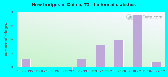
- New bridges - historical statistics
- 31950-1959
- 31980-1989
- 81990-1999
- 102000-2009
- 192010-2019
- 22020-2022
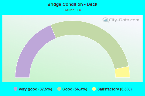
- Bridge Condition - Deck
- 37.5%Very good
- 56.3%Good
- 6.3%Satisfactory
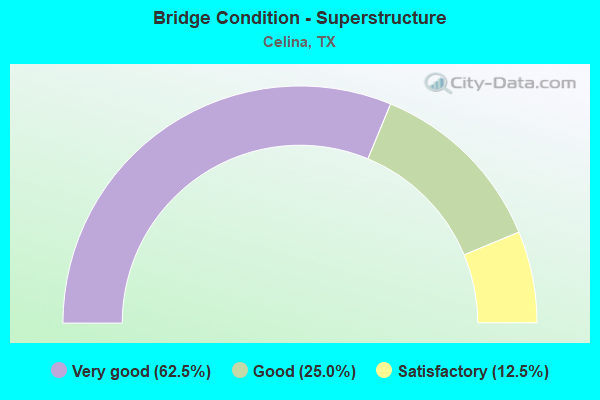
- Bridge Condition - Superstructure
- 62.5%Very good
- 25.0%Good
- 12.5%Satisfactory
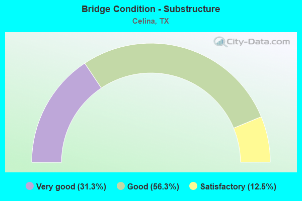
- Bridge Condition - Substructure
- 31.3%Very good
- 56.3%Good
- 12.5%Satisfactory
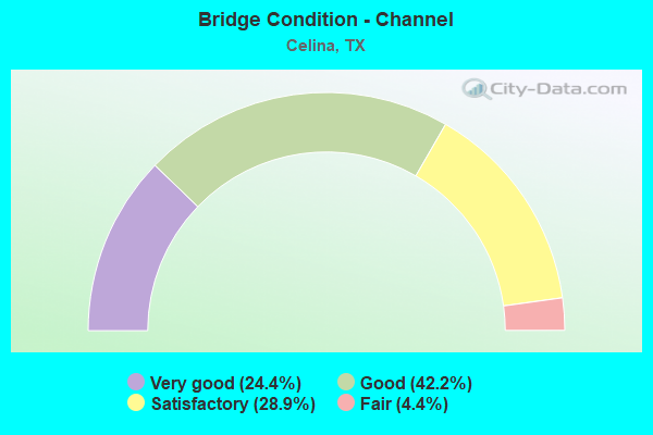
- Bridge Condition - Channel
- 24.4%Very good
- 42.2%Good
- 28.9%Satisfactory
- 4.4%Fair
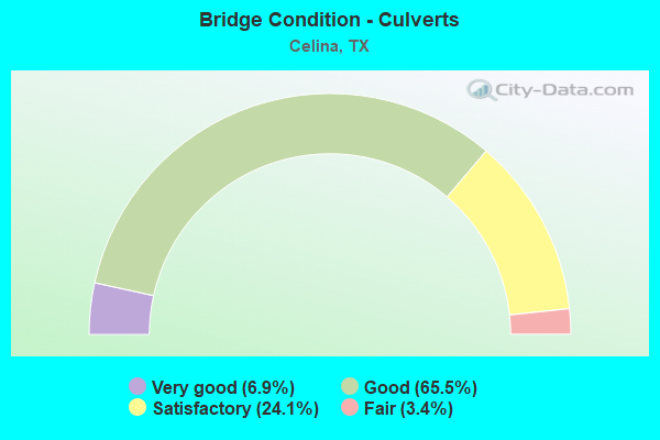
- Bridge Condition - Culverts
- 6.9%Very good
- 65.5%Good
- 24.1%Satisfactory
- 3.4%Fair
Find on map >> Show street view
Structure Number: 180610AA0276001, Location: 1.40 MI E OF FM 1385 (Lat: 33.316447, Lng: -96.866575), Route carried "on" structure: County highway , Year Built: 2005, Status: Open, Structure Length: 1.55m (5.09ft), Average Daily Traffic: 62 (year 2012), Average Future Daily Traffic: 200 (year 2030), Design Load: HS 20, Features Intersected: LITTLE ELM CREEK, Facility Carried by Structure: MOBBERLY RD
Minimum Vertical Clearance: 30+ m (98+ ft), Kilometerpoint: 2.253, Lanes on structure: 2, Owner: County Highway Agency, Approaching Roadway Width: 7.3m (24.0ft), Skew: 3 degrees, Material/Design: Concrete, Design/Construction: Culvert, Number Of Spans In Main Unit: 4, Length of Maximum Span: 3.0m (9.8ft), Curb-To-Curb Width: 7.3m (24.0ft), Out-to-Out Width: 16.5m (54.1ft)
Condition: Channel: Satisfactory, Culverts: Good, Operating Rating: 54.4 metric tons, Method Used To Determine Operating Rating: Assigned rating based on Load Factor Design (LFD) reported in metric tons, Inventory Rating: 32.7 metric tons, Method Used To Determine Inventory Rating: Assigned rating based on Load Factor Design (LFD) reported in metric tons, Structural Evaluation: Better than present minimum criteria, Deck Geometry: Equal to present minimum criteria, Waterway Adequacy: Meets minimum limits, Approach Roadway Alignment: Equal to present desirable criteria, Length Of Structure Improvement: 2.59m (8.50ft), Designated Inspection Frequency: Every 24 months, Inspection Date: December 2020, Bridge Improvement Cost: $4,000, Roadway Improvement Cost: $1,000, Total Project Cost: $5,000, Deck Structure Type: Concrete Cast-file-Place, Wearing Surface/Protective System: Wearing Surface: Bituminous
Find on map >> Show street view
Structure Number: 180610AA0276002, Location: 1.30 MI E OF FM 1385 (Lat: 33.316400, Lng: -96.867850), Route carried "on" structure: County highway , Year Built: 2007, Status: Open, Structure Length: 0.70m (2.30ft), Average Daily Traffic: 62 (year 2012), Average Future Daily Traffic: 200 (year 2030), Features Intersected: LITTLE ELM CREEK TRIB, Facility Carried by Structure: MOBBERLY RD
Minimum Vertical Clearance: 30+ m (98+ ft), Kilometerpoint: 2.092, Lanes on structure: 2, Owner: County Highway Agency, Approaching Roadway Width: 7.3m (24.0ft), Skew: 3 degrees, Material/Design: Concrete, Design/Construction: Culvert, Number Of Spans In Main Unit: 2, Length of Maximum Span: 2.7m (8.9ft)
Condition: Channel: Satisfactory, Culverts: Satisfactory, Operating Rating: 32.7 metric tons, Method Used To Determine Operating Rating: Field evaluation and documented engineering judgment, Inventory Rating: 24.5 metric tons, Method Used To Determine Inventory Rating: Field evaluation and documented engineering judgment, Structural Evaluation: Equal to present minimum criteria, Waterway Adequacy: Meets minimum limits, Approach Roadway Alignment: Equal to present desirable criteria, Designated Inspection Frequency: Every 24 months, Inspection Date: December 2020
Find on map >> Show street view
Structure Number: 180610AA0312002, Location: 1.4 Mi E of FM 1385 (Lat: 33.321856, Lng: -96.844064), Route carried "on" structure: County highway , Year Built: 2017, Status: Open, Structure Length: 2.74m (8.99ft), Average Daily Traffic: 40 (year 2016), Truck Traffic: 3%, Average Future Daily Traffic: 70 (year 2036), Design Load: HL 93, Features Intersected: Little Elm Creek Trib., Facility Carried by Structure: Mobberly Rd.
Minimum Vertical Clearance: 30+ m (98+ ft), Kilometerpoint: 0.000, Lanes on structure: 2, Owner: County Highway Agency, Approaching Roadway Width: 4.3m (14.1ft), Material/Design: Prestressed concrete, Design/Construction: Slab, Number Of Spans In Main Unit: 3, Length of Maximum Span: 9.1m (29.9ft), Curb-To-Curb Width: 7.0m (23.0ft), Out-to-Out Width: 7.9m (25.9ft)
Condition: Deck: Very good, Superstructure: Very good, Substructure: Very good, Channel: Very good, Operating Rating: 54.4 metric tons, Method Used To Determine Operating Rating: Assigned ratings based on Load and Resistance Factor Design (LRFD) reported in metric tons, Inventory Rating: 32.7 metric tons, Method Used To Determine Inventory Rating: Assigned ratings based on Load and Resistance Factor Design (LRFD) reported in metric tons, Structural Evaluation: Equal to present desirable criteria, Deck Geometry: Somewhat better than minimum adequacy, Waterway Adequacy: Better than present minimum criteria, Approach Roadway Alignment: Equal to present desirable criteria, Designated Inspection Frequency: Every 24 months, Inspection Date: November 2021, Deck Structure Type: Concrete Cast-file-Place