Bridge Statistics for Centennial, Colorado (CO)
Condition, Traffic, Stress, Structural Evaluation, Project Costs
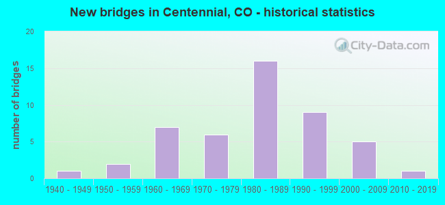
- New bridges - historical statistics
- 11940-1949
- 21950-1959
- 71960-1969
- 61970-1979
- 161980-1989
- 91990-1999
- 52000-2009
- 12010-2019
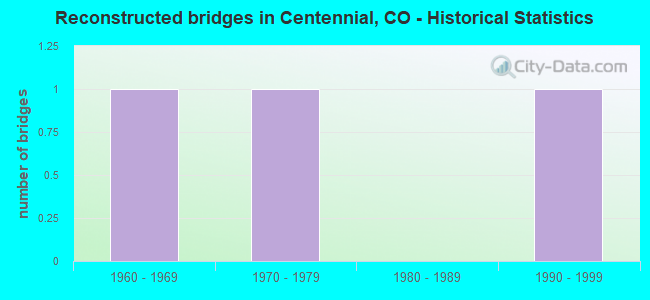
- Reconstructed bridges - Historical Statistics
- 11960-1969
- 11970-1979
- 01980-1989
- 11990-1999
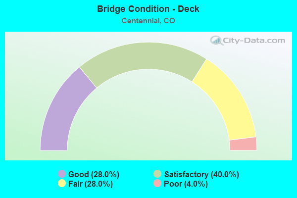
- Bridge Condition - Deck
- 28.0%Good
- 40.0%Satisfactory
- 28.0%Fair
- 4.0%Poor
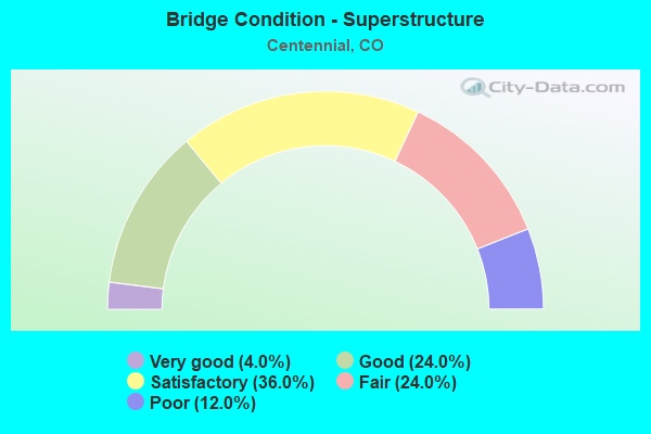
- Bridge Condition - Superstructure
- 4.0%Very good
- 24.0%Good
- 36.0%Satisfactory
- 24.0%Fair
- 12.0%Poor
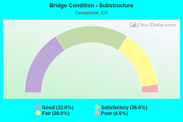
- Bridge Condition - Substructure
- 32.0%Good
- 36.0%Satisfactory
- 28.0%Fair
- 4.0%Poor
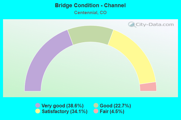
- Bridge Condition - Channel
- 38.6%Very good
- 22.7%Good
- 34.1%Satisfactory
- 4.5%Fair
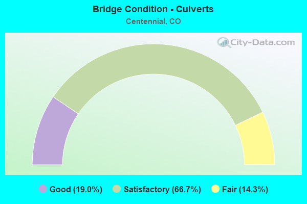
- Bridge Condition - Culverts
- 19.0%Good
- 66.7%Satisfactory
- 14.3%Fair
Find on map >> Show street view
Structure Number: ARA 41.5-1.2, Location: .4 MI S OF E EASTER AVE (Lat: 39.582794, Lng: -104.860558), Route carried "on" structure: County highway , Year Built: 1989, Status: Open, Structure Length: 0.75m (2.46ft), Average Daily Traffic: 212 (year 2021), Average Future Daily Traffic: 258 (year 2041), Design Load: HS 20, Features Intersected: COTTONWOOD CREEK TRIB., Facility Carried by Structure: JOLIET ST
Minimum Vertical Clearance: 30+ m (98+ ft), Kilometerpoint: 0.014, Lanes on structure: 4, Owner: County Highway Agency, Approaching Roadway Width: 19.5m (64.0ft), Skew: 3 degrees, Material/Design: Concrete, Design/Construction: Culvert, Number Of Spans In Main Unit: 3, Length of Maximum Span: 1.9m (6.2ft), Curb or Sidewalk Widths: Left: 0.0m, Right: 1.8m (5.9ft), Out-to-Out Width: 52.1m (170.9ft)
Condition: Channel: Satisfactory, Culverts: Satisfactory, Operating Rating: 36.3 metric tons, Method Used To Determine Operating Rating: Field evaluation and documented engineering judgment, Inventory Rating: 32.7 metric tons, Method Used To Determine Inventory Rating: Field evaluation and documented engineering judgment, Structural Evaluation: Equal to present minimum criteria, Waterway Adequacy: Equal to present desirable criteria, Approach Roadway Alignment: Equal to present minimum criteria, Designated Inspection Frequency: Every 24 months, Inspection Date: November 2021
Find on map >> Show street view
Structure Number: ARA 44-10.4, Location: 0.1 MI W of LIMA ST (Lat: 39.587544, Lng: -104.858675), Route carried "on" structure: County highway , Year Built: 1988, Status: Open, Structure Length: 0.95m (3.12ft), Average Daily Traffic: 13,074 (year 2021), Truck Traffic: 2%, Average Future Daily Traffic: 15,950 (year 2041), Design Load: HS 20, Features Intersected: COTTONWOOD CREEK, Facility Carried by Structure: EASTER AVE
Minimum Vertical Clearance: 30+ m (98+ ft), Kilometerpoint: 0.718, Lanes on structure: 6, Owner: County Highway Agency, Approaching Roadway Width: 26.8m (87.9ft), Skew: 20 degrees, Material/Design: Concrete, Design/Construction: Culvert, Number Of Spans In Main Unit: 3, Length of Maximum Span: 3.0m (9.8ft), Curb or Sidewalk Widths: Left: 0.0m, Right: 1.8m (5.9ft), Out-to-Out Width: 51.8m (169.9ft)
Condition: Channel: Very good, Culverts: Fair, Operating Rating: 36.3 metric tons, Method Used To Determine Operating Rating: Field evaluation and documented engineering judgment, Inventory Rating: 32.7 metric tons, Method Used To Determine Inventory Rating: Field evaluation and documented engineering judgment, Structural Evaluation: Somewhat better than minimum adequacy, Waterway Adequacy: Equal to present desirable criteria, Approach Roadway Alignment: Equal to present desirable criteria, Designated Inspection Frequency: Every 24 months, Inspection Date: November 2021
Find on map >> Show street view
Structure Number: ARA 49.2-12.2, Location: .2 MI S OF FREMONT AVE (Lat: 39.581742, Lng: -104.823269), Route carried "on" structure: County highway , Year Built: 1994, Status: Open, Structure Length: 0.80m (2.62ft), Average Daily Traffic: 11,510 (year 2021), Average Future Daily Traffic: 14,042 (year 2041), Design Load: HS 20, Features Intersected: CHERRY CREEK TRIB, Facility Carried by Structure: BLACKHAWK ST
Minimum Vertical Clearance: 30+ m (98+ ft), Kilometerpoint: 0.137, Lanes on structure: 3, Owner: County Highway Agency, Approaching Roadway Width: 13.7m (44.9ft), Skew: 2 degrees, Material/Design: Concrete, Design/Construction: Culvert, Number Of Spans In Main Unit: 2, Length of Maximum Span: 3.9m (12.8ft), Out-to-Out Width: 18.5m (60.7ft)
Condition: Channel: Good, Culverts: Satisfactory, Operating Rating: 36.3 metric tons, Method Used To Determine Operating Rating: Field evaluation and documented engineering judgment, Inventory Rating: 32.7 metric tons, Method Used To Determine Inventory Rating: Field evaluation and documented engineering judgment, Structural Evaluation: Equal to present minimum criteria, Waterway Adequacy: Equal to present desirable criteria, Approach Roadway Alignment: Equal to present desirable criteria, Designated Inspection Frequency: Every 24 months, Inspection Date: November 2021
Find on map >> Show street view
Structure Number: ARA 61-14.8, Location: 0.4 MI S OF ORCHARD RD (Lat: 39.603994, Lng: -104.775597), Route carried "on" structure: County highway , Year Built: 1998, Status: Open, Structure Length: 4.49m (14.73ft), Average Daily Traffic: 4,463 (year 2021), Truck Traffic: 1%, Average Future Daily Traffic: 5,445 (year 2041), Design Load: HS 25 or greater, Features Intersected: PINEY CREEK, Facility Carried by Structure: TOWER ROAD
Minimum Vertical Clearance: 30+ m (98+ ft), Kilometerpoint: 0.629, Lanes on structure: 2, Owner: County Highway Agency, Approaching Roadway Width: 11.0m (36.1ft), Material/Design: Prestressed concrete continuous, Design/Construction: Stringer/Multi-beam, Number Of Spans In Main Unit: 2, Length of Maximum Span: 22.3m (73.2ft), Curb or Sidewalk Widths: Left: 1.7m (5.6ft), Right: 1.7m (5.6ft), Curb-To-Curb Width: 9.8m (32.2ft), Out-to-Out Width: 14.1m (46.3ft)
Condition: Deck: Good, Superstructure: Good, Substructure: Good, Channel: Very good, Operating Rating: 78.9 metric tons, Method Used To Determine Operating Rating: Load Factor (LF), Inventory Rating: 47.4 metric tons, Method Used To Determine Inventory Rating: Load Factor (LF), Structural Evaluation: Better than present minimum criteria, Deck Geometry: Meets minimum limits, Waterway Adequacy: Equal to present desirable criteria, Approach Roadway Alignment: Equal to present desirable criteria, Designated Inspection Frequency: Every 24 months, Inspection Date: November 2021, Deck Structure Type: Concrete Cast-file-Place, Wearing Surface/Protective System: Wearing Surface: Monolithic Concrete, Deck Protection: Epoxy Coated Reinforcing
Find on map >> Show street view
Structure Number: CENT 15-1.7, Location: 0.3 MI S OF ARAPAHOE RD (Lat: 39.590497, Lng: -104.988172), Route carried "on" structure: City street , Year Built: 1966, Status: Open, Structure Length: 0.98m (3.22ft), Average Daily Traffic: 1,796 (year 2021), Truck Traffic: 5%, Average Future Daily Traffic: 2,191 (year 2041), Features Intersected: HIGHLINE CANAL, Facility Carried by Structure: BROADWAY
Minimum Vertical Clearance: 30+ m (98+ ft), Kilometerpoint: 0.313, Lanes on structure: 5, Base Highway Network: Yes, Owner: City or Municipal Highway Agency, Approaching Roadway Width: 25.6m (84.0ft), Skew: 1 degrees, Material/Design: Prestressed concrete, Design/Construction: Tee Beam, Number Of Spans In Main Unit: 1, Length of Maximum Span: 9.1m (29.9ft), Curb or Sidewalk Widths: Left: 1.2m (3.9ft), Right: 1.2m (3.9ft), Curb-To-Curb Width: 25.8m (84.6ft), Out-to-Out Width: 28.3m (92.8ft)
Condition: Deck: Fair, Superstructure: Fair, Substructure: Satisfactory, Channel: Very good, Operating Rating: 32.7 metric tons, Method Used To Determine Operating Rating: Field evaluation and documented engineering judgment, Inventory Rating: 24.5 metric tons, Method Used To Determine Inventory Rating: Field evaluation and documented engineering judgment, Structural Evaluation: Somewhat better than minimum adequacy, Deck Geometry: Superior to present desirable criteria, Waterway Adequacy: Equal to present desirable criteria, Approach Roadway Alignment: Equal to present desirable criteria, Designated Inspection Frequency: Every 24 months, Inspection Date: October 2021, Deck Structure Type: Other, Wearing Surface/Protective System: Wearing Surface: Bituminous
Find on map >> Show street view
Structure Number: CENT 15-1.9, Location: JUST S OF ARAPAHOE RD (Lat: 39.594517, Lng: -104.988275), Route carried "on" structure: City street , Year Built: 1958, Status: Open, Structure Length: 1.09m (3.58ft), Average Daily Traffic: 30,424 (year 2021), Truck Traffic: 5%, Average Future Daily Traffic: 37,117 (year 2041), Features Intersected: HIGHLINE CANAL, Facility Carried by Structure: BROADWAY
Minimum Vertical Clearance: 30+ m (98+ ft), Kilometerpoint: 0.023, Lanes on structure: 5, Base Highway Network: Yes, Owner: City or Municipal Highway Agency, Approaching Roadway Width: 25.6m (84.0ft), Skew: 1 degrees, Material/Design: Prestressed concrete, Design/Construction: Tee Beam, Number Of Spans In Main Unit: 1, Length of Maximum Span: 10.1m (33.1ft), Curb or Sidewalk Widths: Left: 2.3m (7.5ft), Right: 0.9m (3.0ft), Curb-To-Curb Width: 25.6m (84.0ft), Out-to-Out Width: 28.8m (94.5ft)
Condition: Deck: Fair, Superstructure: Fair, Substructure: Fair, Channel: Very good, Operating Rating: 32.7 metric tons, Method Used To Determine Operating Rating: Field evaluation and documented engineering judgment, Inventory Rating: 24.5 metric tons, Method Used To Determine Inventory Rating: Field evaluation and documented engineering judgment, Structural Evaluation: Somewhat better than minimum adequacy, Deck Geometry: Superior to present desirable criteria, Waterway Adequacy: Equal to present desirable criteria, Approach Roadway Alignment: Equal to present desirable criteria, Designated Inspection Frequency: Every 24 months, Inspection Date: October 2021, Deck Structure Type: Other, Wearing Surface/Protective System: Wearing Surface: Bituminous, Membrane: Built-up
Find on map >> Show street view
Structure Number: CENT 15-2.5, Location: 0.5 MI N OF ARAPAHOE RD (Lat: 39.602372, Lng: -104.988169), Route carried "on" structure: City street , Year Built: 1974, Status: Open, Structure Length: 1.25m (4.10ft), Average Daily Traffic: 35,473 (year 2021), Truck Traffic: 5%, Average Future Daily Traffic: 43,277 (year 2041), Features Intersected: HIGHLINE CANAL, Facility Carried by Structure: BROADWAY
Minimum Vertical Clearance: 30+ m (98+ ft), Kilometerpoint: 0.454, Lanes on structure: 5, Base Highway Network: Yes, Owner: City or Municipal Highway Agency, Approaching Roadway Width: 23.2m (76.1ft), Skew: 9 degrees, Material/Design: Concrete, Design/Construction: Frame, Number Of Spans In Main Unit: 1, Length of Maximum Span: 11.7m (38.4ft), Curb or Sidewalk Widths: Left: 2.1m (6.9ft), Right: 2.1m (6.9ft), Curb-To-Curb Width: 23.3m (76.4ft), Out-to-Out Width: 27.6m (90.6ft)
Condition: Deck: Satisfactory, Superstructure: Satisfactory, Substructure: Satisfactory, Channel: Very good, Inventory Rating: 62.1 metric tons, Method Used To Determine Inventory Rating: Load Factor (LF), Structural Evaluation: Equal to present minimum criteria, Deck Geometry: Better than present minimum criteria, Waterway Adequacy: Equal to present desirable criteria, Approach Roadway Alignment: Equal to present desirable criteria, Designated Inspection Frequency: Every 24 months, Inspection Date: October 2021, Deck Structure Type: Concrete Cast-file-Place, Wearing Surface/Protective System: Wearing Surface: Bituminous
Find on map >> Show street view
Structure Number: CENT 17-2.3, Location: .1 MILE N OF PANAMA DRIVE (Lat: 39.599797, Lng: -104.978206), Route carried "on" structure: City street , Year Built: 1950, Status: Posted for load, Structure Length: 0.85m (2.79ft), Average Daily Traffic: 2,529 (year 2021), Truck Traffic: 2%, Average Future Daily Traffic: 3,085 (year 2041), Features Intersected: HIGHLINE CANAL, Facility Carried by Structure: CLARKSON ST
Minimum Vertical Clearance: 30+ m (98+ ft), Kilometerpoint: 3.916, Lanes on structure: 2, Owner: City or Municipal Highway Agency, Approaching Roadway Width: 12.2m (40.0ft), Material/Design: Steel, Design/Construction: Stringer/Multi-beam, Number Of Spans In Main Unit: 1, Length of Maximum Span: 7.9m (25.9ft), Curb or Sidewalk Widths: Left: 1.1m (3.6ft), Right: 1.1m (3.6ft), Curb-To-Curb Width: 11.0m (36.1ft), Out-to-Out Width: 14.8m (48.6ft)
Condition: Deck: Satisfactory, Superstructure: Fair, Substructure: Good, Channel: Very good, Operating Rating: 14.8 metric tons, Method Used To Determine Operating Rating: Load Factor (LF), Inventory Rating: 8.8 metric tons, Method Used To Determine Inventory Rating: Load Factor (LF), Structural Evaluation: High priority of corrective action, Deck Geometry: Somewhat better than minimum adequacy, Waterway Adequacy: Equal to present desirable criteria, Approach Roadway Alignment: Equal to present desirable criteria, Bridge Posting: Required (Relationship of Operating Rating to Maximum Legal Load: > 39.9% below), Designated Inspection Frequency: Every 24 months, Inspection Date: October 2021, Deck Structure Type: Concrete Cast-file-Place, Wearing Surface/Protective System: Wearing Surface: Bituminous
Find on map >> Show street view
Structure Number: CENT 17.6-2.9, Location: JUST SOUTH OF ORCHARD RD (Lat: 39.609486, Lng: -104.972686), Route carried "on" structure: City street , Year Built: 1965, Status: Open, Structure Length: 0.91m (2.99ft), Average Daily Traffic: 158 (year 2021), Truck Traffic: 4%, Average Future Daily Traffic: 192 (year 2041), Features Intersected: BIG DRY CREEK, Facility Carried by Structure: CHERRYWOOD CIR.
Minimum Vertical Clearance: 30+ m (98+ ft), Kilometerpoint: 0.884, Lanes on structure: 2, Owner: City or Municipal Highway Agency, Approaching Roadway Width: 11.0m (36.1ft), Material/Design: Prestressed concrete, Design/Construction: Tee Beam, Number Of Spans In Main Unit: 1, Length of Maximum Span: 8.5m (27.9ft), Curb-To-Curb Width: 8.1m (26.6ft), Out-to-Out Width: 9.1m (29.9ft)
Condition: Deck: Fair, Superstructure: Fair, Substructure: Fair, Channel: Satisfactory, Operating Rating: 36.3 metric tons, Method Used To Determine Operating Rating: Field evaluation and documented engineering judgment, Inventory Rating: 32.7 metric tons, Method Used To Determine Inventory Rating: Field evaluation and documented engineering judgment, Structural Evaluation: Somewhat better than minimum adequacy, Deck Geometry: Somewhat better than minimum adequacy, Waterway Adequacy: Equal to present desirable criteria, Approach Roadway Alignment: Equal to present desirable criteria, Designated Inspection Frequency: Every 24 months, Inspection Date: October 2021, Deck Structure Type: Other, Wearing Surface/Protective System: Wearing Surface: Monolithic Concrete
Find on map >> Show street view
Structure Number: CENT 19-2.5, Location: .2 MI SOUTH OF ORCHARD RD (Lat: 39.606547, Lng: -104.969353), Route carried "on" structure: City street , Year Built: 1968, Status: Open, Structure Length: 0.91m (2.99ft), Average Daily Traffic: 242 (year 2021), Truck Traffic: 2%, Average Future Daily Traffic: 295 (year 2041), Features Intersected: BIG DRY CREEK, Facility Carried by Structure: FRANKLIN ST
Minimum Vertical Clearance: 30+ m (98+ ft), Kilometerpoint: 0.161, Lanes on structure: 2, Owner: City or Municipal Highway Agency, Approaching Roadway Width: 6.2m (20.3ft), Material/Design: Prestressed concrete, Design/Construction: Tee Beam, Number Of Spans In Main Unit: 1, Length of Maximum Span: 8.5m (27.9ft), Curb-To-Curb Width: 9.1m (29.9ft), Out-to-Out Width: 9.1m (29.9ft)
Condition: Deck: Satisfactory, Superstructure: Satisfactory, Substructure: Fair, Channel: Satisfactory, Operating Rating: 36.3 metric tons, Method Used To Determine Operating Rating: Field evaluation and documented engineering judgment, Inventory Rating: 32.7 metric tons, Method Used To Determine Inventory Rating: Field evaluation and documented engineering judgment, Structural Evaluation: Somewhat better than minimum adequacy, Deck Geometry: Equal to present minimum criteria, Waterway Adequacy: Equal to present desirable criteria, Approach Roadway Alignment: Equal to present desirable criteria, Designated Inspection Frequency: Every 24 months, Inspection Date: October 2021, Deck Structure Type: Other, Wearing Surface/Protective System: Wearing Surface: Bituminous
Find on map >> Show street view
Structure Number: CENT 23.9-2.9A, Location: .1 MI S OF ORCHARD RD (Lat: 39.607706, Lng: -104.941828), Route carried "on" structure: City street , Year Built: 2000, Status: Open, Structure Length: 1.25m (4.10ft), Average Daily Traffic: 69 (year 2021), Truck Traffic: 1%, Average Future Daily Traffic: 85 (year 2041), Design Load: HS 20+Mod, Features Intersected: LITTLE DRY CREEK, Facility Carried by Structure: BROOK VALLEY WAY
Minimum Vertical Clearance: 30+ m (98+ ft), Kilometerpoint: 0.172, Lanes on structure: 2, Owner: City or Municipal Highway Agency, Approaching Roadway Width: 7.3m (24.0ft), Material/Design: Prestressed concrete, Design/Construction: Tee Beam, Number Of Spans In Main Unit: 1, Length of Maximum Span: 11.3m (37.1ft), Curb-To-Curb Width: 8.2m (26.9ft), Out-to-Out Width: 9.1m (29.9ft)
Condition: Deck: Good, Superstructure: Good, Substructure: Good, Channel: Satisfactory, Operating Rating: 37.3 metric tons, Method Used To Determine Operating Rating: Load Factor (LF), Inventory Rating: 22.3 metric tons, Method Used To Determine Inventory Rating: Load Factor (LF), Structural Evaluation: Equal to present minimum criteria, Deck Geometry: Equal to present minimum criteria, Waterway Adequacy: Equal to present desirable criteria, Approach Roadway Alignment: Equal to present minimum criteria, Designated Inspection Frequency: Every 24 months, Inspection Date: October 2021, Deck Structure Type: Concrete Cast-file-Place, Wearing Surface/Protective System: Wearing Surface: Monolithic Concrete, Deck Protection: Epoxy Coated Reinforcing
Find on map >> Show street view
Structure Number: CENT 25-0.6, Location: .6 MI N OF COUNTY LINE RD (Lat: 39.574700, Lng: -104.941556), Route carried "on" structure: City street , Year Built: 1989, Status: Open, Structure Length: 4.85m (15.91ft), Average Daily Traffic: 9,445 (year 2021), Truck Traffic: 2%, Average Future Daily Traffic: 11,523 (year 2041), Design Load: HS 20, Features Intersected: BIG DRY CREEK, Facility Carried by Structure: COLORADO BLVD
Minimum Vertical Clearance: 30+ m (98+ ft), Kilometerpoint: 0.959, Lanes on structure: 2, Owner: City or Municipal Highway Agency, Approaching Roadway Width: 15.9m (52.2ft), Skew: 2 degrees, Material/Design: Prestressed concrete continuous, Design/Construction: Box Beam or Girders - Single/Spread, Number Of Spans In Main Unit: 2, Length of Maximum Span: 22.6m (74.1ft), Curb or Sidewalk Widths: Left: 1.5m (4.9ft), Right: 1.5m (4.9ft), Curb-To-Curb Width: 15.9m (52.2ft), Out-to-Out Width: 19.7m (64.6ft)
Condition: Deck: Satisfactory, Superstructure: Satisfactory, Substructure: Satisfactory, Channel: Very good, Operating Rating: 26.9 metric tons, Method Used To Determine Operating Rating: Load Factor (LF), Inventory Rating: 16.1 metric tons, Method Used To Determine Inventory Rating: Load Factor (LF), Structural Evaluation: High priority of corrective action, Deck Geometry: Superior to present desirable criteria, Waterway Adequacy: Equal to present desirable criteria, Approach Roadway Alignment: Equal to present desirable criteria, Designated Inspection Frequency: Every 24 months, Inspection Date: October 2021, Deck Structure Type: Concrete Cast-file-Place, Wearing Surface/Protective System: Wearing Surface: Monolithic Concrete
Find on map >> Show street view
Structure Number: CENT 25-2.7, Location: 0.4 MI. S. OF ORCHARD RD (Lat: 39.603558, Lng: -104.936031), Route carried "on" structure: City street , Year Built: 1970, Status: Open, Structure Length: 0.98m (3.22ft), Average Daily Traffic: 4,036 (year 2021), Truck Traffic: 6%, Average Future Daily Traffic: 4,924 (year 2041), Features Intersected: LITTLE DRY CREEK, Facility Carried by Structure: COLORADO BLVD
Minimum Vertical Clearance: 30+ m (98+ ft), Kilometerpoint: 4.450, Lanes on structure: 2, Owner: City or Municipal Highway Agency, Approaching Roadway Width: 15.9m (52.2ft), Skew: 2 degrees, Material/Design: Prestressed concrete, Design/Construction: Tee Beam, Number Of Spans In Main Unit: 1, Length of Maximum Span: 8.8m (28.9ft), Curb or Sidewalk Widths: Left: 0.8m (2.6ft), Right: 0.8m (2.6ft), Curb-To-Curb Width: 15.9m (52.2ft), Out-to-Out Width: 18.3m (60.0ft)
Condition: Deck: Satisfactory, Superstructure: Poor, Substructure: Poor, Channel: Very good, Operating Rating: 32.7 metric tons, Method Used To Determine Operating Rating: Field evaluation and documented engineering judgment, Inventory Rating: 24.5 metric tons, Method Used To Determine Inventory Rating: Field evaluation and documented engineering judgment, Structural Evaluation: Meets minimum limits, Deck Geometry: Superior to present desirable criteria, Waterway Adequacy: Equal to present desirable criteria, Approach Roadway Alignment: Equal to present desirable criteria, Designated Inspection Frequency: Every 24 months, Inspection Date: October 2021, Deck Structure Type: Concrete Cast-file-Place, Wearing Surface/Protective System: Wearing Surface: Bituminous
Find on map >> Show street view
Structure Number: CENT 33-0.8, Location: .2 MILE S OF DRY CREEK (Lat: 39.576433, Lng: -104.904178), Route carried "on" structure: City street , Year Built: 1968, Year Reconstructed: 1974, Status: Open, Structure Length: 1.03m (3.38ft), Average Daily Traffic: 16,295 (year 2021), Truck Traffic: 5%, Average Future Daily Traffic: 19,880 (year 2041), Features Intersected: WILLOW CREEK, Facility Carried by Structure: QUEBEC STREET
Minimum Vertical Clearance: 30+ m (98+ ft), Kilometerpoint: 1.244, Lanes on structure: 4, Base Highway Network: Yes, Owner: City or Municipal Highway Agency, Approaching Roadway Width: 16.3m (53.5ft), Skew: 3 degrees, Material/Design: Concrete, Design/Construction: Culvert, Number Of Spans In Main Unit: 2, Length of Maximum Span: 5.0m (16.4ft), Curb or Sidewalk Widths: Left: 2.6m (8.5ft), Right: 2.6m (8.5ft), Curb-To-Curb Width: 16.0m (52.5ft), Out-to-Out Width: 22.1m (72.5ft)
Condition: Channel: Good, Culverts: Satisfactory, Operating Rating: 36.3 metric tons, Method Used To Determine Operating Rating: Field evaluation and documented engineering judgment, Inventory Rating: 32.7 metric tons, Method Used To Determine Inventory Rating: Field evaluation and documented engineering judgment, Structural Evaluation: Equal to present minimum criteria, Deck Geometry: Meets minimum limits, Waterway Adequacy: Equal to present desirable criteria, Approach Roadway Alignment: Equal to present desirable criteria, Designated Inspection Frequency: Every 24 months, Inspection Date: October 2021
Find on map >> Show street view
Structure Number: CENT 34-12.8, Location: .2 MI E OF JORDAN RD (Lat: 39.586642, Lng: -104.810861), Route carried "on" structure: City street , Year Built: 1985, Status: Open, Structure Length: 1.00m (3.28ft), Average Daily Traffic: 1,205 (year 2021), Truck Traffic: 2%, Average Future Daily Traffic: 1,470 (year 2041), Design Load: HS 20, Features Intersected: DOVE CREEK, Facility Carried by Structure: E. FREMONT DR
Minimum Vertical Clearance: 30+ m (98+ ft), Kilometerpoint: 0.409, Lanes on structure: 2, Owner: City or Municipal Highway Agency, Approaching Roadway Width: 13.4m (44.0ft), Skew: 1 degrees, Material/Design: Concrete, Design/Construction: Culvert, Number Of Spans In Main Unit: 3, Length of Maximum Span: 3.8m (12.5ft), Curb or Sidewalk Widths: Left: 1.4m (4.6ft), Right: 1.7m (5.6ft), Curb-To-Curb Width: 13.6m (44.6ft), Out-to-Out Width: 17.5m (57.4ft)
Condition: Channel: Very good, Culverts: Good, Inventory Rating: 98.4 metric tons, Method Used To Determine Inventory Rating: Load Factor (LF), Structural Evaluation: Better than present minimum criteria, Deck Geometry: Superior to present desirable criteria, Waterway Adequacy: Equal to present desirable criteria, Approach Roadway Alignment: Equal to present desirable criteria, Designated Inspection Frequency: Every 24 months, Inspection Date: October 2021
Find on map >> Show street view
Structure Number: CENT 34-12.9, Location: .1 MI S OF FREMONT (Lat: 39.584275, Lng: -104.812114), Route carried "on" structure: City street , Year Built: 1985, Status: Open, Structure Length: 0.96m (3.15ft), Average Daily Traffic: 780 (year 2021), Truck Traffic: 1%, Average Future Daily Traffic: 951 (year 2041), Design Load: HS 20, Features Intersected: DOVE CREEK, Facility Carried by Structure: FRASER STREET
Minimum Vertical Clearance: 30+ m (98+ ft), Kilometerpoint: 0.201, Lanes on structure: 2, Owner: City or Municipal Highway Agency, Approaching Roadway Width: 13.1m (43.0ft), Material/Design: Concrete, Design/Construction: Culvert, Number Of Spans In Main Unit: 3, Length of Maximum Span: 3.7m (12.1ft), Curb or Sidewalk Widths: Left: 2.4m (7.9ft), Right: 2.1m (6.9ft), Curb-To-Curb Width: 13.1m (43.0ft), Out-to-Out Width: 18.1m (59.4ft)
Condition: Channel: Good, Culverts: Satisfactory, Inventory Rating: 98.6 metric tons, Method Used To Determine Inventory Rating: Load Factor (LF), Structural Evaluation: Equal to present minimum criteria, Deck Geometry: Superior to present desirable criteria, Waterway Adequacy: Equal to present desirable criteria, Approach Roadway Alignment: Equal to present desirable criteria, Designated Inspection Frequency: Every 24 months, Inspection Date: October 2021
Find on map >> Show street view
Structure Number: CENT 34-16.1, Location: JUST E OF HIMALAYA CT (Lat: 39.626497, Lng: -104.752044), Route carried "on" structure: City street , Year Built: 1994, Status: Open, Structure Length: 0.63m (2.07ft), Average Daily Traffic: 10,350 (year 2021), Truck Traffic: 2%, Average Future Daily Traffic: 12,627 (year 2041), Design Load: HS 20, Features Intersected: TOLLGATE CREEK, Facility Carried by Structure: CHENANGO DR
Minimum Vertical Clearance: 30+ m (98+ ft), Kilometerpoint: 0.154, Lanes on structure: 5, Owner: City or Municipal Highway Agency, Approaching Roadway Width: 20.7m (67.9ft), Material/Design: Concrete, Design/Construction: Culvert, Number Of Spans In Main Unit: 2, Length of Maximum Span: 3.0m (9.8ft), Curb or Sidewalk Widths: Left: 2.0m (6.6ft), Right: 2.1m (6.9ft), Curb-To-Curb Width: 20.8m (68.2ft), Out-to-Out Width: 34.1m (111.9ft)
Condition: Channel: Satisfactory, Culverts: Satisfactory, Inventory Rating: 71.4 metric tons, Method Used To Determine Inventory Rating: Load Factor (LF), Structural Evaluation: Equal to present minimum criteria, Deck Geometry: Somewhat better than minimum adequacy, Waterway Adequacy: Better than present minimum criteria, Approach Roadway Alignment: Equal to present desirable criteria, Designated Inspection Frequency: Every 24 months, Inspection Date: October 2021
Find on map >> Show street view
Structure Number: CENT 38-4.2, Location: .7 MI E OF BROADWAY (Lat: 39.609642, Lng: -104.974956), Route carried "on" structure: City street , Year Built: 1967, Status: Open, Structure Length: 1.23m (4.04ft), Average Daily Traffic: 7,806 (year 2021), Truck Traffic: 3%, Average Future Daily Traffic: 9,524 (year 2041), Design Load: HS 20, Features Intersected: BIG DRY CREEK, Facility Carried by Structure: ORCHARD ROAD
Minimum Vertical Clearance: 30+ m (98+ ft), Kilometerpoint: 0.958, Lanes on structure: 3, Owner: City or Municipal Highway Agency, Approaching Roadway Width: 12.2m (40.0ft), Skew: 3 degrees, Material/Design: Prestressed concrete, Design/Construction: Tee Beam, Number Of Spans In Main Unit: 1, Length of Maximum Span: 11.6m (38.1ft), Curb or Sidewalk Widths: Left: 1.1m (3.6ft), Right: 1.1m (3.6ft), Curb-To-Curb Width: 16.2m (53.1ft), Out-to-Out Width: 18.6m (61.0ft)
Condition: Deck: Satisfactory, Superstructure: Satisfactory, Substructure: Satisfactory, Channel: Satisfactory, Operating Rating: 36.3 metric tons, Method Used To Determine Operating Rating: Load Factor (LF), Inventory Rating: 32.7 metric tons, Method Used To Determine Inventory Rating: Load Factor (LF), Structural Evaluation: Equal to present minimum criteria, Deck Geometry: Better than present minimum criteria, Waterway Adequacy: Equal to present desirable criteria, Approach Roadway Alignment: Equal to present desirable criteria, Length Of Structure Improvement: 1.23m (4.04ft), Designated Inspection Frequency: Every 24 months, Inspection Date: October 2021, Deck Structure Type: Concrete Cast-file-Place, Wearing Surface/Protective System: Wearing Surface: Bituminous
Find on map >> Show street view
Structure Number: CENT 38-4.7, Location: .3 MI WEST OF UNIV BLVD (Lat: 39.609606, Lng: -104.966478), Route carried "on" structure: City street , Year Built: 1965, Status: Open, Structure Length: 1.09m (3.58ft), Average Daily Traffic: 10,077 (year 2021), Truck Traffic: 6%, Average Future Daily Traffic: 12,294 (year 2041), Features Intersected: HIGHLINE CANAL, Facility Carried by Structure: ORCHARD RD
Minimum Vertical Clearance: 30+ m (98+ ft), Kilometerpoint: 0.006, Lanes on structure: 2, Owner: City or Municipal Highway Agency, Approaching Roadway Width: 14.3m (46.9ft), Material/Design: Prestressed concrete, Design/Construction: Tee Beam, Number Of Spans In Main Unit: 1, Length of Maximum Span: 10.4m (34.1ft), Curb or Sidewalk Widths: Left: 1.3m (4.3ft), Right: 1.3m (4.3ft), Curb-To-Curb Width: 15.8m (51.8ft), Out-to-Out Width: 18.4m (60.4ft)
Condition: Deck: Poor, Superstructure: Poor, Substructure: Fair, Channel: Very good, Operating Rating: 32.7 metric tons, Method Used To Determine Operating Rating: Field evaluation and documented engineering judgment, Inventory Rating: 24.5 metric tons, Method Used To Determine Inventory Rating: Field evaluation and documented engineering judgment, Structural Evaluation: Meets minimum limits, Deck Geometry: Superior to present desirable criteria, Waterway Adequacy: Equal to present desirable criteria, Approach Roadway Alignment: Equal to present desirable criteria, Designated Inspection Frequency: Every 24 months, Inspection Date: October 2021, Deck Structure Type: Other, Wearing Surface/Protective System: Wearing Surface: Bituminous
Find on map >> Show street view
Structure Number: CENT 38.8-10.9, Location: .1 MI W OF LIMA STREET (Lat: 39.601408, Lng: -104.855864), Route carried "on" structure: City street , Year Built: 1986, Status: Open, Structure Length: 1.33m (4.36ft), Average Daily Traffic: 236 (year 2021), Truck Traffic: 2%, Average Future Daily Traffic: 287 (year 2041), Design Load: HS 20, Features Intersected: COTTONWOOD CREEK, Facility Carried by Structure: CALEY AVENUE
Minimum Vertical Clearance: 30+ m (98+ ft), Kilometerpoint: 0.583, Lanes on structure: 4, Owner: City or Municipal Highway Agency, Approaching Roadway Width: 15.4m (50.5ft), Material/Design: Concrete, Design/Construction: Culvert, Number Of Spans In Main Unit: 3, Length of Maximum Span: 4.9m (16.1ft), Curb or Sidewalk Widths: Left: 1.4m (4.6ft), Right: 0.5m (1.6ft), Curb-To-Curb Width: 15.4m (50.5ft), Out-to-Out Width: 28.0m (91.9ft)
Condition: Channel: Good, Culverts: Satisfactory, Operating Rating: 89.8 metric tons, Method Used To Determine Operating Rating: Field evaluation and documented engineering judgment, Inventory Rating: 89.8 metric tons, Method Used To Determine Inventory Rating: Field evaluation and documented engineering judgment, Structural Evaluation: Equal to present minimum criteria, Deck Geometry: Meets minimum limits, Waterway Adequacy: Better than present minimum criteria, Approach Roadway Alignment: Equal to present desirable criteria, Designated Inspection Frequency: Every 24 months, Inspection Date: October 2021
Find on map >> Show street view
Structure Number: CENT 40-47., Location: .1 MI EAST OF TROY (Lat: 39.601261, Lng: -104.837692), Route carried "on" structure: City street , Year Built: 1999, Status: Open, Structure Length: 0.63m (2.07ft), Average Daily Traffic: 1,746 (year 2021), Truck Traffic: 1%, Average Future Daily Traffic: 2,130 (year 2041), Features Intersected: LONE TREE CREEK, Facility Carried by Structure: CALEY AVENUE
Minimum Vertical Clearance: 30+ m (98+ ft), Kilometerpoint: 2.263, Lanes on structure: 4, Owner: City or Municipal Highway Agency, Approaching Roadway Width: 19.5m (64.0ft), Material/Design: Concrete, Design/Construction: Culvert, Number Of Spans In Main Unit: 2, Length of Maximum Span: 3.0m (9.8ft), Curb or Sidewalk Widths: Left: 2.1m (6.9ft), Right: 0.0m, Out-to-Out Width: 36.3m (119.1ft)
Condition: Channel: Satisfactory, Culverts: Satisfactory, Operating Rating: 36.3 metric tons, Method Used To Determine Operating Rating: Field evaluation and documented engineering judgment, Inventory Rating: 32.7 metric tons, Method Used To Determine Inventory Rating: Field evaluation and documented engineering judgment, Structural Evaluation: Equal to present minimum criteria, Waterway Adequacy: Equal to present desirable criteria, Approach Roadway Alignment: Equal to present desirable criteria, Designated Inspection Frequency: Every 24 months, Inspection Date: October 2021
Find on map >> Show street view
Structure Number: CENT 40.5-28.9, Location: JUST WEST OF HOLLY STREET (Lat: 39.598806, Lng: -104.923403), Route carried "on" structure: City street , Year Built: 1983, Status: Open, Structure Length: 0.65m (2.13ft), Average Daily Traffic: 1,207 (year 2021), Truck Traffic: 1%, Average Future Daily Traffic: 1,473 (year 2041), Design Load: HS 20+Mod, Features Intersected: Willow Creek, Facility Carried by Structure: FOREST WAY
Minimum Vertical Clearance: 30+ m (98+ ft), Kilometerpoint: 0.723, Lanes on structure: 2, Owner: City or Municipal Highway Agency, Approaching Roadway Width: 13.4m (44.0ft), Skew: 1 degrees, Material/Design: Steel, Design/Construction: Culvert, Number Of Spans In Main Unit: 2, Length of Maximum Span: 2.9m (9.5ft), Curb or Sidewalk Widths: Left: 2.6m (8.5ft), Right: 2.0m (6.6ft), Curb-To-Curb Width: 13.4m (44.0ft), Out-to-Out Width: 23.4m (76.8ft)
Condition: Channel: Satisfactory, Culverts: Fair, Structural Evaluation: Somewhat better than minimum adequacy, Deck Geometry: Equal to present desirable criteria, Waterway Adequacy: Equal to present desirable criteria, Approach Roadway Alignment: Equal to present desirable criteria, Designated Inspection Frequency: Every 24 months, Inspection Date: October 2021
Find on map >> Show street view
Structure Number: CENT 40.9-10.7, Location: .1 MI W OF LIMA ST (Lat: 39.597358, Lng: -104.858508), Route carried "on" structure: City street , Year Built: 1984, Status: Open, Structure Length: 3.60m (11.81ft), Average Daily Traffic: 4,487 (year 2021), Truck Traffic: 2%, Average Future Daily Traffic: 5,474 (year 2041), Design Load: HS 20, Features Intersected: COTTONWOOD CREEK, Facility Carried by Structure: PEAKVIEW AVENUE
Minimum Vertical Clearance: 30+ m (98+ ft), Kilometerpoint: 0.769, Lanes on structure: 4, Owner: City or Municipal Highway Agency, Approaching Roadway Width: 20.1m (65.9ft), Material/Design: Prestressed concrete, Design/Construction: Tee Beam, Number Of Spans In Main Unit: 2, Length of Maximum Span: 17.1m (56.1ft), Curb or Sidewalk Widths: Left: 1.5m (4.9ft), Right: 0.2m (0.7ft), Curb-To-Curb Width: 20.1m (65.9ft), Out-to-Out Width: 22.6m (74.1ft)
Condition: Deck: Good, Superstructure: Good, Substructure: Satisfactory, Channel: Very good, Operating Rating: 81.1 metric tons, Method Used To Determine Operating Rating: Load Factor (LF), Inventory Rating: 48.6 metric tons, Method Used To Determine Inventory Rating: Load Factor (LF), Structural Evaluation: Equal to present minimum criteria, Deck Geometry: Better than present minimum criteria, Waterway Adequacy: Equal to present desirable criteria, Approach Roadway Alignment: Equal to present desirable criteria, Designated Inspection Frequency: Every 24 months, Inspection Date: October 2021, Deck Structure Type: Concrete Cast-file-Place, Wearing Surface/Protective System: Wearing Surface: Bituminous, Membrane: Preformed Fabric
Find on map >> Show street view
Structure Number: CENT 42-2., Location: JUST EAST OF HOLLY STREET (Lat: 39.594861, Lng: -104.921833), Route carried "on" structure: City street , Year Built: 1988, Status: Open, Structure Length: 0.67m (2.20ft), Average Daily Traffic: 37,378 (year 2021), Truck Traffic: 4%, Average Future Daily Traffic: 45,601 (year 2041), Design Load: HS 20, Features Intersected: Willow Creek, Facility Carried by Structure: ARAPAHOE ROAD
Minimum Vertical Clearance: 30+ m (98+ ft), Kilometerpoint: 5.596, Lanes on structure: 5, Owner: City or Municipal Highway Agency, Approaching Roadway Width: 21.6m (70.9ft), Skew: 30 degrees, Material/Design: Concrete, Design/Construction: Culvert, Number Of Spans In Main Unit: 3, Length of Maximum Span: 1.7m (5.6ft), Curb or Sidewalk Widths: Left: 1.5m (4.9ft), Right: 1.5m (4.9ft), Curb-To-Curb Width: 21.7m (71.2ft), Out-to-Out Width: 44.4m (145.7ft)
Condition: Channel: Good, Culverts: Satisfactory, Operating Rating: 36.3 metric tons, Method Used To Determine Operating Rating: Field evaluation and documented engineering judgment, Inventory Rating: 32.7 metric tons, Method Used To Determine Inventory Rating: Field evaluation and documented engineering judgment, Structural Evaluation: Equal to present minimum criteria, Deck Geometry: Somewhat better than minimum adequacy, Waterway Adequacy: Equal to present desirable criteria, Approach Roadway Alignment: Equal to present desirable criteria, Designated Inspection Frequency: Every 24 months, Inspection Date: October 2021
Find on map >> Show street view
Structure Number: CENT 42-5.1, Location: 0.1 MILE E OF UNIVERSITY (Lat: 39.595036, Lng: -104.958044), Route carried "on" structure: City street , Year Built: 1945, Status: Open, Structure Length: 1.21m (3.97ft), Average Daily Traffic: 24,212 (year 2021), Truck Traffic: 5%, Average Future Daily Traffic: 29,538 (year 2041), Features Intersected: BIG DRY CREEK, Facility Carried by Structure: ARAPAHOE ROAD
Minimum Vertical Clearance: 30+ m (98+ ft), Kilometerpoint: 2.506, Lanes on structure: 4, Base Highway Network: Yes, Owner: City or Municipal Highway Agency, Approaching Roadway Width: 25.6m (84.0ft), Material/Design: Steel continuous, Design/Construction: Stringer/Multi-beam, Number Of Spans In Main Unit: 2, Length of Maximum Span: 5.6m (18.4ft), Curb or Sidewalk Widths: Left: 1.5m (4.9ft), Right: 1.5m (4.9ft), Curb-To-Curb Width: 19.6m (64.3ft), Out-to-Out Width: 24.0m (78.7ft)
Condition: Deck: Fair, Superstructure: Fair, Substructure: Fair, Channel: Satisfactory, Operating Rating: 36.3 metric tons, Method Used To Determine Operating Rating: Field evaluation and documented engineering judgment, Inventory Rating: 32.7 metric tons, Method Used To Determine Inventory Rating: Field evaluation and documented engineering judgment, Structural Evaluation: Somewhat better than minimum adequacy, Deck Geometry: Better than present minimum criteria, Waterway Adequacy: Equal to present desirable criteria, Approach Roadway Alignment: Equal to present desirable criteria, Designated Inspection Frequency: Every 24 months, Inspection Date: October 2021, Deck Structure Type: Concrete Cast-file-Place, Wearing Surface/Protective System: Wearing Surface: Bituminous
Find on map >> Show street view
Structure Number: CENT 42.5-10.1, Location: .1 MI EAST OF HAVANA (Lat: 39.593133, Lng: -104.865017), Route carried "on" structure: City street , Year Built: 1985, Status: Open, Structure Length: 0.68m (2.23ft), Average Daily Traffic: 2,332 (year 2021), Truck Traffic: 2%, Average Future Daily Traffic: 2,845 (year 2041), Design Load: HS 20, Features Intersected: COTTONWOOD CREEK TRIB, Facility Carried by Structure: BRIARWOOD AVENUE
Minimum Vertical Clearance: 30+ m (98+ ft), Kilometerpoint: 0.169, Lanes on structure: 5, Owner: City or Municipal Highway Agency, Approaching Roadway Width: 19.7m (64.6ft), Material/Design: Concrete, Design/Construction: Culvert, Number Of Spans In Main Unit: 2, Length of Maximum Span: 3.0m (9.8ft), Curb or Sidewalk Widths: Left: 1.7m (5.6ft), Right: 0.0m, Curb-To-Curb Width: 19.7m (64.6ft), Out-to-Out Width: 37.7m (123.7ft)
Condition: Channel: Satisfactory, Culverts: Satisfactory, Operating Rating: 36.3 metric tons, Method Used To Determine Operating Rating: Field evaluation and documented engineering judgment, Inventory Rating: 32.7 metric tons, Method Used To Determine Inventory Rating: Field evaluation and documented engineering judgment, Structural Evaluation: Equal to present minimum criteria, Deck Geometry: Meets minimum limits, Waterway Adequacy: Better than present minimum criteria, Approach Roadway Alignment: Better than present minimum criteria, Designated Inspection Frequency: Every 24 months, Inspection Date: October 2021
Find on map >> Show street view
Structure Number: CENT 42.5-10.4, Location: 250 FT W OF LIMA ST (Lat: 39.592828, Lng: -104.858294), Route carried "on" structure: City street , Year Built: 1988, Status: Open, Structure Length: 0.96m (3.15ft), Average Daily Traffic: 5,122 (year 2021), Truck Traffic: 2%, Average Future Daily Traffic: 6,249 (year 2041), Design Load: HS 20, Features Intersected: COTTONWOOD CREEK, Facility Carried by Structure: BRIARWOOD AVE
Minimum Vertical Clearance: 30+ m (98+ ft), Kilometerpoint: 0.863, Lanes on structure: 4, Owner: City or Municipal Highway Agency, Approaching Roadway Width: 19.7m (64.6ft), Material/Design: Concrete, Design/Construction: Culvert, Number Of Spans In Main Unit: 3, Length of Maximum Span: 3.7m (12.1ft), Curb or Sidewalk Widths: Left: 1.8m (5.9ft), Right: 0.0m, Curb-To-Curb Width: 19.7m (64.6ft), Out-to-Out Width: 43.4m (142.4ft)
Condition: Channel: Satisfactory, Culverts: Satisfactory, Operating Rating: 99.2 metric tons, Method Used To Determine Operating Rating: Load Factor (LF), Inventory Rating: 82.8 metric tons, Method Used To Determine Inventory Rating: Load Factor (LF), Structural Evaluation: Equal to present minimum criteria, Deck Geometry: Better than present minimum criteria, Waterway Adequacy: Better than present minimum criteria, Approach Roadway Alignment: Equal to present desirable criteria, Designated Inspection Frequency: Every 24 months, Inspection Date: October 2021
Find on map >> Show street view
Structure Number: CENT 44-5.2, Location: .5 M EAST OF UNIVERSITY (Lat: 39.588586, Lng: -104.956625), Route carried "on" structure: City street , Year Built: 1971, Status: Open, Structure Length: 1.25m (4.10ft), Average Daily Traffic: 2,332 (year 2021), Truck Traffic: 2%, Average Future Daily Traffic: 2,845 (year 2041), Features Intersected: BIG DRY CREEK, Facility Carried by Structure: EASTER AVENUE
Minimum Vertical Clearance: 30+ m (98+ ft), Kilometerpoint: 0.478, Lanes on structure: 2, Owner: City or Municipal Highway Agency, Approaching Roadway Width: 13.4m (44.0ft), Skew: 4 degrees, Material/Design: Concrete, Design/Construction: Culvert, Number Of Spans In Main Unit: 2, Length of Maximum Span: 6.0m (19.7ft), Curb or Sidewalk Widths: Left: 1.5m (4.9ft), Right: 1.4m (4.6ft), Curb-To-Curb Width: 13.4m (44.0ft), Out-to-Out Width: 18.6m (61.0ft)
Condition: Channel: Good, Culverts: Good, Operating Rating: 36.3 metric tons, Method Used To Determine Operating Rating: Field evaluation and documented engineering judgment, Inventory Rating: 32.7 metric tons, Method Used To Determine Inventory Rating: Field evaluation and documented engineering judgment, Structural Evaluation: Better than present minimum criteria, Deck Geometry: Better than present minimum criteria, Waterway Adequacy: Equal to present desirable criteria, Approach Roadway Alignment: Equal to present desirable criteria, Designated Inspection Frequency: Every 24 months, Inspection Date: October 2021
Find on map >> Show street view
Structure Number: CENT 46-13.6E, Location: .6 MI EAST OF JORDAN ROAD (Lat: 39.578639, Lng: -104.801753), Route carried "on" structure: City street , Year Built: 2004, Status: Open, Structure Length: 20.67m (67.81ft), Average Daily Traffic: 7,923 (year 2021), Truck Traffic: 2%, Average Future Daily Traffic: 9,666 (year 2041), Design Load: HS 25 or greater, Features Intersected: CHERRY CREEK, Facility Carried by Structure: EB BRONCOS PARKWAY
Minimum Vertical Clearance: 30+ m (98+ ft), Kilometerpoint: 2.530, Lanes on structure: 2, Owner: City or Municipal Highway Agency, Approaching Roadway Width: 8.2m (26.9ft), Skew: 9 degrees, Material/Design: Prestressed concrete continuous, Design/Construction: Stringer/Multi-beam, Number Of Spans In Main Unit: 5, Length of Maximum Span: 39.9m (130.9ft), Curb or Sidewalk Widths: Left: 0.0m, Right: 1.5m (4.9ft), Curb-To-Curb Width: 8.2m (26.9ft), Out-to-Out Width: 11.0m (36.1ft)
Condition: Deck: Satisfactory, Superstructure: Satisfactory, Substructure: Satisfactory, Channel: Very good, Operating Rating: 61.1 metric tons, Method Used To Determine Operating Rating: Load Factor (LF), Inventory Rating: 36.7 metric tons, Method Used To Determine Inventory Rating: Load Factor (LF), Structural Evaluation: Equal to present minimum criteria, Deck Geometry: High priority of corrective action, Waterway Adequacy: Equal to present desirable criteria, Approach Roadway Alignment: Equal to present desirable criteria, Designated Inspection Frequency: Every 24 months, Inspection Date: October 2021, Deck Structure Type: Concrete Cast-file-Place, Wearing Surface/Protective System: Wearing Surface: Monolithic Concrete, Deck Protection: Epoxy Coated Reinforcing
Find on map >> Show street view
Structure Number: CENT 46-13.6W, Location: .6 MI EAST OF JORDAN ROAD (Lat: 39.578814, Lng: -104.801781), Route carried "on" structure: City street , Year Built: 2004, Status: Open, Structure Length: 20.67m (67.81ft), Average Daily Traffic: 7,923 (year 2021), Truck Traffic: 2%, Average Future Daily Traffic: 9,666 (year 2041), Design Load: HS 25 or greater, Features Intersected: CHERRY CREEK, Facility Carried by Structure: WB BRONCOS PARKWAY
Minimum Vertical Clearance: 30+ m (98+ ft), Kilometerpoint: 2.536, Lanes on structure: 2, Owner: City or Municipal Highway Agency, Approaching Roadway Width: 8.2m (26.9ft), Skew: 9 degrees, Material/Design: Prestressed concrete continuous, Design/Construction: Stringer/Multi-beam, Number Of Spans In Main Unit: 5, Length of Maximum Span: 39.9m (130.9ft), Curb or Sidewalk Widths: Left: 2.4m (7.9ft), Right: 0.0m, Curb-To-Curb Width: 8.2m (26.9ft), Out-to-Out Width: 11.9m (39.0ft)
Condition: Deck: Satisfactory, Superstructure: Satisfactory, Substructure: Satisfactory, Channel: Very good, Operating Rating: 60.8 metric tons, Method Used To Determine Operating Rating: Load Factor (LF), Inventory Rating: 36.5 metric tons, Method Used To Determine Inventory Rating: Load Factor (LF), Structural Evaluation: Equal to present minimum criteria, Deck Geometry: High priority of corrective action, Waterway Adequacy: Equal to present desirable criteria, Approach Roadway Alignment: Equal to present desirable criteria, Designated Inspection Frequency: Every 24 months, Inspection Date: October 2021, Deck Structure Type: Concrete Cast-file-Place, Wearing Surface/Protective System: Wearing Surface: Monolithic Concrete, Deck Protection: Epoxy Coated Reinforcing
Find on map >> Show street view
Structure Number: CENT 46-5.2, Location: 2 BLOCKS E OF UNIVERSITY (Lat: 39.580442, Lng: -104.957044), Route carried "on" structure: City street , Year Built: 1995, Status: Open, Structure Length: 0.69m (2.26ft), Average Daily Traffic: 16,534 (year 2021), Truck Traffic: 6%, Average Future Daily Traffic: 20,171 (year 2041), Design Load: HS 20, Features Intersected: TRIB TO BIG DRY CREEK, Facility Carried by Structure: DRY CREEK ROAD
Minimum Vertical Clearance: 30+ m (98+ ft), Kilometerpoint: 1.846, Lanes on structure: 5, Owner: City or Municipal Highway Agency, Approaching Roadway Width: 20.5m (67.3ft), Skew: 1 degrees, Material/Design: Concrete, Design/Construction: Culvert, Number Of Spans In Main Unit: 2, Length of Maximum Span: 3.0m (9.8ft), Curb or Sidewalk Widths: Left: 1.7m (5.6ft), Right: 1.7m (5.6ft), Curb-To-Curb Width: 24.9m (81.7ft), Out-to-Out Width: 61.4m (201.4ft)
Condition: Channel: Satisfactory, Culverts: Satisfactory, Operating Rating: 91.2 metric tons, Method Used To Determine Operating Rating: Load Factor (LF), Inventory Rating: 54.4 metric tons, Method Used To Determine Inventory Rating: Load Factor (LF), Structural Evaluation: Equal to present minimum criteria, Deck Geometry: Superior to present desirable criteria, Waterway Adequacy: Better than present minimum criteria, Approach Roadway Alignment: Equal to present desirable criteria, Designated Inspection Frequency: Every 24 months, Inspection Date: October 2021
Find on map >> Show street view
Structure Number: CENT 46-5.6, Location: 0.3 MI W OF COLORADO BLVD (Lat: 39.580503, Lng: -104.947067), Route carried "on" structure: City street , Year Built: 1970, Status: Open, Structure Length: 1.92m (6.30ft), Average Daily Traffic: 24,040 (year 2021), Truck Traffic: 6%, Average Future Daily Traffic: 29,329 (year 2041), Features Intersected: BIG DRY CREEK, Facility Carried by Structure: DRY CREEK ROAD
Minimum Vertical Clearance: 30+ m (98+ ft), Kilometerpoint: 2.705, Lanes on structure: 4, Owner: City or Municipal Highway Agency, Approaching Roadway Width: 16.6m (54.5ft), Skew: 2 degrees, Material/Design: Prestressed concrete, Design/Construction: Tee Beam, Number Of Spans In Main Unit: 1, Length of Maximum Span: 18.1m (59.4ft), Curb or Sidewalk Widths: Left: 1.2m (3.9ft), Right: 1.2m (3.9ft), Curb-To-Curb Width: 15.9m (52.2ft), Out-to-Out Width: 18.7m (61.4ft)
Condition: Deck: Satisfactory, Superstructure: Fair, Substructure: Fair, Channel: Satisfactory, Operating Rating: 36.3 metric tons, Method Used To Determine Operating Rating: Field evaluation and documented engineering judgment, Inventory Rating: 32.7 metric tons, Method Used To Determine Inventory Rating: Field evaluation and documented engineering judgment, Structural Evaluation: Somewhat better than minimum adequacy, Deck Geometry: Meets minimum limits, Waterway Adequacy: Equal to present desirable criteria, Approach Roadway Alignment: Equal to present desirable criteria, Designated Inspection Frequency: Every 24 months, Inspection Date: October 2021, Deck Structure Type: Concrete Cast-file-Place, Wearing Surface/Protective System: Wearing Surface: Bituminous
Find on map >> Show street view
Structure Number: CENT 46-7.6, Location: .1 MI E OF MONACO (Lat: 39.580547, Lng: -104.912133), Route carried "on" structure: City street , Year Built: 1972, Status: Open, Structure Length: 1.59m (5.22ft), Average Daily Traffic: 3,964 (year 2021), Truck Traffic: 6%, Average Future Daily Traffic: 4,836 (year 2041), Features Intersected: WILLOW CREEK, Facility Carried by Structure: DRY CREEK RD
Minimum Vertical Clearance: 30+ m (98+ ft), Kilometerpoint: 5.673, Lanes on structure: 4, Owner: City or Municipal Highway Agency, Approaching Roadway Width: 18.0m (59.1ft), Material/Design: Prestressed concrete, Design/Construction: Tee Beam, Number Of Spans In Main Unit: 1, Length of Maximum Span: 14.8m (48.6ft), Curb-To-Curb Width: 17.8m (58.4ft), Out-to-Out Width: 18.6m (61.0ft)
Condition: Deck: Fair, Superstructure: Poor, Substructure: Fair, Channel: Satisfactory, Operating Rating: 32.7 metric tons, Method Used To Determine Operating Rating: Field evaluation and documented engineering judgment, Inventory Rating: 24.5 metric tons, Method Used To Determine Inventory Rating: Field evaluation and documented engineering judgment, Structural Evaluation: Meets minimum limits, Deck Geometry: Somewhat better than minimum adequacy, Waterway Adequacy: Equal to present desirable criteria, Approach Roadway Alignment: Equal to present desirable criteria, Designated Inspection Frequency: Every 24 months, Inspection Date: October 2021, Deck Structure Type: Concrete Cast-file-Place, Wearing Surface/Protective System: Wearing Surface: Bituminous, Membrane: Built-up
Find on map >> Show street view
Structure Number: CENT 48-0.5, Location: .5 MILE E OF QUEBEC (Lat: 39.573797, Lng: -104.899217), Route carried "on" structure: City street , Year Built: 1982, Status: Open, Structure Length: 1.33m (4.36ft), Average Daily Traffic: 24,068 (year 2021), Truck Traffic: 2%, Average Future Daily Traffic: 29,363 (year 2041), Design Load: HS 20, Features Intersected: WILLOW CREEK, Facility Carried by Structure: MINERAL AVENUE
Minimum Vertical Clearance: 30+ m (98+ ft), Kilometerpoint: 0.716, Lanes on structure: 2, Owner: City or Municipal Highway Agency, Approaching Roadway Width: 16.0m (52.5ft), Skew: 1 degrees, Material/Design: Aluminum, Iron, Design/Construction: Culvert, Number Of Spans In Main Unit: 2, Length of Maximum Span: 6.5m (21.3ft), Curb or Sidewalk Widths: Left: 1.4m (4.6ft), Right: 1.4m (4.6ft), Curb-To-Curb Width: 16.0m (52.5ft), Out-to-Out Width: 42.0m (137.8ft)
Condition: Channel: Satisfactory, Culverts: Fair, Operating Rating: 89.8 metric tons, Method Used To Determine Operating Rating: Load Factor (LF), Inventory Rating: 89.8 metric tons, Method Used To Determine Inventory Rating: Load Factor (LF), Structural Evaluation: Somewhat better than minimum adequacy, Deck Geometry: Superior to present desirable criteria, Waterway Adequacy: Better than present minimum criteria, Approach Roadway Alignment: Equal to present desirable criteria, Designated Inspection Frequency: Every 24 months, Inspection Date: October 2021
Find on map >> Show street view
Structure Number: CENT 49.4-39.2, Location: SOUTH OF MAPLEWOOD AVENUE (Lat: 39.604964, Lng: -104.827917), Route carried "on" structure: City street , Year Built: 1999, Status: Open, Structure Length: 0.95m (3.12ft), Average Daily Traffic: 161 (year 2021), Average Future Daily Traffic: 197 (year 2041), Design Load: HS 20, Features Intersected: WINDMILL CREEK, Facility Carried by Structure: JORDAN ROAD
Minimum Vertical Clearance: 30+ m (98+ ft), Kilometerpoint: 0.082, Lanes on structure: 3, Owner: City or Municipal Highway Agency, Approaching Roadway Width: 11.3m (37.1ft), Skew: 3 degrees, Material/Design: Concrete, Design/Construction: Culvert, Number Of Spans In Main Unit: 2, Length of Maximum Span: 4.3m (14.1ft), Out-to-Out Width: 34.5m (113.2ft)
Condition: Channel: Very good, Culverts: Good, Operating Rating: 71.0 metric tons, Method Used To Determine Operating Rating: Load Factor (LF), Inventory Rating: 42.6 metric tons, Method Used To Determine Inventory Rating: Load Factor (LF), Structural Evaluation: Better than present minimum criteria, Waterway Adequacy: Equal to present desirable criteria, Approach Roadway Alignment: Equal to present desirable criteria, Designated Inspection Frequency: Every 24 months, Inspection Date: October 2021
Find on map >> Show street view
Structure Number: CENT 49.5-2.1, Location: .1 MI N OF ARAPAHOE RD (Lat: 39.596494, Lng: -104.822308), Route carried "on" structure: City street , Year Built: 2004, Status: Open, Structure Length: 1.42m (4.66ft), Average Daily Traffic: 2,661 (year 2021), Truck Traffic: 2%, Average Future Daily Traffic: 3,246 (year 2041), Design Load: HS 20, Features Intersected: WINDMILL CREEK, Facility Carried by Structure: JORDAN ROAD
Minimum Vertical Clearance: 30+ m (98+ ft), Kilometerpoint: 1.207, Lanes on structure: 2, Owner: City or Municipal Highway Agency, Approaching Roadway Width: 8.8m (28.9ft), Skew: 4 degrees, Material/Design: Concrete, Design/Construction: Culvert, Number Of Spans In Main Unit: 3, Length of Maximum Span: 4.2m (13.8ft), Curb or Sidewalk Widths: Left: 1.2m (3.9ft), Right: 0.0m, Curb-To-Curb Width: 9.8m (32.2ft), Out-to-Out Width: 10.8m (35.4ft)
Condition: Channel: Very good, Culverts: Satisfactory, Operating Rating: 68.0 metric tons, Method Used To Determine Operating Rating: Load Factor (LF), Inventory Rating: 40.8 metric tons, Method Used To Determine Inventory Rating: Load Factor (LF), Structural Evaluation: Equal to present minimum criteria, Deck Geometry: Meets minimum limits, Waterway Adequacy: Equal to present desirable criteria, Approach Roadway Alignment: Equal to present desirable criteria, Designated Inspection Frequency: Every 24 months, Inspection Date: October 2021
Find on map >> Show street view
Structure Number: CENT 55-0.1, Location: 0.1 MI S OF ORCHARD ROAD (Lat: 39.607828, Lng: -104.812386), Route carried "on" structure: City street , Year Built: 1998, Status: Open, Structure Length: 5.31m (17.42ft), Average Daily Traffic: 1,878 (year 2021), Truck Traffic: 2%, Average Future Daily Traffic: 2,291 (year 2041), Design Load: HS 25 or greater, Features Intersected: PINEY CREEK, Facility Carried by Structure: FRASER STREET
Minimum Vertical Clearance: 30+ m (98+ ft), Kilometerpoint: 0.582, Lanes on structure: 2, Owner: City or Municipal Highway Agency, Approaching Roadway Width: 11.0m (36.1ft), Skew: 1 degrees, Material/Design: Prestressed concrete, Design/Construction: Tee Beam, Number Of Spans In Main Unit: 3, Length of Maximum Span: 16.8m (55.1ft), Curb or Sidewalk Widths: Left: 0.0m, Right: 1.7m (5.6ft), Curb-To-Curb Width: 11.0m (36.1ft), Out-to-Out Width: 13.6m (44.6ft)
Condition: Deck: Fair, Superstructure: Satisfactory, Substructure: Satisfactory, Channel: Fair, Operating Rating: 64.4 metric tons, Method Used To Determine Operating Rating: Load Factor (LF), Inventory Rating: 40.2 metric tons, Method Used To Determine Inventory Rating: Load Factor (LF), Structural Evaluation: Equal to present minimum criteria, Deck Geometry: Equal to present minimum criteria, Waterway Adequacy: Equal to present desirable criteria, Approach Roadway Alignment: Equal to present desirable criteria, Designated Inspection Frequency: Every 24 months, Inspection Date: October 2021, Deck Structure Type: Concrete Cast-file-Place, Wearing Surface/Protective System: Wearing Surface: Monolithic Concrete, Deck Protection: Epoxy Coated Reinforcing
Find on map >> Show street view
Structure Number: CENT 57-3., Location: JUST S OF ORCHARD ROAD (Lat: 39.609650, Lng: -104.791550), Route carried "on" structure: City street , Year Built: 2003, Status: Open, Structure Length: 6.51m (21.36ft), Average Daily Traffic: 18,201 (year 2021), Truck Traffic: 3%, Average Future Daily Traffic: 22,205 (year 2041), Design Load: HS 25 or greater, Features Intersected: PINEY CREEK, Facility Carried by Structure: BUCKLEY ROAD
Minimum Vertical Clearance: 30+ m (98+ ft), Kilometerpoint: 0.022, Lanes on structure: 7, Owner: City or Municipal Highway Agency, Approaching Roadway Width: 19.5m (64.0ft), Skew: 20 degrees, Material/Design: Prestressed concrete continuous, Design/Construction: Box Beam or Girders - Multiple, Number Of Spans In Main Unit: 3, Length of Maximum Span: 20.7m (67.9ft), Curb or Sidewalk Widths: Left: 2.0m (6.6ft), Right: 2.0m (6.6ft), Curb-To-Curb Width: 28.3m (92.8ft), Out-to-Out Width: 33.2m (108.9ft)
Condition: Deck: Fair, Superstructure: Good, Substructure: Good, Channel: Good, Operating Rating: 59.8 metric tons, Method Used To Determine Operating Rating: Load Factor (LF), Inventory Rating: 35.8 metric tons, Method Used To Determine Inventory Rating: Load Factor (LF), Structural Evaluation: Better than present minimum criteria, Deck Geometry: Somewhat better than minimum adequacy, Waterway Adequacy: Equal to present desirable criteria, Approach Roadway Alignment: Equal to present desirable criteria, Designated Inspection Frequency: Every 24 months, Inspection Date: October 2021, Deck Structure Type: Concrete Cast-file-Place, Wearing Surface/Protective System: Wearing Surface: Monolithic Concrete, Deck Protection: Epoxy Coated Reinforcing
Find on map >> Show street view
Structure Number: CENT 63-2.1, Location: 0.1 MI NE OF E. EUCLID DR (Lat: 39.596875, Lng: -104.757428), Route carried "on" structure: City street , Year Built: 2012, Status: Open, Structure Length: 3.96m (12.99ft), Average Daily Traffic: 249 (year 2021), Average Future Daily Traffic: 304 (year 2041), Design Load: HS 20, Features Intersected: PINEY CREEK, Facility Carried by Structure: EAST CALEY DR
Minimum Vertical Clearance: 30.17m (98.98ft), Kilometerpoint: 0.983, Lanes on structure: 2, Owner: City or Municipal Highway Agency, Approaching Roadway Width: 7.3m (24.0ft), Material/Design: Prestressed concrete continuous, Design/Construction: Box Beam or Girders - Single/Spread, Number Of Spans In Main Unit: 2, Length of Maximum Span: 18.7m (61.4ft), Curb-To-Curb Width: 7.3m (24.0ft), Out-to-Out Width: 8.2m (26.9ft)
Condition: Deck: Good, Superstructure: Good, Substructure: Good, Channel: Very good, Operating Rating: 86.1 metric tons, Method Used To Determine Operating Rating: Load and Resistance Factor (LRFR), Inventory Rating: 51.6 metric tons, Method Used To Determine Inventory Rating: Load and Resistance Factor (LRFR), Structural Evaluation: Better than present minimum criteria, Deck Geometry: Somewhat better than minimum adequacy, Waterway Adequacy: Equal to present desirable criteria, Approach Roadway Alignment: Equal to present desirable criteria, Designated Inspection Frequency: Every 24 months, Inspection Date: October 2021, Deck Structure Type: Concrete Cast-file-Place, Wearing Surface/Protective System: Wearing Surface: Bituminous, Membrane: Built-up, Deck Protection: Epoxy Coated Reinforcing
Find on map >> Show street view
Structure Number: CENT 65-4.4, Location: 1 BLOCK N OF CHENANGO (Lat: 39.628150, Lng: -104.754103), Route carried "on" structure: City street , Year Built: 1987, Status: Open, Structure Length: 0.87m (2.85ft), Average Daily Traffic: 18,677 (year 2021), Truck Traffic: 2%, Average Future Daily Traffic: 22,786 (year 2041), Features Intersected: TOLLGATE CREEK, Facility Carried by Structure: HIMALAYA ST
Minimum Vertical Clearance: 30+ m (98+ ft), Kilometerpoint: 1.705, Lanes on structure: 4, Owner: City or Municipal Highway Agency, Approaching Roadway Width: 20.1m (65.9ft), Skew: 3 degrees, Material/Design: Concrete, Design/Construction: Culvert, Number Of Spans In Main Unit: 2, Length of Maximum Span: 4.2m (13.8ft), Curb or Sidewalk Widths: Left: 1.9m (6.2ft), Right: 1.7m (5.6ft), Out-to-Out Width: 97.5m (319.9ft)
Condition: Channel: Good, Culverts: Satisfactory, Operating Rating: 36.3 metric tons, Method Used To Determine Operating Rating: Field evaluation and documented engineering judgment, Inventory Rating: 32.7 metric tons, Method Used To Determine Inventory Rating: Field evaluation and documented engineering judgment, Structural Evaluation: Equal to present minimum criteria, Waterway Adequacy: Equal to present desirable criteria, Approach Roadway Alignment: Equal to present desirable criteria, Designated Inspection Frequency: Every 24 months, Inspection Date: October 2021
Find on map >> Show street view
Structure Number: F-17-AC, Location: JUST NO OF ARAPAHOE ROAD (Lat: 39.596886, Lng: -104.958358), Route carried "on" structure: State highway 177A, Year Built: 1968, Status: Open, Structure Length: 1.95m (6.40ft), Average Daily Traffic: 29,000 (year 2020), Truck Traffic: 2%, Average Future Daily Traffic: 29,580 (year 2040), Design Load: HS 20, Features Intersected: BIG DRY CREEK, Facility Carried by Structure: SH 177 ML
Minimum Vertical Clearance: 30+ m (98+ ft), Kilometerpoint: 3.904, Lanes on structure: 5, Base Highway Network: Yes, Owner: State Highway Agency, Approaching Roadway Width: 21.9m (71.9ft), Skew: 6 degrees, Material/Design: Steel, Design/Construction: Stringer/Multi-beam, Number Of Spans In Main Unit: 1, Length of Maximum Span: 17.0m (55.8ft), Curb or Sidewalk Widths: Left: 1.5m (4.9ft), Right: 1.5m (4.9ft), Curb-To-Curb Width: 20.7m (67.9ft), Out-to-Out Width: 23.8m (78.1ft)
Condition: Deck: Good, Superstructure: Satisfactory, Substructure: Satisfactory, Channel: Very good, Operating Rating: 68.1 metric tons, Method Used To Determine Operating Rating: Load Factor (LF), Inventory Rating: 40.8 metric tons, Method Used To Determine Inventory Rating: Load Factor (LF), Structural Evaluation: Equal to present minimum criteria, Deck Geometry: Somewhat better than minimum adequacy, Waterway Adequacy: Equal to present desirable criteria, Approach Roadway Alignment: Equal to present desirable criteria, Designated Inspection Frequency: Every 24 months, Inspection Date: November 2020, Deck Structure Type: Concrete Cast-file-Place, Wearing Surface/Protective System: Wearing Surface: Bituminous
Find on map >> Show street view
Structure Number: F-17-IV, Location: 1.7 MI N. OF JCT SH 470 (Lat: 39.580203, Lng: -104.876133), Route carried "on" structure: Interstate 25A, Year Built: 1987, Year Reconstructed: 2002, Status: Open, Structure Length: 7.60m (24.93ft), Average Daily Traffic: 212,000 (year 2020), Truck Traffic: 7%, Average Future Daily Traffic: 286,200 (year 2040), Design Load: HS 20+Mod, Features Intersected: DRY CREEK RD, Facility Carried by Structure: I 25 ML
Minimum Vertical Clearance: 30+ m (98+ ft), Kilometerpoint: 315.287, Lanes on structure: 10, Lanes under structure: 10, Base Highway Network: Yes, Owner: State Highway Agency, Approaching Roadway Width: 48.5m (159.1ft), Skew: 32 degrees, Material/Design: Prestressed concrete continuous, Design/Construction: Stringer/Multi-beam, Number Of Spans In Main Unit: 2, Length of Maximum Span: 37.5m (123.0ft), Curb-To-Curb Width: 48.5m (159.1ft), Out-to-Out Width: 50.4m (165.4ft)
Condition: Deck: Good, Superstructure: Satisfactory, Substructure: Good, Operating Rating: 48.8 metric tons, Method Used To Determine Operating Rating: Load Factor (LF), Inventory Rating: 29.3 metric tons, Method Used To Determine Inventory Rating: Load Factor (LF), Structural Evaluation: Equal to present minimum criteria, Deck Geometry: Superior to present desirable criteria, Underclear: Somewhat better than minimum adequacy, Approach Roadway Alignment: Equal to present desirable criteria, Designated Inspection Frequency: Every 24 months, Inspection Date: January 2020, Deck Structure Type: Concrete Cast-file-Place, Wearing Surface/Protective System: Wearing Surface: Bituminous, Membrane: Preformed Fabric, Deck Protection: Epoxy Coated Reinforcing