Bridge Statistics for Centralia, Illinois (IL)
Condition, Traffic, Stress, Structural Evaluation, Project Costs
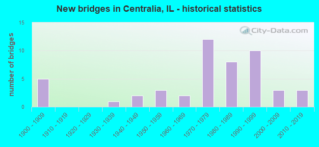
- New bridges - historical statistics
- 51900-1909
- 11930-1939
- 21940-1949
- 31950-1959
- 21960-1969
- 121970-1979
- 81980-1989
- 101990-1999
- 32000-2009
- 32010-2019
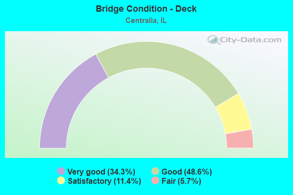
- Bridge Condition - Deck
- 34.3%Very good
- 48.6%Good
- 11.4%Satisfactory
- 5.7%Fair
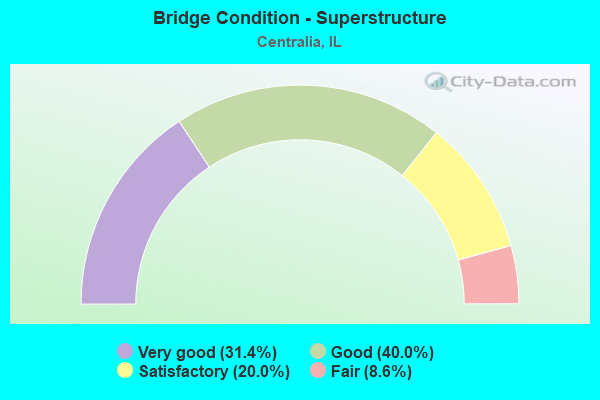
- Bridge Condition - Superstructure
- 31.4%Very good
- 40.0%Good
- 20.0%Satisfactory
- 8.6%Fair
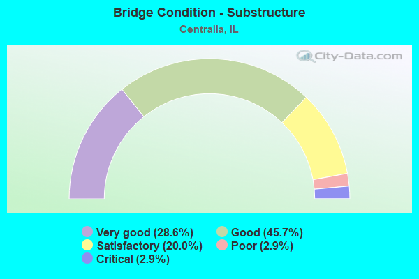
- Bridge Condition - Substructure
- 28.6%Very good
- 45.7%Good
- 20.0%Satisfactory
- 2.9%Poor
- 2.9%Critical
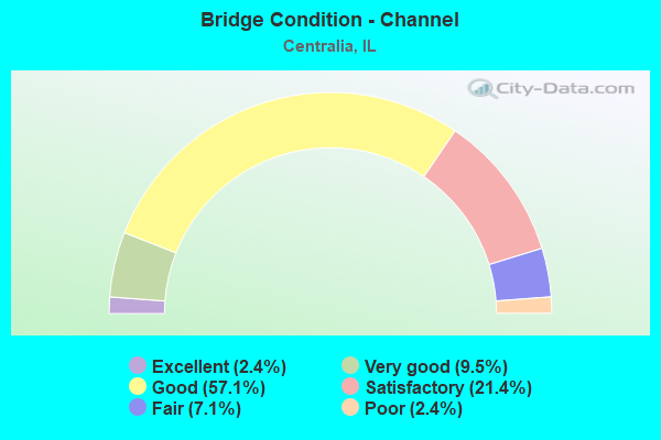
- Bridge Condition - Channel
- 2.4%Excellent
- 9.5%Very good
- 57.1%Good
- 21.4%Satisfactory
- 7.1%Fair
- 2.4%Poor
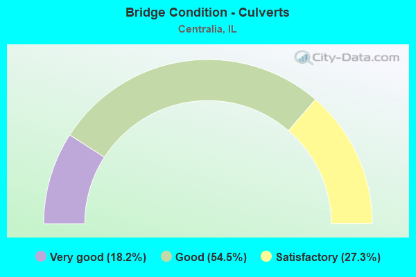
- Bridge Condition - Culverts
- 18.2%Very good
- 54.5%Good
- 27.3%Satisfactory
Find on map >> Show street view
Structure Number: 95313, Location: 5 MI NW OFIRVINGTON (Lat: 38.496647, Lng: -89.218258), Route carried "on" structure: County highway , Year Built: 1978, Status: Open, Structure Length: 2.04m (6.69ft), Average Daily Traffic: 50 (year 2019), Truck Traffic: 16%, Average Future Daily Traffic: 81 (year 2032), Design Load: HS 20, Features Intersected: GRAND POINT CREEK, Facility Carried by Structure: TR 0001
Minimum Vertical Clearance: 30+ m (98+ ft), Kilometerpoint: 2.720, Lanes on structure: 2, Owner: Town or Township Highway Agency, Approaching Roadway Width: 4.3m (14.1ft), Skew: 1 degrees, Material/Design: Concrete, Design/Construction: Channel Beam, Number Of Spans In Main Unit: 2, Length of Maximum Span: 11.0m (36.1ft), Curb-To-Curb Width: 6.9m (22.6ft), Out-to-Out Width: 6.9m (22.6ft)
Condition: Deck: Good, Superstructure: Good, Substructure: Good, Channel: Satisfactory, Operating Rating: 44.1 metric tons, Method Used To Determine Operating Rating: Assigned rating based on Load Factor Design (LFD) reported by rating factor (RF) using MS18 loading, Inventory Rating: 32.4 metric tons, Method Used To Determine Inventory Rating: Assigned rating based on Load Factor Design (LFD) reported by rating factor (RF) using MS18 loading, Structural Evaluation: Better than present minimum criteria, Deck Geometry: Somewhat better than minimum adequacy, Waterway Adequacy: Somewhat better than minimum adequacy, Approach Roadway Alignment: Equal to present minimum criteria, Designated Inspection Frequency: Every 48 months, Inspection Date: March 2020, Deck Structure Type: Concrete Precast Panels, Wearing Surface/Protective System: Wearing Surface: Gravel
Find on map >> Show street view
Structure Number: 953205, Location: 0.7 MI N OF NOLTINGS (Lat: 38.496142, Lng: -89.199869), Route carried "on" structure: County highway , Year Built: 1992, Status: Open, Structure Length: 1.87m (6.14ft), Average Daily Traffic: 550 (year 2019), Truck Traffic: 6%, Average Future Daily Traffic: 376 (year 2032), Design Load: HS 20, Features Intersected: SEWER CREEK, Facility Carried by Structure: CH 18
Minimum Vertical Clearance: 30+ m (98+ ft), Kilometerpoint: 1.046, Lanes on structure: 2, Owner: County Highway Agency, Approaching Roadway Width: 7.3m (24.0ft), Material/Design: Prestressed concrete, Design/Construction: Box Beam or Girders - Multiple, Number Of Spans In Main Unit: 1, Length of Maximum Span: 18.0m (59.1ft), Curb-To-Curb Width: 8.5m (27.9ft), Out-to-Out Width: 8.5m (27.9ft)
Condition: Deck: Satisfactory, Superstructure: Satisfactory, Substructure: Good, Channel: Good, Operating Rating: 44.1 metric tons, Method Used To Determine Operating Rating: Assigned rating based on Load Factor Design (LFD) reported by rating factor (RF) using MS18 loading, Inventory Rating: 32.4 metric tons, Method Used To Determine Inventory Rating: Assigned rating based on Load Factor Design (LFD) reported by rating factor (RF) using MS18 loading, Structural Evaluation: Equal to present minimum criteria, Deck Geometry: Somewhat better than minimum adequacy, Waterway Adequacy: Superior to present desirable criteria, Approach Roadway Alignment: Equal to present desirable criteria, Designated Inspection Frequency: Every 24 months, Inspection Date: November 2021, Deck Structure Type: Concrete Precast Panels, Wearing Surface/Protective System: Wearing Surface: Bituminous
Find on map >> Show street view
Structure Number: 953215, Location: 0.5 MI N OF NOLTINGS (Lat: 38.492722, Lng: -89.199875), Route carried "on" structure: County highway , Year Built: 1992, Status: Open, Structure Length: 1.87m (6.14ft), Average Daily Traffic: 525 (year 2019), Truck Traffic: 7%, Average Future Daily Traffic: 349 (year 2032), Design Load: HS 20, Features Intersected: WEBSTER CREEK, Facility Carried by Structure: CH 18
Minimum Vertical Clearance: 30+ m (98+ ft), Kilometerpoint: 1.416, Lanes on structure: 2, Owner: County Highway Agency, Approaching Roadway Width: 7.3m (24.0ft), Material/Design: Prestressed concrete, Design/Construction: Box Beam or Girders - Multiple, Number Of Spans In Main Unit: 1, Length of Maximum Span: 18.0m (59.1ft), Curb-To-Curb Width: 8.5m (27.9ft), Out-to-Out Width: 8.5m (27.9ft)
Condition: Deck: Good, Superstructure: Good, Substructure: Very good, Channel: Good, Operating Rating: 44.1 metric tons, Method Used To Determine Operating Rating: Assigned rating based on Load Factor Design (LFD) reported by rating factor (RF) using MS18 loading, Inventory Rating: 32.4 metric tons, Method Used To Determine Inventory Rating: Assigned rating based on Load Factor Design (LFD) reported by rating factor (RF) using MS18 loading, Structural Evaluation: Better than present minimum criteria, Deck Geometry: Somewhat better than minimum adequacy, Waterway Adequacy: Equal to present desirable criteria, Approach Roadway Alignment: Equal to present desirable criteria, Designated Inspection Frequency: Every 48 months, Inspection Date: June 2020, Deck Structure Type: Concrete Precast Panels, Wearing Surface/Protective System: Wearing Surface: Bituminous
Find on map >> Show street view
Structure Number: 953228, Location: NORTH OF NOLTINGS (Lat: 38.493444, Lng: -89.199872), Route carried "on" structure: County highway , Year Built: 1994, Status: Open, Structure Length: 1.87m (6.14ft), Average Daily Traffic: 525 (year 2019), Truck Traffic: 7%, Average Future Daily Traffic: 349 (year 2032), Design Load: HS 20, Features Intersected: WEBSTER CK OVERFLOW, Facility Carried by Structure: CH 18
Minimum Vertical Clearance: 30+ m (98+ ft), Kilometerpoint: 1.336, Lanes on structure: 2, Owner: County Highway Agency, Approaching Roadway Width: 7.3m (24.0ft), Material/Design: Prestressed concrete, Design/Construction: Box Beam or Girders - Multiple, Number Of Spans In Main Unit: 1, Length of Maximum Span: 18.0m (59.1ft), Curb-To-Curb Width: 8.5m (27.9ft), Out-to-Out Width: 8.5m (27.9ft)
Condition: Deck: Very good, Superstructure: Very good, Substructure: Very good, Channel: Good, Operating Rating: 44.1 metric tons, Method Used To Determine Operating Rating: Assigned rating based on Load Factor Design (LFD) reported by rating factor (RF) using MS18 loading, Inventory Rating: 32.4 metric tons, Method Used To Determine Inventory Rating: Assigned rating based on Load Factor Design (LFD) reported by rating factor (RF) using MS18 loading, Structural Evaluation: Equal to present desirable criteria, Deck Geometry: Somewhat better than minimum adequacy, Waterway Adequacy: Equal to present desirable criteria, Approach Roadway Alignment: Equal to present desirable criteria, Designated Inspection Frequency: Every 48 months, Inspection Date: June 2020, Deck Structure Type: Concrete Precast Panels, Wearing Surface/Protective System: Wearing Surface: Bituminous
Find on map >> Show street view
Structure Number: 953229, Location: NORTH OF NOLTINGS (Lat: 38.496453, Lng: -89.199869), Route carried "on" structure: County highway , Year Built: 1994, Status: Open, Structure Length: 1.57m (5.15ft), Average Daily Traffic: 550 (year 2019), Truck Traffic: 6%, Average Future Daily Traffic: 376 (year 2032), Design Load: HS 20, Features Intersected: SEWER CREEK OVERFLOW, Facility Carried by Structure: CH 18
Minimum Vertical Clearance: 30+ m (98+ ft), Kilometerpoint: 1.014, Lanes on structure: 2, Owner: County Highway Agency, Approaching Roadway Width: 7.3m (24.0ft), Material/Design: Prestressed concrete, Design/Construction: Box Beam or Girders - Multiple, Number Of Spans In Main Unit: 1, Length of Maximum Span: 14.9m (48.9ft), Curb-To-Curb Width: 8.5m (27.9ft), Out-to-Out Width: 8.5m (27.9ft)
Condition: Deck: Good, Superstructure: Good, Substructure: Good, Channel: Very good, Operating Rating: 44.1 metric tons, Method Used To Determine Operating Rating: Assigned rating based on Load Factor Design (LFD) reported by rating factor (RF) using MS18 loading, Inventory Rating: 32.4 metric tons, Method Used To Determine Inventory Rating: Assigned rating based on Load Factor Design (LFD) reported by rating factor (RF) using MS18 loading, Structural Evaluation: Better than present minimum criteria, Deck Geometry: Somewhat better than minimum adequacy, Waterway Adequacy: Superior to present desirable criteria, Approach Roadway Alignment: Equal to present desirable criteria, Designated Inspection Frequency: Every 48 months, Inspection Date: June 2020, Deck Structure Type: Concrete Precast Panels, Wearing Surface/Protective System: Wearing Surface: Bituminous
Find on map >> Show street view
Structure Number: 610079, Location: MCCORD ST CENTRALIA (Lat: 38.530839, Lng: -89.137208), Route carried "under" structure: City street , Year Built: 1986, Structure Length: 0. m, Average Daily Traffic: 650 (year 2017), Truck Traffic: 8%, Features Intersected: ST-6800 & ICG/BN RR, Facility Carried by Structure: IL 161 WB - FAP 80
Minimum Vertical Clearance: 7.92m (25.98ft), Kilometerpoint: 0.772, Lanes on structure: 3, Lanes under structure: 4, Material/Design: Steel continuous, Design/Construction: Stringer/Multi-beam, Length of Maximum Span: 35.4m (116.1ft)
Find on map >> Show street view
Structure Number: 616003, Location: CENTRALIA (Lat: 38.529192, Lng: -89.135342), Route carried "under" structure: State highway 161, Year Built: 1954, Structure Length: 0. m, Average Daily Traffic: 7,100 (year 2021), Truck Traffic: 5%, Features Intersected: FAP-805 (ILL-161), Facility Carried by Structure: OAK STREET 6900
Minimum Vertical Clearance: 4.42m (14.50ft), Kilometerpoint: 88.528, Lanes on structure: 2, Lanes under structure: 2, Material/Design: Steel, Design/Construction: Stringer/Multi-beam, Length of Maximum Span: 11.9m (39.0ft)
Find on map >> Show street view
Structure Number: 619912, Location: CENTRALIA (Lat: 38.529339, Lng: -89.136156), Route carried "under" structure: State highway 161, Year Built: 1954, Structure Length: 0. m, Average Daily Traffic: 7,100 (year 2021), Truck Traffic: 5%, Features Intersected: FAP-805 (ILL-161), Facility Carried by Structure: SOUTHERN,IC,&CB&Q
Minimum Vertical Clearance: 4.27m (14.01ft), Kilometerpoint: 88.479, Lanes under structure: 2, Material/Design: Steel, Design/Construction: Stringer/Multi-beam, Length of Maximum Span: 11.9m (39.0ft)