Bridge Statistics for Chanute, Kansas (KS)
Condition, Traffic, Stress, Structural Evaluation, Project Costs
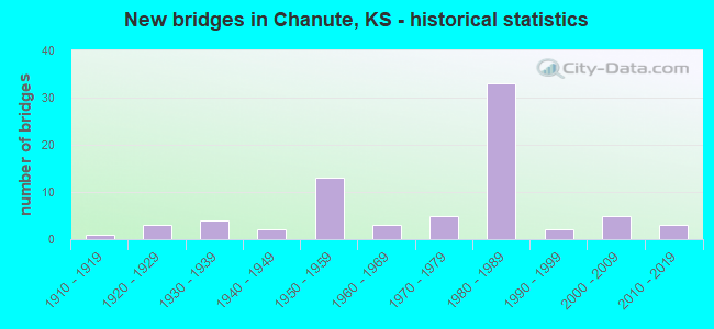
- New bridges - historical statistics
- 11910-1919
- 31920-1929
- 41930-1939
- 21940-1949
- 131950-1959
- 31960-1969
- 51970-1979
- 331980-1989
- 21990-1999
- 52000-2009
- 32010-2019
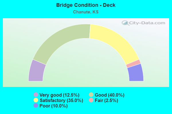
- Bridge Condition - Deck
- 12.5%Very good
- 40.0%Good
- 35.0%Satisfactory
- 2.5%Fair
- 10.0%Poor
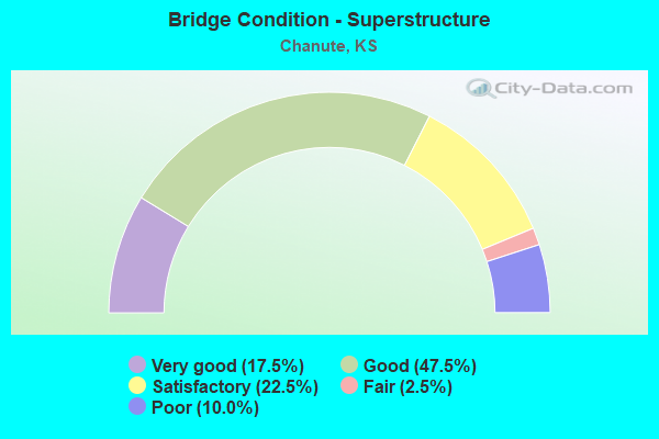
- Bridge Condition - Superstructure
- 17.5%Very good
- 47.5%Good
- 22.5%Satisfactory
- 2.5%Fair
- 10.0%Poor
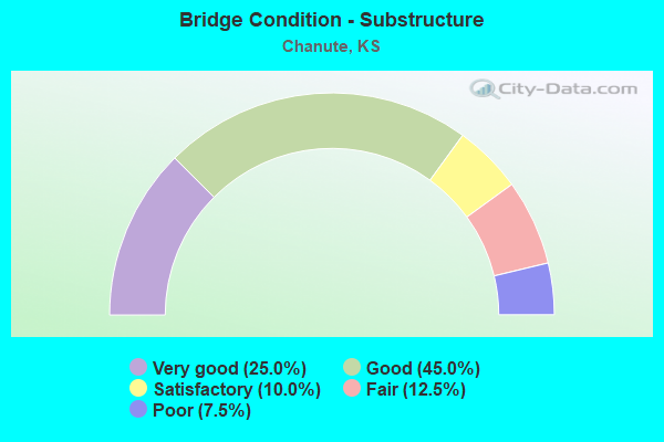
- Bridge Condition - Substructure
- 25.0%Very good
- 45.0%Good
- 10.0%Satisfactory
- 12.5%Fair
- 7.5%Poor
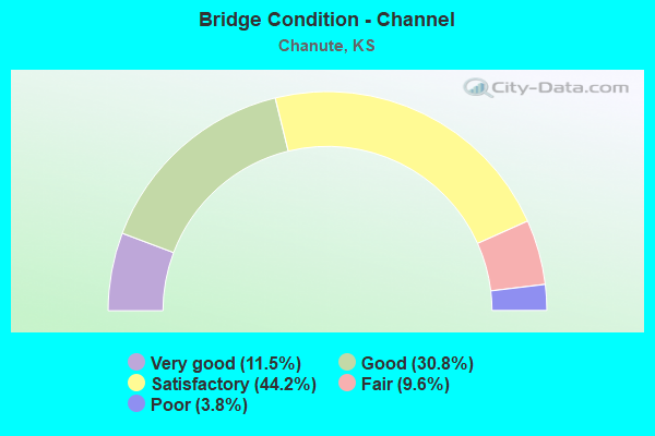
- Bridge Condition - Channel
- 11.5%Very good
- 30.8%Good
- 44.2%Satisfactory
- 9.6%Fair
- 3.8%Poor
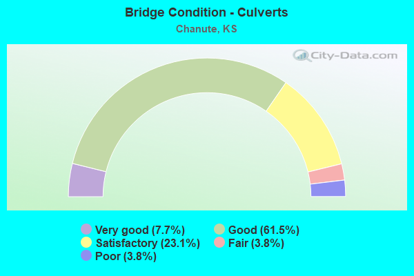
- Bridge Condition - Culverts
- 7.7%Very good
- 61.5%Good
- 23.1%Satisfactory
- 3.8%Fair
- 3.8%Poor
Find on map >> Show street view
Structure Number: 999903900670221, Location: 1.73 MI E WILSON COLN (Lat: 37.689167, Lng: -95.493889), Route carried "on" structure: State highway 39, Year Built: 1958, Status: Open, Structure Length: 0.76m (2.49ft), Average Daily Traffic: 2,948 (year 2020), Truck Traffic: 11%, Average Future Daily Traffic: 3,257 (year 2041), Design Load: H 20, Features Intersected: VILLAGE CREEK DRAINAGE
Minimum Vertical Clearance: 30.47m (99.97ft), Kilometerpoint: 2.791, Lanes on structure: 2, Base Highway Network: Yes, Owner: State Highway Agency, Approaching Roadway Width: 9.1m (29.9ft), Material/Design: Concrete, Design/Construction: Culvert, Number Of Spans In Main Unit: 2, Length of Maximum Span: 3.7m (12.1ft), Curb-To-Curb Width: 12.8m (42.0ft), Out-to-Out Width: 29.7m (97.4ft)
Condition: Channel: Good, Culverts: Good, Operating Rating: 76.2 metric tons, Method Used To Determine Operating Rating: Load Factor (LF), Inventory Rating: 45.6 metric tons, Method Used To Determine Inventory Rating: Load Factor (LF), Structural Evaluation: Better than present minimum criteria, Deck Geometry: Equal to present minimum criteria, Waterway Adequacy: Better than present minimum criteria, Approach Roadway Alignment: Better than present minimum criteria, Length Of Structure Improvement: 2.48m (8.14ft), Designated Inspection Frequency: Every 24 months, Inspection Date: Febuary 2020, Deck Structure Type: Concrete Cast-file-Place, Wearing Surface/Protective System: Wearing Surface: Bituminous
Find on map >> Show street view
Structure Number: 999903900670711, Location: JCT US169/K39 (Lat: 37.689167, Lng: -95.479444), Route carried "on" structure: State highway 39, Year Built: 1984, Status: Open, Structure Length: 6.17m (20.24ft), Average Daily Traffic: 3,430 (year 2020), Truck Traffic: 8%, Average Future Daily Traffic: 3,790 (year 2041), Design Load: HS 20, Features Intersected: US169 HWY, NB & SB
Minimum Vertical Clearance: 30.47m (99.97ft), Kilometerpoint: 4.080, Lanes on structure: 2, Lanes under structure: 4, Owner: State Highway Agency, Approaching Roadway Width: 12.2m (40.0ft), Material/Design: Prestressed concrete continuous, Design/Construction: Stringer/Multi-beam, Number Of Spans In Main Unit: 2, Length of Maximum Span: 30.5m (100.1ft), Curb-To-Curb Width: 12.2m (40.0ft), Out-to-Out Width: 17.8m (58.4ft)
Condition: Deck: Good, Superstructure: Good, Substructure: Good, Operating Rating: 68.0 metric tons, Method Used To Determine Operating Rating: Load Factor (LF), Inventory Rating: 34.5 metric tons, Method Used To Determine Inventory Rating: Load Factor (LF), Structural Evaluation: Better than present minimum criteria, Deck Geometry: Equal to present minimum criteria, Underclear: Better than present minimum criteria, Approach Roadway Alignment: Meets minimum limits, Length Of Structure Improvement: 20.25m (66.44ft), Designated Inspection Frequency: Every 24 months, Inspection Date: Febuary 2020, Deck Structure Type: Concrete Cast-file-Place, Wearing Surface/Protective System: Wearing Surface: Low Slump Concrete
Find on map >> Show street view
Structure Number: 999903900670941, Location: 1.8 MI E SJCT US-169 HWY (Lat: 37.681944, Lng: -95.419444), Route carried "on" structure: State highway 39, Year Built: 2003, Status: Open, Structure Length: 34.40m (112.86ft), Average Daily Traffic: 2,232 (year 2020), Truck Traffic: 12%, Average Future Daily Traffic: 2,466 (year 2041), Design Load: HS 20, Features Intersected: NEOSHO RIVER
Minimum Vertical Clearance: 30.47m (99.97ft), Kilometerpoint: 9.946, Lanes on structure: 2, Base Highway Network: Yes, Owner: State Highway Agency, Approaching Roadway Width: 13.4m (44.0ft), Material/Design: Steel continuous, Design/Construction: Stringer/Multi-beam, Number Of Spans In Main Unit: 6, Length of Maximum Span: 61.0m (200.1ft), Curb-To-Curb Width: 13.4m (44.0ft), Out-to-Out Width: 14.0m (45.9ft)
Condition: Deck: Good, Superstructure: Very good, Substructure: Good, Channel: Good, Inventory Rating: 68.9 metric tons, Method Used To Determine Inventory Rating: Load Factor (LF), Structural Evaluation: Better than present minimum criteria, Deck Geometry: Better than present minimum criteria, Waterway Adequacy: Better than present minimum criteria, Approach Roadway Alignment: Meets minimum limits, Length Of Structure Improvement: 112.86m (370.28ft), Designated Inspection Frequency: Every 24 months, Underwater Inspection Frequency: Every 48 months, Inspection Date: March 2021, Underwater Inspection Date: September 2019, Wearing Surface/Protective System: Wearing Surface: Low Slump Concrete, Deck Protection: Epoxy Coated Reinforcing
Find on map >> Show street view
Structure Number: 999903900670961, Location: 0.22 MI N S JCT K39 (Lat: 37.686111, Lng: -95.451944), Route carried "on" structure: State highway 39, Year Built: 2007, Status: Open, Structure Length: 3.12m (10.24ft), Average Daily Traffic: 5,092 (year 2020), Truck Traffic: 6%, Average Future Daily Traffic: 5,626 (year 2041), Design Load: HS 25 or greater, Features Intersected: SKO RR
Minimum Vertical Clearance: 30.47m (99.97ft), Kilometerpoint: 6.709, Lanes on structure: 2, Owner: State Highway Agency, Approaching Roadway Width: 14.7m (48.2ft), Material/Design: Concrete, Design/Construction: Culvert, Number Of Spans In Main Unit: 1, Length of Maximum Span: 14.6m (47.9ft), Curb or Sidewalk Widths: Left: 1.3m (4.3ft), Right: 1.3m (4.3ft), Curb-To-Curb Width: 14.7m (48.2ft), Out-to-Out Width: 76.2m (250.0ft)
Condition: Culverts: Very good, Operating Rating: 78.9 metric tons, Method Used To Determine Operating Rating: Load Factor (LF), Inventory Rating: 44.5 metric tons, Method Used To Determine Inventory Rating: Load Factor (LF), Structural Evaluation: Equal to present desirable criteria, Deck Geometry: Superior to present desirable criteria, Underclear: Better than present minimum criteria, Approach Roadway Alignment: Equal to present desirable criteria, Length Of Structure Improvement: 12.05m (39.53ft), Designated Inspection Frequency: Every 24 months, Inspection Date: Febuary 2020, Deck Structure Type: Concrete Cast-file-Place, Wearing Surface/Protective System: Wearing Surface: Monolithic Concrete, Deck Protection: Epoxy Coated Reinforcing
Find on map >> Show street view
Structure Number: 999903900670991, Location: 2.285 MI E SJCT US169 (Lat: 37.682500, Lng: -95.443611), Route carried "on" structure: State highway 39, Year Built: 2016, Status: Open, Structure Length: 4.34m (14.24ft), Average Daily Traffic: 2,232 (year 2020), Truck Traffic: 12%, Average Future Daily Traffic: 2,466 (year 2041), Design Load: HL 93, Features Intersected: NEOSHO RIVER DRG
Minimum Vertical Clearance: 30.47m (99.97ft), Kilometerpoint: 7.784, Lanes on structure: 2, Owner: State Highway Agency, Approaching Roadway Width: 13.4m (44.0ft), Material/Design: Concrete continuous, Design/Construction: Slab, Number Of Spans In Main Unit: 4, Length of Maximum Span: 12.2m (40.0ft), Curb-To-Curb Width: 13.4m (44.0ft), Out-to-Out Width: 14.0m (45.9ft)
Condition: Deck: Very good, Superstructure: Very good, Substructure: Very good, Channel: Very good, Operating Rating: 64.2 metric tons, Method Used To Determine Operating Rating: Load and Resistance Factor Rating (LRFR) rating reported by rating factor(RF) method using HL-93 loadings, Inventory Rating: 49.6 metric tons, Method Used To Determine Inventory Rating: Load and Resistance Factor Rating (LRFR) rating reported by rating factor(RF) method using HL-93 loadings, Structural Evaluation: Equal to present desirable criteria, Deck Geometry: Better than present minimum criteria, Waterway Adequacy: Equal to present desirable criteria, Approach Roadway Alignment: Meets minimum limits, Length Of Structure Improvement: 14.25m (46.75ft), Designated Inspection Frequency: Every 24 months, Inspection Date: Febuary 2020, Wearing Surface/Protective System: Wearing Surface: Monolithic Concrete, Deck Protection: Epoxy Coated Reinforcing
Find on map >> Show street view
Structure Number: 999903901030271, Location: 5.74 MI E EJCT US75 (Lat: 37.689167, Lng: -95.547500), Route carried "on" structure: State highway 39, Year Built: 1959, Status: Open, Structure Length: 4.04m (13.25ft), Average Daily Traffic: 1,975 (year 2020), Truck Traffic: 16%, Average Future Daily Traffic: 2,182 (year 2041), Design Load: H 20, Features Intersected: VILLAGE CREEK
Minimum Vertical Clearance: 30.47m (99.97ft), Kilometerpoint: 36.270, Lanes on structure: 2, Base Highway Network: Yes, Owner: State Highway Agency, Approaching Roadway Width: 9.1m (29.9ft), Material/Design: Concrete, Design/Construction: Tee Beam, Number Of Spans In Main Unit: 3, Length of Maximum Span: 15.2m (49.9ft), Curb-To-Curb Width: 8.5m (27.9ft), Out-to-Out Width: 8.9m (29.2ft)
Condition: Deck: Good, Superstructure: Good, Substructure: Good, Channel: Very good, Operating Rating: 42.2 metric tons, Method Used To Determine Operating Rating: Load Factor (LF), Inventory Rating: 26.6 metric tons, Method Used To Determine Inventory Rating: Load Factor (LF), Structural Evaluation: Equal to present minimum criteria, Deck Geometry: Somewhat better than minimum adequacy, Waterway Adequacy: Equal to present minimum criteria, Approach Roadway Alignment: Better than present minimum criteria, Length Of Structure Improvement: 13.25m (43.47ft), Designated Inspection Frequency: Every 24 months, Inspection Date: March 2021, Deck Structure Type: Concrete Cast-file-Place, Wearing Surface/Protective System: Wearing Surface: Low Slump Concrete
Find on map >> Show street view
Structure Number: 999916900010451, Location: NEOSHO - ALLEN CO LINE (Lat: 37.732222, Lng: -95.459722), Route carried "on" structure: US 169, Year Built: 1984, Status: Open, Structure Length: 36.70m (120.41ft), Average Daily Traffic: 4,787 (year 2020), Truck Traffic: 30%, Average Future Daily Traffic: 7,113 (year 2041), Design Load: HS 20, Features Intersected: NEOSHO RIVER &LOCAL RD
Minimum Vertical Clearance: 30.47m (99.97ft), Kilometerpoint: 0.024, Lanes on structure: 2, Lanes under structure: 2, Base Highway Network: Yes, Owner: State Highway Agency, Approaching Roadway Width: 13.4m (44.0ft), Material/Design: Steel continuous, Design/Construction: Stringer/Multi-beam, Number Of Spans In Main Unit: 5, Number Of Approach Spans: 5, Length of Maximum Span: 48.8m (160.1ft), Curb-To-Curb Width: 13.4m (44.0ft), Out-to-Out Width: 14.2m (46.6ft)
Condition: Deck: Good, Superstructure: Good, Substructure: Good, Channel: Satisfactory, Operating Rating: 51.5 metric tons, Method Used To Determine Operating Rating: Load Factor (LF), Inventory Rating: 30.8 metric tons, Method Used To Determine Inventory Rating: Load Factor (LF), Structural Evaluation: Better than present minimum criteria, Deck Geometry: Better than present minimum criteria, Underclear: Equal to present minimum criteria, Waterway Adequacy: Better than present minimum criteria, Approach Roadway Alignment: Equal to present desirable criteria, Length Of Structure Improvement: 120.40m (395.01ft), Designated Inspection Frequency: Every 24 months, Inspection Date: Febuary 2021, Deck Structure Type: Concrete Cast-file-Place, Wearing Surface/Protective System: Wearing Surface: Low Slump Concrete
Find on map >> Show street view
Structure Number: 999916900010461, Location: 1.10 MI N ALLEN CO LINE (Lat: 37.740556, Lng: -95.442222), Route carried "on" structure: US 169, Year Built: 1985, Status: Open, Structure Length: 8.64m (28.35ft), Average Daily Traffic: 4,787 (year 2020), Truck Traffic: 30%, Average Future Daily Traffic: 7,113 (year 2041), Design Load: HS 20, Features Intersected: NEOSHO OVERFLOW
Minimum Vertical Clearance: 30.47m (99.97ft), Kilometerpoint: 1.769, Lanes on structure: 2, Base Highway Network: Yes, Owner: State Highway Agency, Approaching Roadway Width: 13.4m (44.0ft), Material/Design: Prestressed concrete continuous, Design/Construction: Stringer/Multi-beam, Number Of Spans In Main Unit: 4, Length of Maximum Span: 21.5m (70.5ft), Curb-To-Curb Width: 13.4m (44.0ft), Out-to-Out Width: 14.0m (45.9ft)
Condition: Deck: Good, Superstructure: Very good, Substructure: Good, Channel: Good, Operating Rating: 67.1 metric tons, Method Used To Determine Operating Rating: Load Factor (LF), Inventory Rating: 30.8 metric tons, Method Used To Determine Inventory Rating: Load Factor (LF), Structural Evaluation: Better than present minimum criteria, Deck Geometry: Better than present minimum criteria, Waterway Adequacy: Somewhat better than minimum adequacy, Approach Roadway Alignment: Meets minimum limits, Length Of Structure Improvement: 28.34m (92.98ft), Designated Inspection Frequency: Every 24 months, Inspection Date: Febuary 2021, Wearing Surface/Protective System: Wearing Surface: Low Slump Concrete, Deck Protection: Epoxy Coated Reinforcing
Find on map >> Show street view
Structure Number: 999916900010471, Location: 1.31 MI N OF NEOSHO CO LN (Lat: 37.741667, Lng: -95.438611), Route carried "on" structure: County highway 2096, Year Built: 1984, Status: Open, Structure Length: 6.32m (20.73ft), Average Daily Traffic: 2,308 (year 2020), Truck Traffic: 4%, Average Future Daily Traffic: 6,806 (year 2041), Design Load: HS 20, Features Intersected: US169 HWY
Minimum Vertical Clearance: 30.47m (99.97ft), Kilometerpoint: 1.044, Lanes on structure: 2, Lanes under structure: 4, Owner: State Highway Agency, Approaching Roadway Width: 13.4m (44.0ft), Skew: 2 degrees, Material/Design: Prestressed concrete continuous, Design/Construction: Stringer/Multi-beam, Number Of Spans In Main Unit: 3, Length of Maximum Span: 28.7m (94.2ft), Curb-To-Curb Width: 13.4m (44.0ft), Out-to-Out Width: 14.0m (45.9ft)
Condition: Deck: Satisfactory, Superstructure: Very good, Substructure: Good, Operating Rating: 65.3 metric tons, Method Used To Determine Operating Rating: Load Factor (LF), Inventory Rating: 33.6 metric tons, Method Used To Determine Inventory Rating: Load Factor (LF), Structural Evaluation: Better than present minimum criteria, Deck Geometry: Better than present minimum criteria, Underclear: Better than present minimum criteria, Approach Roadway Alignment: Meets minimum limits, Length Of Structure Improvement: 20.72m (67.98ft), Designated Inspection Frequency: Every 24 months, Inspection Date: Febuary 2021, Deck Structure Type: Concrete Cast-file-Place, Wearing Surface/Protective System: Wearing Surface: Low Slump Concrete
Find on map >> Show street view
Structure Number: 999916900010481, Location: 1.79 MI N NEOSHO CO LINE (Lat: 37.743889, Lng: -95.430278), Route carried "on" structure: US 169, Year Built: 1984, Status: Open, Structure Length: 5.17m (16.96ft), Average Daily Traffic: 4,456 (year 2020), Truck Traffic: 32%, Average Future Daily Traffic: 6,621 (year 2041), Design Load: HS 20, Features Intersected: SKO R.R.
Minimum Vertical Clearance: 30.47m (99.97ft), Kilometerpoint: 2.874, Lanes on structure: 2, Base Highway Network: Yes, Owner: State Highway Agency, Approaching Roadway Width: 13.4m (44.0ft), Skew: 1 degrees, Material/Design: Steel continuous, Design/Construction: Stringer/Multi-beam, Number Of Spans In Main Unit: 3, Length of Maximum Span: 19.1m (62.7ft), Curb-To-Curb Width: 13.4m (44.0ft), Out-to-Out Width: 14.0m (45.9ft)
Condition: Deck: Good, Superstructure: Good, Substructure: Very good, Operating Rating: 79.2 metric tons, Method Used To Determine Operating Rating: Load Factor (LF), Inventory Rating: 47.4 metric tons, Method Used To Determine Inventory Rating: Load Factor (LF), Structural Evaluation: Better than present minimum criteria, Deck Geometry: Better than present minimum criteria, Underclear: Better than present minimum criteria, Approach Roadway Alignment: Meets minimum limits, Length Of Structure Improvement: 16.96m (55.64ft), Designated Inspection Frequency: Every 24 months, Inspection Date: Febuary 2021, Deck Structure Type: Concrete Cast-file-Place, Wearing Surface/Protective System: Wearing Surface: Low Slump Concrete
Find on map >> Show street view
Structure Number: 999916900670631, Location: 6.49 MI N K47 (Lat: 37.621111, Lng: -95.479444), Route carried "on" structure: US 169, Year Built: 1984, Status: Open, Structure Length: 3.73m (12.24ft), Average Daily Traffic: 5,886 (year 2020), Truck Traffic: 22%, Average Future Daily Traffic: 8,746 (year 2041), Design Load: HS 20, Features Intersected: TURKEY CREEK
Minimum Vertical Clearance: 30.47m (99.97ft), Kilometerpoint: 27.071, Lanes on structure: 2, Base Highway Network: Yes, Owner: State Highway Agency, Approaching Roadway Width: 13.4m (44.0ft), Material/Design: Concrete continuous, Design/Construction: Slab, Number Of Spans In Main Unit: 3, Length of Maximum Span: 14.6m (47.9ft), Curb-To-Curb Width: 13.4m (44.0ft), Out-to-Out Width: 14.0m (45.9ft)
Condition: Deck: Good, Superstructure: Good, Substructure: Good, Channel: Good, Operating Rating: 63.5 metric tons, Method Used To Determine Operating Rating: Load Factor (LF), Inventory Rating: 38.1 metric tons, Method Used To Determine Inventory Rating: Load Factor (LF), Structural Evaluation: Better than present minimum criteria, Deck Geometry: Equal to present minimum criteria, Waterway Adequacy: Better than present minimum criteria, Approach Roadway Alignment: Equal to present desirable criteria, Length Of Structure Improvement: 12.25m (40.19ft), Designated Inspection Frequency: Every 24 months, Inspection Date: Febuary 2020, Deck Structure Type: Concrete Cast-file-Place, Wearing Surface/Protective System: Wearing Surface: Low Slump Concrete
Find on map >> Show street view
Structure Number: 999916900670641, Location: 8.16 MI N K47 (Lat: 37.645556, Lng: -95.479444), Route carried "on" structure: County highway 420, Year Built: 1984, Status: Open, Structure Length: 6.11m (20.05ft), Average Daily Traffic: 2,733 (year 2020), Truck Traffic: 7%, Average Future Daily Traffic: 4,061 (year 2041), Design Load: HS 20, Features Intersected: US169 HWY, Facility Carried by Structure: 35TH STREET
Minimum Vertical Clearance: 30.47m (99.97ft), Kilometerpoint: 0.861, Lanes on structure: 2, Lanes under structure: 2, Owner: State Highway Agency, Approaching Roadway Width: 7.3m (24.0ft), Material/Design: Prestressed concrete continuous, Design/Construction: Stringer/Multi-beam, Number Of Spans In Main Unit: 3, Length of Maximum Span: 26.8m (87.9ft), Curb-To-Curb Width: 13.4m (44.0ft), Out-to-Out Width: 14.0m (45.9ft)
Condition: Deck: Good, Superstructure: Good, Substructure: Very good, Operating Rating: 77.1 metric tons, Method Used To Determine Operating Rating: Load Factor (LF), Inventory Rating: 44.5 metric tons, Method Used To Determine Inventory Rating: Load Factor (LF), Structural Evaluation: Better than present minimum criteria, Deck Geometry: Better than present minimum criteria, Underclear: Better than present minimum criteria, Approach Roadway Alignment: Meets minimum limits, Length Of Structure Improvement: 20.05m (65.78ft), Designated Inspection Frequency: Every 24 months, Inspection Date: Febuary 2020, Deck Structure Type: Concrete Cast-file-Place, Wearing Surface/Protective System: Wearing Surface: Low Slump Concrete
Find on map >> Show street view
Structure Number: 999916900670651, Location: 8.72 MI N K47 (Lat: 37.653611, Lng: -95.479444), Route carried "on" structure: US 169, Year Built: 1982, Status: Open, Structure Length: 0.77m (2.53ft), Average Daily Traffic: 5,130 (year 2020), Truck Traffic: 24%, Average Future Daily Traffic: 7,623 (year 2041), Design Load: H 20, Features Intersected: LITTLE TURKEY CREEK
Minimum Vertical Clearance: 30.47m (99.97ft), Kilometerpoint: 30.660, Lanes on structure: 2, Base Highway Network: Yes, Owner: State Highway Agency, Approaching Roadway Width: 13.4m (44.0ft), Material/Design: Concrete, Design/Construction: Culvert, Number Of Spans In Main Unit: 3, Length of Maximum Span: 2.4m (7.9ft), Curb-To-Curb Width: 13.4m (44.0ft), Out-to-Out Width: 28.7m (94.2ft)
Condition: Channel: Satisfactory, Culverts: Fair, Operating Rating: 49.3 metric tons, Method Used To Determine Operating Rating: Load Factor (LF), Inventory Rating: 29.5 metric tons, Method Used To Determine Inventory Rating: Load Factor (LF), Structural Evaluation: Somewhat better than minimum adequacy, Deck Geometry: Equal to present minimum criteria, Waterway Adequacy: Equal to present minimum criteria, Approach Roadway Alignment: Equal to present desirable criteria, Length Of Structure Improvement: 2.53m (8.30ft), Designated Inspection Frequency: Every 24 months, Inspection Date: Febuary 2020, Deck Structure Type: Concrete Cast-file-Place, Wearing Surface/Protective System: Wearing Surface: Monolithic Concrete
Find on map >> Show street view
Structure Number: 999916900670661, Location: 9.15 MI N K47 (Lat: 37.659722, Lng: -95.479444), Route carried "on" structure: County highway 400, Year Built: 1983, Status: Open, Structure Length: 7.45m (24.44ft), Average Daily Traffic: 1,178 (year 2020), Truck Traffic: 4%, Average Future Daily Traffic: 1,750 (year 2041), Design Load: HS 20, Features Intersected: US169 HWY NB/ SB
Minimum Vertical Clearance: 30.47m (99.97ft), Kilometerpoint: 0.859, Lanes on structure: 2, Lanes under structure: 4, Owner: State Highway Agency, Approaching Roadway Width: 7.3m (24.0ft), Material/Design: Prestressed concrete continuous, Design/Construction: Stringer/Multi-beam, Number Of Spans In Main Unit: 4, Length of Maximum Span: 20.7m (67.9ft), Curb-To-Curb Width: 13.4m (44.0ft), Out-to-Out Width: 14.0m (45.9ft)
Condition: Deck: Very good, Superstructure: Good, Substructure: Good, Operating Rating: 68.0 metric tons, Method Used To Determine Operating Rating: Load Factor (LF), Inventory Rating: 37.2 metric tons, Method Used To Determine Inventory Rating: Load Factor (LF), Structural Evaluation: Better than present minimum criteria, Deck Geometry: Equal to present desirable criteria, Underclear: Superior to present desirable criteria, Approach Roadway Alignment: Somewhat better than minimum adequacy, Length Of Structure Improvement: 24.45m (80.22ft), Designated Inspection Frequency: Every 24 months, Inspection Date: Febuary 2020, Deck Structure Type: Concrete Cast-file-Place, Wearing Surface/Protective System: Wearing Surface: Low Slump Concrete
Find on map >> Show street view
Structure Number: 999916900670681, Location: 0.99 MI S K-39 (Lat: 37.674722, Lng: -95.479444), Route carried "on" structure: City street 406, Year Built: 1984, Status: Open, Structure Length: 6.17m (20.24ft), Average Daily Traffic: 1,892 (year 2020), Truck Traffic: 4%, Average Future Daily Traffic: 2,175 (year 2041), Design Load: HS 20, Features Intersected: US169 HWY, NB-SB
Minimum Vertical Clearance: 30.47m (99.97ft), Kilometerpoint: 0.861, Lanes on structure: 2, Lanes under structure: 4, Owner: State Highway Agency, Approaching Roadway Width: 7.3m (24.0ft), Material/Design: Prestressed concrete continuous, Design/Construction: Stringer/Multi-beam, Number Of Spans In Main Unit: 2, Length of Maximum Span: 30.5m (100.1ft), Curb or Sidewalk Widths: Left: 1.5m (4.9ft), Right: 0.0m, Curb-To-Curb Width: 14.6m (47.9ft), Out-to-Out Width: 16.9m (55.4ft)
Condition: Deck: Very good, Superstructure: Good, Substructure: Very good, Operating Rating: 73.5 metric tons, Method Used To Determine Operating Rating: Load Factor (LF), Inventory Rating: 41.7 metric tons, Method Used To Determine Inventory Rating: Load Factor (LF), Structural Evaluation: Better than present minimum criteria, Deck Geometry: Superior to present desirable criteria, Underclear: Superior to present desirable criteria, Approach Roadway Alignment: Meets minimum limits, Length Of Structure Improvement: 20.25m (66.44ft), Designated Inspection Frequency: Every 24 months, Inspection Date: Febuary 2020, Deck Structure Type: Concrete Cast-file-Place, Wearing Surface/Protective System: Wearing Surface: Low Slump Concrete
Find on map >> Show street view
Structure Number: 999916900670691, Location: 10.67 MI N K47 (Lat: 37.681944, Lng: -95.479444), Route carried "on" structure: County highway 412, Year Built: 1984, Status: Open, Structure Length: 6.17m (20.24ft), Average Daily Traffic: 404 (year 2020), Truck Traffic: 4%, Average Future Daily Traffic: 305 (year 2041), Design Load: HS 20, Features Intersected: US169 HWY, NB-SB, Facility Carried by Structure: MAIN STREET
Minimum Vertical Clearance: 30.47m (99.97ft), Kilometerpoint: 0.847, Lanes on structure: 2, Lanes under structure: 4, Owner: State Highway Agency, Approaching Roadway Width: 7.3m (24.0ft), Material/Design: Prestressed concrete continuous, Design/Construction: Stringer/Multi-beam, Number Of Spans In Main Unit: 2, Length of Maximum Span: 30.5m (100.1ft), Curb or Sidewalk Widths: Left: 0.0m, Right: 1.5m (4.9ft), Curb-To-Curb Width: 14.6m (47.9ft), Out-to-Out Width: 16.9m (55.4ft)
Condition: Deck: Good, Superstructure: Good, Substructure: Good, Operating Rating: 73.5 metric tons, Method Used To Determine Operating Rating: Load Factor (LF), Inventory Rating: 41.7 metric tons, Method Used To Determine Inventory Rating: Load Factor (LF), Structural Evaluation: Better than present minimum criteria, Deck Geometry: Superior to present desirable criteria, Underclear: Superior to present desirable criteria, Approach Roadway Alignment: Somewhat better than minimum adequacy, Length Of Structure Improvement: 20.25m (66.44ft), Designated Inspection Frequency: Every 24 months, Inspection Date: Febuary 2020, Deck Structure Type: Concrete Cast-file-Place, Wearing Surface/Protective System: Wearing Surface: Low Slump Concrete
Find on map >> Show street view
Structure Number: 999916900670701, Location: US169/K39,E BD RAMP (Lat: 37.687500, Lng: -95.478889), Route carried "on" structure: Ramp State highway 2, Year Built: 1983, Status: Open, Structure Length: 0.88m (2.89ft), Average Daily Traffic: 785 (year 2020), Average Future Daily Traffic: 3,351 (year 2041), Design Load: H 20, Features Intersected: DRAINAGE, Facility Carried by Structure: US169 RAMP RIGHT
Minimum Vertical Clearance: 30.47m (99.97ft), Kilometerpoint: 0.177, Lanes on structure: 1, Base Highway Network: Yes (Inventory Route: 6740002, Subroute: 1), Owner: State Highway Agency, Approaching Roadway Width: 7.3m (24.0ft), Skew: 3 degrees, Material/Design: Concrete, Design/Construction: Culvert, Number Of Spans In Main Unit: 3, Length of Maximum Span: 2.4m (7.9ft), Curb-To-Curb Width: 7.3m (24.0ft), Out-to-Out Width: 40.4m (132.5ft)
Condition: Channel: Good, Culverts: Good, Operating Rating: 40.9 metric tons, Method Used To Determine Operating Rating: Load Factor (LF), Inventory Rating: 24.5 metric tons, Method Used To Determine Inventory Rating: Load Factor (LF), Structural Evaluation: Equal to present minimum criteria, Deck Geometry: Better than present minimum criteria, Waterway Adequacy: Equal to present desirable criteria, Approach Roadway Alignment: Somewhat better than minimum adequacy, Length Of Structure Improvement: 2.89m (9.48ft), Designated Inspection Frequency: Every 24 months, Inspection Date: Febuary 2020, Deck Structure Type: Concrete Cast-file-Place, Wearing Surface/Protective System: Wearing Surface: Monolithic Concrete
Find on map >> Show street view
Structure Number: 999916900670721, Location: 0.37 MI N K39 (Lat: 37.693889, Lng: -95.479167), Route carried "on" structure: US 169, Year Built: 1983, Status: Open, Structure Length: 0.63m (2.07ft), Average Daily Traffic: 4,284 (year 2020), Truck Traffic: 32%, Average Future Daily Traffic: 6,366 (year 2041), Design Load: H 20, Features Intersected: VILLAGE CR DRAINAGE
Minimum Vertical Clearance: 30.47m (99.97ft), Kilometerpoint: 35.166, Lanes on structure: 4, Base Highway Network: Yes, Owner: State Highway Agency, Approaching Roadway Width: 13.4m (44.0ft), Skew: 34 degrees, Material/Design: Concrete, Design/Construction: Culvert, Number Of Spans In Main Unit: 2, Length of Maximum Span: 2.1m (6.9ft), Curb-To-Curb Width: 20.1m (65.9ft), Out-to-Out Width: 64.0m (210.0ft)
Condition: Channel: Good, Culverts: Good, Operating Rating: 89.8 metric tons, Method Used To Determine Operating Rating: Load Factor (LF), Inventory Rating: 89.8 metric tons, Method Used To Determine Inventory Rating: Load Factor (LF), Structural Evaluation: Better than present minimum criteria, Deck Geometry: Better than present minimum criteria, Waterway Adequacy: Equal to present desirable criteria, Approach Roadway Alignment: Equal to present desirable criteria, Length Of Structure Improvement: 2.05m (6.73ft), Designated Inspection Frequency: Every 24 months, Inspection Date: Febuary 2020, Deck Structure Type: Concrete Cast-file-Place, Wearing Surface/Protective System: Wearing Surface: Monolithic Concrete
Find on map >> Show street view
Structure Number: 999916900670731, Location: 0.60 MI N K39 (Lat: 37.697778, Lng: -95.479167), Route carried "on" structure: US 169, Year Built: 1984, Status: Open, Structure Length: 4.05m (13.29ft), Average Daily Traffic: 4,284 (year 2020), Truck Traffic: 32%, Average Future Daily Traffic: 6,366 (year 2041), Design Load: HS 20, Features Intersected: HAUL ROAD
Minimum Vertical Clearance: 30.47m (99.97ft), Kilometerpoint: 35.558, Lanes on structure: 2, Lanes under structure: 2, Base Highway Network: Yes, Owner: State Highway Agency, Approaching Roadway Width: 13.4m (44.0ft), Skew: 2 degrees, Material/Design: Concrete continuous, Design/Construction: Slab, Number Of Spans In Main Unit: 3, Length of Maximum Span: 15.8m (51.8ft), Curb-To-Curb Width: 13.4m (44.0ft), Out-to-Out Width: 14.0m (45.9ft)
Condition: Deck: Good, Superstructure: Good, Substructure: Good, Operating Rating: 83.5 metric tons, Method Used To Determine Operating Rating: Load Factor (LF), Inventory Rating: 49.9 metric tons, Method Used To Determine Inventory Rating: Load Factor (LF), Structural Evaluation: Better than present minimum criteria, Deck Geometry: Better than present minimum criteria, Underclear: Meets minimum limits, Approach Roadway Alignment: Meets minimum limits, Length Of Structure Improvement: 13.28m (43.57ft), Designated Inspection Frequency: Every 24 months, Inspection Date: Febuary 2020, Deck Structure Type: Concrete Cast-file-Place, Wearing Surface/Protective System: Wearing Surface: Low Slump Concrete
Find on map >> Show street view
Structure Number: 999916900670741, Location: 0.76 MI N JCT US169&K39 (Lat: 37.700000, Lng: -95.479167), Route carried "on" structure: US 169, Year Built: 1984, Status: Open, Structure Length: 7.34m (24.08ft), Average Daily Traffic: 4,284 (year 2020), Truck Traffic: 32%, Average Future Daily Traffic: 6,366 (year 2041), Design Load: HS 20, Features Intersected: VILLAGE CREEK
Minimum Vertical Clearance: 30.47m (99.97ft), Kilometerpoint: 35.813, Lanes on structure: 2, Base Highway Network: Yes, Owner: State Highway Agency, Approaching Roadway Width: 13.4m (44.0ft), Skew: 3 degrees, Material/Design: Prestressed concrete continuous, Design/Construction: Stringer/Multi-beam, Number Of Spans In Main Unit: 3, Length of Maximum Span: 24.1m (79.1ft), Curb-To-Curb Width: 13.4m (44.0ft), Out-to-Out Width: 14.0m (45.9ft)
Condition: Deck: Good, Superstructure: Very good, Substructure: Very good, Channel: Good, Operating Rating: 68.9 metric tons, Method Used To Determine Operating Rating: Load Factor (LF), Inventory Rating: 37.2 metric tons, Method Used To Determine Inventory Rating: Load Factor (LF), Structural Evaluation: Equal to present desirable criteria, Deck Geometry: Better than present minimum criteria, Waterway Adequacy: Better than present minimum criteria, Approach Roadway Alignment: Equal to present desirable criteria, Length Of Structure Improvement: 24.08m (79.00ft), Designated Inspection Frequency: Every 24 months, Inspection Date: Febuary 2020, Deck Structure Type: Concrete Cast-file-Place, Wearing Surface/Protective System: Wearing Surface: Low Slump Concrete
Find on map >> Show street view
Structure Number: 999916900670751, Location: 1.00 MI N-JCT K39&U169 (Lat: 37.703611, Lng: -95.479167), Route carried "on" structure: US 169, Year Built: 1984, Status: Open, Structure Length: 3.73m (12.24ft), Average Daily Traffic: 4,284 (year 2020), Truck Traffic: 32%, Average Future Daily Traffic: 6,366 (year 2041), Design Load: HS 20, Features Intersected: LOCAL RD
Minimum Vertical Clearance: 30.47m (99.97ft), Kilometerpoint: 36.194, Lanes on structure: 2, Lanes under structure: 2, Base Highway Network: Yes, Owner: State Highway Agency, Approaching Roadway Width: 13.4m (44.0ft), Material/Design: Concrete continuous, Design/Construction: Slab, Number Of Spans In Main Unit: 3, Length of Maximum Span: 14.6m (47.9ft), Curb-To-Curb Width: 13.4m (44.0ft), Out-to-Out Width: 14.0m (45.9ft)
Condition: Deck: Good, Superstructure: Good, Substructure: Very good, Operating Rating: 63.5 metric tons, Method Used To Determine Operating Rating: Load Factor (LF), Inventory Rating: 38.1 metric tons, Method Used To Determine Inventory Rating: Load Factor (LF), Structural Evaluation: Better than present minimum criteria, Deck Geometry: Better than present minimum criteria, Underclear: Equal to present minimum criteria, Approach Roadway Alignment: Equal to present desirable criteria, Length Of Structure Improvement: 12.25m (40.19ft), Designated Inspection Frequency: Every 24 months, Inspection Date: Febuary 2020, Deck Structure Type: Concrete Cast-file-Place, Wearing Surface/Protective System: Wearing Surface: Low Slump Concrete
Find on map >> Show street view
Structure Number: 999916900670761, Location: 2.68 MI N JCT K39 (Lat: 37.725556, Lng: -95.470833), Route carried "on" structure: County highway 1332, Year Built: 1984, Status: Open, Structure Length: 7.37m (24.18ft), Average Daily Traffic: 574 (year 2020), Truck Traffic: 5%, Average Future Daily Traffic: 7,311 (year 2041), Design Load: HS 20, Features Intersected: US169 HIGHWAY, Facility Carried by Structure: RS0001
Minimum Vertical Clearance: 30.47m (99.97ft), Kilometerpoint: 1.770, Lanes on structure: 2, Lanes under structure: 2, Owner: State Highway Agency, Approaching Roadway Width: 7.3m (24.0ft), Skew: 3 degrees, Material/Design: Prestressed concrete continuous, Design/Construction: Stringer/Multi-beam, Number Of Spans In Main Unit: 3, Length of Maximum Span: 33.5m (109.9ft), Curb-To-Curb Width: 13.4m (44.0ft), Out-to-Out Width: 14.0m (45.9ft)
Condition: Deck: Good, Superstructure: Good, Substructure: Good, Operating Rating: 72.6 metric tons, Method Used To Determine Operating Rating: Load Factor (LF), Inventory Rating: 40.8 metric tons, Method Used To Determine Inventory Rating: Load Factor (LF), Structural Evaluation: Better than present minimum criteria, Deck Geometry: Superior to present desirable criteria, Underclear: Better than present minimum criteria, Approach Roadway Alignment: Somewhat better than minimum adequacy, Length Of Structure Improvement: 24.18m (79.33ft), Designated Inspection Frequency: Every 24 months, Inspection Date: Febuary 2020, Deck Structure Type: Concrete Cast-file-Place, Wearing Surface/Protective System: Wearing Surface: Low Slump Concrete
Find on map >> Show street view
Structure Number: 999903900670711, Location: JCT US169/K39 (Lat: 37.689167, Lng: -95.479444), Route carried "under" structure: US 169, Year Built: 1984, Structure Length: 0. m, Average Daily Traffic: 2,142 (year 2020), Truck Traffic: 32%, Features Intersected: US169 HWY, NB & SB, Facility Carried by Structure: K39 HWY
Minimum Vertical Clearance: 4.96m (16.27ft), Kilometerpoint: 34.586, Lanes on structure: 2, Lanes under structure: 4, Material/Design: Prestressed concrete continuous, Design/Construction: Stringer/Multi-beam, Length of Maximum Span: 30.5m (100.1ft)
Find on map >> Show street view
Structure Number: 999916900010471, Location: 1.31 MI N OF NEOSHO CO LN (Lat: 37.741667, Lng: -95.438611), Route carried "under" structure: US 169, Year Built: 1984, Structure Length: 0. m, Average Daily Traffic: 4,456 (year 2020), Truck Traffic: 32%, Features Intersected: US169 HWY, Facility Carried by Structure: RS2096
Minimum Vertical Clearance: 4.98m (16.34ft), Kilometerpoint: 2.103, Lanes on structure: 2, Lanes under structure: 4, Material/Design: Prestressed concrete continuous, Design/Construction: Stringer/Multi-beam, Length of Maximum Span: 28.7m (94.2ft)
Find on map >> Show street view
Structure Number: 999916900670641, Location: 8.16 MI N K47 (Lat: 37.645556, Lng: -95.479444), Route carried "under" structure: US 169, Year Built: 1984, Structure Length: 0. m, Average Daily Traffic: 5,130 (year 2020), Truck Traffic: 24%, Features Intersected: US169 HWY, Facility Carried by Structure: 35TH STREET
Minimum Vertical Clearance: 5.14m (16.86ft), Kilometerpoint: 29.763, Lanes on structure: 2, Lanes under structure: 2, Material/Design: Prestressed concrete continuous, Design/Construction: Stringer/Multi-beam, Length of Maximum Span: 26.8m (87.9ft)
Find on map >> Show street view
Structure Number: 999916900670661, Location: 9.15 MI N K47 (Lat: 37.659722, Lng: -95.479444), Route carried "under" structure: US 169, Year Built: 1983, Structure Length: 0. m, Average Daily Traffic: 2,565 (year 2020), Truck Traffic: 24%, Features Intersected: US169 HWY NB/ SB, Facility Carried by Structure: URB0400/ 21ST ST
Minimum Vertical Clearance: 5.04m (16.54ft), Kilometerpoint: 31.344, Lanes on structure: 2, Lanes under structure: 4, Material/Design: Prestressed concrete continuous, Design/Construction: Stringer/Multi-beam, Length of Maximum Span: 20.7m (67.9ft)
Find on map >> Show street view
Structure Number: 999916900670674, Location: 9.31 MI N JCT US169&K47 (Lat: 37.662222, Lng: -95.479167), Route carried "under" structure: US 169, Year Built: 1985, Structure Length: 0. m, Average Daily Traffic: 2,565 (year 2020), Truck Traffic: 24%, Features Intersected: US169 HWY, Facility Carried by Structure: SKOL RAILWAY
Minimum Vertical Clearance: 5.19m (17.03ft), Kilometerpoint: 31.603, Lanes under structure: 4, Material/Design: Steel continuous, Design/Construction: Stringer/Multi-beam, Length of Maximum Span: 19.5m (64.0ft)
Find on map >> Show street view
Structure Number: 999916900670681, Location: 0.99 MI S K-39 (Lat: 37.674722, Lng: -95.479444), Route carried "under" structure: US 169, Year Built: 1984, Structure Length: 0. m, Average Daily Traffic: 2,565 (year 2020), Truck Traffic: 24%, Features Intersected: US169 HWY, NB-SB, Facility Carried by Structure: URB0406, 7TH ST
Minimum Vertical Clearance: 5.03m (16.50ft), Kilometerpoint: 32.993, Lanes on structure: 2, Lanes under structure: 4, Material/Design: Prestressed concrete continuous, Design/Construction: Stringer/Multi-beam, Length of Maximum Span: 30.5m (100.1ft)
Find on map >> Show street view
Structure Number: 999916900670691, Location: 10.67 MI N K47 (Lat: 37.681944, Lng: -95.479444), Route carried "under" structure: US 169, Year Built: 1984, Structure Length: 0. m, Average Daily Traffic: 2,565 (year 2020), Truck Traffic: 24%, Features Intersected: US169 HWY, NB-SB, Facility Carried by Structure: MAIN STREET
Minimum Vertical Clearance: 5.04m (16.54ft), Kilometerpoint: 33.796, Lanes on structure: 2, Lanes under structure: 4, Material/Design: Prestressed concrete continuous, Design/Construction: Stringer/Multi-beam, Length of Maximum Span: 30.5m (100.1ft)
Find on map >> Show street view
Structure Number: 999916900670761, Location: 2.68 MI N JCT K39 (Lat: 37.725556, Lng: -95.470833), Route carried "under" structure: US 169, Year Built: 1984, Structure Length: 0. m, Average Daily Traffic: 4,787 (year 2020), Truck Traffic: 30%, Features Intersected: US169 HIGHWAY, Facility Carried by Structure: RS0001
Minimum Vertical Clearance: 4.88m (16.01ft), Kilometerpoint: 38.882, Lanes on structure: 2, Lanes under structure: 2, Material/Design: Prestressed concrete continuous, Design/Construction: Stringer/Multi-beam, Length of Maximum Span: 33.5m (109.9ft)